- Chiloé Archipelago
-
Chiloé Archipelago
Archipiélago de Chiloé— Province — 
FlagMap of Chiloé Archipealgo
Country  Chile
ChileProvince capital Castro Area(1.21% of Chile) - Total 9,181 km2 (3,544.8 sq mi) Population - Total 154,766 - Density 16.9/km2 (43.7/sq mi) Official languages Spanish Chiloé Archipelago (Spanish: Archipiélago de Chiloé) consists of several islands lying off the coast of Chile. It is separated from mainland Chile by Chacao Channel in the north, the Sea of Chiloé in the east and Gulf of Corcovado to the southeast. All of the archipelago except Desertores Islands, which are part of Palena Province, forms the province of Chiloé. The main island is Chiloé Island (Isla Grande de Chiloé). Chiloé is widely known for its distinctive folklore, mythology, cuisine and unique architecture. The variety of potato which is most widely grown throughout the world is indigenous to the islands.
Contents
Geography
 Location within Chile.
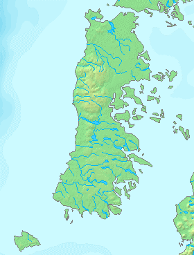
The province of Chiloé includes all the Chiloé Archipelago except the Grupo Desertores islands, plus the Isla Guafo. The area of Chiloé province is 9181 km² (3546 sq mi). The administrative center of the province is Castro, while the episcopal see of the Roman Catholic bishopric is Ancud. Chiloé province is part of the Los Lagos Region (Región de los Lagos), which mainly includes the Chilean lakes region on the mainland north of Chiloé. The administrative center of the region is Puerto Montt.
8,394 km² big Chiloé Island is by far the largest island in the archipelago. Chiloé Island is roughly rectangular with its long axis oriented from north to south. To the east of Chiloé Island lies the Sea of Chiloé which host most of the other islands in the archipelago. The Sea of Chiloé is a marginal sea separating Chiloé Island from Palena Province (also called Continental Chiloé). The principal islands in the sea of Chiloé are Quinchao, Lemuy Tranqui and Desertores Islands. Chiloé Island is separated from the Chilean mainland by the 2 km narrow Chacao Channel in the north. To the northeast and southeast of the archipelago lies the Gulf of Ancud and the Gulf of Corcovado respectively. The former one is part of the Sea of Chiloé. Some 40 km southwest of Chiloé Island lies Guafo Island, the southernmost island of the archipelago.
 Valdivian forest in the southwest of Chiloé Island
Most of the good harbours are located in the north and eastern shore of Chiloé Island. The eastern shore has a series of peninsulas and inlets, notably Estero de Castro where the capital Castro is located. The western part of Chiloé Island as well as the whole Guafo Island are hilly and are covered by forests. In Chiloé Island the hills are subdivided in two north-south ranges separated by the lakes Cucao and Huillinco. The ranges are Piuchén and Pirulil. Their, and the archipelago's highest point does not exceed 800 meters. Depressions in the western forest are occupied by numerous small lakes and bogs scattered across the landscape.
Flora and Fauna
The archipelago's original vegetation is Valdivian temperate rainforest, a forest with a dense understory and a large variety of vegetal species, including mosses and ferns. The western half, as well as the southern half of the island are still largely covered by the native forest. Notable species of the forests include arrayán (Luma apiculata), roble (Nothofagus dombeyi), quila (Chusquea quila), Chilean rhubarb and the avellano (Gevuina avellana). Fitzroya cupressoides and tepú (Tepualia stipularis) grows in the poorly drained soils of the Piuchén and Pirulil Ranges.

The arrival of agriculture in pre-Hispanic times gave origin the patchy of landscape pastures and farms landscape that dominates the eastern and northern coast of Chiloé Island. Some native plants like Gevuina avellana and Fascicularia bicolor have edible seeds, and yet other like the Chilean rhubarb edible stems. The most notable edible plant native to Chiloé are the potatoes of Chiloé.
The native fauna include many birds of which some few are endemic to the archipelago. Among land mammals the largest one is Darwin's Fox and the Pudú, a small deer. Marine mammals include Commerson's dolphins and South American Sea Lions that forms colonies at rock outcrops close to the sea. Different species of whales have been sighted around the island, notably Blue whales.
History

 Nicolás Mascardi depicted here in the Cathedral of Bariloche, was one of the leading Jesuits that used Chiloé as start point for explorations and missionary activity around Nahuel Huapi Lake.
Chiloé Archipelago may very well have been populated since 12,000 – 11,800 B.C according to archaeological discoveries in Monte Verde[1] located less than 50 km to north of the main island. Chiloé's first ethnically identifiable inhabitants are believed to be the Chonos, a sea-faring nomadic people. Later, about hundred years before the arrival of the Spaniards, the Huilliche (a branch of the Mapuche) came from the mainland and settled on the eastern shore, practicing agriculture and fishing.
Spanish colony (1567-1810)
In 1567 the island was first claimed for Spain by Martín Ruiz de Gamboa, who was exploring and claiming the southern part of Chile and many neighbouring islands. Captain Gamboa established a settlement at Castro in 1567, which later became the seat of a Jesuit mission, and was capital of the province until the founding of Ancud in 1768.
During the first years of the colony the spiritual labour was carried out by Mercedarians and Franciscans. The first Jesuits arrived in 1608 and founded in 1612 the first church in Castro. Because of the scattered population living in different islands the Jesuits established a circular Mission system with numerous chapels and churches. By 1767 when the Society of Jesus was suppressed there were 79 chapels. From 1771 onwards the Franciscans took over the functions of the Jesuits in Chiloé.
Ancud was made capital of the Chiloé in 1767. A few years later in 1784 Chiloé Island was made a direct dependency of the colonial viceroyalty of Peru as consequence of the Bourbon reforms, while continental Chile was a captaincy-general within the viceroyalty. The shift of capital and on administration dependency corresponded to a new strategic view on Chiloé Archipelago. While initially Chiloé was viewed by Spaniards as a colony rich enough to conquer, it later became a problematic region due to its isolation from mainland Chile due to geography and the War of Arauco in the mainland. Chiloé Island was largely exempt from the turmoil that affected the Chilean mainland due to conflicts with Huilliches and Mapuches, but was notably affected in 1720 by a large Huilliche rebellion.
During colonial times Chiloé served as base for a series of explorations towards the interior of Patagonia as well as to its channels. The Jesuit Nicolás Mascardi crossed the Andes trough Vuriloche Pass and set up a mission in the shores of Nahuel Huapi Lake in 1670. The Jesuits established in Chiloé bought Chonos from islands south of Chiloé to settle in the archipelago, which led to an aculturization and fusion with into the Spanish-Huilliche culture of the island.
Royalist stronghold (1810–1826)
 Territories controlled by Chile and the Viceroyalty of Perú after the Battle of Chacabuco of 1818. Chiloé and Valdivia were enclaves accessible only by sea.
Unlike the central region of Chile where a long war of independence resumed after a Spanish reoccupation, Chiloé never joined the Patria Vieja (Old Republic), and its population rather than conspiring to overthrow the local Spanish administration gave it wide support. From 1812 and on, men from Chiloé would be enlisted as soldiers and sent to fight in Chile, Bolivia and Peru for the royalist cause. In December 1817 the island became the last stronghold of Spanish royalists (together with Valdivia) fleeing from the Chilean mainland. A Chilean expedition led by Thomas Cochrane, 10th Earl of Dundonald disembarked 60 men under command of William Miller but failed to conquer it after the small but disastrous Battle of Agüi. Another unsuccessful conquest attempt occurred in in 1824 when Jorge Beauchef, who had disembarked in Chiloé Island, was ambushed at the Battle of Mocopulli. Only on 15 January 1826 did the Spanish forces of Antonio de Quintanilla negotiated a surrender to a new military expedition led by Ramon Freire, and the island was fully incorporated into the independent Republic of Chile, although Spain did not recognize it until 1844.
The last Spanish military governors were:
- Mariano Osorio December 1817–1818
- Antonio de Quintanilla 1818 – 15 January 1826
Chilean republic (1826-1982)
Charles Darwin visited Chiloé during the summer of 1834–1835, writing about his impressions of southern Chile in his diaries.[2] As an old royalist stronghold the inhabitants of the archipelago were known during the 19th century for complaining about not having a king. Charles Darwin wrote about his visit to Chiloé in 1834: The Indians ended all their complaints by saying, "And it is only because we are poor Indians, and know nothing; but it was not so when we had a King."
As Chiloé had been a defensive stronghold during colonial times, the Republic of Chile used Chiloé as a starting point for its territorial expansion into the southern territories. The expedition to the Straits of Magellan, that founded Fuerte Bulnes in 1843, was assembled in Chiloé. In the 1850s Chiloé was again instrumental in the logistical support of the colonization of the Llanquihue Lake, where German settlers were given land. The last major portion of Patagonia to be incorporated into Chile, Aysén was also explored and settled from Chiloé. In the colonization process of Patagonia, Chilotes immigrants constituted a large part of the work force of the livestock enterprises that were established in Patagonia between 1890 and 1950.
During the late 19th century and the beginning of the 20th century Chiloé lost economic and political importance to Puerto Montt on the mainland, so that by 1863 Puerto Montt was made capital of its own province and in 1927 the Chiloé Archipelago was incorporated into a new province headed by Puerto Montt.
The cathedral in Ancud was totally destroyed and Castro was badly damaged by the Great Chilean Earthquake of 1960, widely considered to be the most powerful ever recorded. In 1982, the provincial capital, after over 200 years, was returned to Castro.
Culture
In part because of its physical isolation from the rest of Chile, Chiloé has a very special architecture and local culture. During the colonization of Patagonia and southern Chile in the 19th century cultural elements of Chiloé spread to that zones as many chilotes migrated and settled there.
Architecture
 This church near Chacao bears evidence of baroque and neoclassical elemets introduced by clergy in colonial timesMain article: Chilota architecture
Chilotan architecture is a unique architectural style that is mainly restricted to Chiloe Island and nearby areas. In part because of its physical isolation from the rest of Chile, and access to different materials, Chiloé has a very special architecture that differs most greatly from the typical Spanish colonial architecture. The Spanish who arrived in the 16th century, and Jesuit missionaries who followed, constructed hundreds of small wooden churches in an attempt to bring Christianity to a pagan land; the result was a mixing of Catholicism and pagan beliefs. These unique buildings have been designated a UNESCO World Heritage Site.
Nearly all the houses and buildings in colonial Chiloe were built with wood, and wood shingles were extensively employed. Roof shingles of Fitzroya came to be used as money and called "Real de Alerce". In the late 19th century many palafitos (stilt houses) were built in cities like Castro and Chonchi.
Chilote Spanish
Main article: Chilote SpanishChilote is a dialect of Spanish language spoken on Chiloé Archipelago. It has distinct differences from standard Chilean Spanish in accent, pronunciation, grammar and vocabulary, especially influenced by the Huilliche variant of Mapudungun.
Cuisine
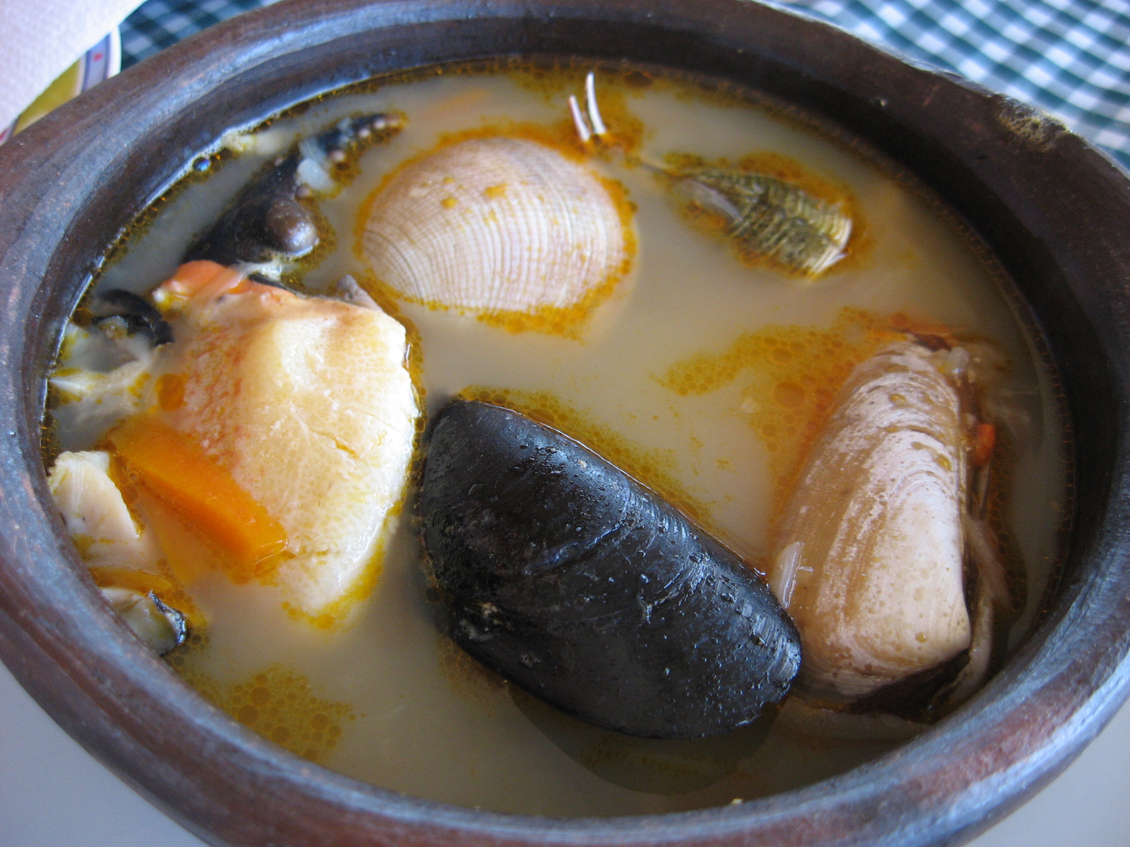
Main article: Cuisine of Chiloé A paila marina.
The cuisine of Chiloé has its origin in pre-Hispanic traditions among native Chonos and Huilliches. Typical features of Chilote cuisine include earth oven and asado barbecues. Chilote cuisine makes extensive use fish, shellfish and potatoes of which there are plenty of varieties growing in the archipelago's different islands. Lamb is considered the most appreciated meat and is eaten and prepared as an asado, specially around Christmas and new year. Apple chicha is a common alcoholic beverage. Other typical alcoholic beverages are murtado and licor de oro liqueurs. Common dishes include curanto, paila marina and pulmay.
Mythology
Main articles: Chilote mythology and Chiloé creation mythChiloé have a rich folklore with many mythological animals and spirits (the Caleuche, the Trauco, the Pincoya, the Invunche, etc.). Chilota mythology is based on a mixture of indigenous religions (the Chonos and Huilliches) that live in the Archipelago of Chiloé, and the legends and superstitions brought by the Spanish Conquistadores, who in 1567 began the process of conquest in Chiloé and with it the fusion of elements that would form a separate mythology. Chilota mythology flourished, isolated from other beliefs and myths in Chile, due to the separation of the archipelago from the rest of the Spanish occupation in Chile, when the Mapuches occupied or destroyed by all the Spanish settlements between the Bío-Bío River and the Chacao channel following the disaster of Curalaba in 1598.
According to Chilotan mythology the origin of the archipelago lies in a fierce battle between two serpents, Ten Ten-Vilu (ten="earth", vilu="snake") and Coi Coi-Vilu (Co="water", vilu="snake").
Demographics and economy

The population of the province with its ten municipalities according to the 2002 census was 154,775; of this, 44% lived in rural areas, according to the National Statistics Institute (INE). Chiloé's people are known as Chilotes.
Salmon aquaculture, tourism, agriculture and timber are the mainstays of the island economy.
Tourism
Having evolved for centuries isolated from mainland Chile, the "Chilotes" developed a strong, self-reliant culture, rich in folklore, mythology and tradition. This very identity is what constitutes the island's major attraction for domestic tourists in Chile and increasingly, for international tourists. As in the Calakmul case above, tourism to Chiloé is very strongly based on the island's cultural heritage, predominantly consisting of crafts markets, appreciation of cultural landscapes, museum exhibitions, seafood cuisine and architectural heritage (Chiloé's old churches). However, the average tourist to the island will have little opportunity to see Chilotes involved in their living cultural activities, such as the elaborate preparation of the islands famous "curanto" meal, rich in shellfish, meat and potatoes, the management practices of their farm and forest lands, boat building and more.
In order to overcome the cultural and organizational barriers that keep suppliers of living cultural heritage and tour operators apart, the Chiloé diocese of Ancud established a private foundation called "Fundación con Todos" (One for All Foundation). Among other activities, the Foundation has played a key role in helping a number of Chilote households organize themselves into an "agrotourism" network. The Foundation helped Chilote households make the preparation required to accommodate tourists (including training in sanitation and maintenance of facilities, the provision of basic infrastructure) and complemented this effort with a professional marketing campaign. These works were undertaken with the financial support of other agencies.
Again, in cooperation with the EOMF and the Chiloé Model Forest, a cultural and natural heritage tour was organized to Argentina and Chile, including a three-day visit to Chiloé, permitting some of the Chilote households to host a group of cultural heritage tourists for the first time. The visits were very successful and should be the first of more to come, helping establish the credibility of Chiloé's agrotourism network among other tour operators.[3]
References
- ^ Dillehay, Tom, Monteverde: A late Pleistocene settlement in Chile (Smithsonian Institution Press, Washington, 1989)
- ^ [1]
- ^ http://www.chin.gc.ca/Resources/Icom/English/Collection/e_texte_mp.html
www.chiloeextreme.cl
Chiloé Archipelago Main islands 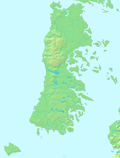
Water bodies Gulf of Ancud · Estero de Castro · Caulín Bay · Chacao Channel · Sea of Chiloé · Gulf of Corcovado · Dalcahue ChannelCities and towns Culture ClothingAsado · Chapalele · Curanto · Licor de oro · Murtado · Mate (Huarisnaque) · Milcao · Murta con membrillo · Paila marina · Potatoes of Chiloé · Pulmay1: These islands are not part of Chiloé Province Categories:- Chiloé Archipelago
- Archipelagoes of Chile


Wikimedia Foundation. 2010.