- Masbury railway station
-
Masbury 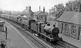
Masbury Station, with Up express in 1959 Location Place nr Shepton Mallet Area Mendip Grid reference ST604473 Operations Pre-grouping Somerset and Dorset Joint Railway Post-grouping SR and LMSR
Western Region of British RailwaysPlatforms 2 History 20 July 1874 Opened (Masbury) 26 September 1938 Renamed (Masbury Halt) 7 March 1966 Closed Disused railway stations in the United Kingdom Closed railway stations in Britain
A B C D–F G H–J K–L M–O P–R S T–V W–ZMasbury railway station was a small isolated station on the Somerset and Dorset Joint Railway's main line between Evercreech Junction and Bath. It was situated to the north of Shepton Mallet and near the summit of the line as it crossed the Mendip Hills. The station opened in 1874 and closed with the rest of the line under the Beeching Axe in March 1966.
Maesbury Railway Cutting is a 2 hectare geological Site of Special Scientific Interest between East Horrington and Gurney Slade and a Geological Conservation Review site because it exposes approximately 135 metres of strata representing the middle and upper Lower Limestone Shales and the basal Black Rock Limestone. Both formations are of early Carboniferous (Courceyan) age. It lies close to the Iron Age hill fort Maesbury Castle.
The station was never heavily used, and from 1938 it was reduced to a "halt" status. A feature of the station was a substantial stone-built stationmaster's house on the main northbound platform. The front of the house, which is still standing and in private hands, features a fanciful carving of Maesbury Castle as a medieval castle: in fact, Maesbury is an Iron Age fort nearby. There is about half a mile of ramparts and views to Glastonbury Tor. It is mostly on private land but a public footpath crosses it.
Preceding station Disused railways Following station Shepton Mallet
(Charlton Road)
Line and station closedSomerset & Dorset Joint Railway
LSWR & Midland RailwaysBinegar
Line and station closedReferences
- Somerset Railway Stations, by Mike Oakley, Dovecote Press, 2002.
- Station on navigable O.S. map
- Station remains
Categories:- Disused railway stations in Somerset
- Former Somerset and Dorset Joint Railway stations
- Railway stations opened in 1874
- Railway stations closed in 1966
- Beeching closures in England
- South West England railway station stubs

Wikimedia Foundation. 2010.