- De L'Église (Montreal Metro)
-
 Montreal Metro Station
Borough Verdun City Montreal Opened 3 September 1978 Line  Green Line
Architect Lemay et Leduc Artist Claude Théberge and Antoine D. Lamarche Platform Depth 19.8 metres (Honoré-Beaugrand platform)
25.6 (Angrignon platform)Rank 5th deepest Traffic 2,295,037 entrances in 2006 Rank 40th busiest Interstation
Distance563.86 metres to Verdun
812.30 metres to LaSalleAddress of
Entrances250 Galt Avenue
133 de l'Église AvenueNearby Main
IntersectionsGalt Avenue / Wellington Street
de l'Église Avenue / Ross StreetDe L'Église (French; literally translated, "of the Church") is a station on the Green Line of the Montreal Metro rapid transit system operated by the Société de transport de Montréal (STM). It is located in the borough of Verdun in Montreal, Quebec, Canada [2]. The station opened on September 3, 1978, as part of the extension of the Green Line westward to Angrignon.
Contents
Architecture and art
 Station's kiosks
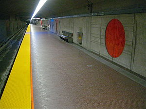
Designed by Jean-Maurice Dubé, it was planned as a normal side platform station. However, during the station's construction, a cave-in of the surrounding weak Utica Shale formation made it necessary to build the station with a narrower profile. It is therefore built with stacked platforms, with the Honoré-Beaugrand platform above and Angrignon below, and both directions opening to the left instead of the usual right. There are two accesses, one in the centre and one at the western end of the station, with separate ticket halls.
The station is decorated with a series of circular motifs in ceramic tile on the lower levels and concrete bas-reliefs in the upper levels, by Claude Théberge.
Origin of the name
This station is named for av. de l'Église. The church in question is the Église Saint-Paul in the Côte-Saint-Paul district at the north end of the avenue. This roadway has existed since at least 1834, and became known under its present name some time after 1879.
Connecting bus routes
Main article: List of Montreal Bus RoutesRoute Service Times Map Schedule Société de transport de Montréal  37 Jolicoeur
All-day Map Schedule 58 WellingtonAll-day Map Schedule 61 WellingtonAll-day Map Schedule  350 Verdun/LaSalle
Overnight Map Schedule Nearby points of interest
- Centre hospitalier Angrignon, Verdun pavilion
- Verdun Auditorium
- Parc Thérien
- Health Canada
References
External links
 Media related to De L'Église (Montreal Metro) at Wikimedia Commons
- De L'Église Station - official site
- Montreal by Metro, metrodemontreal.com - photos, information, and trivia
Line 1 Green Angrignon • Monk • Jolicoeur • Verdun • De L'Église • LaSalle • Charlevoix • Lionel-Groulx • Atwater • Guy-Concordia • Peel • McGill • Place-des-Arts • Saint-Laurent • Berri-UQAM • Beaudry • Papineau • Frontenac • Préfontaine • Joliette • Pie-IX • Viau • Assomption • Cadillac • Langelier • Radisson • Honoré-BeaugrandLine 2 Orange Côte-Vertu • Du Collège • De La Savane • Namur • Plamondon • Côte-Sainte-Catherine • Snowdon • Villa-Maria • Vendôme • Place-Saint-Henri • Lionel-Groulx • Georges-Vanier • Lucien-L'Allier • Bonaventure • Square-Victoria • Place-d'Armes • Champ-de-Mars • Berri-UQAM • Sherbrooke • Mont-Royal • Laurier • Rosemont • Beaubien • Jean-Talon • Jarry • Crémazie • Sauvé • Henri-Bourassa • Cartier • De La Concorde • MontmorencyLine 4 Yellow Line 5 Blue Snowdon • Côte-des-Neiges • Université-de-Montréal • Édouard-Montpetit • Outremont • Acadie • Parc • De Castelnau • Jean-Talon • Fabre • D'Iberville • Saint-MichelCoordinates: 45°27′44″N 73°34′02″W / 45.46222°N 73.56722°W
Categories:- Montreal Metro Green Line


Wikimedia Foundation. 2010.