- Outremont (Montreal Metro)
-
 Montreal Metro Station
Borough Outremont City Montreal Opened 4 January 1988 Line  Blue Line
Architect Dupuis, Chapuis, & Dubuc Artist Gilbert Poissant Platform Depth 13.8 metres Rank 38th deepest Traffic 1,176,723 entrances in 2006 Rank 57th busiest Interstation
Distance1090.60 metres to Édouard-Montpetit
728.60 metres to Acadie
Address of
Entrances1400, Van Horne Avenue Nearby Main
IntersectionsVan Horne Avenue / Wiseman Avenue [1]
Outremont is a station on the Blue Line of the Montreal Metro rapid transit system, operated by the Société de transport de Montréal (STM) . It is located in the Outremont borough of Montreal, Quebec, Canada [2].Contents
Overview
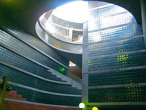
It is a normal side platform station with a mined trainroom and open-cut volume at one end, containing the ticket hall and topped by the one large entrance and a glazed skylight. Classic materials and a mural of glazed ceramics by Gilbert Poissant evoke the architecture of the surrounding neighbourhood, as does a City of Outremont lamp post at the foot of the stairs to one platform.
Origin of name
The station takes its name from the borough (formerly city) of Outremont, in which it is located. Originally named Côte-Sainte-Catherine, the town took its name in 1875 from a mansion, still extant, built in 1833 by Louis-Tancrède Bouthillier and named "Outre-Mont" ("beyond the mountain" from the main settlement of Montreal).
Connecting bus routes
Main article: Société de transport de MontréalMain article: List of Montreal Bus RoutesRoute Service Times Map Schedule Société de transport de Montréal  160 Barclay
All-day Map Schedule 161 Van HorneAll-day Map Schedule  368 Mont-Royal
Overnight Map Schedule 370 RosemontOvernight Map Schedule Nearby points of interest
- Collège Stanislas
- Théâtre Outremont
- Cathédrale arménienne Saint-Grégoire l'Illuminateur
References
External links
- Outremont station on STM website
- Montreal by Metro, metrodemontreal.com
- 2008 STM System Map
- Metro Map
Line 1 Green Angrignon • Monk • Jolicoeur • Verdun • De L'Église • LaSalle • Charlevoix • Lionel-Groulx • Atwater • Guy-Concordia • Peel • McGill • Place-des-Arts • Saint-Laurent • Berri-UQAM • Beaudry • Papineau • Frontenac • Préfontaine • Joliette • Pie-IX • Viau • Assomption • Cadillac • Langelier • Radisson • Honoré-BeaugrandLine 2 Orange Côte-Vertu • Du Collège • De La Savane • Namur • Plamondon • Côte-Sainte-Catherine • Snowdon • Villa-Maria • Vendôme • Place-Saint-Henri • Lionel-Groulx • Georges-Vanier • Lucien-L'Allier • Bonaventure • Square-Victoria • Place-d'Armes • Champ-de-Mars • Berri-UQAM • Sherbrooke • Mont-Royal • Laurier • Rosemont • Beaubien • Jean-Talon • Jarry • Crémazie • Sauvé • Henri-Bourassa • Cartier • De La Concorde • MontmorencyLine 4 Yellow Line 5 Blue Snowdon • Côte-des-Neiges • Université-de-Montréal • Édouard-Montpetit • Outremont • Acadie • Parc • De Castelnau • Jean-Talon • Fabre • D'Iberville • Saint-MichelCoordinates: 45°31′12.87″N 73°36′53.72″W / 45.5202417°N 73.6149222°W
Categories:- Montreal Metro Blue Line
- Rapid transit stubs

Wikimedia Foundation. 2010.