- Corona de Tucson, Arizona
-
Corona de Tucson, Arizona — CDP — Corona de Tucson and Santa Rita foothills Location in Pima County and the state of Arizona
Coordinates: 31°57′28″N 110°46′2″W / 31.95778°N 110.76722°WCoordinates: 31°57′28″N 110°46′2″W / 31.95778°N 110.76722°W Country United States State Arizona County Pima Area – Total 2.6 sq mi (6.6 km2) – Land 2.6 sq mi (6.6 km2) – Water 0.0 sq mi (0.0 km2) Elevation 3,281 ft (1,000 m) Population (2010) – Total 5,675 – Density 312.7/sq mi (123.2/km2) Time zone MST (no DST) (UTC-7) ZIP code 85641 Area code(s) 520 FIPS code 04-16030 GNIS feature ID 0037250 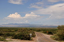 View of Sierrita Mountains and copper mines from Corona de Tucson
Corona de Tucson is a census-designated place (CDP) in Pima County, Arizona, United States. The population was 5,675 at the 2010 census, an increase of 598% from the 2000 population of 813.
Corona de Tucson is in the Vail, Arizona 85641 ZIP code area.
Contents
Geography
Corona de Tucson is located at 31°57′28″N 110°46′2″W / 31.95778°N 110.76722°W (31.957860, -110.767238),[1] in the foothills of the Santa Rita Mountains, and adjacent to the Coronado National Forest.
According to the United States Census Bureau, the CDP has a total area of 2.6 square miles (6.7 km2), all of it land.
Demographics
As of the census[2] of 2000, there were 813 people, 376 households, and 280 families residing in the CDP. The population density was 317.2 people per square mile (122.6/km²). There were 395 housing units at an average density of 154.1/sq mi (59.6/km²). The racial makeup of the CDP was 95.20% White, 0.25% Black or African American, 0.37% Native American, 0.37% Asian, 0.12% Pacific Islander, 1.72% from other races, and 1.97% from two or more races. 6.77% of the population were Hispanic or Latino of any race.
There were 376 households out of which 17.8% had children under the age of 18 living with them, 68.1% were married couples living together, 4.3% had a female householder with no husband present, and 25.3% were non-families. 21.3% of all households were made up of individuals and 8.5% had someone living alone who was 65 years of age or older. The average household size was 2.16 and the average family size was 2.48.
In the CDP the population was spread out with 13.9% under the age of 18, 4.1% from 18 to 24, 19.4% from 25 to 44, 38.6% from 45 to 64, and 24.0% who were 65 years of age or older. The median age was 51 years. For every 100 females there were 91.7 males. For every 100 females age 18 and over, there were 91.8 males.
The median income for a household in the CDP was $52,813, and the median income for a family was $61,375. Males had a median income of $49,722 versus $31,250 for females. The per capita income for the CDP was $28,304. None of the families and 1.0% of the population were living below the poverty line, including no under eighteens and none of those over 64.
See also
References
- ^ "US Gazetteer files: 2010, 2000, and 1990". United States Census Bureau. 2011-02-12. http://www.census.gov/geo/www/gazetteer/gazette.html. Retrieved 2011-04-23.
- ^ "American FactFinder". United States Census Bureau. http://factfinder.census.gov. Retrieved 2008-01-31.
External links
- Corona de Tucson profile at City-Data.com
- Corona Foothills Middle School
- Corona De Tucson Fire Department
Municipalities and communities of Pima County, Arizona Cities 
Towns CDPs Ajo | Avra Valley | Casas Adobes | Catalina | Catalina Foothills | Corona de Tucson | Drexel-Alvernon | Drexel Heights | East Sahuarita | Flowing Wells | Green Valley | Littletown | Picture Rocks | Pisinemo | Rincon Valley | Santa Rosa | Sells | Summit | Tanque Verde | Three Points | Tortolita | Tucson Estates | Vail | Valencia West
Unincorporated
communitiesIndian reservations Ghost towns Allen | Cerro Colorado | Helvetia | Kentucky Camp | Redington | Total Wreck
Categories:- Census-designated places in Pima County, Arizona
- Populated places in the Sonoran Desert


Wikimedia Foundation. 2010.