- Düsseldorf-Urdenbach
-
 timber framed house
 Calvinist Church
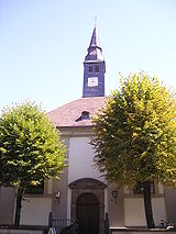
 Roman Catholic Church
Urdenbach is an urban borough of Düsseldorf. It is located in the south of the city, next to the neighboring town Monheim am Rhein and bordered by the river Rhine.
History
The river Rhine changed his way in the 14. century A.C. at the place today Urdenbach is located. It was not only a fishing settlement, but a place of trading. There are a lot of timber framed houses, built up in that era. The Calvinist Church is from the year 1692, constructed in the baroque style. The Roman Catholic Church was built in Neo-romanesque style in 1893. Urdenbach became part of Düsseldorf in 1929.
The Benrath line, the line between northern German pronunciations and southern German pronunciations goes across Urdenbach.
Statistics
 Gymnasium Koblenzer Straße
- area: 7,64 km²
- population: about 10,500 people
- Grundschule: 2
- Gymnasiums: 1
- no highway connection, no station, no tram line
- 2 bus lines (784, 788)
- 1 federal road tangenting Urdenbach
References
- This article incorporates information from the German Wikipedia.
Districts of Düsseldorf District 1 · District 2 · District 3 · District 4 · District 5 · District 6 · District 7 · District 8 · District 9 · District 10 District 1: Altstadt · Derendorf · Golzheim · Carlstadt · Pempelfort · Stadtmitte | District 2: Düsseltal · Flingern-Nord · Flingern-Süd | District 3: Bilk · Flehe · Friedrichstadt · Hafen · Hamm · Oberbilk · Unterbilk · Volmerswerth | District 4: Heerdt · Lörick · Niederkassel · Oberkassel | District 5: Angermund · Kaiserswerth · Kalkum · Lohausen · Stockum · Wittlaer | District 6: Lichtenbroich · Mörsenbroich · Rath · Unterrath | District 7: Gerresheim · Grafenberg · Hubbelrath · Ludenberg | District 8: Eller · Lierenfeld · Unterbach · Vennhausen | District 9: Benrath · Hassels · Himmelgeist · Holthausen · Itter · Reisholz · Urdenbach · Wersten | District 10: Garath · HellerhofCategories:
- Urban districts and boroughs of Düsseldorf
- Düsseldorf


Wikimedia Foundation. 2010.