- D&R Canal Trail
-
D&R Canal trail [[file: |250px]]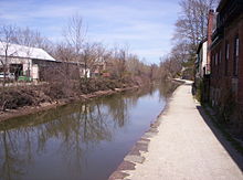

Lambertville, NJ Length 77 miles (124 km) Trailheads Trenton
Frenchtown
New BrunswickUse Hiking, Cycling Trail difficulty Easy Season Year round Hazards Road crossings, adjacent canal Surface Stone dust ROW United New Jersey Railroad and Canal Company Website Official D&R Canal Park site The D&R Canal trail is a recreational trail in the U.S. state of New Jersey. The 77-mile (124 km) trail is made up of three segments that transverse three counties: a canal towpath from New Brunswick to Trenton; a canal towpath / rail trail from Trenton to Bull's Island; and a rail trail from Bull's Island to Frenchtown. The three combined trails together form the largest completed trail entirely in New Jersey.[citation needed]
Much of the trail runs along the existing Delaware & Raritan Canal inside the New Jersey state park of the same name.
The proposed Capital to Coast Trail is planned to connect to the D&R Canal Trail.
Note: There is no direct connection between the main canal and the feeder canal paths along the Delaware River. Signed on-street connections are required to traverse the entire trail system.
Contents
Main Canal Towpath
The main canal towpath trail is 29 miles (47 km) long and constructed on the earthen towpath used by mules to pull barges along the canal, the surface is packed dirt, gravel and crushed stone. Parts become muddy in wet weather; parts are covered with coarse sharp stones similar to track ballast and dangerous to road bike tires. However, the majority of the path was resurfaced in early 2011 and is rideable by all but the thinnest road tires. The main entrance in New Brunswick is at the Landing Lane Bridge.
Major Access Points (with parking)
- New Brunswick/Landing Lane Bridge
- Route 287/Somerset
- Bound Brook
- Manville Causeway/Weston
- Amwell Road
- Griggstown Causeway, Princeton
- Alexander Street, Princeton
Feeder Canal Towpath/Rail-trail
The feeder canal was used to supply water to the main canal from the Delaware River, this towpath eventually had rail laid along its length which provides a firm foundation common to rail-trails; the surface is crushed stone. The feeder canal, including the rail-trail to Frenchtown is 28.7 miles (46.2 km) long.
Major Access Points (with parking)
- Washington Crossing State Park
- Lambertville (on street parking)
- Jimison Farm (~1 mile+ north of Lambertville) Jimison Farm website
- Stockton
- Prallsville Mills
- Bull's Island
Public restrooms can be found at Washington's Crossing, Prallsville Mills, and Bulls' Island.
Food can be found "on trail" at Washington's Crossing, Lambertville, and Stockton.
The state of New Jersey has published this guide to cycling the feeder path.
Rail-Trail
Technically the D&R canal starts at Bull's Island (now a state campground); the trail north of the Bull's Island inlet is strictly a rail-trail on the rail bed of the United New Jersey Railroad and Canal Company; the surface is crushed stone. Boarded by Route 29 on the east, and the Delaware River on the west there are few access points along its length, the path is also less heavily traveled than the southern feeder canal segment. During the summer months much of the rail-trail segment is shaded with an overhead canopy of foliage providing a cool hiking or biking environment.
Major Access Points (with parking)
- Bulls Island
- Frenchtown
Public restrooms can be found at Bulls' Island.
Food can be found "on trail" at Frenchtown.
External links
Categories:- Rail trails in New Jersey
- Bike paths in New Jersey
- Protected areas of Hunterdon County, New Jersey
- Protected areas of Mercer County, New Jersey
- Protected areas of Middlesex County, New Jersey
- Protected areas of Somerset County, New Jersey
- National Recreation Trails of the United States

Wikimedia Foundation. 2010.