- San Francisco Peaks
-
Coordinates: 35°20′27″N 111°41′00″W / 35.34083°N 111.6833333°W
San Francisco Peaks Dookʼoʼoosłííd (Navajo)
Nuvatukya’ovi (Hopi)Range  The San Francisco Peaks viewed from atop nearby 9,000 ft Mount Elden
Country United States State Arizona Highest point Humphreys Peak - elevation 12,633 ft (3,851 m) - coordinates 35°20′47″N 111°40′40″W / 35.34639°N 111.67778°W Geology volcano The San Francisco Peaks are a volcanic mountain range located in north central Arizona, just north of Flagstaff. The highest summit in the range, Humphreys Peak, is the highest point in the state of Arizona at 12,633 feet (3,851 m) in elevation. The San Francisco Peaks are the remains of an eroded stratovolcano.[1] An aquifer within the caldera supplies much of Flagstaff's water while the mountain itself is located within the Coconino National Forest and is a popular site for outdoor recreation. The Arizona Snowbowl ski area is located on the western slopes of Humphreys Peak, and has been the subject of major controversy involving several tribes and environmental groups.[2][3]
Contents
History
The San Francisco Peaks have considerable religious significance to thirteen local American Indian tribes (including the Havasupai, Navajo, Hopi, and Zuni.) In particular, the peaks form the Navajo sacred mountain of the west, called Dook'o'oosłííd. The peaks are associated with the color yellow, and they are said to contain abalone inside, to be secured to the ground with a sunbeam, and to be covered with yellow clouds and evening twilight. They are gendered female.[4]
For the Hopi people, the San Francisco Peaks are associated with the cardinal direction southwest, constitute ritually pure sacred spaces, and are used as sources for ceremonial objects.[5] The alignment of the sunset from the Peaks to Hopi villages on Black Mesa is used to calculate the winter solstice, signifying "the beginning of a new year, with a new planting season and new life."[6] The peaks are seen as the home of the katsinam or Kachina spirits, ancestors who have become clouds following their death.[6] Katsinam are invited to Hopi villages to serve as ethical and spiritual guides to the Hopi community from midwinter to midsummer. Aaloosaktukwi or Humphrey's Peak holds particular religious significance and is associated with the deity Aaloosaka, a symbol of the Two-Horn Society, a religious group among the Hopi dating to the occupation of the Awat’ovi village on Antelope Mesa.[6] Depiction of the peaks in association with calendar-keeping is attested in a kiva at the Hisatsinom settlement of Homol'ovi, which was occupied between AD 1250 and 1425;[6] katsinam imagery dates to the thirteenth century as well.[6] Other Native American peoples also relate Kachina spirits to heavy snowfalls on the Peaks.
In 1629, one hundred and forty seven years before San Francisco, California, received that name, Spanish friars founded a mission at a Hopi Indian village in honor of St. Francis, sixty five miles from the Peaks. 17th century Franciscans at Oraibi village gave the name San Francisco to the peaks to honor St. Francis of Assisi, the founder of their order.[7] The mountain man Antoine Leroux visited the San Francisco Peaks in the mid-1850s, and guided several American expeditions exploring and surveying northern Arizona. Leroux guided them to the only reliable spring, one on the western side of the Peaks, which was later named Leroux Springs.
Around 1877, John Willard Young, a son of the Mormon leader Brigham Young, claimed the area around Leroux Springs, and he built Fort Moroni, a log stockade, to house railroad tie-cutters for the Atlantic & Pacific Railroad, which was then being built across northern Arizona.[8]
The biologist Clinton Hart Merriam studied these mountains and surrounding areas in 1889, describing a set of six life zones found from the bottom of the Grand Canyon to the summit of the mountains, based on the factors of elevation, latitude, and average precipitation. He designated their characteristic flora, as follows:
- Lower Sonoran Zone - Sonoran Desert plants
- Upper Sonoran Zone - Pinyon and Juniper woodlands
- Transition Zone - Ponderosa Pine forests
- Canadian Zone - Mixed Conifer Forest
- Hudsonian Zone - Spruce-Fir or Subalpine Conifer Forest
- Arctic-Alpine Zone - alpine tundra
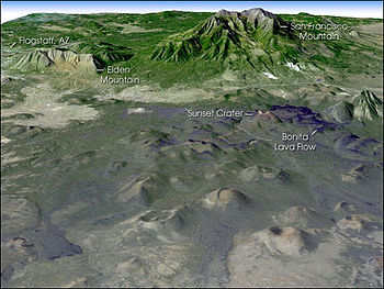 Composite image of the Peaks and the San Francisco volcanic field, looking SW towards Flagstaff. NASA image from satellite imagery projected onto a digital elevation model.
Merriam considered that these life zones could be extended to cover all the world's vegetation types with the addition of only one more zone, the tropical zone. His pioneering studies remained one of the most widespread climate zone classifications, in use for nearly 80 years.
In 1898, U.S. President William McKinley established the San Francisco Mountain Forest Reserve, at the request of Gifford Pinchot, the head of the U.S. Division of Forestry. The local reaction was hostile—citizens of Williams, Arizona, held a significant protest, and the Williams News editorialized that the reserve "virtually destroys Coconino County."[8] In 1908, the San Francisco Mountain Forest Reserve became a part of the new Coconino National Forest.
Outdoor recreation and controversy
The mountain provides a number of recreational opportunities, including wintertime snow skiing and hiking the rest of the year. Hart Prairie is a popular hiking area and Nature Conservancy preserve located below the mountain's ski resort, Arizona Snowbowl.
In 2002, the Arizona Snowbowl proposed a plan to expand the ski resort and begin snowmaking using reclaimed water made of treated sewage effluent. A coalition of Indian tribes and environmental groups sued the Coconino National Forest, which leases the land to the ski resort, in an attempt to stop this proposed expansion, citing serious impacts to cultural practitioners, public health risks, and environmental concerns.[3]
In 2011, construction began on a wastewater pipeline to the Peaks. In response, there has been an ongoing series of protest actions including demonstrations, encampments, and multiple lockdowns in which protesters have locked themselves to construction equipment.[9][10][unreliable source?] Notable protesters include Navajo musician Klee Benally, singer/guitarist for the punk rock band Blackfire, who has been arrested twice since protests began.[11][12][unreliable source?]
Geography
 The Peaks in winter, 2004
 The San Francisco Peaks (with Agassiz center) in the Fall of 2007.
The four highest individual peaks in Arizona are contained in the range:
- Humphreys Peak, 12,633 feet (3,851 m)
- Agassiz Peak, 12,356 feet (3,766 m)
- Fremont Peak, 11,969 feet (3,648 m)
- Aubineau Peak, 11,838 feet (3,608 m)
- Rees Peak, 11,474 feet (3,497 m)
- Doyle Peak, 11,460 feet (3,493 m)
The San Francisco Peaks are the home of the only alpine tundra environment in Arizona, the only place where the threatened San Francisco Peaks groundsel (Packera franciscana) is found.[13][14][15]
Names in local languages
 Fall colors, Lockett Meadow, 1996
- Dook'o'oosłííd—(Navajo)
- Nuva'tuk-iya-ovi—(Hopi)
- Dził Tso—Dilzhe’e—(Apache)
- Tsii Bina—Aa'ku—(Acoma)
- Nuvaxatuh—Nuwuvi—(Southern Paiute)
- Hvehasahpatch or Huassapatch—Havasu 'Baaja—(Havasupai)
- Wik'hanbaja—Hwal`bay—(Hualapai)
- Wimonagaw'a—Yavapai
- Sunha K'hbchu Yalanne—A:shiwi (Zuni)
- 'Amat 'Iikwe Nyava[16]—Hamakhav—(Mojave)
- Sierra sin Agua—(Spanish)
- The Peaks—(Anglo) Arizonans
Source:[8]See also
References
- ^ "San Francisco Peaks". USGS factsheet. http://geopubs.wr.usgs.gov/fact-sheet/fs017-01/. Retrieved 2006-12-16.
- ^ "San Francisco Peaks, AZ". NASA Earth Observatory. http://earthobservatory.nasa.gov/Newsroom/NewImages/images.php3?img_id=10874. Retrieved 2006-05-23.
- ^ a b Nasaw, Daniel (2011-10-19). "Indians oppose 'recycled' sewage for Arizona skiing". BBC News Magazine, Washington (BBC). http://www.bbc.co.uk/news/magazine-15176711.
- ^ Robert S. McPherson, Sacred Land, Sacred View: Navajo perceptions of the Four Corners Region, Brigham Young University, ISBN 1-56085-008-6.
- ^ Glowacka, Maria; Dorothy Washburn, Justin Richland (2009). "Nuvatukya'ovi, San Francisco Peaks.". Current Anthropology 50 (4): 553–556. doi:10.1086/599069. ISSN 00113204.
- ^ a b c d e Glowacka, Maria; Dorothy Washburn, Justin Richland (2009). "Nuvatukya'ovi, San Francisco Peaks.". Current Anthropology 50 (4): 555. doi:10.1086/599069. ISSN 00113204.
- ^ Cline, Platt (1976). They Came to the Mountain. Flagstaff: Northern Arizona University with Old Town Press.
- ^ a b c Houk, Rose (2003). "San Francisco Peaks". The Mountains Know Arizona. Arizona Highways Books.
- ^ http://bsnorrell.blogspot.com/2011/06/photos-san-francisco-peaks-lock-down.html
- ^ http://earthfirstnews.wordpress.com/2011/08/08/flagstaff-police-attack-and-arrest-san-francisco-peaks-marchers/
- ^ http://narcosphere.narconews.com/notebook/brenda-norrell/2011/08/navajo-klee-benally-locks-down-snowbowl-equipment
- ^ http://climate-connections.org/2011/08/08/flagstaff-police-attack-and-arrest-san-francisco-peaks-marchers/
- ^ Epple, Anne Orth; Epple, Lewis E. (1995). A Field Guide to the Plants of Arizona. Falcon Publishing.
- ^ "Alpine Tundra". Arizona Game and Fish Department. http://explore.azgfd.gov/Default.as?tabid=55. Retrieved 2006-09-09.
- ^ Kachina Peaks Wilderness - GORP
- ^ Munro, P et al. A Mojave Dictionary Los Angeles: UCLA, 1992
Further reading
- Duffield, Wendell A., 1998, Volcanoes of Northern Arizona, Flagstaff, Grand Canyon Association. ISBN 0938216589. Reviews
 San Francisco Peaks viewed from U.S. Route 89
 180 degree S/W panorama from the top of the Agassiz Peak chairlift
External links
- Shaded relief map of the Peaks, showing locations of the principal peaks
- San Francisco Peaks at Coconino National Forest
- San Francisco Peak Trails at HikeArizona.COM
- Live webcam of the San Francisco Peaks
- Hart Prairie Preserve at Nature Conservancy
Categories:- Articles with Hopi language external links
- Religious places of the indigenous peoples of North America
- Volcanoes of Arizona
- Mountain ranges of Arizona
- Sacred mountains
- Landforms of Coconino County, Arizona
- Stratovolcanoes
- Extinct volcanoes


Wikimedia Foundation. 2010.