- Otricoli
-
Otricoli — Comune — Comune di Otricoli Location of Otricoli in Italy
 Otricoli
Coordinates: 42°25′N 12°29′E / 42.417°N 12.483°ECoordinates: 42°25′N 12°29′E / 42.417°N 12.483°E Country Italy Region Umbria Province Terni (TR) Frazioni Poggio Government – Mayor Antonio Liberati (since June 13, 2004) Area – Total 27.27 km2 (10.5 sq mi) Elevation 209 m (686 ft) Population (2000) – Total 1,811 – Density 66.4/km2 (172/sq mi) Demonym Otricolani Time zone CET (UTC+1) – Summer (DST) CEST (UTC+2) Postal code 05030 Dialing code 0744 Patron saint San Vittore Saint day May 14 Website Official website Otricoli is a town and comune in the province of Terni, Umbria, Italy. It is located on the Via Flaminia, near the east bank of the Tiber, 44 miles north of Rome and 12 miles south of Narni.
Contents
History and landmarks
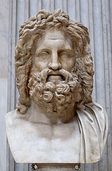 The Otricoli Zeus (Vatican Museum)
Anciently named Ocriculum, the Umbrian city concluded an alliance with Rome in 308 BC. The modern village lies on the site of the ancient town about two km north of the Roman relocation, which was moved down from the defensible position[1] probably at the end of the Republican era, in order to be closer to the curve of the Tiber and the Via Flaminia, which crossed the river here to enter Umbria. Its river port was the "oil port", signalling the olive culture that supported its economy. A pensor lignarius ("weigher of wood") noted in a recently unearthed inscription, identifies a trade in timber and perhaps firewood (Soprintendenza per i Beni Culturali).
Excavations on the Roman site in 1775 and following years led to the discovery of the baths, a theatre, a basilica and other buildings. In the baths were found a number of works of art, now in the Vatican, notably the mosaic pavement of the Sala della Rotonda, Museo Pio-Clementino, and the celebrated head of Zeus (illustration, left) and the head of Claudius, both also shown in the Sala della Rotonda.
A badly-eroded amphitheatre is still visible, but the other buildings have in the main been covered up again. Lack of consistent archaeological investigation has left the layout and extent of the Roman site unclear, though many works of art have been removed. Some finds are shown in the Antiquarium on the site.
Notes
- ^ The Roman site was not walled.
External links
- Official site of the comune of Otricoli
- Bella Umbria: Ocriculum
- Soprintendenza per i Beni Culturali, Otricoli - Parco archeologico
References
 This article incorporates text from a publication now in the public domain: Chisholm, Hugh, ed (1911). Encyclopædia Britannica (11th ed.). Cambridge University Press.
Umbria · Comuni of the Province of Terni Acquasparta · Allerona · Alviano · Amelia · Arrone · Attigliano · Avigliano Umbro · Baschi · Calvi dell'Umbria · Castel Giorgio · Castel Viscardo · Fabro · Ferentillo · Ficulle · Giove · Guardea · Lugnano in Teverina · Montecastrilli · Montecchio · Montefranco · Montegabbione · Monteleone d'Orvieto · Narni · Orvieto · Otricoli · Parrano · Penna in Teverina · Polino · Porano · San Gemini · San Venanzo · Stroncone · TerniCategories:- Cities and towns in Umbria
- Communes of the Province of Terni
- Hilltowns in Umbria


Wikimedia Foundation. 2010.