- Mayen
-
Mayen Old city hall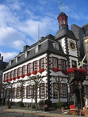

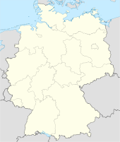
 MayenLocation of the town of Mayen within Mayen-Koblenz district
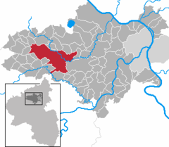
Coordinates 50°20′0″N 7°13′0″E / 50.333333°N 7.216667°ECoordinates: 50°20′0″N 7°13′0″E / 50.333333°N 7.216667°E Administration Country Germany State Rhineland-Palatinate District Mayen-Koblenz Lord Mayor Veronika Fischer (CDU) Basic statistics Area 58.04 km2 (22.41 sq mi) Elevation 230 m (755 ft) Population 18,627 (31 December 2010)[1] - Density 321 /km2 (831 /sq mi) Other information Time zone CET/CEST (UTC+1/+2) Licence plate MYK Postal code 56727 Area code 02651 Website www.mayen.de Mayen is a town in the Mayen-Koblenz District of the Rhineland-Palatinate Federal State of Germany, in the eastern part of the Volcanic Eifel Region. As well as the main town, there are five further settlements which are part of Mayen, they are: Alzheim, Kürrenberg, Hausen-Betzing, Hausen and Nitztal. Mayen is the administrative centre of the Vordereifel ‘Collective Municipality’, although is itself not part of the municipality.
Contents
Geography
To the west, as well as to the north and south-west, of Mayen is the country landscape of the Eifel. To the east, the landscape flattens out, running towards the Koblenz-Neuwied Basin, which itself can be divided into the northern section of Pellenz and the southern section of Maifeld. This area is also geographically considered to be part of the Eifel. Because of this, Mayen is often called ‘The Gateway to the Eifel’.
The small river Nette runs through the town, flowing from the Eifel towards Weißenthurm on the Rhine.
History
Even in Roman times, Mayen (lat. Megina) was an important economic centre. From the end of the 3rd Century up until the Middle Ages, potteries were established here, whose products made their way across Central Europe. An even older – prehistoric – use was found for the quarries in the nearby area; the basalt was used to make millstones and the tuff was used in the production of sarcophagi. These sarcophagi were found buried with significant glass artifacts (which are now displayed in the Genovevaburg Museum in Mayen).
The name Mayen probably comes from the name Megina. Records from as far back as 847 show this as a designation of the town, coming from the Celtic word ‘magos’ meaning field. In the 8th Century the legend of Genoveva of Brabant, names Mayen as the seat of government of Duke Siegfried of the Pfalz.
Mayen received its first official recognition in 1041, and was granted Town Status in 1291 from Rudolf I von Habsburg, at the same time as Bernkastel, Welschbillig, Montabaur and Saarburg. Mayen is possibly linked to the town of Maifeld, which lies a short distant to the south-east, since Mayen was called the capital of the Meiengau in the Middle Ages.
During the Second World War, in particular during the Air Attacks of 12 December 1944 and 2 January 1945, up to approximately 90% of the town was destroyed, and only after a special referendum was it decided to rebuild it.
Up until 1973, Mayen was the District Centre of the Mayen District (with number-plate code MY). After 1973, the district administration was moved to Koblenz and the District was renamed Mayen-Koblenz District with the new number-plate code of MYK; Koblenz kept its own code of KO.
Boroughs
Because of the Kommunalreform in 1970 four villages next to Mayen were incorporated. The four villages now belong officially to the town and became Boroughs of Mayen. Nowadays the Boroughs are still village-like and maintain most of the Agriculture of Mayen. The Boroughs are
- Alzheim (Population approx. 1300), to the south
- Hausen (Population approx. 1500), to the east, towards Koblenz
- Kürrenberg (Population approx. 1200), to the west, towards Nürburgring
- Nitztal (Population approx. 180), to the north, towards Schloss Bürresheim
The Population of Alzheim and Hausen is increasing in the last years, due to the creation of new residential areas.
Infrastructure
- Favourable location between A 61 (Cologne, Ludwigshafen) and A 48 (Trier, Koblenz).
- Train connection: the Trans Regio branch line goes from Andernach, which is on the Koblenz to Cologne route, to Kaisersesch in the Eifel, through Mayen Ost and, less frequently, through Mayen West.
- Regular (hourly) bus routes to/from Andernach, Neuwied and Koblenz, as well as westwards into the Eifel. The town is part of the Verkehrsverbund Rhein-Mosel (Rhine-Mosel Transport Network).
- Various shopping and business areas; several supermarkets from national chains; many clothes, sports, stationary and other shops; a cinema; various petrol stations; a large furniture store; a DIY store as well as building-supply stores. Most of these are located in a shopping area on the outskirts of the town, towards Koblenz.
- The town centre is very attractive and has a large pedestrian precinct.
- The town has its own hospital, the St Elisabeth Krankenhaus, and emergency services.
Industry
Basalt-, slate-, cardboard industry, machine-production, aluminium- and artificial material processing.
Sights
 Chapel
- Genovevaburg from the 13th Century, with the Eifel Museum and the Slate Mining Museum housed inside.
- St Clemens Parish Church with its twisted spire (symbol of the town, rebuilt in 1945)
- Herz-Jesu Church (built in 1911/12)
- Volcanic Information Station in the Vulkanpark (Volcanic Park).
- Nearby in the Nette Valley: Schloss Bürresheim, which appears as Castle Grunewald in 'Indiana Jones and the Last Crusade'.
- Swimming and leisure pool, with the longest hanging water slide in the world (see Guinness Book of Records).
Events
- Lukasmarkt: yearly fair in October with rides and amusements for a week, as well as two days where there is a livestock market (for which the fair was originally established).
- Burgfestspiele (Castle Festival Show): for several weeks in late spring, the courtyard of the castle is transformed into an open-air theatre, which is then used for various productions.
- Stein- und Burgfest (Stone and Castle Festival); a chance for local craftsmen and guilds to showcase their trade. Usually for two days towards in September.
Education
Mayen is home to the Fachhochschule für öffentliche Verwaltung (Training College for Public Administration), two Gymnasien (top-level secondary schools): the Megina Gymnasium and the Wirtschaftsgymnasium (Economics Grammar School); a Realschule (middle-level secondary school): the Albert-Schweizer-Realschule; two Hauptschulen (lower-level secondary school): Hinter Burg, St Veit; a Berufschule (vocational school); various Grundschulen (primary schools); two Förderschulen (schools for children with disabilities); a beekeeping school, and a stonemasonry school. The Bundeswehr (German Armed Forces) has a forces school at the Mayen Barracks, where troops are trained for how to deal with the media and psychological aspects to operation leading. This school is unique in Germany. Michigan State University has a summer program in Mayen
Mayen Personalities
- Karl Uller, (1872–1959), physicist
- Emmy Kreiten-Barido, (1894–1985) singer and mother of the martyred Karlrobert Kreiten
- Reinhard Saftig (Trainer of various teams from the German Bundesliga, including Bayern Munich, now Manager of Arminia Bielefeld)
- Mario Adorf (actor, author)
- Heinrich Alken (scuptor, painter)
- Christoph Friedrich Heinle (poet)
- Balthasar Krems (Inventor of the sewing machine)
- Winfried Schäfer (famous footballer and trainer)
- Hans-Ludwig Schilling (composer)
- Anne Spurzem (politician)
- Anton Woger (sculptor)
- Stephan Ackermann (bishop)
- Dominik Meffert (professional tennis player)
- Nadja Jennifer Maniotis (singer, actress)
- Jacques Loeb, 1859–1924, physiologist and biologist
- Leo Loeb, biologist
- Theodore Dreiser, American writer, son of an immigrant from Mayen
- Paul Dresser, American musician and songwriter, brother of Theodore Dreiser
Twin towns
Mayen’s twin towns are: Joigny in France, Godalming in England, Uherské Hradiště in the Czech Republic and Cyabingo in Rwanda.
References
- ^ "Bevölkerung der Gemeinden am 31.12.2010" (in German). Statistisches Landesamt Rheinland-Pfalz. 31 December 2010. http://www.statistik.rlp.de/fileadmin/dokumente/berichte/A1033_201022_hj_G.pdf.
External links
Acht · Alken · Andernach · Anschau · Arft · Baar · Bassenheim · Bell · Bendorf · Bermel · Boos · Brey · Brodenbach · Burgen · Dieblich · Ditscheid · Einig · Ettringen · Gappenach · Gering · Gierschnach · Hatzenport · Hausten · Herresbach · Hirten · Kalt · Kaltenengers · Kehrig · Kerben · Kettig · Kirchwald · Kobern-Gondorf · Kollig · Kottenheim · Kretz · Kruft · Langenfeld · Langscheid · Lehmen · Lind · Löf · Lonnig · Luxem · Macken · Mayen · Mendig · Mertloch · Monreal · Mülheim-Kärlich · Münk · Münstermaifeld · Nachtsheim · Naunheim · Nickenich · Niederfell · Niederwerth · Nörtershausen · Oberfell · Ochtendung · Pillig · Plaidt · Polch · Reudelsterz · Rhens · Rieden · Rüber · Saffig · Sankt Johann · Sankt Sebastian · Siebenbach · Spay · Thür · Trimbs · Urbar · Urmitz · Vallendar · Virneburg · Volkesfeld · Waldesch · Weiler · Weißenthurm · Weitersburg · Welling · Welschenbach · Wierschem · Winningen · Wolken
 Categories:
- Towns in Rhineland-Palatinate


Wikimedia Foundation. 2010.