- Demography of Greater Manchester
-
The demography of Greater Manchester is characterised by a number of trends recorded amongst its multicultural agglomoration of 2.55 million people, as part of census returns and other systems of measurement used in the English metropolitan county.
Greater Manchester is the third most populous, and seventh most densely populated, county in England.
Compared against the demography of the United Kingdom, Greater Manchester has significant ethnic minority population comprising 11.09% of the total population.[1]
Contents
Key statistics
Greater Manchester Compared[2][3] UK Census 2001(ethnicity, 2005 estimates[4]) Greater Manchester North West (Region) England Total population 2,547,700 6,729,764 49,138,831 Foreign born 7.2% 5.0% 9.2% White 88.9% 92.9% 89.1% Asian 6.5% 4.1% 5.3% Black 1.7% 1.0% 2.7% Christian 74% 78% 72% Muslim 5.0% 3.0% 3.1% Hindu 0.7% 0.4% 1.1% No religion 11% 10% 15% Over 75 years old 7.0% 7.4% 7.5% Unemployed 3.5% 3.6% 3.3% Compared against the demography of England, Greater Manchester's demographics are broadly inline with national averages on many topics. In terms of ethnicity, its Asian and British Asian population is considerably above the regional and national averages, as is the portion of residents who identify as Muslim.
Population change
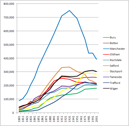
 The population of Greater Manchester has increased from around 328 thousand in 1801, to 2.5 million in 2001. It was at its peak in 1971, at 2.7 million.
Below is a table outlining population totals of the area for every ten years since 1801. Pre-1974 statistics were gathered from local government areas that now comprise Greater Manchester.
Year Population Year Population Year Population 1801 328,609 1871 1,590,102 1941 2,693,775 1811 409,464 1881 1,866,649 1951 2,688,987 1821 526,230 1891 2,125,318 1961 2,699,711 1831 700,486 1901 2,357,150 1971 2,729,741 1841 860,413 1911 2,617,598 1981 2,575,441 1851 1,037,001 1921 2,660,088 1991 2,569,700 1861 1,313,550 1931 2,707,070 2001 2,482,352 Source: A Vision of Britain through Time.[5] Boroughs
 Manchester has always been vastly more populous than any other district of Greater Manchester.
According to the 2001 national census, Greater Manchester's ten metropolitan boroughs, the City of Manchester is the most populous with a population of 441,200, whilst the Metropolitan Borough of Bury is the least populous with 183,500. The City of Manchester's population in 2011 is predicted at just under half-a-million at 498,000[6] and is the fastest growing of any British city.[6]
In terms of districts by ethnic diversity, the City of Manchester is ranked the highest in Greater Manchester (34th in England), followed by the metropolitan boroughs of Oldham (45th in England), Rochdale (53rd in England), and Trafford (68th in England). Wigan is the least ethnically diverse borough in the county, and 274th in England.
The Metropolitan Borough of Oldham is the borough with the highest proportion of people under fifteen years of age.[7] Almost 12% of people in the Metropolitan Borough of Oldham are of South Asian heritage, the highest proportion of a borough of Greater Manchester.[7]
With greater affluence, a recent trend has seen the some of the Pakistani community move out of the inner city into more spacious suburbs. In South Manchester this means that they have been moving from Longsight/Levenshulme to more suburban areas such as Cheadle, Chorlton and Heaton Mersey. Due to some of these suburbs having high house prices, the Pakistanis who live there tend to be of later generation with successful/professional careers. The inner city areas that are being left are generally filled with newer immigrants from places like Iran,Afghanistan and Poland.[2] [3][4][5]
Rank Metropolitan district Population in 2001 1 Manchester 441,200 2 Wigan 306,700 3 Stockport 281,600 4 Bolton 265,400 5 Oldham 219,200 6 Salford 216,400 7 Tameside 214,100 8 Trafford 213,200 9 Rochdale 206,400 10 Bury 183,500 Ethnicity
2005 estimates of ethnic groups in Greater Manchester.[4]
- White - 2,261,200 (88.91%)
- White British - 2,175,100 (85.52%)
- White Irish - 38,800 (1.53%)
- White Other - 47,200 (1.86%)
- Mixed Race - 39,700 (1.56%)
- White and Black Caribbean - 14,400 (0.57%)
- White and Black African - 6,000 (0.24%)
- White and South Asian - 10,900 (0.43%)
- Mixed Other - 8,100 (0.32%)
- South Asian - 165,700 (6.52%)
- Indian - 44,500 (1.75%)
- Pakistani - 84,300 (3.31%)
- Bangladeshi - 23,600 (0.93%)
- South Asian Other - 13,300 (0.52%)
- Black - 43,600 (1.71%)
- Black Caribbean - 17,400 (0.68%)
- Black African - 22,300 (0.88%)
- Black Other - 3,800 (0.15%)
- East Asian and Other - 33,300 (1.31%)
References
- ^ [1].
- ^ United Kingdom Census 2001 (2007-01-17). "2001 Census; Key facts sheets". manchester.gov.uk. Archived from the original on 2007-10-07. http://web.archive.org/web/20071007163725/http://www.manchester.gov.uk/planning/studies/census/keyfacts/. Retrieved 2007-07-10.
- ^ United Kingdom Census 2001 (2001). "Greater Manchester (Health Authority)". neighbourhood.statistics.gov.uk. http://neighbourhood.statistics.gov.uk/dissemination/LeadPage.do?pageId=1003&tc=1184106419348&a=7&b=789833&c=M7+4FU&d=14&e=6&f=90&g=353838&i=1x1003x1004x1005&l=179&o=1&m=0&enc=1. Retrieved 2007-07-10.
- ^ a b Lead View Table
- ^ A Vision of Britain through time. "Greater Manchester Met.C: Total Population". http://www.visionofbritain.org.uk/data_cube_table_page.jsp?data_theme=T_POP&data_cube=N_TPop&u_id=10056925&c_id=10001043&add=N. Retrieved 2007-04-06.
- ^ a b Walsh, Pamela (2 July 2011). "Mapped: Population hits a high as thousands flock to Manchester". Manchester Evening News. http://menmedia.co.uk/manchestereveningnews/news/s/1425494_mapped-population-hits-a-high-as-thousands-flock-to-manchester. Retrieved 2 July 2011.
- ^ a b "BOROUGH PROFILE: Oldham". Greater Manchester Fire and Rescue Service. 2002. Archived from the original on 2007-05-18. http://web.archive.org/web/20070518102819/http://www.manchesterfire.gov.uk/irmp/draft_page.asp?id7=3&id8=2&id13=13&id43=5A. Retrieved 2007-02-10.
Ceremonial county of Greater Manchester Statutory City Region - Greater Manchester Combined Authority
- Greater Manchester Statutory City Region
Metropolitan districts Major settlements - Altrincham
- Ashton-in-Makerfield
- Ashton-under-Lyne
- Atherton
- Audenshaw
- Blackley
- Bolton
- Bury
- Cadishead
- Chadderton
- Clifton
- Denton
- Droylsden
- Dukinfield
- Eccles
- Failsworth
- Farnworth
- Golborne
- Heywood
- Hindley
- Horwich
- Hyde
- Irlam
- Kearsley
- Leigh
- Littleborough
- Manchester
- Middleton
- Milnrow
- Mossley
- Oldham
- Partington
- Pendlebury
- Prestwich
- Radcliffe
- Ramsbottom
- Rochdale
- Royton
- Sale
- Salford
- Shaw and Crompton
- Stalybridge
- Stockport
- Stretford
- Swinton
- Tottington
- Tyldesley
- Urmston
- Walkden
- Westhoughton
- Whitefield
- Wigan
- Worsley
See also: List of civil parishes in Greater Manchester
Rivers Topics - Castles
- Churches
- Demography
- Football clubs
- Geography
- Grade I listed buildings
- Grade II* listed buildings
- Museums
- Parliamentary constituencies
- People
- Places
- Schools
- SAMs
- SSSIs
Categories:- Geography of Greater Manchester
- Demographics of England
- White - 2,261,200 (88.91%)

Wikimedia Foundation. 2010.