- River Churni
-
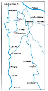
 Diagram of River Churni's evolution
River Churni is a river in the Nadia district, West Bengal, India.
Course
The river flows through Shibnivas, Hanskhali, Birnagar, Aranghata, Ranaghat, and finally joins River Bagirathi near Chakdaha. Its length is almost 56 km. The river's origin is at 23.40 North, 88.70 East and its confluence is at 23.13 North, 88.50 East.
Geology
The river is in its lower course of flow. Riverbed is dumped with sediment, and full of small, often submerged river islands.
History
River Churni was most probably an artificial canal, not a true river. Local history says, during 17th Century, the King of Nadia (that time Nadia was a kingdom, now a district of West Bengal) was Maharajah Krishna Chandra. River Churni was dug at his orders as a moat against the Bargee-s or Bergir-s of Maharashtra. At that time, there was another important river here. Its name was Anjana. It originated from Jalangi River, and confluenced with River Bhagirathi. A distributary emerged from Anjana near Jatrapur (Yatrapur), and confluenced in Ichamati. At that time the lower part of Mathabhanga was known as Ichamati, same as now. The flux of Anjana and the distributary increased with water of the canal. Later, the distributary was filled up artificially, and alluvial sedimentation jammed the upper part of Anjana. The canal, and the lower part of Anjana is today’s Churni. However in Renel's map (1760s) there is no trace of Churni.
Only 70 years ago, in the 1930s, it was the major trade route inside undivided Bengal. Now, the river has lost its navigability.
Categories:- Rivers of West Bengal

Wikimedia Foundation. 2010.