- Clovis, California
-
City of Clovis — City — Pollasky Avenue, Old Town Clovis Location in Fresno County and the state of California
Coordinates: 36°49′31″N 119°42′11″W / 36.82528°N 119.70306°WCoordinates: 36°49′31″N 119°42′11″W / 36.82528°N 119.70306°W Country  United States
State  California
County Fresno Government – Mayor Jose Flores – Mayor Pro Tem Lynne Ashbeck – Senate Tom Berryhill (R) – Assembly Linda Halderman (R) – U. S. Congress Devin Nunes (R) Area[1] – Total 23.278 sq mi (60.289 km2) – Land 23.278 sq mi (60.289 km2) – Water 0 sq mi (0 km2) 0% Elevation 361 ft (110 m) Population (2011) – Total 97,218 – Density 4,176.4/sq mi (1,612.5/km2) Time zone PST (UTC-8) – Summer (DST) PDT (UTC-7) ZIP codes 93611-93613 & 93619 Area code(s) 559 FIPS code 06-14218 GNIS feature ID 1656303 Website http://www.ci.clovis.ca.us Clovis is a city in Fresno County, California, United States, northeast of Fresno. The population is estimated to be 97,218 as of September, 2011. Clovis is located 6.5 miles (10.5 km) northeast of downtown Fresno,[2] at an elevation of 361 feet (110 m).[3]
Contents
History
The city of Clovis began as a freight stop along the San Joaquin Valley Railroad. Organized on January 15, 1890 by Fresno businessmen Thomas E. Hughes, Fulton Berry, Gilbert R. Osmun, H.D. Colson, John D. Gray, and William M. Williams, in partnership with Michigan railroad speculator Marcus Pollasky, the SJVRR began construction in Fresno on July 4, 1891 and reached the farmlands of Clovis Cole and George Owen by October of that year. The railroad purchased right-of-way from both farmers, half from each - the east side from Cole and the west side from Owen - and ran tracks up the borderline between the two properties. The railroad agreed to establish a station on the west side of the tracks and to call it "Clovis". It may be worth noting that the Clovis station, after which the town was named, was positioned on the Owen side of the track....
Cole and Owen later sold land to the person of Marcus Pollasky for development of a townsite. Fresno civil engineer Ingvar Tielman mapped the townsite on behalf of Marcus Pollasky and recorded the townsite map on December 29, 1891. The original townsite featured streets named for the officers and principal investors of the railroad – (Benjamin) Woodworth, (Marcus) Pollasky, Fulton (Berry), (Thomas) Hughes, (Gerald) Osmun, and (O. D.) Baron. The townsite, named Clovis by its owner Marcus Pollasky, was laid out on what was originally Owen's land.
The railroad was completed as far as the town of Hamptonville (now Friant) on the banks of the San Joaquin River, just 26 miles (42 km) from its point of origin in Fresno. Following a celebration of the completion of tracklaying on the Wednesday before Thanksgiving of 1891, the railroad began official operation in January 1892.
The myth persists, even today, that the SJVRR was eventually to cross the Sierra and connect with an existing major railroad to create a transcontinental link. Articles of Incorporation for the San Joaquin Valley Railroad indicate that the corporation intended to build a maximum of 100 miles of track, including sidings and spurs, through the agricultural acreage east of Fresno, then north to the timber and mineral resources of the Sierra foothills. The transcontinental wish seems to have been only naive conjecture on the part of those outside the project.
The first year of operation of the railroad coincided with the beginnings of a deep national economic decline. Farmers were unable to get profitable return on their crops, banks and railroads failed nationwide. The SJVRR was unable to generate sufficient revenues to pay its debt, was leased to the Southern Pacific Railroad and subsequently bought by SPRR in 1893. By reducing the railroad's schedule of operation and trimming costs, the Southern Pacific was able to turn a small profit in the first years after its acquisition.
At the same time that the railroad was being planned, a group of Michigan lumbermen began acquiring thousands of acres of timber in the Sierra Nevada about 75 miles northeast of Fresno. A dam was built across Stevenson Creek to create a lake that would enable them to move freshly cut timber to a mill beside the lake. They then constructed a 42-mile (68 km), 25-foot (7.6 m) high, V-shaped flume that started at the foot of the dam. As lumber was rough-cut at the mill, it was loaded into the flume and propelled by water to a planing mill east of the Clovis railroad station. The lumber mill and yard had its own network of rails to move lumber around the yard and to connect with the SJVRR just south of Clovis station.
The completion in 1894 of the lumber flume and commencement of mill operations provided the impetus for further development of the area around the Clovis Station. The town began to take shape as lumber yard employees built homes close to their employment. Service businesses, churches, and schools became necessary, and the town was begun. Clovis's first post office opened in 1895.[2] An 1896 newspaper article describes the town as having a population approaching 500 citizens.
Clovis was incorporated as a city in February 1912. Principal streets in the town center are still named for the railroad's officers, except for Fulton Street, which was later named Front Street, then Main Street, and is now Clovis Avenue.
The lumber mill burned in 1914 and was not rebuilt. The grounds are now occupied by Clark Intermediate School and the Clovis Rodeo Grounds.
The last surviving structure built by the railroad is a depot now located near the site of the original Clovis Station. It has been long believed that this depot originally stood on the Tarpey Ranch south of the intersection of Ashlan and Clovis Avenues. Evidence has surfaced that the depot may have originated further south on the Las Palmas vineyards. In 1999 it was moved to its present location in the town's center, at the northeast corner of Clovis Avenue and Fourth Street, and was restored by the Clovis Big Dry Creek Historical Society in partnership with local businesses and contractors.
Clovis has a long history as a western town known for its slogan, "Clovis - A Way of Life." Since 1914, the Clovis Rodeo has been held on the last weekend in April, with a parade on Saturday morning, followed by the rodeo that afternoon and all day Sunday. Also contributing to the "Clovis way of life" are a number of street festivals, including Big Hat Days, ClovisFest, and the weekly Friday Night Farmer's Market held between mid-May and mid-September every year.
Many buildings in the town core have been renovated. Older storefronts on Clovis Avenue, the main street running through town, have been restored and new buildings have been designed with facades that resemble those found in the early 20th century. The historic center, with its fresh new look, has been reborn as "Old Town Clovis."
Geography
According to the United States Census Bureau, the city has a total area of 23.28 square miles (60.29nbsp;km²), all of it land.
Clovis is situated midway between Los Angeles and San Francisco, bordering Fresno, in the agriculturally rich San Joaquin Valley. Lying at the foot of the Sierra Nevada Mountain Range, which includes Yosemite, Kings Canyon, and Sequoia National Parks, Clovis has been known as "Gateway to the Sierras" since its incorporation in 1912.
The formation of alluvial fans in this part of the San Joaquin Valley has led to a rather flat regional geography. The Clovis area has active and potentially active seismic fault zones.[4] The elevation of Clovis is approximately 355 feet (108 m) above mean sea datum[5] According to the Flood Hazard Boundary Map produced by the U.S. Department of Housing and Urban Development, part of Clovis is within the 100-year flood zone, such as some of the area near the Clovis Towne Center. The groundwater flow in Clovis is generally to the southwest.
Clovis, California Climate chart (explanation) J F M A M J J A S O N D 2.254382.161412.266450.874480.483550.2916109766095650.389600.778521.163421.35337Average max. and min. temperatures in °F Precipitation totals in inches Source: Weather.com / NWS Metric conversion J F M A M J J A S O N D 551235416556197192399.928135.833160.336190.335186.632161726112817634123Average max. and min. temperatures in °C Precipitation totals in mm Economy
Top employers
According to the City's 2009 Comprehensive Annual Financial Report,[6] the top employers in the city are:
# Employer # of Employees 1 Clovis Unified School District 5,300 2 Pelco 2,100 3 Clovis Community Medical Center 979 4 City of Clovis 631 5 Target 430 6 Alorica 339 7 Wal-Mart 332 8 AT&T 260 9 Save Mart 247 10 Costco 220 Climate
Clovis, like much of Central California has year-round pleasant weather:
-On average, the warmest month is July.
-The highest recorded temperature was 115°F in 1905.
-On average, the coolest month is December.
-The lowest recorded temperature was 17°F in 1913.
-The maximum average precipitation occurs in March.Demographics
2010
The 2010 United States Census[7] reported that Clovis had a population of 95,631. The population density was 4,108.2 people per square mile (1,586.2/km²). The racial makeup of Clovis was 67,758 (70.9%) White, 2,618 (2.7%) African American, 1,320 (1.4%) Native American, 10,233 (10.7%) Asian, 218 (0.2%) Pacific Islander, 8,857 (9.3%) from other races, and 4,627 (4.8%) from two or more races. Hispanic or Latino of any race were 24,514 persons (25.6%).
The Census reported that 95,243 people (99.6% of the population) lived in households, 130 (0.1%) lived in non-institutionalized group quarters, and 258 (0.3%) were institutionalized.
There were 33,419 households, out of which 13,718 (41.0%) had children under the age of 18 living in them, 17,975 (53.8%) were opposite-sex married couples living together, 4,554 (13.6%) had a female householder with no husband present, 1,889 (5.7%) had a male householder with no wife present. There were 1,985 (5.9%) unmarried opposite-sex partnerships, and 198 (0.6%) same-sex married couples or partnerships. 7,008 households (21.0%) were made up of individuals and 2,721 (8.1%) had someone living alone who was 65 years of age or older. The average household size was 2.85. There were 24,418 families (73.1% of all households); the average family size was 3.32.
The population was spread out with 26,851 people (28.1%) under the age of 18, 9,572 people (10.0%) aged 18 to 24, 25,542 people (26.7%) aged 25 to 44, 23,559 people (24.6%) aged 45 to 64, and 10,107 people (10.6%) who were 65 years of age or older. The median age was 34.1 years. For every 100 females there were 93.2 males. For every 100 females age 18 and over, there were 89.5 males.
There were 35,306 housing units at an average density of 1,516.7 per square mile (585.6/km²), of which 20,804 (62.3%) were owner-occupied, and 12,615 (37.7%) were occupied by renters. The homeowner vacancy rate was 2.3%; the rental vacancy rate was 6.4%. 60,767 people (63.5% of the population) lived in owner-occupied housing units and 34,476 people (36.1%) lived in rental housing units.
2000
As of the census[8] of 2000, there were 68,468 people, 24,347 households, and 17,675 families residing in the city. The population density was 4,000.2 people per square mile (1,544.1/km²). There were 25,250 housing units at an average density of 1,475.2 per square mile (569.5/km²). The racial makeup of the city was 75.8% White, 1.9% Black or African American, 1.5% Native American, 6.5% Asian, 0.2% Pacific Islander, 9.5% from other races, and 4.6% from two or more races. 20.3% of the population were Hispanic or Latino of any race.
There were 24,347 households out of which 41.7% had children under the age of 18 living with them, 54.4% were married couples living together, 13.2% had a female householder with no husband present, and 27.4% were non-families. 22.3% of all households were made up of individuals and 8.1% had someone living alone who was 65 years of age or older. The average household size was 2.79 and the average family size was 3.29.
In the city the population was spread out with 30.7% under the age of 18, 9.2% from 18 to 24, 30.4% from 25 to 44, 20.4% from 45 to 64, and 9.4% who were 65 years of age or older. The median age was 33 years. For every 100 females there were 92.3 males. For every 100 females age 18 and over, there were 88.2 males.
The median income for a household in the city was $42,283, and the median income for a family was $50,859. Males had a median income of $39,630 versus $28,072 for females. The per capita income for the city was $18,690. About 7.6% of families and 10.6% of the population were below the poverty line, including 13.1% of those under age 18 and 7.1% of those age 65 or over.
Clovis image gallery
-

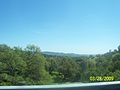
Gateway to Sierra Nevada
-

Herndon Ave.
-
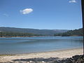
Bass lake
-
Coarsegold
Education
Clovis Unified School District
Main article: Clovis Unified School District- Elementary schools
- Cedarwood, Century, Clovis, Cole, Copper Hills, Cox, Dry Creek, Fancher Creek, Fort Washington, Freedom, Fugman, Garfield, Gettysburg, Jefferson, Liberty, Lincoln, Maple Creek,Miramonte, Mountain View, Nelson, Pinedale, Red Bank,
Reagan Elementary, Riverview, Sierra Vista, Tarpey, Temperance-Kutner, Valley Oak, Weldon Harold L. Woods, Bud Rank
- Middle schools
- Clark Intermediate, Kastner Intermediate, Alta Sierra Intermediate, Reyburn Intermediate, Granite Ridge Intermediate
- High schools
- Buchanan High School, Clovis East High School, Clovis High School, Clovis West High School, Clovis North High School, Enterprise High School, Excel High School Gateway High School,
- Area Colleges
Public libraries
Fresno County Public Library operates the Clovis Regional Library.[9]
Community-based organizations (nonprofits)
- Clovis Amateur Radio Pioneers, an amateur radio club that serves Clovis and the Central Valley.
Notable residents
- Aaron Hill, American actor, best known for his work on the ABC Family TV show, Greek
- Chris Colfer, American singer and actor, best known for portraying the role of Kurt Hummel on Glee.[10]
- Daryle Lamonica, quarterback for the Buffalo Bills and the Oakland Raiders
- Garrett Olson, a current pitcher for the Seattle Mariners attended Buchanan High.
- John Taylor, a former wide receiver for the San Francisco 49ers
- Zack Follett, current linebacker for the Detroit Lions
See also
References
- ^ U.S. Census
- ^ a b Durham, David L. (1998). California's Geographic Names: A Gazetteer of Historic and Modern Names of the State. Quill Driver Books. p. 1018. ISBN 9781884995149.
- ^ U.S. Geological Survey Geographic Names Information System: Clovis, California
- ^ Phase I Environmental Site Assessment, Clovis Towne Center, Clovis, California, Earth Metrics Inc report 10283, October, 1989
- ^ U.S. Geological Survey, Clovis, California, 7.5 Minute Quadrangle, 1964, (photorevised 1972).
- ^ City of Clovis CAFR
- ^ All data are derived from the United States Census Bureau reports from the 2010 United States Census, and are accessible on-line here. The data on unmarried partnerships and same-sex married couples are from the Census report DEC_10_SF1_PCT15. All other housing and population data are from Census report DEC_10_DP_DPDP1. Both reports are viewable online or downloadable in a zip file containing a comma-delimited data file. The area data, from which densities are calculated, are available on-line here. Percentage totals may not add to 100% due to rounding. The Census Bureau defines families as a household containing one or more people related to the householder by birth, opposite-sex marriage, or adoption. People living in group quarters are tabulated by the Census Bureau as neither owners nor renters. For further details, see the text files accompanying the data files containing the Census reports mentioned above.
- ^ "American FactFinder". United States Census Bureau. http://factfinder.census.gov. Retrieved 2008-01-31.
- ^ "Clovis Regional Library." Fresno County Public Library. Retrieved on June 27, 2010.
- ^ "Chris Colfer's Gaga Gaffe". The Advocate. http://www.advocate.com/News/Daily_News/2010/04/29/Chris_Colfers_Gaga_Gaffe/. Retrieved October 25, 2011.
External links
- Clovis Museum
- Clovis Chamber of Commerce
- City of Clovis official website
- Clovis Independent
- Clovis Rodeo Association
- Old Town Clovis website
Municipalities and communities of Fresno County, California Cities 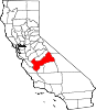
CDPs Auberry | Big Creek | Biola | Bowles | Calwa | Cantua Creek | Caruthers | Centerville | Del Rey | Easton | Fort Washington | Friant | Lanare | Laton | Malaga | Mayfair | Minkler | Monmouth | Old Fig Garden | Raisin City | Riverdale | Shaver Lake | Squaw Valley | Sunnyside | Tarpey Village | Three Rocks | Tranquillity | West Park
Unincorporated
communitiesAlder Springs | Arbios | Avocado | Balch Camp | Barstow | Benito | Big Bunch | Biola Junction | Bretz Mill | Broadview Farms | Burness | Burrel | Calflax | Camden | Cameo | Camp Sierra | Cecile | Cedar Crest | Cedar Grove | Cedarbrook | Cella | Chaney Ranch | Cincotta | Clint | Clotho | Conejo | Crabtree | Cromir | Deer Crossing | Dinkey Creek | Dora Belle | Dunlap | Edmiston | Elk | Elm View | Etheda Springs | Figarden | Five Points | Floyd | Giffen Cantua Ranch | Glorietta | Goldleaf | Goodmill | Gordon | Gravesboro | Helm | Herndon | Highway City | Hoffman Point | Hub | Hume | Hume Station | Humphreys Station | Huntington Lake | Ingle | Ivesta | Jamesan | Kanawyers | La Jolla Ranch | Lacjac | Lakeshore | Lerona | Levis | Locans | Lone Star | Marshall Junction | Mathews Mill | Mattei | Meadow Lakes | Mercey Hot Springs | Miley | Miramonte | Mono Hot Springs | Murietta Farm | Muscatel | Navelencia | New Auberry | Ockenden | Old Bretz Mill | Oleander | Ora | Oro Loma | Oxalis | Panoche Junction | Parkfield Junction | Piedra | Pilibos Ranch | Pinehurst | Pineridge | Prather | Pratton | Raco | Riverbend | Rock Haven | Rodgers Crossing | Rolinda | Sawmill Flat | Schilling | Shaver Lake Heights | Sierra Cedars | Sierra Sky Park | Snow Bend | Tarpey | Tollhouse | Trimmer | Turk | Uva | Vanguard | Wahtoke | Westhaven | Westside | Wildflower | Wineland | Wolf | Wood Ranch | Zediker
Indian
reservationsBig Sandy Rancheria | Cold Springs Rancheria | Table Mountain Rancheria
Ghost towns Andrews | Barton | Bender | Bridge | Bronge | Butler | Cadogan | Caldwell | Carlile | Carmelita | Coalinga Mineral Springs | Collins | Darwin | Dathol | Deseret | Dickerson | El Prado | Elkhorn Station | Eshel | Everts | Fargo | Fort Camp | Fresno Beach | Fresno City | Fruitvale | Garfield | Granz | Hawthorne's Station | Hayes | Kelso | Kingriver | Kingston | La Libertad | Last | Leroy | Letcher | Lillis | Marshall Station | McKenzie Spring | McMullin | Mendota Station | Millerton | Mountain Rest | Nares | Nevills | Oakhurst | Oleander | Peteras Mill | Pinedale | Pool's Ferry | Pool's Fort | Poso de Chane | Portal | Pueblo de las Juntas | Rancho de los Californios | Reka | Riverview | Robinson | Rogers | Rugg | Sanders | Sentinel | Sharpville | Shaver | Shipp | Smith's Ferry | Sparkville | Tarn | Temperance | Thermal | Tisechu | Vanris | Vino | Warsaw
Categories:- Incorporated cities and towns in California
- Cities in Fresno County, California
- Clovis, California
- Populated places established in 1890
-


Wikimedia Foundation. 2010.