- Tehachapi, California
Infobox Settlement
official_name = Pagename
other_name =
native_name =
nickname = The Land of Four Seasons
settlement_type =City
motto =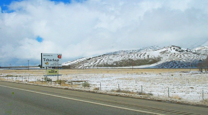
imagesize =
image_caption = Looking northwest along Route 58 in Tehachapi after a light dusting of snow
flag_size =
image_
seal_size =
image_shield =
shield_size =
image_blank_emblem =
blank_emblem_size =
flag_size =
image_
seal_size =
image_shield =
shield_size =
image_blank_emblem =
blank_emblem_size =
mapsize = 250x200px
map_caption = Location of Tehachapi, California
mapsize1 =
map_caption1 =
pushpin_
pushpin_label_position =
pushpin_map_caption =
pushpin_mapsize =
subdivision_type = Country
subdivision_name =United States
subdivision_type1 = State
subdivision_name1 =California
subdivision_type2 = County
subdivision_name2 = Kern
subdivision_type3 =
subdivision_name3 =
subdivision_type4 =
subdivision_name4 =
government_type =
leader_title = Mayor
leader_name = Deborah Hand
leader_title1 =
leader_title1 = Senate
leader_name1 =Roy Ashburn (R)
leader_title2 = Assembly
leader_name2 =Bill Maze (R)
leader_title3 = U. S. Congress
leader_name3 = Kevin McCarthy (R)
leader_title4 =
leader_name4 =
established_title = Founded
established_date = 1876
established_title2 =
established_date2 =
established_title3 =
established_date3 =
area_magnitude =
unit_pref =
area_footnotes =
area_total_km2 = 24.8
area_land_km2 = 24.8
area_water_km2 = 0.0
area_total_sq_mi = 9.6
area_land_sq_mi = 9.6
area_water_sq_mi = .1
area_water_percent =
area_urban_km2 =
area_urban_sq_mi =
area_metro_km2 =
area_metro_sq_mi = 228.2
population_as_of = est. 2005
population_footnotes =
population_note =
population_total = 16,442
population_density_km2 = 441.7
population_density_sq_mi = 1144.0
population_metro = 36,690
population_density_metro_km2 =
population_density_metro_sq_mi =
population_blank1_title =
population_blank1 =
timezone = PST
utc_offset = -8
timezone_DST = PDT
utc_offset_DST = -7
latd = 35 |latm = 24 |lats = 21 |latNS = N
longd = 119 |longm = 01 |longs = 07 |longEW = W
elevation_footnotes =
elevation_m = 1210
elevation_ft = 3969
postal_code_type = ZIP code
postal_code = 93561
area_code = 661
blank_name = FIPS code
blank_info = 06-78092
blank1_name = GNIS feature ID
blank1_info = 1652798
website = [http://www.tehachapi.com/ City of Tehachapi Chamber Official Website]
footnotes = Tehachapi (IPAEng|təˈhætʃəpi) is a city incorporated in 1909 located in its namesakeTehachapi Mountains between Bakersfield and Mojave inKern County, California . The area is known for itsTehachapi Loop , electricity generatingwind turbines , proximity toEdwards Air Force Base , and excellent environment forgliding . A maximum security prison, theCalifornia Correctional Institution , also known as the Tehachapi State Prison, has long been located in the area. The population was 10,957 at the 2000 census. As of 2006 the total population of the Tehachapi area is estimated at 35,000 including surrounding areas. The populated places in the vicinity of the incorporated City of Tehachapi include Golden Hills, Old Town, Bear Valley Springs, Stallion Springs, Oak Knolls, Alpine Forest Park, Mountain Meadows, Cummings Valley, Brite Valley, Old West Ranch, Sand Canyon, Keene, and Hart Flat. The Greater Tehachapi Area has a convert|25|mi|km|0|sing=on radius. Tehachapi's Elevation ranges from convert|3969|ft|m to 7,981 feet (Double Mountain).The headquarters of the United Farm Workers, a national farmworker's organization that was founded and led by
Cesar Chavez , is located convert|10|mi|km|-1 to the west at Keene. In April 2004 the [http://www.chavezfoundation.org/files/pdf/ChavezCenterOpens.pdf National Chavez Center] opened to the public.The area in and around the city is also known for its
apple orchards, though these have decreased in recent decades. Its four seasons climate and rural ambiance has of late attracted retirees to the city. The late actorJack Palance of "City Slickers " fame lived on a ranch just north of the Stallion Springs area.While less than convert|120|mi|km|-1 to the north-east of Los Angeles, Tehachapi maintains a distinctively rural atmosphere. Currently, there are only five traffic signals within or near the city limits. Ranches with horses as well as homes on large areas are common in the areas surrounding the city of Tehachapi. In addition, a number of flora and fauna reside in the area and include the California Poppy (state flower), quail (state bird), Mojave green rattlesnake, mountain lion (cougar), bobcat, deer, and wild boar to name just a few.
Migrations of turkey vultures use the Tehachapi Pass, and are counted annually by the [http://www.tmbc.info/info.html Tehachapi Mountains Birding Club.] This annual count is the inspiration for the TMBC club song.
Tehachapi Municipal Airport is rapidly becoming a favorite stop for a "$100 Hamburger " run. Also, fuel prices for both Jet A and 100LL are consistently lower than surrounding airports. Fact|date=November 2007Mountain Valley Airport also in Tehachapi is the site of glider rides and instruction, well-situated to take advantage of good soaring lift conditions from the mountains.Area history
Tehachapi was preceded by a settlement a few miles west of it called Williamsburg or "Tehichipa" which was in existence in the 1870s. After the Southern Pacific (SP) railroad (now merged into the
Union Pacific ) established its line through the mountains in 1876 Williamsburg saw its business taken away by the SP's newer location, eventually called Tehachapi Summit. Later its name was shortened to simply Tehachapi. The original SP railroad depot helped start the beginning of the downtown core. It is now on theNational Register of Historic Places and was the oldest building built in downtown Tehachapi until it burnt down at the end of June 2008. The building had been in the final stages of becoming a museum. Police have identified two men who set the building on fire with fireworks. [cite news | title = Depot fire caused by two men shooting off bottle rockets | url = http://www.tehachapinews.com/home/ViewPost/65302 | publisher = "Tehachapi News " | accessdate = 2008-07-10 ]The limestone mine and cement plant at Monolith, located northeast of the city, has been in operation since 1908. Cement from this operation helped build such engineering works as the 1913
Los Angeles Aqueduct —its first project—as well as the massiveHoover Dam dedicated for use in 1936.The
Dust Bowl migrants—known regionally here asOkie s and made famous byJohn Steinbeck 's "The Grapes of Wrath " came through the area on their way to the southernSan Joaquin Valley , especially in and around Bakersfield, at the time of the 1930sGreat Depression . In fact, Tehachapi is directly referenced in "The Grapes of Wrath ".On
July 21 ,1952 Tehachapi was devastated by a magnitude 7.5 (Richter scale)earthquake ( [http://earthquake.usgs.gov/regional/states/events/1952_07_21.php USGS] , [http://www.data.scec.org/chrono_index/kerncoun.html SCEC] ) on the little knownWhite Wolf fault . Unreinforcedbrick buildings resulted in major building destruction at that time, but have now long since been outlawed in California building codes.The origin of the name Tehachapi is in dispute. Possibilities include Native American words expressing:
* sweetwater andacorns (from the area's manyoak trees)
* windy place* hard climb (from Kawaiisu ~ Nuwa word "tihachipia" according to [http://www.parks.ca.gov/default.asp?page_id=610 Tomo-Kahni Resource Center] )
Geography
Tehachapi is located at coor dms|35|7|43|N|118|26|56|W|city (35.128558, -118.448899)GR|1.
According to the
United States Census Bureau , the city has a total area of 9.6 square miles (24.8 km²), of which, 9.6 square miles (24.8 km²) of it is land and 0.10% is water.Demographics
As of the
census GR|2 of2000 , there are 10,957 people, 2,533 households, and 1,709 families residing in the city. Thepopulation density is 1,144.0 people per square mile (441.6/km²). There are 2,914 housing units at an average density of 304.2/sq mi (117.4/km²). The racial makeup of the city is 57.17% White, 13.80% Black or African American, 1.35% Native American, 0.74% Asian, 0.16% Pacific Islander, 23.82% from other races, and 2.97% from two or more races. 32.70% of the population are Hispanic or Latino of any race.There are 2,533 households out of which 35.6% have children under the age of 18 living with them, 47.5% are married couples living together, 14.3% have a female householder with no husband present, and 32.5% are non-families. 28.8% of all households are made up of individuals and 13.5% have someone living alone who is 65 years of age or older. The average household size is 2.59 and the average family size is 3.19.
In the city the population is spread out with 18.5% under the age of 18, 12.9% from 18 to 24, 42.7% from 25 to 44, 16.5% from 45 to 64, and 9.4% who are 65 years of age or older. The median age is 33 years. For every 100 females there are 224.8 males. For every 100 females age 18 and over, there are 270.0 males.
The median
income for a household in the city is $29,208, and the median income for a family is $40,030. Males have a median income of $50,446 versus $26,023 for females. Theper capita income for the city is $18,220. 20.4% of the population and 17.4% of families are below thepoverty line . Out of the total population, 24.5% of those under the age of 18 and 15.5% of those 65 and older are living below the poverty line.Weather
Tehachapi is known for its four-season climate, which can be considered special in California. For example, it can be sunny and relatively warm in the morning, cloudy and windy by noon, and snowing by nightfall. The wet season is generally November through May, although thunderstorms are likely during the summer. Average temperatures range from 87 °F (30.6 °C)/57 °F (13.9 °C) in July to 51 °F (10.6 °C)/30 °F (-1.1 °C) in January. The area typically collects 15-20 inches of snow each winter.
Earthquakes
Downtown Tehachapi is convert|15|mi|km|0 from the White Wolf Fault, convert|6|mi|km|0 from the Garlock Fault and convert|30|mi|km|-1 from the San Andreas Fault. Tehachapi is best known for the 7.5 quake on the
White Wolf Fault in 1952. At the time, the earthquake was the largest in Southern California in the twentieth century since 1872. It was felt as far away as Reno, Nevada. Twelve people died in the quake and severe damage was done to buildings and rail lines in the area. [Southern California Earthquake Data Center http://www.data.scec.org/chrono_index/kerncoun.html] The 1857 Fort Tejon earthquake on the San Andreas Fault had an estimated magnitude of 7.9 but there is no record of the local effects of this quake. [Southern California Earthquake Data Center http://www.data.scec.org/chrono_index/forttejo.html] The Garlock Fault has not ruptured in historic times.Media
The city has several local papers, "The Tehachapi News", covering local news; "The Mountain Signal - the Voice of Greater Tehachapi", is the hometown monthly community magazine focused on the Greater Tehachapi Area including Bear Valley, Stallion Springs, Golden Hills and Alpine Forest. "The Loop" features community news and an entertainment guide that covers upcoming events for Tehachapi and the rest of eastern
Kern County . "The Cub" and "Bear Tracks" both cater to Bear Valley Springs residents.Film productions
Tehachapi's famous mountains have been host to both Hollywood productions and independent films.
In the
Christina Applegate vehicle originally titled "Tehachapi", her character moves to Tehachapi because her lover was in prison here. The movie was eventually released under the title "Across the Moon" (1995).Referencing the local women's prison was a common manner in which Tehachapi received mentioned in noir film, including "Double Indemnity".
Fred MacMurray 's character tells of one woman who killed her husband: "All she collected was a three-to-ten stretch in Tehachapi."In "The Maltese Falcon",
Sam Spade (played byHumphrey Bogart ) tells a female criminal andlove interest , "Well, if you get a good break, you'll be out of Tehachapi in twenty years and you can come back to me then. I hope they don't hang you, precious, by that sweet neck. Yes, angel, I'm gonna send you over. The chances are you'll get off with life. That means if you're a good girl you'll be out in twenty years. I'll be waiting for you. If they hang you, I'll always remember you." In the book, the reference was not to Tehachapi but toSan Quentin ."Nocturne" (
1946 ) featured a housemaid mysteriously referred to as the "Tehachapi Debutante," and 1948's "The Hunted" has a heroine fresh out of Tehachapi after four years for a jewel theft.In "The Story of Molly X" (1949), Molly X is the leader of a
San Francisco gang who is sent to Tehachapi for her role in a burglary attempt but would have been sent to San Quentin for execution if only the law knew the truth about her. Most of the film then takes place at the prison, as Molly goes from being trouble to a model prisoner.In "
1001 Rabbit Tales ",Bugs Bunny tells the sultan's son thatHansel and Gretel 's witch was sent to Tehachapi.Perhaps the first movie to be filmed in Tehachapi was "The Lady of the Dugout" (1918), which starred former outlaws Al and Frank Jennings playing themselves. The brother outlaws were well known to Americans of the time.
In "
Star Trek Generations ", actorsPatrick Stewart andWilliam Shatner filmed a scene of the movie in the Tehachapi mountains.The fourth season of the teen-geared television series, "", produced by the
Discovery Kids Network was filmed in Tehachapi and aired from 2005-2006.In "
Mac and Me " (1988), after the characters state they have to "drive to Woolworth's in Palmdale" the next shot shows them driving up a dirt road through a Tehachapi wind farm. Similarly, "Terminal Velocity" (1994) has a fight sequence filmed on top of a hill in one of the farms.Most recently, "" (2005) shot a sequence at a wind farm and on Oak Creek Road, which winds through several farms.
Other movies filmed in Tehachapi include "Face to Face" (2001), "Fault" (2002), , (2003), "The Gentleman Don La Mancha" (2004), "I.F.O. (Identified Flying Object)" (1985), "Motor Mansions" (2005) and "The Legend of Mary Worth" (2006). [The Internet Movie Database http://www.imdb.com/List?endings=on&&locations=Tehachapi,%20California,%20USA&&heading=18;with+locations+including;Mohave%20Desert,%20California,%20USA]
Community and Culture
Events
Throughout the Summer Tehachapi has a downtown
farmers market where locals gather to buy fresh fruits, vegetables, and farmstead goods, such as cheeses, breads and jams. Also local gifts, arts, music and crafts. Runs June through August at Railroad Park (E Tehachapi Blvd between Green St and Robinson St.). The Tehachapi Community Orchestra performs five free concerts each year.Business and employment
Tehachapi has seen a huge increase in businesses in the last 7 years entering the city, including its first
big-box store ,Home Depot , with aWalmart Supercenter proposed for 2011.One of the largest employers in Tehachapi is the
California Correctional Institution (CCI), which is a high-security prison for males. The prison held only female criminals prior to the 1952 earthquake. At one time land east of the city along Highway 58, designated "Capital Hills", was envisioned to become a site for cutting edge research and technologies development as well as new residential areas. Such plans never came to fruition, however.References
External links
* [http://wud1.com/tehachapica/ Tehachapi Links]
* [http://thestoppers.org/Save Tehachapi's Orphaned Pets]
* [http://wud1.com/tehachapihumane/ Tehachapi Humane Society ]
* [http://wud1.com/tmdc/ Tehachapi Mountain Democratic Club ]
* [http://wud1.com/ Tehachapi Non-profit (Animal Rescues)]
* [http://www.tehachapicityhall.com/ City of Tehachapi]
* [http://www.tehachapi.com/ Tehachapi Chamber of Commerce]
* [http://www.mainstreettehachapi.org/ Main Street Tehachapi]
* [http://www.tvrpd.org/ Tehachapi Valley Recreation & Parks District]
* [http://www.tehachapidepot.com/ Tehachapi Depot "Back On Track"]
* [http://www.tehachapimuseum.org/ Tehachapi Museum]
* [http://www.teh.k12.ca.us/ Tehachapi Unified School District]
* [http://www.tehachapinews.com/ Tehachapi News]
* [http://www.bearvalleysprings.com/ Bear Valley Springs - Tehachapi]
* [http://weather.mad-mountain.com/ Mad Mountain Weather - Tehachapi]
* [http://www.mad-mountain.com/ Mad Mountain - Wholesaler - Tehachapi]
* [http://www.dallasinvestments.net Homes-Tehachapi]
* [http://www.tehachapirc.com/ Tehachapi Radio Controlled Enthusiast - Tehachapi]
Wikimedia Foundation. 2010.