- Manas River
-
For the river in China, see Manasi River.
Manas River 
Manas River on the Assam/Bhutan border.
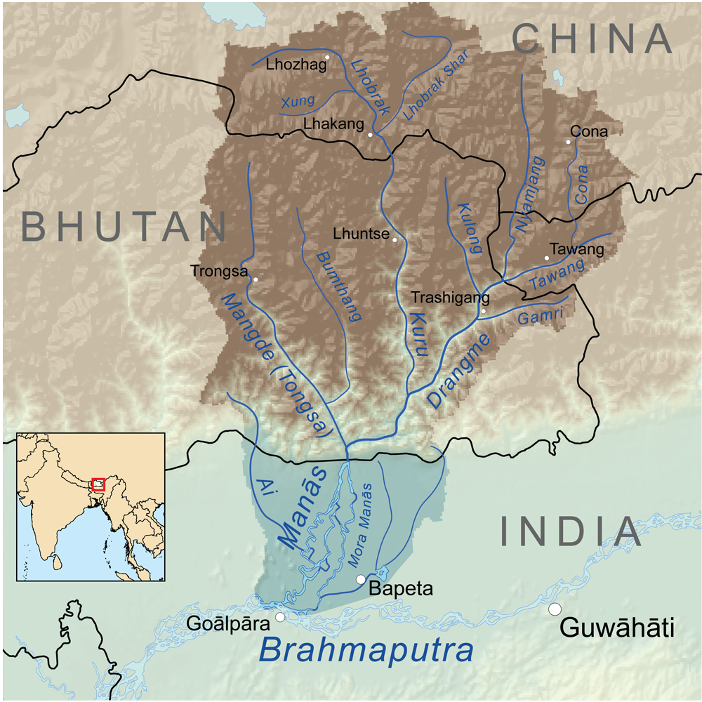
Manas River drainage basinBasin countries India, Bhutan, China Length 376 kilometres (234 mi) River system Brahmaputra River The Manas River is a transboundary river in the Himalayan foothills between southern Bhutan and India. It is named after Manasa, the serpent god in Hindu mythology.It is the largest river system of Bhutan,[1] among its four major river systems; the other three are Amo Chu or Torsa, Wong Chu or Raidak, Mo Chu or Sankosh. It is met by three other major streams before it again debouches into India in western Assam. The total length of the river is 376 kilometres (234 mi), flows through Bhutan for 272 kilometres (169 mi) and then through Assam for 104 kilometres (65 mi) before it joins the mighty Brahmaputra River at Jogighopa. Another major tributary of the Manas, the Aie river joins it in Assam at Bangpari.[2][3]
The river valley has two major reserve forest areas, namely the Royal Manas National Park (43,854 hectares (108,370 acres), established in 1966) in Bhutan and the contiguous Manas Wildlife Sanctuary (391,000 hectares (970,000 acres) in 1955 increased to 95,000 hectares (230,000 acres) in December 1985) encompassing Project Tiger Reserve, an Elephant Reserve and a Biosphere Reserve, which constitutes a UNESCO World Heritage Site declared in December 1985.[4][5]
Contents
Geography
The Manas River valley formed by the Manas river system encompasses territory in Bhutan (eastern Bhutan) and India with a total drainage area of 41,350 square kilometres (15,970 sq mi). It is called the Drangme Chhu, flows in southwesterly direction from Arunachal Pradesh in India. It has three major branches: the Drangme Chhu, Mangde Chhu, and Bumthang Chhu that cover most of eastern Bhutan, with the Tongsa and Bumthang valleys also forming part of its catchment. The area drained in Bhutan territory is 18,300 km2 and is bound by the geographical coordinates 26°13′01″N 90°37′59″E / 26.217°N 90.633°E.[6][7] A part of the main stem of the river rises in the southern Tibet before entering into India at Bumla pass at the northwestern corner of Arunachal Pradesh.[8]
The river flows through Bhutan in a south-west direction between two ranges of the Lower Himalayas in V-shaped gorges and enters into Assam in India in to the south-central foot hills of the Himalayas. The valley opens up in the foot hills; marked by the formation of swamps and marshes in the plains. The upper catchment is snow bound while the middle and lower catchment are thickly forested.[8]
 Clear waters of the Manas River in the sanctuary
The river system as a whole in Bhutan constitutes a length of 3,200 kilometres (2,000 mi), the main stem of the river is the Manas or Gongri river, which originates in the West Kameng District of Arunachal Pradesh in India and after flowing in a south westerly direction (the rivers in Bhutan generally flow from northwest to southwest) enters Bhutan near Tashigang. At Tashigong, it is joined by the Kulong Chu, which rises in the northern Himalaya snow ranges of Bhutan. At Tashigong, the bed width of the river is about 550 metres (1,800 ft) and river bed elevation is 606 metres (1,988 ft). The river Kulong Chu is formed by two rivers namely, the Tongsa (Mangde) Chu that rises in northern Bhutan near Kula Kangri Peak where the elevation is 1,666 metres (5,466 ft) and the Bumthang River, also called Murchangphy Chu; the combined stream joins the Manas river.[2]
The Lhobrak, or Kuri Chhu, is the main central tributary of the Manas. It is the only river that rises north of the Great Himalayas and it joins the Manas in southern Bhutan; further downstream of the combined stream joining at the Tongsa Chu. Here, the river bed level is 121 metres (397 ft).[2] After flowing in a generally south-westerly direction for about 29 km in Bhutan, the Aie river enters In India in to the Goalpara district of Assam at the village of Agrong. From here, it follows a meandering course for about 75 kilometres (47 mi) and outfalls into the Brahmaputra near Jogigopa. Aie River, which rises in the Black mountains at an altitude of about 4,915 metres (16,125 ft) near the village of Bangpari, is about 110 kilometres (68 mi) in length. The total length of the Manas measured along its longest tributary the Kur is 376 kilometres (234 mi), out of which about 104 kilometres (65 mi) lies in India.[3]
The river is surrounded by small meadows located among thickly deciduous forested foothills with many rivulets, streams and natural drainage channels related to the river system.[9] In the lower reaches of the river, there are many smooth sandy stretches populated with trees.[10] The river valley in the foothills is surrounded by small meadows located among thickly deciduous forested foothills with many rivulets, streams and natural drainage channels related to the river system. In the lower reaches of the river, there are many smooth sandy stretches populated with trees.[10]
The foot hills in Bhutan and India known as Terai and the Duars (A Sanskrit word meaning "passes" or "gates"), which encompass 15–30 kilometres (9.3–19 mi) stretch of the foot hills and which are very fertile. Each Duar (with elevation varying from 100 metres (330 ft) to near sea level as they join the Brahmaputra river) is named after a stream or hemmed between two streams. Some part of the Duars in Bhutan was under British control. The fertile lands have been developed into tea estates and paddy fields.[11]
Hydrology
The catchment is wholly mountainous, rising within the space of 140 kilometres (87 mi) from an elevation of about100 metres (330 ft) near the Indian border to the great Himalayan peaks at over 7,500 metres (24,600 ft) along the main Himalayan range bordering Bhutan and Tibet. The huge altitudinal range and varied climatic conditions are reflected in the great ecological diversity and rich fauna and flora in the river catchment.;[5]
Climate
The climate is extremely varied, ranging from hot and humid subtropical conditions in the south to cold and dry alpine conditions in the north. From May to October, the southwest monsoon brings heavy rainfall (over 4,000 millimetres (160 in) to the southern part, and there is a pronounced dry season in winter. Further north, the rainfall is generally scanty, of the order of 600–700 millimetres (24–28 in), recorded during June–August.[5]
The difference between maximum and minimum river flow in monsoon and the dry months is said to be as much as 20 times.[5] The Manas river, the largest north bank tributary of the Brahmaputra, has a recorded maximum discharge of 7,641 cubic metres and contributes 5.48 % of the total flows of the Brahmaputra. Its total length up to its confluence with the Brahmaputra is 375 kilometres (233 mi) (270 kilometres (170 mi) in hills and balance in plains) and raises at an altitude of4,500 metres (14,800 ft). It has a total catchment area of 41,350 square kilometres (15,970 sq mi) out of which 85.9% is in hills and plains.[5]
Reserved areas
 A suspension bridge across the Manas River in reserved area of the Park
Out of the large catchment of the river valley, protected or reserved areas have been specifically demarcated, both in Bhutan and India, which are declared national parks or sanctuaries. The two reserved forest and wild life areas cover an area of 9,938.54 square kilometres (3,837.29 sq mi), which account for about 24% of the total catchment area of 41,350 square kilometres (15,970 sq mi) of the Manas river valley; brief details are provided.
Royal Manas National Park
Main articles: Manas National Park and Royal Manas National ParkRoyal Manas National Park in southern Bhutan, considered the national heritage of Bhutan, was declared a wildlife sanctuary in 1996 and subsequently raised to the status of a national park in 1993. Covering an area of 9,938.54 square kilometres (3,837.29 sq mi), the area is forested to the extent of 92% and is well-preserved Eastern Himalayan eco system. The park is bounded on its north by the Black Mountain National Park and the Manas Tiger Reserve on its South in India. Within Bhutan, biological corridors linked with the park are the Thrumshingla National Park in the North, Phibsoo Wildlife Sanctuary in the West, and Khaling Wildlife Sanctuary in the East. As researched so far, the park has a large diversity of tropical grasslands, temperate moist forests, alpine meadows, and scrublands. The various flora and fauna identified in the park are 45 species of mammals, 366 species of birds and 900 species of vascular plants. World Wildlife Fund (WWF) is actively working on a conservation management plan in association with local wildlife authorities to preserve and protect this national heritage.[12] Some of the important faunal species identified are: the Royal Bengal Tiger, Elephant, Gaur (Bos gaurus), four rare species of Golden langur (Trachypithecus geei), Pygmy hog (Sus salvanius), Hispid hare (Caprolagus hispidus), Greater one-horned rhinoceros (Rhinoceros unicornis) and Wild Asiatic Water Buffalo (Bubalus arnee). There are 362 species of birds, out of which four species of Hornbills (namely Rufous-necked, Wreathed, Pied and Great Indian) have been recorded. Apart from the Ganges River Dolphin (Platanista gangetica) other aquan species identified in the river are the Deep bodied mahseer (Tor tor), Golden mahseer (Tor putitora), and Chocolate mahseer or Katle (Acrossocheilus hexangonolepis). Five southand people live within the park limits in several villages.[13] Tiger, which is the most revered animal in Bhutan, estimated to number about 100 are mostly conserved in this national park and also in the neighbouring Manas National Park in India[14]
The world's rarest monkeys, the Golden langur, which flourish in dense forests, “with its long tail with a tassel at the end, are found both in Bhutan and India, in the two reserved forest sanctuaries. These monkeys found in groups have no hair on their black face but have generous golden ruff on their body. They are found in large numbers – 180 in India and 1200 in Bhutan, as per counts made in 1978 and 1980 respectively.[15]
Manas Wild Life Sanctuary
Main article: Manas Wildlife Sanctuary Manas Wildlife Sanctuary in the Manas valley
The Manas Wild Life Sanctuary, located in Assam, is considered as one of “Asia's finest wild life reserves” and is a UNESCO World Heritage Site. It is contiguous to the Bhutan's Royal National Park to its north. It now encompasses a Bio Reserve, a Tiger reserve and also an Elephant Reserve. The park is well forested and also comprises grass lands and marshes. In 1928, the core of the area was designated a sanctuary and in 1978 it was declared a Tiger Reserve.[16]
Manas River and another tributary of Manas, the Hakua, flow through the sanctuary. Thick mantle of Alluvium is the dominant soil of the terrain. Under subtropical climatic conditions (with 30 millimetres (1.2 in) of annual rainfall and temperature varying from a maximum of 30 °C (86 °F) and a minimum of 5 °C (41 °F), the forest consists of the semi-evergreen forest vegetation with mixed deciduous, littorals and swamps, and interspersed with bamboo and cane. Flooding occurs in large part of the Bio Reserve.[8][17]
The Park is managed under several conservation management units such as the Core Zone, the Buffer Zone, and the Economic Zone. The park is known for its rare and endangered endemic wildlife such as the Tigers, elephants, Assam Roofed Turtle, Hispid Hare, Golden and capped Langurs and Pygmy Hog, One-horned rhinoceros, Asiatic Buffalo, swamp deer, barking deers, leopards, clouded leopards, marbled cats, sloth bears, hoolock gibbons, wild boar, gharials, crocodiles, and river dolphins. Reptiles consist of pythons, common Indian crocodile, Common wolf snake, cat snake and many other species. Birds listed include hornbills, Common Crane, Common red shank, Wood cock, Spotted eagles, Black-throated diver, Little Grebe, different types Herons, Black ibis, Sparrow hawk, Forest eagle owl and several other species of birds. The park is home for 22 endangered mammal species. Fishes species identified are: Katli, Jurraha, Chenga, Telliah, Labeo and Mahaseer.[18] Conservation measures have been undertaken to prevent poaching, over fishing, encroachments, and many other related issues. These measures are meant to minimise human interference in the fragile core zone, creation of a data base and carry out research on animal and plant populations for better conservation of the eco system.[19]
In 1980, the park has been central to the Bodoland agitation of Assam as the Bodos dominating the area took refuge in the sanctuary. Bodos have been demanding autonomy or a separate state of their own since their grouse has been that their lands were incorporated into Assam during the British Raj.[18]
River development options
One of the development projects planned in the past on the Manas River envisaged flood control in the Brahmaputra River and augmentation of flows in the Ganga river system by building a dam on the river at the Indo-Bhutan border. The stored water stored behind the reservoir was proposed to be transferred through a long canal system through the foot hills of the Himalayas(skirting Bangladesh) crossing 25 major and minor rivers, out of which the major rivers the Sankosh, Raidak, Amo (Torsa), Kartoya, Teesta, Atrai and Mahananda through North Bengal, and finally out falling into the Kosi River in North Bihar. The project has not proceeded further due to several adverse public opinion and environmental concerns.[20][21]
The proposal mooted in the 1970s to build a dam on the river for multipurpose uses of power, irrigation and flood control in Assam involved a 100 kilometres (62 mi) long canal from the Manas reservoir to another reservoir on the Sankosh River. As the canal was passing through the Manas Tiger Reserve, the Ministry of Environment and Forests of Government of India objected to the proposal on the grounds of adverse impact that would occur due to the dam on the Hydrology and ecology of the area. This view was also supported by the World Heritage Committee of UNESCO. The late Prime Minister of India, Rajeev Gandhi upheld the objections and decided to discontinue with the project. It is unlikely to be revived.[22] The proposal had been mooted as a joint project of India and Bhutan. The pre-feasibility report prepared for this Manas multipurpose project envisaged power generation of 2800 MW. Another cooperation project on the Mandgde Chu, in central Bhutan, tributary of Manas, envisages power generation of 360/600 MW for which Detailed Project Report (DPR) is under preparation.[23]
Environmental threats
The Manas River has often been the centre of environmental controversies, particularly in the 1980s. Two dams were proposed for building on the Bhutanese side of the river to provide hydroelectric power and to control the flow of the Brahmaputra on its northern bank and make way for irrigation schemes. However, there were not only local concerns but national and international ones among environmentalists in regards to the proposals who lobbied enough support to ensure that the dam proposals were dropped in 1986.[21] In February 1989, the All Bodo Students Union (ABSU) invaded the park and killed several wardens and guards, permitting the entry of poachers and loggers who posed an immediate threat to the wildlife of the park and its river. The threat flooding remained as ever in 2010[21]
References
- ^ "Physiological survey". Food and Agricultural Organization. http://www.fao.org/docrep/field/003/L8853E/L8853E02.htm. Retrieved 2010-04-02.
- ^ a b c "Physiological Survey". FAO Corporate Document Repository. http://www.fao.org/docrep/field/003/L8853E/L8853E02.htm. Retrieved 2010-03-07.
- ^ a b Report Volume I: Rashtriya Barh Ayog (National Commission On Floods). Government of India. 1973.
- ^ "Royal Manas National Park, Bhutan". WWF Global. http://www.panda.org/who_we_are/wwf_offices/bhutan/projects/index.cfm?uProjectID=BT0010.
- ^ a b c d e "Bhutan". Ramsar. Wetlands.org. http://ramsar.wetlands.org/Portals/15/Bhutan.pdf. Retrieved 2010-03-07.
- ^ "Manas river". http://www.tageo.com/index-e-bt-v-00-d-m3206481.htm?Manas+river. Retrieved 2010-03-06.
- ^ "River Systems". http://countrystudies.us/bhutan/16.htm. Retrieved 2010-03-06.
- ^ a b c Negi, Sharad Singh (1991). Himalayan rivers, lakes, and glaciers. Indus Publishing. pp. 97–99. ISBN 8185182612. http://books.google.co.in/books?id=5YtUShKY8zcC&pg=PA99&dq=Manas++River+in+Bhutan&cd=1#v=onepage&q=Manas%20%20River%20in%20Bhutan&f=false. Retrieved 2010-04-04.
- ^ "The Manas River bordering Bhutan famous for the game fish "Golden Masheer"". En.tixik. http://en.tixik.com/image-560695.htm. Retrieved 2010-03-06.
- ^ a b "What to See - Manas National Park". Nivalink. http://www.nivalink.com/bansbari/facilities.html. Retrieved 2010-03-06.
- ^ Brown, Lindsay; Bradley Mayhew, Stan Armington and Richard Whitecross (2007). Bhutan. Lonely Planet. pp. 83–86. ISBN 1740595297. http://books.google.co.in/books?id=s-L8NUlW_QgC&pg=PA84&dq=Manas++River+in+Bhutan&cd=3#v=onepage&q=Manas%20%20River%20in%20Bhutan&f=false. Retrieved 2010-04-04.
- ^ "Royal Manas National Park, Bhutan". WWF for a Living Planet. http://www.panda.org/who_we_are/wwf_offices/bhutan/projects/index.cfm?uProjectID=BT0010. Retrieved 2010-04-04.
- ^ "Parks of Bhutan". Bhutan Trust Fund for Environment Conservation. http://74.125.153.132/search?q=cache:1LcOgm7dJw0J:www.bhutantrustfund.bt/parks-of-bhutan+Manas+River+in+Bhutan&cd=32&hl=en&ct=clnk&gl=in. Retrieved 2010-04-04.
- ^ Brown p.86
- ^ Thapar, Valmiki (1997). Land of the tiger: a natural history of the Indian subcontinent. University of California Press. pp. 64–65. ISBN 0520214706. http://books.google.co.in/books?id=9Dvx6EoLwa4C&pg=PA65&dq=Manas++River+in+Bhutan&cd=9#v=onepage&q=Manas%20%20River%20in%20Bhutan&f=false. Retrieved 2010-04-04.
- ^ Kemf, Elizabeth (1993). Indigenous peoples and protected areas: the law of mother Earth. Earthscan. pp. 156–161. ISBN 1853831670. http://books.google.co.in/books?id=a7urXnqCitoC&pg=PA159&dq=Manas++River+in+Bhutan&lr=&cd=13#v=onepage&q=Manas%20%20River%20in%20Bhutan&f=false. Retrieved 2010-04-04.
- ^ Negi, Sharad Singh (1996). Biosphere reserves in India: landuse, biodiversity and conservation. Indus Publishing. pp. 86–94. ISBN 8173870438. http://books.google.co.in/books?id=ZrP3-4IFtMUC&pg=PA86&dq=Manas++River+in+India&cd=1#v=onepage&q=&f=false.
- ^ a b Kemf p.157
- ^ Negi p.93
- ^ "River-Linking and Assam's Interests". The South Asian. http://www.thesouthasian.org/archives/2003/riverlinking_and_assams_intere.html. Retrieved 2010-04-04.
- ^ a b c Reijnders, P. J. H. ; Oliver, William L. R. (1993). Seals, fur seals, sea lions, and walrus: status survey and conservation action plan. IUCN/SSC action plans for the conservation of biological diversity. The IUCN conservation library. p. 126. ISBN 2831701414. http://books.google.co.uk/books?id=8IkvLQtkpwYC&pg=PA126&dq=manas+river,+assam&cd=5#v=onepage&q=manas%20river%2C%20assam&f=false.
- ^ Kemf p.159
- ^ "Intercountry Cooperation in Development of Hydropower" (ppt). Indi-Bhutan Coopertaion Projects. National Informatics Centre. p. 11. http://www.powermin.nic.in/whats_new/pdf/India-Cooperation%20with%20neighbouring%20countries.pps#10. Retrieved 2010-04-04.
See also
Rivers of Bhutan Western Bhutan Amo Chhu or Torsa • Di Chhu or Jaldhaka • Ha Chhu • Mo Chhu/Puna Tsang Chhu or Sankosh • Paro Chhu • Tang Chuu • Wong Chhu or RaidakEastern Bhutan Bumthang or Murchangphy Chhu • Kuri Chhu or Lhobrak • Manas River/ Drangme Chhu • Mangde or Tongsa ChhuHydrology of Northeast India1 Rivers Bhogdoi • Siang/Dihang/Brahmaputra • Dhansiri • Dihing • Diphlu • Feni • Gumti • Haora • Iril • Kaladan • Kameng or Jia Bhoreli • Karnaphuli • Khowai • Kolong • Lohit • Manas/ Drangme Chhu • Manu • Mora Dhansiri • Muhuri • Mora Diphlu • Sankosh or Puna Tsang Chhu • Simsang or Someshwari • Surma • Surma-Meghna River System • Thega River • TirapLakes Waterfalls Fluvial islands 1 Assam, Arunachal Pradesh, Nagaland, Manipur, Tripura, Mizoram, Meghalaya Categories:- Rivers of Assam
- Rivers of Bhutan
- Sacred rivers
- Tributaries of the Brahmaputra River


Wikimedia Foundation. 2010.