- Copiapó Province
-
Copiapó Province
Provincia de Copiapó— Province — Location in the Atacama Region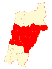 Location in Chile
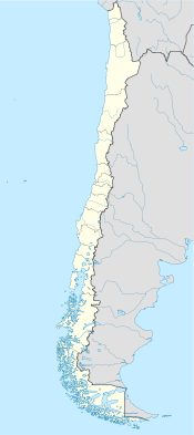
 Copiapó Province
Coordinates: 27°27′S 70°00′W / 27.45°S 70°WCoordinates: 27°27′S 70°00′W / 27.45°S 70°W Country Chile Region Atacama Capital Copiapó Communes Copiapó
Caldera
Tierra AmarillaGovernment[1] – Type Provincial – Governor Nicolás Noman Garrido Area[2] – Total 32,538.5 km2 (12,563.2 sq mi) Population (2002 Census)[2] – Total 155,713 – Density 4.8/km2 (12.4/sq mi) – Urban 148,101 – Rural 7,612 Sex[2] – Men 79,436 – Women 76,277 Time zone CLT [3] (UTC-4) – Summer (DST) CLST [4] (UTC-3) Area code(s) 56 + 52 Copiapó Province (Spanish: Provincia de Copiapó) is one of three provinces of the northern Chilean region of Atacama (III). Its capital is the city of Copiapó.
Contents
Geography and demography
According to the 2002 census by the National Statistics Institute (INE), the province spans an area of 32,538.5 km2 (12,563 sq mi)[2] and had a population of 155,713 inhabitants (79,436 men and 76,277 women), giving it a population density of 4.8 /km2 (12 /sq mi). It is the tenth largest province in the country. Between the 1992 and 2002 censuses, the population grew by 24.9% (31,021 persons).[2]
Administration
As a province, Copiapó is a second-level administrative division of Chile, which is further divided into three communes (comunas). The province is administered by a presidentially appointed governor. Nicolás Noman Garrido was appointed by president Sebastián Piñera.[1]
Communes
References
- ^ a b (Spanish) "Gobierno de Chile: Gobernadores". Government of Chile. http://www.subdere.gov.cl/1510/w3-article-67516.html. Retrieved 18 March 2011.
- ^ a b c d e (Spanish) "Territorial division of Chile" (PDF). National Statistics Institute. 2007. http://www.ine.cl/canales/chile_estadistico/territorio/division_politico_administrativa/pdf/dpa_completa.pdf. Retrieved 18 March 2011.
- ^ "Chile Time". WorldTimeZones.org. http://www.world-time-zones.org/zones/chile-time.htm. Retrieved 2010-07-28.
- ^ "Chile Summer Time". WorldTimeZones.org. http://www.world-time-zones.org/zones/chile-summer-time.htm. Retrieved 2010-07-28.
Provinces of Chile Aisén • Antártica Chilena • Antofagasta • Arauco • Arica • Biobío • Cachapoal • Capitán Prat • Cardenal Caro • Cauquenes • Cautín • Chacabuco • Chañaral • Chiloé • Choapa • Coihaique • Colchagua • Concepción • Copiapó • Cordillera • Curicó • El Loa • Elqui • General Carrera • Huasco • Iquique • Isla de Pascua • Limarí • Linares • Llanquihue • Los Andes • Magallanes • Maipo • Malleco • Marga Marga • Melipilla • Ñuble • Osorno • Palena • Parinacota • Petorca • Quillota • Ranco • San Antonio • San Felipe de Aconcagua • Santiago • Talagante • Talca • Tamarugal • Tierra del Fuego • Tocopilla • Última Esperanza • Valdivia • Valparaíso< Communes and municipalities in Atacama Region > Chañaral Province 
Copiapó Province Huasco Province Categories:


Wikimedia Foundation. 2010.