- El Monte, California
:"El Monte" redirects here; for the city in
Chile , seeEl Monte, Chile ."Infobox Settlement
official_name = City of El Monte,Los Angeles, California
settlement_type =City
nickname =
imagesize =
image_caption =
image_
mapsize = 250x200px
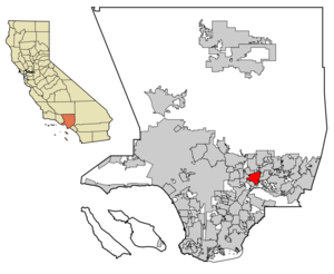
map_caption = Location of El Monte in the County of Los Angeles
mapsize1 =
map_caption1 =
subdivision_type = Country
subdivision_type1 = State
subdivision_type2 = County
subdivision_name =United States
subdivision_name1 =California
subdivision_name2 = Los Angeles
government_type =
leader_title =Mayor
leader_name = Ernest Gutierrez
area_note =
established_date =
area_magnitude =
area_total_km2 = 25.1
area_total_sq_mi = 9.7
area_land_km2 = 24.7
area_land_sq_mi = 9.6
area_water_km2 = 0.4
area_water_sq_mi = 0.1
elevation_m = 91
elevation_ft = 299
latd = 34 |latm = 4 |lats = 24 |latNS = N
longd = 118 |longm = 1 |longs = 39 |longEW = W
population_as_of = 2000
population_note =
population_total = 115965
population_density_km2 = 4688.4
timezone = PST
utc_offset = -8
timezone_DST = PDT
utc_offset_DST = −7
latitude = 0°0'0" N
longitude = 0°0'0" W
website =
postal_code_type =ZIP code s
postal_code = 91731-91735
area_code = 626
blank_name = FIPS code
blank_info = 06-22230
blank1_name = GNIS feature ID
blank1_info = 1652702
footnotes =El Monte (pron-en|ɛl ˈmɒnti) is a city in Los Angeles County,
California ,United States , and is considered a suburb ofLos Angeles . The city's slogans are "the end of the Santa Fe Trail" and "Welcome to Friendly El Monte." As of the 2000 census, the city had a total population of 115,965. As of 2002, El Monte is the 191st largest city in theUnited States . It was also the 44th largest city inCalifornia . El Monte Lies in theSan Gabriel Valley region East of the city ofLos Angeles . It is Highly mistaken asEast LA .History
Settlement began in 1849, though missionaries and Spanish soldiers passed through the area as early as the 1770s. The Old Spanish Trail, originating in Santa Fe, New Mexico passed through El Monte. During the 1930s, the city became an important site for the
New Deal 's federal Subsistence Homestead project, aResettlement Administration program that helped supply single-family ranch houses to qualifying applicants. Celebrated photographerDorothea Lange snapped several pictures of the housing units as part of her work for theFarm Security Administration .The community of El Monte was the first in California founded by American
Anglo s. Once home to many settlers from the 1930s eraDust Bowl Migration, the city became increasinglyLatino and is often viewed as a stronghold of Latinos. However, the city has experienced a rapid growth in the Asian population - particularly ethnic Chinese, Taiwanese, and Vietnamese - in recent years. Several small Vietnamese businesses have since cropped up along the stretch of Garvey Avenue.El Monte was the birthplace of John Larkin, also known as (
Scatman John ) and briefly home to authorJames Ellroy until his mother Geneva was murdered there, and to musicianJoe McDonald , who performed in the 1960s withCountry Joe & the Fish .Cheech Marin ofCheech and Chong fame was a resident, as wasFrank Zappa , who referencedEl Monte Legion Stadium in his song "Dog Breath in the Year of the Plague ." El Monte is also the home of local columnist and decathlete John Orona. Former Baseball GreatFred Lynn also lived in El Monte. A popular local attraction from 1925-1942 wasGay's Lion Farm . The famous live lion farm no longer exists, but a memorial statue can be seen next to the I-10 freeway on the SE corner of Valley Blvd. and Peck Road.Actor-filmmakerTimothy Carey filmed much of his celebrated underground feature "The World's Greatest Sinner" (1962) in El Monte. El Monte is also credited with being the birth place of TV Variety Shows. El Monte is also famous for the American Legion dance hall (the 'it' place at the time). Some Famous singers who performed there include:Ritchie Valens ,Rosie & The Originals ,Brenton Wood , andEarth Wind & Fire . The stadium is also famous for making long time Dj'sArt Laboe , andHuggy Boy very loved and famed. Unfortunately the Stadium was torn down due to the Gang brawls, and many fist fights with thePachucos , orZoot Suits .Name origin
According to the city website: "Between the 1770s and 1830s, missionaries and Spanish soldiers stopped here, and named the area, 'El Monte,' which referred not to the mountain as most assume, but to that era's definition—'meadow or marsh' or 'the wooded place.'" [http://www.ci.el-monte.ca.us/aboutem/pdf/Heritage.pdf El Monte City Website Heritage page] ]
Geography
El Monte is located at coor dms|34|4|24|N|118|1|39|W|city (34.073276, -118.027491)GR|1.
According to the
United States Census Bureau , the city has a total area of 9.7square mile s (25.1km² ), of which, 9.6 square miles (24.7 km²) of it is land and 0.1 square miles (0.4 km²) of it (1.44%) is water.Demographics
As of the
census GR|2 of 2000, there were 115,965 people, 27,034 households, and 23,005 families residing in the city. Thepopulation density was 12,139.5 people per square mile (4,688.4/km²). There were 27,758 housing units at an average density of 2,905.8/sq mi (1,122.2/km²). The racial makeup of the city was 35.67% White, 0.77% Black or African American, 1.38% Native American, 18.51% Asian, 0.12% Pacific Islander, 39.27% from other races, and 4.29% from two or more races. 72.39% of the population were Hispanic or Latino of any race.There were 27,034 households out of which 53.3% had children under the age of 18 living with them, 57.0% were married couples living together, 18.5% had a female householder with no husband present, and 14.9% were non-families. 10.9% of all households were made up of individuals and 4.9% had someone living alone who was 65 years of age or older. The average household size was 4.24 and the average family size was 4.43.
In the city the population was spread out with 34.1% under the age of 18, 12.1% from 18 to 24, 31.5% from 25 to 44, 15.4% from 45 to 64, and 6.9% who were 65 years of age or older. The median age was 27 years. For every 100 females there were 102.1 males. For every 100 females age 18 and over, there were 101.0 males.
The median
income for a household in the city was $32,439, and the median income for a family was $32,402. Males had a median income of $21,789 versus $19,818 for females. Theper capita income for the city was $10,316. About 22.5% of families and 26.1% of the population were below thepoverty line , including 33.9% of those under age 18 and 13.3% of those age 65 or over.El Monte's population has grown very rapidly during the last half century:
*1960 - 31,900
*1970 - 70,975
*1980 - 79,494
*1990 - 106,209
*2000 - 115,965
*2004 - 122,123 (estimate)Crime
The city of El Monte has a very high crime rate dealing with gangs, robberies and murders. El Monte is also home to one of the oldest gangs in the valley, The
El Monte Flores , or EMF Gang. It is also home to many other Hispanic Street Gangs such asEl Monte 13 ,El Monte Hicks , andEl Monte Hayes , all of which are no longer active. El Monte is considered to be one of the most dangerous cities in theSan Gabriel Valley , and theLos Angeles metropolitan area.Many Local parks in the El Monte community are infested with Gang Members and Drug Dealers. Some of the most dangerous are; Lambert Community Park, Zamora Park, AND Mountain View Park.
Media
El Monte is also famous for the cleverly titled oldie, "
Memories of El Monte ". The Song is in remembrance of The El Monte Legion Stadium and can be heard on many albums includingArt Laboe's Memories of El Monte chools
The
El Monte Union High School District consists of the follwing schools:
*Arroyo High School
*El Monte High School
*Mountain View High School
*South El Monte High School
*Fernando R. Ledesma High School , Formerly known as Valley Lindo Continuation
*Rosemead High School
*El Monte-Rosemead Adult School
*San Gabriel Valley Conservation Corps , also known as San Gabriel Valley CC or SGVCC
* [El Monte Union High School Community Day]Politics
In the state legislature El Monte is located in the 24th Senate District, represented by Democrat
Gloria Romero , and in the 49th Assembly District, represented by DemocratMike Eng . Federally, El Monte is located inCalifornia's 32nd congressional district , which has a Cook PVI of D +17 [cite web | title = Will Gerrymandered Districts Stem the Wave of Voter Unrest? | publisher = Campaign Legal Center Blog | url=http://www.clcblog.org/blog_item-85.html | accessdate = 2008-02-10] and is represented by DemocratHilda Solis .References

Wikimedia Foundation. 2010.