- Cumberland Bay
-
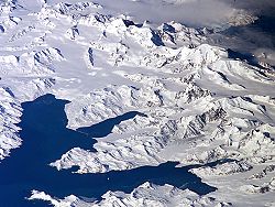 Central South Georgia: Cumberland Bay; Thatcher Peninsula with King Edward Cove (Grytviken); Allardyce Range with the summit Mt. Paget (NASA imagery).
Cumberland Bay, 6 km (3.7 mi) wide at its entrance between Larsen and Barff Points, which separates into two extensive arms that recede inland 14 km (8.7 mi) along the northern coast of South Georgia. Discovered and named in 1775 by a British expedition under James Cook.
During the Second World War the whaling stations were closed excepting Grytviken and Leith Harbour. Most of the British and Norwegian whaling factories and catchers were destroyed by German raiders, while the rest were called up to serve under Allied command. The resident British Magistrates (W. Barlas and A.I. Fleuret) attended to the island’s defence throughout the War. The Royal Navy armed the merchant vessel Queen of Bermuda to patrol South Georgian and Antarctic waters, and deployed two four-inch guns at key locations protecting the approaches to Cumberland Bay and Stromness Bay, i.e. to Grytviken and Leith Harbour respectively. These batteries (still present) were manned by volunteers from among the Norwegian whalers who were trained for the purpose.
Previous name of Guantánamo Bay
Guantánamo Bay in Cuba also bore the name "Cumberland Bay" during part of the 18th Century, when for a time it was occupied and garrisoned by the British.
Cumberland Bay in the South Pacific
There is also a Cumberland Bay on Robinson Crusoe Island.
References
- Stonehouse, B (ed.) Encyclopedia of Antarctica and the Southern Oceans (2002, ISBN 0 471 9866 58)
 This article incorporates public domain material from the United States Geological Survey document "Cumberland Bay" (content from the Geographic Names Information System).Categories:
- South Georgia and the South Sandwich Islands geography stubs
- Bays of South Georgia

Wikimedia Foundation. 2010.