- Muir Beach, California
-
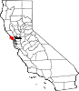
Muir Beach — census-designated place — Muir Beach is within a mile of the Green Gulch Farm property. Location in Marin County and the state of California
 Muir Beach CDP, California
Coordinates: 37°51′44″N 122°34′53″W / 37.86222°N 122.58139°WCoordinates: 37°51′44″N 122°34′53″W / 37.86222°N 122.58139°W Country  United States
State  California
County Marin Government - Type Community Services District - County Board District 4
Steve Kinsey- State Senate Mark Leno (D) - Assembly Jared Huffman (D) - U. S. Congress Lynn Woolsey (D) Area[1] - Total 0.493 sq mi (1.276 km2) - Land 0.493 sq mi (1.276 km2) - Water 0 sq mi (0 km2) 0% Elevation[2] 269 ft (82 m) Population (2010) - Total 310 - Density 628.8/sq mi (242.9/km2) Time zone PST (UTC-8) - Summer (DST) PDT (UTC-7) ZIP code 94965 Area code(s) 415 FIPS code 06-49950 GNIS feature ID 1853403 Website Muir Beach Community Services District Muir Beach is a census-designated place (CDP), unincorporated community, and beach that is located 16.5 miles (26.6 km) northwest of San Francisco in western Marin County, California, United States. The population was 310 at the 2010 census.
Located about 2 miles (3 km) from the entrance to Muir Woods National Monument, the beach is about 1000 feet (305 m) long and 200 feet (61 m) wide, with coarse sand and several large boulders. There is a parking lot at the beach, which is then accessible via a footbridge. The community itself flanks the northwest side of the beach.
Contents
Geography
Muir Beach is located at 37°51′44″N 122°34′53″W / 37.86222°N 122.58139°W.[2]
According to the United States Census Bureau, the CDP has a total area of 0.5 square miles (1.3 km²), all of it land. The beach is one of the cleanest in the state.[3]
Demographics
2010
The 2010 United States Census[4] reported that Muir Beach had a population of 310. The population density was 629.0 people per square mile (242.9/km²). The racial makeup of Muir Beach was 283 (91.3%) White, 5 (1.6%) African American, 1 (0.3%) Native American, 12 (3.9%) Asian, 1 (0.3%) from other races, and 8 (2.6%) from two or more races. Hispanic or Latino of any race were 7 persons (2.3%).
The Census reported that 95.8% of the population lived in households and 4.2% lived in non-institutionalized group quarters.
There were 141 households, out of which 27 (19.1%) had children under the age of 18 living in them, 79 (56.0%) were opposite-sex married couples living together, 4 (2.8%) had a female householder with no husband present, 3 (2.1%) had a male householder with no wife present. There were 11 (7.8%) unmarried opposite-sex partnerships, and 1 (0.7%) same-sex married couples or partnerships. 39 households (27.7%) were made up of individuals and 11 (7.8%) had someone living alone who was 65 years of age or older. The average household size was 2.11. There were 86 families (61.0% of all households); the average family size was 2.47.
The population was spread out with 38 people (12.3%) under the age of 18, 10 people (3.2%) aged 18 to 24, 56 people (18.1%) aged 25 to 44, 138 people (44.5%) aged 45 to 64, and 68 people (21.9%) who were 65 years of age or older. The median age was 52.6 years. For every 100 females there were 102.6 males. For every 100 females age 18 and over, there were 106.1 males.
There were 162 housing units at an average density of 328.7 per square mile (126.9/km²), of which 73.8% were owner-occupied and 26.2% were occupied by renters. The homeowner vacancy rate was 1.0%; the rental vacancy rate was 2.6%. 75.2% of the population lived in owner-occupied housing units and 20.6% lived in rental housing units.
2000
As of the census[5] of 2000, there were 295 people, 131 households, and 69 families residing in the CDP. The population density was 596.8 people per square mile (232.4/km²). There were 144 housing units at an average density of 291.3 per square mile (113.5/km²). The racial makeup of the CDP in 2010 was 89.7% non-Hispanic White, 0.8% non-Hispanic African American, 3.9% Asian, and 2.6% from two or more races. Hispanic or Latino of any race were 2.3% of the population.
There were 131 households out of which 19.1% had children under the age of 18 living with them, 45.0% were married couples living together, 5.3% had a female householder with no husband present, and 46.6% were non-families. 30.5% of all households were made up of individuals and 7.6% had someone living alone who was 65 years of age or older. The average household size was 2.22 and the average family size was 2.67.
In the CDP the population was spread out with 14.2% under the age of 18, 2.7% from 18 to 24, 26.1% from 25 to 44, 46.8% from 45 to 64, and 10.2% who were 65 years of age or older. The median age was 48 years. For every 100 females there were 90.3 males. For every 100 females age 18 and over, there were 91.7 males.
The median income for a household in the CDP was $125,402, and the median income for a family was $152,174. The per capita income for the CDP was $66,476. None of the families and 10.5% of the population were living below the poverty line.[6]
Education
Muir Beach is in the Mill Valley School District, Tamalpais Union High School District, and the Marin Community College District. Students attend public schools in or near Mill Valley at Tamalpais Valley Elementary School (kindergarten - grade 5), Mill Valley Middle School (grades 6 - 8), and Tamalpais High School (grades 9 - 12).[7]
Local government
Muir Beach is unincorporated, receiving general government services from Marin County, including law enforcement, land use planning, library, public health, and code enforcement. A special district, the Muir Beach Community Services District, provides local services, including fire protection, water, road maintenance, and recreation. The District has a board of directors, with five members elected to four-year terms. The District includes all of the Muir Beach CDP, plus Green Gulch Farm. (See map of MBCSD.)[8]
Notes
- ^ U.S. Census
- ^ a b U.S. Geological Survey Geographic Names Information System: Muir Beach, California
- ^ Bay Area beaches grade well for safe swimming, May 27, 2010 by Carolyn Jones, San Francisco Chronicle
- ^ All data are derived from the United States Census Bureau reports from the 2010 United States Census, and are accessible on-line here. The data on unmarried partnerships and same-sex married couples are from the Census report DEC_10_SF1_PCT15. All other housing and population data are from Census report DEC_10_DP_DPDP1. Both reports are viewable online or downloadable in a zip file containing a comma-delimited data file. The area data, from which densities are calculated, are available on-line here. Percentage totals may not add to 100% due to rounding. The Census Bureau defines families as a household containing one or more people related to the householder by birth, opposite-sex marriage, or adoption. People living in group quarters are tabulated by the Census Bureau as neither owners nor renters. For further details, see the text files accompanying the data files containing the Census reports mentioned above.
- ^ "American FactFinder". United States Census Bureau. http://factfinder.census.gov. Retrieved 2008-01-31.
- ^ U.S. Census Bureau, Muir Beach CDP, California Fact Sheet, accessed June 12, 2007
- ^ Marin County Office of Education, "Marin County Public Schools, 2006 - 2007", pages 25 - 28
- ^ Marin Local Agency Formation Commission, Directory of Marin County Local Governments, 11/17/05
See also
External links
- Muir Beach Official Site
- California Coastal Records Project, "Town of Muir Beach" (Muir Beach shoreline from the air)
- Muir Beach Community Services District
- Muir Woods National Monument
- Golden Gate National Recreation Area
- Mt. Tamalpais State Park
- Redwood Creek Watershed
West Marin Villages Bolinas • Dillon Beach • Dogtown • Inverness • Inverness Park • Lagunitas • Marshall • Millerton • Muir Beach • Nicasio • Olema • Pt. Reyes Station • Stinson Beach • TomalesGeography Audubon Canyon • Bolinas Lagoon • Bolinas Ridge • Bonita Channel • Centissima Reef • Copper Mine Gulch • Drakes Bay • Drakes Estero • Gull Rock • Pirates Cove • Point Reyes • Kent Island • Nicasio Creek • Nicasio Reservoir • Olema Valley • Rancho Punta de los Reyes Sobrante • Rodeo Lagoon • Rodeo Cove • Tennessee Cove • Tomales Bay • Sears RockParks and transportation Municipalities and communities of Marin County, California County seat: San Rafael Cities and towns Belvedere | Corte Madera | Fairfax | Larkspur | Mill Valley | Novato | Ross | San Anselmo | San Rafael | Sausalito | Tiburon
CDPs Alto | Black Point-Green Point | Bolinas | Dillon Beach | Inverness | Kentfield | Lagunitas-Forest Knolls | Lucas Valley-Marinwood | Marin City | Muir Beach | Nicasio | Point Reyes Station | San Geronimo | Santa Venetia | Sleepy Hollow | Stinson Beach | Strawberry | Tamalpais-Homestead Valley | Tomales | Woodacre
Unincorporated
communitiesAlmonte | Bel Marin Keys | Belvedere Island | Bivalve | Black Point | Blakes Landing | Burdell | California Park | Cerro | Chapman | Cypress Grove | Dewitt | Dogtown | El Campo | Fallon | Five Brooks | Forest Knolls | Gallinas | Greenbrae | Hamlet | Harbor Point | Homestead Valley | Ignacio | Inverness Park | Jewell | Kent Woodlands | Lagunitas | Lairds Landing | Las Gallinas | Los Ranchitos | Lucas Valley | Manzanita | Marconi | Marinwood | Marshall | McDonald | McNears Beach | Meadowsweet | Millerton | Murray Park | Nicks Cove | Ocean Roar | Old Town | Olema | Paradise Cay | Reed | Reynolds | Sacramento Landing | Saint Vincent | San Antonio | San Quentin | Seahaven | Shafter | Strawberry Manor | Tamalpais Valley | Tamalpais Valley Junction | Tocaloma | Vincent Landing | Waldo
Ghost towns Categories:- West Marin
- Populated coastal places in California
- Census-designated places in Marin County, California
- San Francisco Bay Area beaches


Wikimedia Foundation. 2010.