- San Rafael, California
Infobox Settlement
official_name = San Rafael, California
other_name =
native_name =
nickname =
settlement_type =City
motto =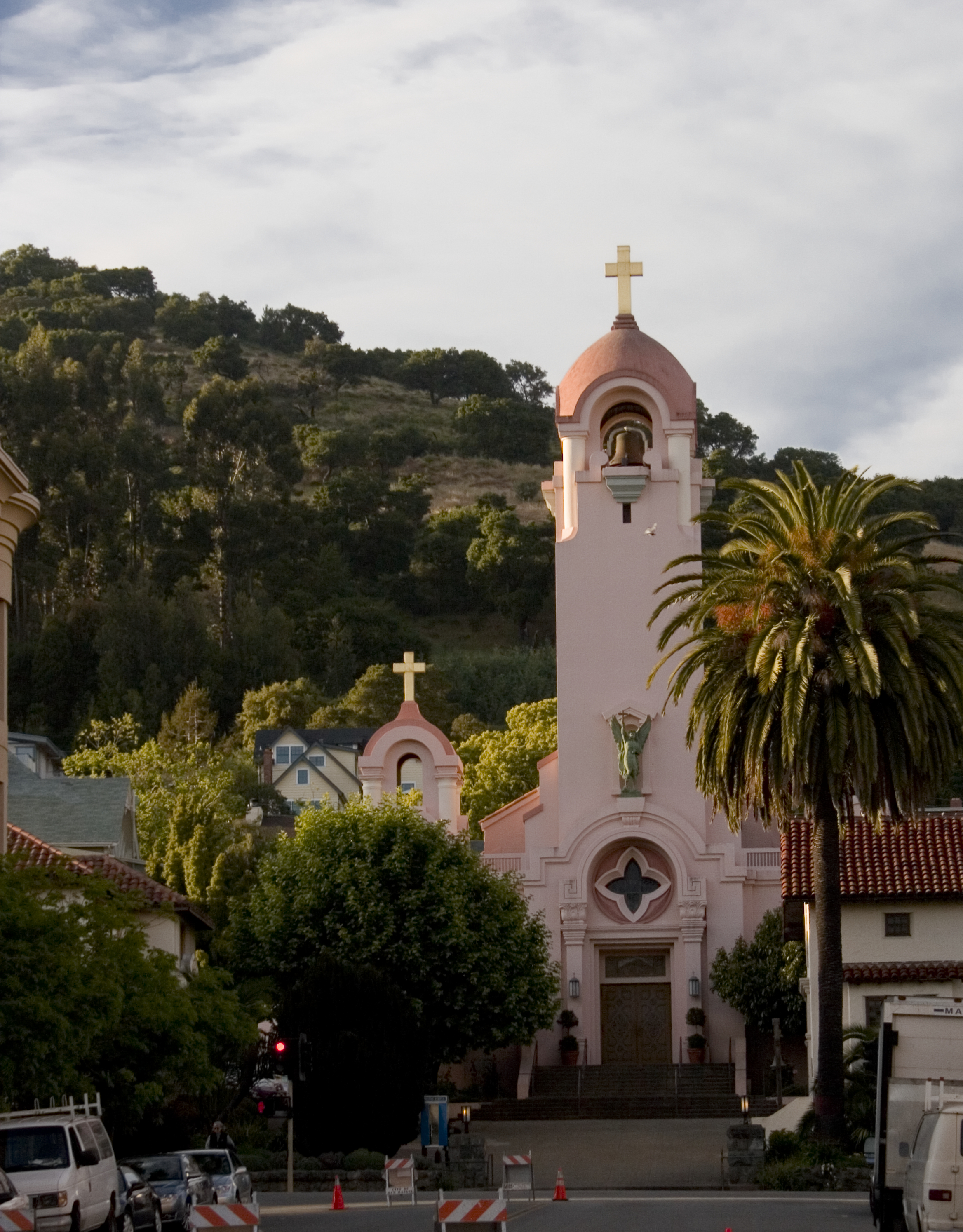
imagesize =
image_caption = Saint Raphael Church, one of the city's most recognizable landmarks
flag_size =
image_
seal_size =
image_shield =
shield_size =
image_blank_emblem =
blank_emblem_size =
flag_size =
image_
seal_size =
image_shield =
shield_size =
image_blank_emblem =
blank_emblem_size =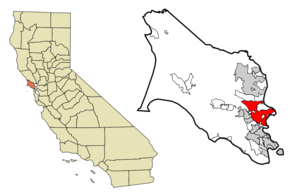
mapsize = 250x200px
map_caption = Location of San Rafael, California
mapsize1 =
map_caption1 =
image_dot_
dot_mapsize =
dot_map_caption =
dot_x =
dot_y =
pushpin_
pushpin_label_position =
pushpin_map_caption =
pushpin_mapsize =
subdivision_type = Country
subdivision_name =United States
subdivision_type1 = State
subdivision_name1 =California
subdivision_type2 = County
subdivision_name2 = Marin
subdivision_type3 = County seat of
subdivision_name3 = Marin County
subdivision_type4 =
subdivision_name4 =
government_footnotes =
government_type =Council-manager with directly electedmayor
leader_title = Mayor
leader_name = Albert J. Boro (1987–present)
(Term expires November 2007)
leader_title1 = City Manager
leader_name1 = Ken Nordhoff
leader_title2 = City Clerk
leader_name2 = Esther Beirne (2007–present)
(Term expires November 2011)
leader_title = County Board
leader_name = District 1Susan Adams
leader_title3 = Leg.
leader_name3 = Sen.Carole Migden (D)
Asm.Jared Huffman (D)
leader_title4 = U. S. Congress
leader_name4 =Lynn Woolsey (D)
established_title =
established_date =
established_title2 =
established_date2 =
established_title3 =
established_date3 =
area_magnitude =
unit_pref =
area_footnotes =
area_total_km2 = 58.1
area_land_km2 = 43.0
area_water_km2 = 15.1
area_total_sq_mi = 22.4
area_land_sq_mi = 16.6
area_water_sq_mi = 5.8
area_water_percent =
area_urban_km2 =
area_urban_sq_mi =
area_metro_km2 =
area_metro_sq_mi =
population_as_of =
population_footnotes =
population_note =
population_total = 56063
population_density_km2 = 1304.6
population_density_sq_mi = 3378.9
population_metro =
population_density_metro_km2 =
population_density_metro_sq_mi =
population_urban =
population_density_urban_km2 =
population_density_urban_sq_mi =
population_blank1_title =
population_blank1 =
population_density_blank1_km2 =
population_density_blank1_sq_mi =
timezone = PST
utc_offset = -8
timezone_DST = PDT
utc_offset_DST = -7
latd = 37 |latm = 59 |lats = 0 |latNS = N
longd = 122 |longm = 31 |longs = 25 |longEW = W
elevation_footnotes =
elevation_m = 13
elevation_ft = 43
postal_code_type =
postal_code =
area_code = 415
blank_name = FIPS code
blank_info = 06-68364
blank1_name = GNIS feature ID
blank1_info = 1659589
website =
footnotes = San Rafael (IPAEng|ˌsænrəˈfɛl; originally IPA2|sɑn rɑfɑˈɛl), is thecounty seat ofMarin County, California ,United States . The city is located in the North Bay region of theSan Francisco Bay Area . In 2002, the U.S. Census Bureau estimated that the city's population was 55,550.History
What is now San Rafael was once the site of several
Coast Miwok villages; Awani-wi, near downtown San Rafael, Ewu, near Terra Linda, and Shotomko-cha, in Marinwood. [Peterson, Bonnie J. (1976). "Dawn of the World: Coast Miwok Myths". ISBN 0-912908-04-1]Mission San Rafael Arcángel was founded in what is now downtown San Rafael as the 20th Spanish mission in the colonialMexican province of "Alta California " by four priests--FatherNarciso Durán fromMission San José , Father Abella fromMission San Francisco de Asís , FatherLuis Gíl y Taboada fromLa Iglesia de Nuestra Señora Reina de los Angeles and FatherJunípero Serra , Father Presidente of the Missions--on Dec. 14, 1817, four years beforeMexico gained independence fromSpain .The mission and city are named for the
Archangel Raphael, the Angel of Healing. The mission was originally planned as a hospital site for Central Valley American Indians who had become ill at the coldSan Francisco Mission Dolores . Father Luis Gil, who spoke several native American languages, was put in charge of the facility. In part because of its ideal weather, San Rafael was later upgraded to full mission status in 1822. The mission had 300 converts within its first year, and 1,140 converts by 1828. TheMexican government took over the California missions in 1834, andMission San Rafael was abandoned in 1844, eventually falling into ruin. The current mission was built in the style of the original in 1949, but faces at right angles to the alignment of the original.Geography
San Rafael is located at coor dms|37|58|60|N|122|31|25|W|city (37.983256, -122.523694).GR|1 According to the
United States Census Bureau , the city has a total area of 58.1 km² (22.4 mi²). 43.0 km² (16.6 mi²) of it is land and 15.1 km² (5.8 mi²) of it (26.04%) is water.Notable landmarks include: the
Mission San Rafael Arcángel , around which the city developed; theMarin County Civic Center building, designed byFrank Lloyd Wright ; theRafael Film Center ;China Camp State Park ; and the George Lucas'sSkywalker Ranch . San Rafael is served by the privately operated San Rafael Airport.Environmental features
The San Rafael shoreline has been historically filled to a considerable extent to accommodate land development, with underlying bay mud (saturated clayed silt) of up to convert|90|ft|m|0 in thickness. At certain locations such as Murphys Point, the sandstone or shale rock outcrops through the mud.
San Rafael has a wide diversity of natural habitats from forests at the higher elevations to marshland and estuarine settings. Its marshes are home to the
endangered species Salt Marsh Harvest Mouse . There are alsoriparian areas including theSan Rafael Creek andMiller Creek corridors.Climate
San Rafael has a Mediterranean climate, with mild winter lows seldom reaching the freezing mark. Average highs are in the mid 50s F° (11-15 C°) and lows are in mid 40s F°(5-10 C°). In the summer highs are around the low 80s F°. Summer lows are around the mid 50s F°(13 C°). The National Weather Service reports that August is usually the warmest month with a high of 81.3° and a low of 54.8°. This makes it possible to live in this area without air conditioning. January, the coldest month, has an average high of 56.2° and an average low of 41.3°. The highest temperature on record is 110°, recorded in June 1961. The highest temperature in recent years, 108°, occurred on July 23, 2006. [http://www.wrh.noaa.gov/mtr/heat.php] The record lowest temperature was 20° on December 22, 1990. There are an average of 19.5 days annually with a high of 90° or more and 2.1 days with a high of 100° or more. Freezing temperatures (32° or below) occur on an average of 4.2 days.
Total annual precipitation averages convert|34.29|in|mm. There are normally 68.5 days with measurable rain. The rainy season is from November to early April. Rain is rare outside of this period and it is normal to receive no rain in June, July, August, and September. The most rain in one month was convert|24.11|in|mm in January 1995. The heaviest 24-hour rainfall was convert|8.74|in|mm on December 11, 1995. A trace of snow was recorded on January 30th, 1976.
Demographics
As of the
census GR|2 of 2000, there were 56,063 people, 22,371 households, and 12,773 families residing in the city. Thepopulation density was 1,304.8/km² (3,378.9/mi²). There were 22,948 housing units at an average density of 534.1/km² (1,383.1/mi²). The racial makeup of the city was 75.8% White, 2.24% African American, 0.56% Native American, 5.59% Asian, 0.17% Pacific Islander, 11.16% from other races, and 4.53% from two or more races. 23.3% of the population were Hispanic or Latino.There were 22,371 households out of which 25.8% had children under the age of 18, 44.3% were married couples living together, 9.0% had a female householder with no husband present, and 42.9% were non-families. 32.1% of all households were made up of individuals and 10.9% have someone living alone who is 65 or older. The average household size was 2.42 and the average family size was 2.99. The age distribution is as follows: 19.5% under the age of 18, 8.1% from 18 to 24, 33.3% from 25 to 44, 24.8% from 45 to 64, and 14.4% who were 65 years of age or older. The median age was 38 years. For every 100 females there were 98.2 males. For every 100 females age 18 and over, there were 95.7 males.
The reported median
income for a household in the city was $60,994; the median reported income for a family was $74,398. Males reported a median income of $50,650 versus $39,912 for females. The reportedper capita income for the city was $35,762. About 5.6% of families and 10.2% of the population reported incomes below thepoverty line , including 11.7% of those under age 18 and 5.0% of those age 65 or over.Entertainment Industry
After the arrival of
George Lucas in San Rafael in 1970 to film the movieTHX 1138 , the city became a center for the entertainment industry, particularly the high-tech elements of the business.Lucasfilm was founded byGeorge Lucas in 1971, and is best known for the global hit movie series "Star Wars " and also for "Indiana Jones ". Some of the company's operations were moved to San Francisco in 2005. Portions of the Universal movie production "American Graffiti " were filmed in downtown San Rafael under George Lucas's direction, and portions of "THX 1138 " were shot at theMarin County Civic Center in San Rafael. Much of the movieGattaca , starringEthan Hawke , was also shot in the Marin County Civic Center. Industrial Light & Magic was founded in 1975 by Lucas to dospecial effect s for his films and those of other filmmakers. Thenew age music program "Hearts of Space " is headquartered here.Largely because of the presence of LucasFilm, San Rafael started to attract
video game developers, with several major studios located in the city. However, because of poor city leadership and ineffective zoning laws in the Canal neighborhood, most of the companies, including Lucas Arts, have left San Rafael:* Brøderbund Software — Founded by
Doug Carlston andGary Carlston in 1980, the company was sold toMindscape in 1998 and moved to Novato. Best known for the hit titles "Choplifter ", "Lode Runner ", "The Print Shop ", "Where in the World is Carmen Sandiego?" and "Myst ", and for being the early distributor of "SimCity ". After several subsequent acquisitions by various companies, in 2001 the remaining Brøderbund offices were moved to San Francisco.*
LucasArts — Founded byGeorge Lucas in (1984) as "LucasFilm Games"; relocated to San Francisco in 2005. Best known for "Star Wars " and "Indiana Jones " games and innovative titles such as "Grim Fandango " and "Full Throttle".*
Stormfront Studios — Founded by San Rafael nativeDon Daglow in 1988. Best known for "", manyEA Sports titles including "NASCAR Racing", "Gold Box " RPG games and the first graphicalMMORPG , "Neverwinter Nights".*
Visual Concepts — Founded byGreg Thomas in 1988, the company was bought bySega in 1999, then sold toTake Two Interactive in 2004. Best known for creating manyEA Sports titles, and recently forSega Sports and its "2K" line of sports games.*
Totally Games — Founded by former LucasArts programmer Larry Holland in 1994. Best known for a series of "Star Wars" flight sim games.*
Factor 5 — Founded inGermany in 1987 byJulian Eggebrecht , moved to San Rafael in 1996 to be close to publisher LucasArts. Best known for "Star Wars" and "Indiana Jones" games, the company now is working withNintendo .*
Telltale Games — Founded in 2004 by formerLucasArts employees. Best known for its video game adaptation of theBone (comics) book series and itsepisodic release ofSam and Max adventure games.*
Mind Control Software — Founded in 1994 byAndrew Leker , Best know forIndependent Games Festival winning game,Oasis .Parks
San Rafael contains a number of well conceived parks:
* There are two regional parks that serve statewide users:
China Camp State Park andMcNears Beach State Park .* Community parks are Albert Park, Boyd Park, Pickleweed Park and the Terra Linda Recreational Center.
* There are a number of neighborhood parks and mini-parks such as Boyd Park, Sun Valley Park, Oleander Park, Victor Jones Park, Peacock Gap Park and Gerstle Park. Gerstle Park is also a historic and walkable neighborhood south of First Street in close proximity to central Downtown.
Educational institutions
San Rafael has one university, Dominican University.
Most public schools in San Rafael are operated by the
San Rafael City Schools district.Dixie School District operates some public elementary and middle schools in San Rafael. All comprehensive public high schools are governed by San Rafael City Schools.The district operates two comprehensive public high schools:
San Rafael High School andTerra Linda High School .Public schools not operated by the district include:
* Phoenix Academy is a CaliforniaCharter school where chemically dependent students can develop a drug- and alcohol-free lifestyle, make academic progress, address emotional issues, and make sound career and vocational decisions. The school provides a highly structured and supervised program.Private schools:
*Marin Academy is a private high school in San Rafael.
* [http://www.saintraphael.com Saint Raphael School] is a K-8 school with a history linked to the Mission San Raphael.
* [http://www.saintmarksschool.org Saint Mark's School] , is a K-8 non-sectarian school located in Terra Linda.Trivia
The term "420" when used in reference to Cannabis consumption is believed to have originated in San Rafael, specifically, at San Rafael High School. Since then, use of "420" has spread throughout the rest of the United States, and much of the rest of the world, in reference to cannabis consumption on April 20. [http://www.snopes.com/language/stories/420.htm]
Notable residents
* Author
Isabel Allende [Correas Zapata, Celia (1998). "Isabel Allende: Vida y espíritus", p. 223. ISBN 0-533-061004-3]
* CyclistSusan DeMattei Fact|date=March 2008
* NovelistPhilip K. Dick Fact|date=March 2008
* MusicianGeorge Duke Fact|date=March 2008
* Professional tennis coachBrad Gilbert Fact|date=March 2008
*Lauren Grandcolas , a 9/11 victim who was onUnited Flight 93 Fact|date=March 2008
* NovelistJess Hartley born in San Rafael in 1967Fact|date=March 2008
* MusicianAli Akbar Khan Fact|date=March 2008
* Baseball Player Bill LeeFact|date=March 2008
* Director/FilmmakerGeorge Lucas Fact|date=March 2008
* Musician, artist and directorCory McAbee Fact|date=March 2008
*Supercentenarian Christian Mortensen , 1882-1998, the oldest living human male, aged 115 years and 252 days at deathFact|date=March 2008
* MusicianJerry Garcia (deceased)
* MusicianNarada Michael Walden Fact|date=March 2008
* MusicianCarlos Santana Fact|date=March 2008
* Legendary country singer/Television Pioneer Chester Smith ((Fact [ date March 2008))
* AuthorMartin Cruz Smith Fact|date=March 2008
* Movie ProducerSaul Zaentz Fact|date=March 2008
* MusicianJames Hetfield ofMetallica .Fact|date=March 2008Neighborhoods
Although not every location in San Rafael is part of a neighborhood that has a widely accepted and widely recognized name, there are some neighborhoods that have names that are accepted and recognized by most locals. The City of San Rafael [http://www.cityofsanrafael.org/Assets/CDD/4.+Neighborhoods+Element.pdf.pdf 2020 General Plan] recognizes 30 distinct neighborhoods in San Rafael:
References
Bibliography
* "San Rafael Recreation Element of the General Plan", June, 1984
*
U.S. Geological Survey , "Topographical Map,San Quentin 7.5 Minute Quadrangle", revised 1980External links
* [http://www.cityofsanrafael.org Official website of the City of San Rafael]
* [http://www.sanrafaelchamber.com San Rafael Chamber of Commerce]
* [http://www.srpubliclibrary.org San Rafael Public Library]
* [http://www.co.marin.ca.us/depts/lb/main/civic/index.cfm Civic Center Library]
* [http://www.terralinda.srcs.org Terra Linda High webpage]
* [http://www.sfgate.com/cgi-bin/article.cgi?f=/c/a/2004/10/01/NBGMN904TE1.DTL San Francisco Chronicle article about Terra Linda High Trojans]
* [http://web.srcs.org/schoolcity/ssb/content.cfm?ptc=/0x5D3F70551A96AF46/0x6CC1CAD9BEDFC84A San Rafael High School webpage]
* [http://www.snopes.com/language/stories/420.htm Snopes story of 4:20 origin at San Rafael High]
* [http://madrone.srcs.org/ Madrone High School webpage]
* [http://www.ma.org/home/ Marin Academy Website]
* [http://mcoeweb.marin.k12.ca.us/ae/phoenixacad.htm Phoenix Academy website]
* [http://www.myspace.com/104146914 San Rafael High School Unofficial Myspace.com Page]
* [http://cafilm.org Christopher B. Smith Rafael Film Center]
*Marin Local Music [http://marinlocalmusic.com] , Music listings for Marin's restaurants & venues which host live music.
Wikimedia Foundation. 2010.