- La Habra, California
Infobox Settlement
official_name = City of La Habra, California
settlement_type =City
imagesize =
image_caption =
image_
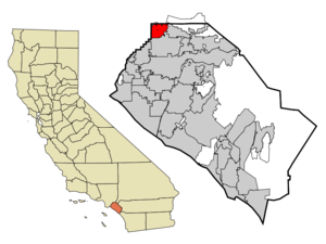
mapsize = 250x200px
map_caption = Location of La Habra withinOrange County, California .
mapsize1 =
map_caption1 =
subdivision_type = Country
subdivision_type1 = State
subdivision_type2 = County
subdivision_name =United States
subdivision_name1 =California
subdivision_name2 = Orange
government_type =
leader_title =Mayor
leader_name = Rose Espinoza
established_date =
area_magnitude = 1 E8
area_total_km2 = 19.0
area_land_km2 = 19.0
area_water_km2 = 0.0
population_as_of = 2000
population_total = 58974
population_footnotes =
population_density_km2 = 3106.4
timezone = PST
utc_offset = -8
timezone_DST = PDT
utc_offset_DST = -7
area_total_sq_mi = 7.3
area_land_sq_mi = 7.3
area_water_sq_mi = 0.0
elevation_m = 91
elevation_ft = 299
latd = 33 |latm = 55 |lats = 55 |latNS = N
longd = 117 |longm = 56 |longs = 46 |longEW = W
website = http://www.ci.la-habra.ca.us/
postal_code_type =ZIP code s
postal_code = 90631-90633
area_code = 562, 714
blank_name = FIPS code
blank_info = 06-39290
blank1_name = GNIS feature ID
blank1_info = 1652735
footnotes =La Habra is a city located in the northwestern corner of
Orange County, California ,United States . As of the 2000 census, the city had a total population of 58,974. Its related city,La Habra Heights is located to the north of La Habra, and is inLos Angeles County .Origin of Name
In the ranchos days when vast herds of Mexican cattle and horses grazed over the hills and valleys of Southern California, Don Mariano Reyes Roldan was granted convert|6698|acre|km2|0 and named his land Rancho Cañada de La Habra. The year was 1839, and the name referred to the “Pass Through the Hills,” the natural pass to the north first discovered by Spanish explorers in 1769. In the 1860s Abel Stearns purchased Rancho de La Habra. Soon thereafter, heavy flooding followed by a severe drought brought bankruptcy to many cattle ranchers.
History
The first La Habra Post Office was established in 1898 in a corner of Coy's Store at Central (now La Habra Boulevard) and Euclid Street.
The City was incorporated under general law on January 20, 1925 with a population of 3,000. The Police Force was organized in 1926 and employed a Chief, Traffic Officer and Patrolman. By 1928, the City bore the distinction of being the largest avocado center in Southern California. In 1930 the first Fire Department building was constructed followed by the original City Hall in 1935. By 1950 the population reached nearly 5,000. The Civic Center took shape when the existing County Library was dedicated in 1966, followed by the present Administration Building in 1969.
Richard Milhous Nixon opened his first law office in La Habra just west of the Civic Center on the north side of La Habra Boulevard. That brick building was demolished in the 1990s for the construction of the City's Community Center.For over seventy years La Habra was home to the [http://www.avocado.org/avocado-facts/mother-tree.php Hass Avocado Mother Tree] , an accidental seedling planted by Rudolph Hass in the 1920s. The fruit from this tree has since become one of the most popular avocado cultivars worldwide. The Hass Mother Tree succumbed to root rot in 2002.
Geography
La Habra is located at coor dms|33|55|55|N|117|56|46|W (33.931944, -117.946111).GR|1
According to the
United States Census Bureau , the city has a total area of 19.0 km² (7.3 mi²), all land.Demographics
As of the
census GR|2 of 2000, there were 58,974 people, 18,947 households, and 14,020 families residing in the city. Thepopulation density was 3,106.4/km² (8,045.8/mi²). There were 19,441 housing units at an average density of 1,024.0/km² (2,652.3/mi²). The racial makeup of the city was 63.00% White, 1.57% Black or African American, 0.96% Native American, 5.93% Asian, 0.22% Pacific Islander, 23.66% from other races, and 4.67% from two or more races. 49.04% of the population were Hispanic or Latino of any race.There were 18,947 households out of which 39.3% had children under the age of 18 living with them, 54.5% were married couples living together, 13.5% had a female householder with no husband present, and 26.0% were non-families. 21.0% of all households were made up of individuals and 8.0% had someone living alone who was 65 years of age or older. The average household size was 3.08 and the average family size was 3.56.
In the city the population was spread out with 29.1% under the age of 18, 10.3% from 18 to 24, 31.7% from 25 to 44, 18.2% from 45 to 64, and 10.8% who were 65 years of age or older. The median age was 32 years. For every 100 females there were 97.1 males. For every 100 females age 18 and over, there were 94.7 males.
The median income for a household in the city was $47,652, and the median income for a family was $51,971. Males had a median income of $36,813 versus $30,466 for females. The
per capita income for the city was $18,923. About 9.1% of families and 12.9% of the population were below thepoverty line .Politics
In the state legislature La Habra is located in the 29th Senate District, represented by Republican
Bob Margett , and in the 60th and 72nd Assembly District, represented by RepublicansBob Huff andMichael D. Duvall . Federally, La Habra is located inCalifornia's 42nd congressional district , which has a Cook PVI of R +10 [cite web | title = Will Gerrymandered Districts Stem the Wave of Voter Unrest? | publisher = Campaign Legal Center Blog | url=http://www.clcblog.org/blog_item-85.html | accessdate = 2008-02-10] and is represented by RepublicanGary Miller .Notable residents
*
Jeanette Dimech - Spanish singer
*Natalie Golda - Water polo player, Olympian
*Jennifer Hanson - Country music singer
*Jenna Haze - Adult film actress
*Ann Meyers - Basketball player, Olympian. First player to be part of the U.S. National team while still in high school.
*Alan Newman - Major League Baseball Player
*Jose Luis Razo, Jr. - Noted criminal, Dubbed the "Harvard Homeboy"
*Boyd Coddington - Famous Hot Rod builder
*Zebrahead - Rap-punk Band
*The Funeral Pyre - Blackened death metal bandExternal links
* [http://www.ci.la-habra.ca.us/ City of La Habra]

Wikimedia Foundation. 2010.