- Zapata Swamp
-
Ciénaga de Zapata IUCN Category II (National Park)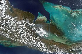
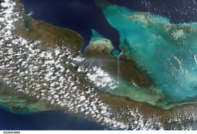
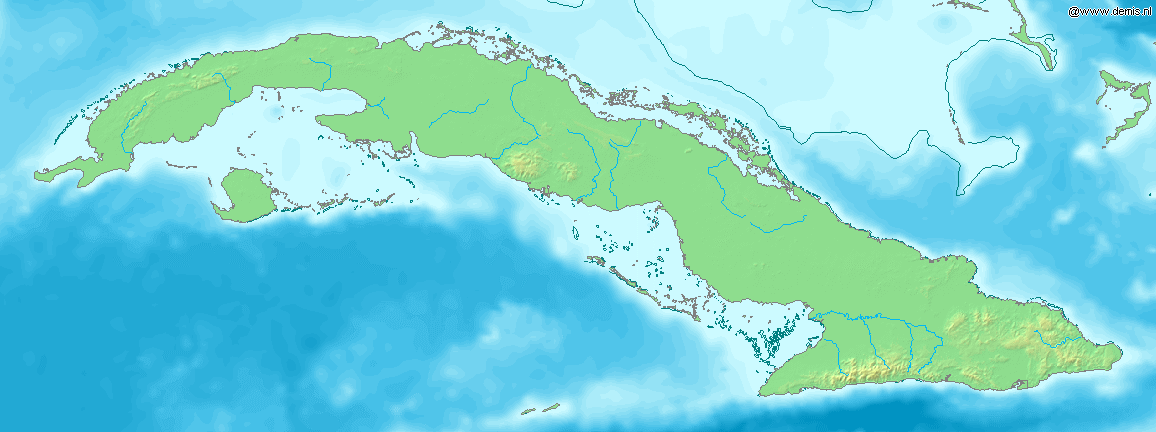
Zapata Swamp as seen from space.Location of Ciénaga de Zapata in Cuba

Location  Cuba
CubaNearest city Playa Larga
Jagüey GrandeCoordinates 22°24′26″N 81°41′26″W / 22.40722°N 81.69056°WCoordinates: 22°24′26″N 81°41′26″W / 22.40722°N 81.69056°W Area 4,354.3 km2 (1,681.2 sq mi)[1] Zapata Swamp (Spanish: Ciénaga de Zapata) is located on the Zapata Peninsula in the southern Matanzas province of Cuba. It is located less than 150 kilometres (93 mi) southeast of Havana.[2][3][4][5][6][7][8][9][10]
Contents
Species and preservation
Within the Zapata Swamp are over 900 autochthonous plant species, 175 species of birds, 31 species of reptiles and over 1000 species of invertebrates. Some of the most notable are local endemics to Cuba, for birds it would include the Zapata Wren, Zapata Rail, and the Zapata Sparrow.[5] The Zapata Swamp is also visited by 65 species of birds during their migration pattern from North America through the Caribbean to South America. Zapata is also known for the local endemic Cuban Crocodile (Crocodylus rhombifer) which are restricted to the Zapata Swamp and are being reintroduced to the nearby Lanier Swamp on the Isle of Youth (Spanish: Isla de la Juventud).[2][4][11]
Within the Zapata Swamp are numerous areas designated for environmental preservation, such as Zapata Swamp Natural Reserve and Las Salinas wildlife sanctuary, which is part of the larger Zapata Biosphere Reserve (IUCN category VI) which in total is over 6,000 km² and the largest protected area, not only in Cuba, but also the Caribbean.[7][8][9] The swamp is not only known for its size but also for being the best preserved wetlands in all of the Antilles, designated as a "Wetland of International Importance" by the Ramsar Convention on Wetlands in 1971.[8] In mid-2001 an additional 4,520 km² were declared a Ramsar Site in mid-2001.[10]
Geography
The Zapata Swamp lies between 22°01’ and 22°40’ N latitude and between 80°33’ and 82°09’ W longitude. The swamp in total is over one million acres (4,000 km²).[3] Topographically, the maximum height above sea level is only about 10 meters with the top depth in below-sea-level coastal zones as follows: 2 meters in the salt-marsh area and from 1–600 meters in the sea coastal zone. Between May and October, the warmest season of the year, average temperature is 30 °C (86 °F). Between November to April, the coldest season of the year, the temperature on average is 20 °C (68 °F).[9][10][11]
Ciénaga de Zapata is administered as one of 14 municipalities of the Matanzas Province and the municipal seat is located at Playa Larga, at the northern end of the Bahia de Cochinos. In 2004, the municipality of Cienaga de Zapata had a population of 8,750.[12] With a total area of 4,320 km2 (1,670 sq mi),[13] it has a population density of 2.0 /km2 (5.2 /sq mi).
See also
References
- ^ National Protected Areas System of Cuba. "Protected Areas". Archived from the original on 2007-08-10. http://web.archive.org/web/20070810220929/http://www.snap.cu/listados.htm. Retrieved 2007-10-10.
- ^ a b Friends of the National Zoo. "Cuban Crocodile". Smithsonian National Zoological Park. http://nationalzoo.si.edu/Animals/Amazonia/Facts/fact-cubancrocodile.cfm.
- ^ a b Jordan Levinson. "WTA Partners Pioneer Efforts In Cuban Wetland Conservation". Wildlife Trust. http://www.wildlifetrust.org/enter.cgi?p=news/2007/0701_2_cuba.shtml.
- ^ a b Brian Simpson. "Ecotourism in Cuba". Smithsonian National Zoological Park. http://nationalzoo.si.edu/Publications/ZooGoer/1999/1/ecotourismincuba.cfm.
- ^ a b "Cuba: Wild Island of the Caribbean". PBS. http://www.pbs.org/wnet/nature/cuba/eco_explorer2.html.
- ^ World Wildlife Fund. "Cuban wetlands (NT0902)". National Geographic. http://www.worldwildlife.org/wildworld/profiles/terrestrial/nt/nt0902_full.html.
- ^ a b Steve Winter. "Cuba's Wild Side". http://magma.nationalgeographic.com/ngm/0311/feature4/index.html?fs=www7.nationalgeographic.com.
- ^ a b c Stefan Lovgren (August 4, 2006). "Castro the Conservationist? By Default or Design, Cuba Largely Pristine". National Geographic News.
- ^ a b c United Nations Environment Programme - World Conservation Monitoring Centre. "World Database on Protected Areas". http://sea.unep-wcmc.org/wdbpa/sitedetails.cfm?siteid=198339&level=int&layer=pa.
- ^ a b c United Nations Environment Programme - World Conservation Monitoring Centre. "World Database on Protected Areas: Ramsar". http://sea.unep-wcmc.org/wdbpa/sitedetails.cfm?siteid=900569&level=int&layer=pa.
- ^ a b "Cuba: Ciénaga de Zapata National Park". UNESCO. February 28, 2003. http://whc.unesco.org/pg.cfm?cid=326&l=en&&state=cu&action=brief&order=region.
- ^ Atenas.cu (2004). "2004 Population trends, by Province and Municipality". Archived from the original on 2007-09-27. http://web.archive.org/web/20070927111826/http://www.atenas.inf.cu/todo/Estadisticas/TABLA+No_3balance.htm. Retrieved 2007-10-17. (Spanish)
- ^ Statoids (July 2003). "Municipios of Cuba". http://www.statoids.com/ycu.html. Retrieved 2007-10-17.
External links
- fotopedia.com, Selected photos of Zapata Swamp
Protected areas of Cuba National parks Alejandro de Humboldt · Caguanes · Ciénaga de Zapata · Desembarco del Granma · Guanahacabibes · Jardines de la Reina · Sierra Cristal · Turquino · Viñales
World Heritage Sites Alejandro de Humboldt · Camagüey · Cienfuegos · Desembarco del Granma · Old Havana · San Pedro de la Roca · South-East Coffee Plantations · Trinidad · Valley de los Ingenios · Viñales ValleyBiosphere Reserves Categories:- IUCN Category II
- Biosphere reserves of Cuba
- Geography of Cuba
- Wetlands of Cuba
- Ecoregions
- Swamps
Wikimedia Foundation. 2010.