- Nerlerit Inaat Airport
-
Nerlerit Inaat Airport
Mittarfik Nerlerit Inaat
Constable Pynt Lufthavn
Nerlerit Inaat Lufthavn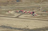
Nerlerit Inaat from Harris Fjeld IATA: CNP – ICAO: BGCO Summary Operator Mittarfeqarfiit Serves Ittoqqortoormiit Elevation AMSL 45 ft / 14 m Coordinates 70°44′35″N 022°39′02″W / 70.74306°N 22.65056°WCoordinates: 70°44′35″N 022°39′02″W / 70.74306°N 22.65056°W Website Map Location in Greenland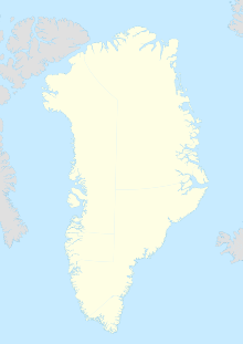
 BGCO
BGCORunways Direction Length Surface m ft 18/36 1,000 3,281 Gravel Source: Danish AIS[1] Nerlerit Inaat Airport (Kalaallisut: Mittarfik Nerlerit Inaat, Danish: Constable Pynt Lufthavn) (IATA: CNP, ICAO: BGCO) is an airport in the Sermersooq municipality in eastern Greenland. It is located on Jameson Land and serves the town of Ittoqqortoormiit, approximately 40 km (25 mi) to the south-east. The airport can serve STOL aircraft. A Bell 222 helicopter of Air Greenland is permanently housed at the airport, linking it with Ittoqqortoormiit Heliport. The helicopter also provides search and rescue capabilities within the surrounding area, and can be chartered for transport.
Contents
Airlines and destinations
 Terminal building
Airlines Destinations Air Greenland Ittoqqortoormiit[2] Air Iceland Kulusuk, Reykjavík-domestic[3] Relocation
The airport may be relocated to a new site on Liverpool Land closer to Ittoqqortoormiit, between the settlement and Uunarteq cape (Danish: Kap Tobin) to the south, thus eliminating the need for helicopter transfers.[4]
Expeditions
The airport acts as stopping off point for a number of expeditions into Jameson Land and Northeast Greenland National Park. Areas such as Renland have only just been visited,[5] or have had no known visitors.
In summer 2004 the airport was the destination of an arctic trip by two German microlight pilots flying a Flight Design CT2K light aircraft.[6]
References
- ^ BGCO – Nerlerit Inaat Airport (PDF). Greenlandic Aeronautical Information Publication from Statens Luftfartsvæsen (CAA-DK).
- ^ "Booking system". Air Greenland. http://book.airgreenland.com/. Retrieved 9 June 2010.
- ^ Air Iceland Timetable
- ^ "Øget trafik i Nationalparken" (in Danish). Sermitsiaq. 9 March 2010. http://sermitsiaq.gl/politik/article112438.ece. Retrieved 17 May 2010.
- ^ Expedition report
- ^ "In a microlight aircraft to Greenland" (German)
Airports and heliports in Greenland Airports Aasiaat · Ilulissat · Kangerlussuaq · Kulusuk · Maniitsoq · Narsarsuaq · Nerlerit Inaat · Nuuk · Paamiut · Qaanaaq · Qaarsut · Sisimiut · Upernavik

Primary heliports Alluitsup Paa · Ittoqqortoormiit · Nanortalik · Narsaq · Qaqortoq · Qasigiannguit · Qeqertarsuaq · Tasiilaq · Uummannaq
District heliports Aappilattoq (Kujalleq) · Aappilattoq (Qaasuitsup) · Akunnaaq · Ammassivik · Attu · Iginniarfik · Ikamiut · Ikerasaarsuk · Ikerasak · Ilimanaq · Illorsuit · Innaarsuit · Isortoq · Kangaatsiaq · Kangersuatsiaq · Kitsissuarsuit · Kullorsuaq · Kuummiit · Moriusaq · Narsarmijit · Niaqornaarsuk · Niaqornat · Nuugaatsiaq · Nuussuaq · Qeqertaq · Saattut · Saqqaq · Savissivik · Sermiligaaq · Siorapaluk · Tasiusaq (Kujalleq) · Tasiusaq (Qaasuitsup) · Tiniteqilaaq · Ukkusissat · Upernavik Kujalleq
Military and research NEEM Camp · Pituffik (Thule Air Base) · Summit Camp
Categories:- Airports in Greenland


Wikimedia Foundation. 2010.