- Poway, California
-
City of Poway — City — Twin Peaks above Poway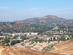
LogoMotto: The City in the Country Location in San Diego County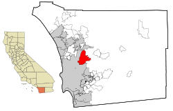
Coordinates: 32°57′46″N 117°02′09″W / 32.96278°N 117.03583°WCoordinates: 32°57′46″N 117°02′09″W / 32.96278°N 117.03583°W Country  United States
State  California
County San Diego Incorporated December 1, 1980 Government - Type Council-Manager - Mayor Don Higginson - City Manager Penny Riley - Deputy Mayor Jim Cunningham - City Council Merrilee Boyack
Dave Grosch
John MullinArea[1] - Total 39.165 sq mi (101.438 km2) - Land 39.079 sq mi (101.214 km2) - Water 0.086 sq mi (0.223 km2) 0.22% Elevation 515 ft (157 m) Population (2010) - Total 47,811 - Density 1,220.8/sq mi (471.3/km2) - Demonym Powegian Time zone PST (UTC-8) - Summer (DST) PDT (UTC-7) ZIP codes 92064, 92074 Area code(s) 858 FIPS code 06-58520 GNIS feature ID 1661258 Website http://www.ci.poway.ca.us/ Poway (
 /ˈpaʊ.eɪ/) is a city in San Diego County, California. Originally an unincorporated community in San Diego County, Poway officially became a city in December 1980. Even though Poway lies geographically in the middle of San Diego County, most consider its relative location as north county inland. Poway's rural roots gave rise to its slogan "The City in the Country." As of the 2010 census the city had a population of 47,811. The ZIP code is 92064.
Poway is located at 32°58′12″N 117°2′19″W / 32.97°N 117.03861°W (32.969895, -117.038479).[2] which lies north of the city of San Diego and south of the city of Escondido. Some nearby communities of San Diego include Rancho Bernardo, Sabre Springs, Scripps Ranch, Rancho Penasquitos, and in the county to the east, the community of Ramona. According to the United States Census Bureau, the city has a total area of 39.3 square miles (102 km2). 39.2 square miles (102 km2) of it is land and 0.1 square miles (0.26 km2) of it (0.25%) is water.
Contents
History
Artifacts such as arrow heads, spear points, metates, grinding stones, and pottery found along the bed of Poway Creek all indicate an early Diegueño presence. Various pictographs adorn many of Poway's boulders, and modern techniques suggest that these paintings date back to the 16th century or earlier. Poway's contemporary history began in the late 18th century, when padres from the Mission San Diego de Alcalá kept cattle in the valley.
Documents of Mission San Diego de Alcala record the name of the valley as "Paguay" as early as 1828. Although there is a disagreement on the meaning of "Paguay," the generally accepted translation signifies "the meeting of little valleys" or "end of the valley."[3] Some controversy also surrounds the spelling of the name Poway, historically it was also written as Paguai, Paui, Pauai, Pauy, and Powaii[citation needed] . The name of the valley of Poway (Pauwai) is derived from the language of the Diegueno and Luiseno Indians who roamed the area for several hundred years before the Spaniards came. Traces of these Native Americans still remain. In Diegueño, the area is known as Pawiiy.[4]
For approximately a century, Poway served as a stock range for the mission, until settlers began to come to the valley for farming purposes in the late antebellum period. Few records of this time have survived, and not until 1894 and the inception of the Poway Progress did the town's history become a thing of record. In 1887, about 800 people lived and farmed in Poway. Around the turn of the century Poway farmers had moderate success in the production and vending of fruit, grain, and dairy products. Expansion, however, failed to follow agricultural success. Though the farmers prospered, the town existed in a static state for decades, varying only slightly in population, demographics, crop selection, and the like.
Poway has a creek and fertile soil, but the lack of easily available water prevented the settlement from attracting large-scale farmers and the accompanying population growth. Not until 1954 did the town establish the Poway Municipal Water District, which utilizes water from the Colorado River Aqueduct to irrigate all of Poway's 10,000 acres (40 km2). When water came to the town, people did as well. In 1957, following the sewer system's completion, developers built housing tracts, and modern Poway grew from there. In 1980 Poway incorporated and officially became the City of Poway (nicknamed "the City in the Country") rather than a part of San Diego. Poway no longer depends on agriculture for its primary source of income, and has instead transitioned into a residential community for those who work for employers in and around the San Diego area. According to a recent state government estimate, the population of Poway has grown since that last census to 50,542.[5]
Agriculture
Though many residents today mistake Poway for an old Western-style cowboy town, its original roots lie in agriculture. The Homestead Act of 1862 encouraged Westward migration, and accordingly many of Poway's first white settlers came to farm. The fecund soil proved well-suited to a variety of crops, including peaches, Muscat grapes, apricots, pears, hay, and alfalfa. Some farmers captured swarms of wild bees and cultivated honey. Dairying also proved lucrative. Most families kept a cow for milk and butter, chickens for eggs and meat, and perhaps a hog to sustain them while they farmed. Crops sold well around the San Diego area. Between the seasons of 1894 and 1896, the Poway Progress reported bits of agricultural information such as:
- Muscat grapes are beginning to ripen, and the San Diego market is getting a supply of the fine article Poway always produces. ... The season has been a prolific one for bees, thirty of forty stands the present season from a single captured swarm a year or two ago. ... The peach is a good article, and Poway produces it to perfection. Poway pears will compare with any grown in the state.[citation needed]
The success of these crops depended on the annual winter rainfall, however, and so remained subject to variations in precipitation until the establishment of the Poway Municipal Water District in 1954. With water readily available, the town's farming interest shifted to two principal crops, avocados and citrus fruits. Ironically, despite the relative success of these ventures, Poway ceased to exist as a farming town once the water needed to make it a true agricultural haven appeared. With water came new residents, and the former farm town transformed into a locale full of small commercial businesses and modest shopping centers.
Religion
The Community Church of Poway, the town's first church, has remained in operation since 1887, making it the house of worship with the longest continual operation in San Diego County [1]. It is now affiliated with the United Church of Christ [2]. Today, Catholics, Lutherans, Methodists, Presbyterians, and Mormons constitute the majority of Poway's religious demographic. There are two Catholic Churches in Poway, St. Michael's [3] and St. Gabriel's [4]. There is also a small Jewish community, with a Reform and a Conservative temple as well as a Chabad. A Sikh temple, one of several in San Diego County, is found in Poway. Two Kingdom Halls of Jehovah's Witnesses are located in Poway. There are five congregations of The Church of Jesus Christ of Latter-day Saints located in Poway that meet in three meetinghouses.
Education
Poway established its school district in 1871, but did not have a schoolhouse until 1885, when a one-room schoolhouse was built at Midland Road about a 2-3 minute walk south of the Templar's Hall. The site is still in use today as an elementary school (Kindergarten through 5th grade), though it was torn down and rebuilt in 1945, and again in 2004-2006. First through eighth graders were included in one classroom. Children learned to read and write using slates, and eventually progressed to study subjects such as arithmetic, spelling, English, language (German or Latin), grammar, history, and geography. Students did not usually attend high school, and had to travel to Escondido if they wished to do so. In 1909, only three students from Poway graduated from high school. Women who went on to more school from there usually had teaching ambitions. Education, while compulsory and considered a worthwhile pastime, had few far-reaching applications for Poway's farmers' children. Enrollment in the Poway School first through eighth grades did not reach 100 until 1932.
Today, the Poway Unified School District (PUSD) has grown to more than 30 elementary, middle (6th through 8th grades), and high (9th through 12th grades) schools, and even has a home-schooling program. PUSD has a record of high performance[citation needed], and one of its students, Anurag Kashyap (an eighth grader at the time), became the 2005 National Spelling Bee Champion after winning on the word "appoggiatura". The City of Poway and Poway Unified formed a partnership to improve Poway's sports fields. Deputy Mayor Jim Cunningham was instrumental in the refurbishing of three sports fields. ( Midland Fields, Garden Elementary at Community Park, and Arbilitos Soccer Park. ).
Transportation
Poway's transportation history parallels that of early California. In 1888 the first stagecoach began to service the towns from San Diego to Escondido, including Poway. The stage made one stop in town, at the Poway Post Office, and also delivered mail to the farmers who would wait along the road for its arrival. The men would trot alongside the coach and inquire as to the state of the mail, and thus receive letters without requiring it to stop. Eight to ten passengers could accompany the stagecoach on its three-day journey for a modest $1.00 fee, or purchase a round trip for the bargain price of $1.50. The route itself, though not treacherous when passing through Poway, did pose a significant challenge to the team and driver at various points. Windy mountain trails often caused the stage to turn over, spilling both mail and passengers onto the rocky turf. The city of San Diego discontinued the stage line in 1912, when the advent of the automobile facilitated an easier and less time-consuming method of mail delivery. Poway established a County Road Station in 1920, to oil and maintain the roads so that automobiles could use them with ease. The road station remained in operation until 1961, when Poway achieved an 80% paved road rate. To this day, though, the town still boasts a number of dirt roads, for use by cars, horses, bikers, pedestrians, and hikers. Portions of what is currently Pomerado Road, a major north/south artery, were once U.S. Route 395 in California[5].
Railroad incident
Perhaps the most famed incident in Poway's transportation history comes from an event that never actually took place. The story goes as follows: in October 1895, representative from the Pacific Beach Railroad Company approached the citizens of Poway with the prospect of directing their railroad route through the center of town. A.K. Cravath and C.B. Boyd, company superintendents, met with town leaders and discussed the prospect, piquing the community's interest, as the Poway Progress reportage of November 23, 1895 demonstrates:
Superintendent Boyd of the PBRC returned recently from an extended trip throughout the east… he says the prospects of a largely increased tourist traffic during the coming season are especially good. As the years go by, Southern California is becoming more and more advertised, and Mr. Boyd says that everywhere he heard people talking of this region and not forgetting to place San Diego on the itinerary of their proposed travels. The prospects for the extension of the road to Santa Maria, he says are brighter than ever and the road will undoubtedly be built and in running order within a year.
The newspaper's editor, L. E. Kent, met with Boyd and Cravath on many occasions, and obviously caught the flavor of their sales patter. His enthusiasm for the subject of the railroad, based on repeated assurances from the PBRC that the cars could not fail to run, spread like wildfire to the townspeople. On the first of December the town held a "Railroad Social" wherein, according to plan, the PBRC representatives would meet with the entire town and, after a considerable amount of entertainment and hubbub, present the railroad contract to the townspeople for their approval and signatures. The night began without a hitch. According to the December 7 Poway Progress, "a program of good and appropriate things was provided by local talent, which furnished fun and amusement to all. Following the entertainment, a sumptuous supper was served free to the hungry crowd, after which games and youthful antics continued into the late hours" (31). The "entertainment", according to the evening's program, published by the newspaper the following morning, surpassed all expectations. Local residents performed vocal duets, played the violin and the organ, and even sang a "Railroad Song" en masse. Perhaps the most telling entertainment came in the form of a "recitation" by Flora Kent, L.E. Kent's wife, who composed an original poem on the subject and performed it for the crowd. Her proud husband esteemed his wife's literary talents so highly that he published the full text of her poem in the Progress the next day. The following excerpts (two out of a total six stanzas) give an adequate representation of the work's flavor:
- Have you heard the news, Josiar?
- I declare, it makes me young,
- It sets my heart on fire,
- And loosens my old tongue,
- And I feel jest like a talkin'
- and shoutin' jest for fun,
- For I shan't do no more walkin'
- When the cars begin to run.
- …Then Hip Hurrah! for old Poway,
- Her slumber has been long,
- But every dog must have its day,
- And every bird its song.
- Then let us give a mighty cheer,
- And shout, "The battle's won."
- For she's a comin', don't you fear,
- The cars is bound to run!
The poem gives an excellent indication of Poway's general excitement concerning the new railroad. The comment that Poway's "slumber has been long", especially, suggests that Poway residents recognize the sleepiness and overall torpor of their town, and long for an agent such as the railroad to awaken them from their doze into a new world of economic prosperity. This new reality, however, seemed dubious when, on the very night of the Railroad Social, with all the town's residents in attendance, the PBRC representatives failed to materialize. "There was one disappointment that shadowed the whole affair—" the Progress reports: "the nonappearance of the gentlemen who were expected to be present to give the railroad talk, setting for the plans, purpose, and contracts of the enterprise." The fact that the superintendents never attended the contract signing should have, perhaps, indicated to the Powegians that the PBRC did not act entirely in good faith concerning the venture. The same newspaper article, though, states "In justice to the gentlemen named, we are authorized to state that they fully intended to be present at the social, but other engagements prevented them—explanations promised." At this time in the venture, Poway had collectively given upwards of $100,000 worth of bonds and land to the PBRC. Gullible as the superintendents doubtless expected to find them, Poway residents continued to pursue the railroad project for another year in its entirety, with the paper constantly reporting news such as this, in July 1896. (39)
Although there is at present a death-like sentence as to our railroad project, we are glad to note indications that the enterprise is not abandoned, nor at a standstill entirely. Mr. Boyd… [said] that they would "get there" without fail. He gave the impression, in short, that the construction of the road can be depended on.
Not until October 1896 did Poway finally abandon hope for the project and demand its money back. Remarkably, the sum of $85,000 worth of land and notes came back into the town's coffers. The financial losses incurred by the townspeople, then, did not prove devastating, but the town's spirit never fully recovered from the blow. L.E. Kent himself took the news so poorly, having had the personal assurances of Cravath and Boyd many times, and having staked his journalistic reputation, such as it was, on these assurances, that he only continued to publish the Poway Progress until 1897, one year after the railroad fiasco concluded. After all, progress did not seem imminent in Poway's future any longer. When news of the coming railroad spread, an English firm, Baird and Chapin, came to the valley and laid out a subdivision plan called Piermont. A plan filed in 1887 shows such elegant names as Devon, Norwalk, Aubrey, Edgemoor, York, Rydal, Windsor and Midland Avenues. Residential areas were planned around small parks: Ashton Court, Chatham Court, Hampton Court, St. Alban's Court and many others. Poway's new railroad would bring the grandeur, elegance, and cultivation that the town currently lacked, and the developers named the areas accordingly. When the railroad did not materialize, though, the valley began to lose some of its settlers, and the developers left as well. Poway existed in a stagnant inertia for close to three quarters of a century before water revitalized the town.
Water
Poway's greatest change started in the 1950s when water came to the valley. On January 29, 1954 an election was held on the formation of the Poway Municipal Water District, which passed with an overwhelming majority of 210 ayes to 32 nayes. At a second election on March 25, 1954, the citizens voted to annex to the San Diego County Water Authority. At a third election held April 22, 1954, the citizens voted to incur bonded debt of $600,000 to build a water system. The first water delivery was made in July, 1954 to Gordon's Grocery on Garden Road. In 1972 Poway Dam was built to provide a dependable supply of water.
In 1957, the Pomerado County Water District was organized to provide sewer service to 1,610 acres (6.5 km2) along Pomerado Road. In 1959 the first subdivision homes were built and sold as Poway Valley Homes and Poway's population began to climb. On December 1, 1980, the City of Poway incorporated and the two districts, Poway Municipal Water and Pomerado County Water, became part of the City structure. The district issued a restriction for watering lawns. It allowed people to water their lawns three days a week each week. But, soon after a year or two, these restrictions were lifted.
Recent events
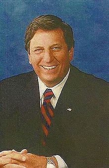 Mickey Cafagna, Poway's mayor for over a decade
In 1980, Poway incorporated and became the City of Poway, an entity separate from the County of San Diego. It justifies its nickname of the "City in the Country" despite its burgeoning population because it has been designated a "Tree City" [6] for the last decade. Poway is the location of the Blue Sky Ecological Reserve, Lake Poway, and many minor hiking and horse riding trails. Major portions of the town were evacuated during both the 2003 Cedar Fire and 2007 Witch Creek Fire. In 2004, the City of Poway adopted the 1st Light Armored Reconnaissance Battalion, 1st Marine Division, based out of nearby Camp Pendleton. The Fred L. Kent Post 7907 of the Veterans of Foreign Wars has been the official go-between with the battalion, which has been redeployed at least once to Iraq since its adoption.
On April 11, 2009, Poway's Mayor Michael "Mickey" Cafagna died due to complications resulting from kidney cancer. A real-estate broker and contractor, Cafagna was born in Detroit, Michigan and had been a resident of Poway for 34 years. He sat on the city council from 1992 until his death, elected mayor in 1998 (he was in his third term at the time of his death). His achievements were many including the construction of Poway City Hall, the continued development of the business park, and establishing relationships with the business community and the Chamber of Commerce. He has been acknowledged as "a true leader and friend" and lauded for his efforts to improve the city, as well as for his leadership during the Cedar and Witch Creek fires.[6][7] When Cafagna's illness prevented him from performing his mayoral duties, the Deputy Mayor, Don Higginson, acted as Mayor of Poway. Cafagna was survived by Sharon Green Cafagna, his wife of 43 years, their two children and their five grandchildren. He is buried at Dearborn Memorial Park in Poway.[8]
The City Council met on April 28, 2009 to decide whether to appoint a new mayor to replace Cafagna, or to hold an election in November. The City Council appointed the Deputy Mayor Don Higginson as mayor of Poway until the Cafagna's term expires in November 2010. A 43-year resident of Poway, Higginson has served on the City Council since 1986 and was in fact Cafagna's predecessor as mayor of the city.[9]
Carl Kruse was appointed on May 26, 2009 to fill the council vacancy created by the selection of Higginson as mayor. This was the second time Kruse has been named to fill a council vacancy, the first being in 1982, when he was selected to replace founding councilmember Clyde Rexrode, who had been reelected in spite of having died on the eve of the election.[10][dead link] Carl Kruse. said he would not run after he was appointed but did and lost in the November 2010 election.
In the June 2010 election, councilwoman Betty Rexford was recalled by 78.01 percent of voters. A first in Poway's history, the recall followed after the city spent $360,000 to settle a lawsuit filed by two of her neighbors. The suit accused Rexford of using her position to interfere with the plaintiffs' plans to build on their Creek Road properties, which are on each side of a home owned by Rexford and her husband. The lawsuit never went to trial, but the councilwoman nevertheless was recalled by voters.[11]
Geography
According to the United States Census Bureau, the city covers an area of 39.2 square miles (102 km2), 99.78% of it land, and 0.22% of it water.
Climate
Poway experiences a semi-arid climate (Köppen climate classification BSh).
Climate data for Poway Month Jan Feb Mar Apr May Jun Jul Aug Sep Oct Nov Dec Year Average high °C (°F) 19.4
(66.9)19.4
(66.9)21.1
(70.0)22.2
(72.0)24.4
(75.9)27.2
(81.0)27.8
(82.0)27.2
(81.0)25.0
(77.0)22.2
(72.0)20.0
(68.0)19.4
(66.9)22.9 Average low °C (°F) 6.7
(44.1)7.2
(45.0)9.4
(48.9)11.7
(53.1)13.9
(57.0)16.1
(61.0)16.7
(62.1)16.1
(61.0)12.8
(55.0)8.9
(48.0)7.8
(46.0)6.1
(43.0)11.1 Precipitation mm (inches) 64
(2.52)58.7
(2.31)62.7
(2.47)22.4
(0.88)7.1
(0.28)2.3
(0.09)1.3
(0.05)1.8
(0.07)6.6
(0.26)12.2
(0.48)29.7
(1.17)35.3
(1.39)304
(11.97)Source: [12] Education
Poway High School
Poway High School, home of the Titans, is known for its wrestling, lacrosse, baseball, and football teams. The Titan wrestling team, coached by Wayne Branstetter since 1978, has won 25 consecutive CIF San Diego Section Championships, placed in the top five statewide 20 times, and won four CIF State Wrestling Team Championships, in 1986, 1999, 2005 and 2009. The Poway High Varsity Football team, coached by Damian Gonzalez won the CIF San Diego Division I semifinals in 2006 and won the CIF San Diego Division I title in 2008, going undefeated (12-0) for the first time in the school's history. The Poway High Varsity Baseball team won the CIF Division I championship in 2006, 2008 and 2009. The Poway High Girls Varsity Basketball team won the CIF Division I championship in 2008 and set a school record with 29 wins in 2009. The Emerald Brigade, the school's marching band, competes throughout the year and has won sweepstakes and top honors. The Emerald Brigade won top honors in regional and national competitions in the late 1990s. The Poway High School Choir department sends its top choirs (Die Lieders and Women's & Men's Ensembles) to compete nationally, acquiring top awards in various major cities around the United States, including San Francisco, Washington D.C., Chicago, Illinois and Orlando, Florida. Tom DeLonge of the bands, Blink-182 and Angels & Airwaves, attended Poway High School. Also Zach Porter, Nathan Darmody, Cameron Quiseng of Allstar Weekend. Many highly accomplished leaders attended Poway High School including biotechnology pioneer and acclaimed scientist David Goeddel.
Demographics
Historical populations Census Pop. %± 1960 1,921 — 1970 9,422 390.5% 1980 32,263 242.4% 1990 43,516 34.9% 2000 48,044 10.4% 2010 47,811 −0.5% source:[13][14] 2010
The 2010 United States Census[15] reported that Poway had a population of 47,811. The population density was 1,220.7 people per square mile (471.3/km²). The racial makeup of Poway was 36,781 (76.9%) White, 783 (1.6%) African American, 265 (0.6%) Native American, 4,853 (10.2%) Asian, 106 (0.2%) Pacific Islander, 2,944 (6.2%) from other races, and 2,079 (4.3%) from two or more races. Hispanic or Latino of any race were 7,508 persons (15.7%).
The Census reported that 47,261 people (98.8% of the population) lived in households, 284 (0.6%) lived in non-institutionalized group quarters, and 266 (0.6%) were institutionalized.
There were 16,128 households, out of which 6,493 (40.3%) had children under the age of 18 living in them, 10,523 (65.2%) were opposite-sex married couples living together, 1,675 (10.4%) had a female householder with no husband present, 742 (4.6%) had a male householder with no wife present. There were 580 (3.6%) unmarried opposite-sex partnerships, and 111 (0.7%) same-sex married couples or partnerships. 2,469 households (15.3%) were made up of individuals and 1,185 (7.3%) had someone living alone who was 65 years of age or older. The average household size was 2.93. There were 12,940 families (80.2% of all households); the average family size was 3.23.
The population was spread out with 11,948 people (25.0%) under the age of 18, 3,912 people (8.2%) aged 18 to 24, 10,496 people (22.0%) aged 25 to 44, 15,555 people (32.5%) aged 45 to 64, and 5,900 people (12.3%) who were 65 years of age or older. The median age was 41.3 years. For every 100 females there were 97.1 males. For every 100 females age 18 and over, there were 94.5 males.
There were 16,715 housing units at an average density of 426.8 per square mile (164.8/km²), of which 12,000 (74.4%) were owner-occupied, and 4,128 (25.6%) were occupied by renters. The homeowner vacancy rate was 1.1%; the rental vacancy rate was 5.5%. 35,111 people (73.4% of the population) lived in owner-occupied housing units and 12,150 people (25.4%) lived in rental housing units.
2000
The census[16] of 2000, there were 48,044 people, 15,467 households, and 12,868 families residing in the city. The population density was 1,224.8 inhabitants per square mile (473.0/km²). There were 15,714 housing units at an average density of 400.6 per square mile (154.7/km²). The racial makeup of the city was 82.85% White, 7.46% Asian, 1.67% African American, 0.48% Native American, 0.28% Pacific Islander, 3.27% from other races, and 3.99% from two or more races. Across all races 10.35% are Hispanic or Latino.[17]
There were 15,467 households out of which 47.0% had children under the age of 18 living with them, 68.8% were married couples living together, 10.5% have an unmarried female householder, and 16.8% were non-families. 12.6% of all households were made up of individuals and 4.7% had someone living alone who was 65 years of age or older. The average household size was 3.08 people and the average family size was 3.35 people.
In the city the population was spread out with 30.7% under the age of 18, 7.1% from 18 to 24, 28.1% from 25 to 44, 25.5% from 45 to 64, and 8.6% who were 65 years of age or older. The median age was 37 years. For every 100 females there were 97.0 males. For every 100 females age 18 and over, there were 93.9 males.
The median income for a household in Poway is $92,083, and the median income for a family was $103,972, making it the 25th most expensive zip code in the United States (as of a 2007 estimate[18]). Males had a median income of $53,322 versus $52,742 for females. The per capita income for the city was $29,788. About 3.1% of families and 4.3% of the population were below the poverty line, including 4.9% of those under age 18 and 3.7% of those age 65 or over.
According to estimates by the San Diego Association of Governments, the median household income of Poway in 2005 was $96,474 (not adjusted for inflation). When adjusted for inflation (1999 dollars; comparable to Census data above), the median household income was $78,340.
Economy
Top employers
According to the City's 2009 Comprehensive Annual Financial Report,[19] the top employers in the city are:
# Employer # of Employees 1 Geico Direct 1,500 2 Poway Unified School District 1,462 3 Pomerado Hospital 743 4 Cohu 650 5 Sysco San Diego 456 6 Digirad 434 7 CoreLogic Credco 416 8 Wal-Mart 340 9 City of Poway 310 10 Mitchell 1 265 Parks and reserves
Aubrey Park - 13544 Aubrey Street, Poway. Located between Midland Avenue and Community Avenue. This park encompasses 8.5 acres (34,000 m2) and includes four softball fields, a snack shop, walking trails, picnic areas and native tree groves.[20] T[20]
Blue Sky Ecological Reserve - 16275 Espola Road, Poway [7]
Old Poway Park - 14134 Midland Road, Poway.[8] Home of Poway-Midland Railroad [9] Home of the Poway Historical and Memorial Society [10]
Starridge Park - 13745 Carriage Rd, Poway.
Community Park - 13094 Civic Center Drive, Poway [11]. Home of Dog Park,[12] the community pool,[13] and a skate park.[14]
Lake Poway - 14644 Lake Poway Rd. Poway.[15]
Hiking Trails [16]
Kumeyaay-Ipai Interpretive Center at Pauwai - 13104 Ipai Waaypuk Trail (formerly Silver Lake Drive), Poway.[17]
Sycamore Canyon Preserve and Goodan Ranch - Over 10 miles (16 km) of trails (which connect to the neighboring city of Santee), available for hiking, biking and horseback riding, also has a Visitor Center.[21]Politics
In the state legislature Poway is located in the 36th Senate District, represented by Republican Joel Anderson, and in the 75th Assembly District, represented by Republican Nathan Fletcher. Federally, Poway is located in California's 52nd congressional district, which has a Cook PVI of R +9[22] and is represented by Republican Duncan D. Hunter.
Notable natives, current and former residents
- Mark Hoppus, Bassist/singer of Blink-182 and +44
- Tom DeLonge, Guitarist/singer of Blink-182, Box Car Racer and Angels & Airwaves
- Scott Raynor, original drummer of Blink-182
- David Kennedy, Guitarist of Box Car Racer, Angels & Airwaves
- Chris Armes, Guitarist/singer of Agent 51
- Chris Lewis, Guitarist/singer of Pivit, Fenix TX, and Denver Harbor.
- Bruce Bochy, former Padres manager and current San Francisco Giants manager
- Fletcher Bowron, mayor of Los Angeles, California
- Merrilee Boyack, published author
- Jeromy Burnitz, Major League Baseball outfielder
- Brandon Call, Actor Step By Step & Baywatch
- Luis Castillo, current defensive end for the San Diego Chargers
- Antonio Gates, tight end for the San Diego Chargers
- David Goeddel, Biotechnology pioneer and acclaimed scientist
- Tony Gwynn, retired San Diego Padres star, manager of SDSU Aztecs baseball team
- David Justice, former Major League baseball player
- Anurag Kashyap, winner of the 2005 Scripps National Spelling Bee and 2008 Teen Jeopardy Tournament
- Jesse Taylor, MMA fighter
- Matt Wilhelm, current Middle Linebacker for the Green Bay Packers
- Shaun Phillips, current outside linebacker for the San Diego Chargers
- Shawne Merriman, current outside linebacker for the Buffalo Bills
- Mark Risley, Emmy-winning director
- Unwritten Law, Punk rock band known for song "CPK", meaning "Crazy Poway Kids".
- Christy Hemme, former WWE Diva and current TNA Knockout
- Charley Hoffman, PGA Tour professional
- Bobby Lee, actor, stand up comedian.
- Tom Brunansky, Outfielder, World Series Champion Minnesota Twins
- Dave Rickards, Radio Host, Host on Dave, Shelly, and Chainsaw Radio Show KFMB-FM
- Zach Porter, Cameron Quiseng, Nathan Darmody, and Michael Martinez, members of the band Allstar Weekend
- LaDainian Tomlinson, current running back for the New York Jets
See also
References
- ^ U.S. Census
- ^ "US Gazetteer files: 2010, 2000, and 1990". United States Census Bureau. 2011-02-12. http://www.census.gov/geo/www/gazetteer/gazette.html. Retrieved 2011-04-23.
- ^ http://www.ci.poway.ca.us/index.aspx?page=763
- ^ Ted Couro and Christina Hutcheson (1973). Dictionary of Mesa Grande Diegueño. Malki Museum Press, Morongo Indian Reservation, Banning, California
- ^ http://web.archive.org/web/20060622233327/http://www.dof.ca.gov/HTML/DEMOGRAP/e-1press.pdf estimate
- ^ POWAY: Mayor dies after battle with cancer : North County Times - Californian 04-11-2009
- ^ City of Poway : City of Poway News : City of Poway Says Goodbye to Mayor Mickey Cafagna
- ^ Michael "Mickey" Cafagna (1943 - 2009) - Find A Grave Memorial
- ^ City of Poway : City of Poway News : City of Poway Appoints New Mayor, Applications Being Accepted to Fill City Council Vacancy
- ^ Carl R. Kruse, a retired banker who served two City Council terms in the 1980s, was unanimously appointed May 26 night to fill an 18-month term on the council.
- ^ Rexford recall vote winning
- ^ "Poway historic weather averages". Intellicast. http://www.intellicast.com/local/history.aspx?location=USCA0900. Retrieved 19 February 2010.
- ^ "CENSUS OF POPULATION AND HOUSING (1790-2000)". U.S. Census Bureau. http://www.census.gov/prod/www/abs/decennial/index.html. Retrieved 2010-07-30.
- ^ Census numbers from 1960 to 1980 were enumerated prior to incorporation.
- ^ All data are derived from the United States Census Bureau reports from the 2010 United States Census, and are accessible on-line here. The data on unmarried partnerships and same-sex married couples are from the Census report DEC_10_SF1_PCT15. All other housing and population data are from Census report DEC_10_DP_DPDP1. Both reports are viewable online or downloadable in a zip file containing a comma-delimited data file. The area data, from which densities are calculated, are available on-line here. Percentage totals may not add to 100% due to rounding. The Census Bureau defines families as a household containing one or more people related to the householder by birth, opposite-sex marriage, or adoption. People living in group quarters are tabulated by the Census Bureau as neither owners nor renters. For further details, see the text files accompanying the data files containing the Census reports mentioned above.
- ^ "American FactFinder". United States Census Bureau. http://factfinder.census.gov. Retrieved 2008-01-31.
- ^ Census 2000 Demographic Profile: Poway, CA
- ^ Poway, California US Census Bureau Retrieved 2010-02-19
- ^ City of Poway CAFR
- ^ a b Bengtson, Stacey (2007-01-15). "Poway: Aubrey named an award-winning park". San Diego Business Journal 28 (3): 17. ISSN 8750-6890.
- ^ http://www.poway.org/Index.aspx?page=352
- ^ "Will Gerrymandered Districts Stem the Wave of Voter Unrest?". Campaign Legal Center Blog. http://www.clcblog.org/blog_item-85.html. Retrieved 2008-02-10.
External links
Categories:- Cities in San Diego County, California
- Incorporated cities and towns in California


Wikimedia Foundation. 2010.