- Geneseo, New York
Infobox Settlement
official_name = Geneseo
settlement_type = Town
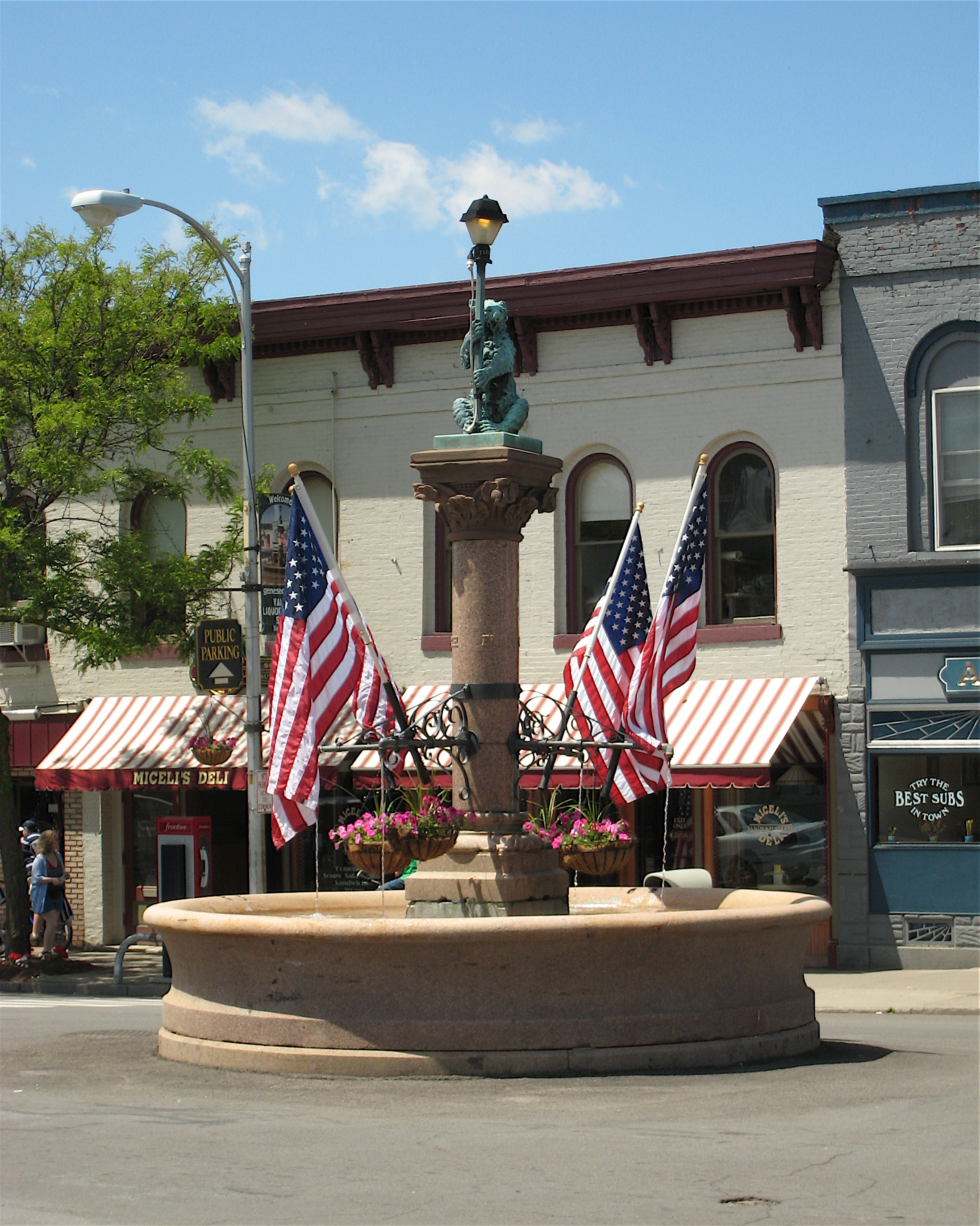
image_caption = The Bear Fountain sits in the center of Geneseo's Main Street. In this picture, it is decorated with flags forMemorial Day .
imagesize = 192px
pushpin_
pushpin_label_position = bottom
subdivision_type = Country
subdivision_name = flagcountry|United States
subdivision_type1 = State
subdivision_name1 = flagcountry|New York
subdivision_type2 = County
subdivision_name2 = Livingston
leader_title = Mayor
leader_name = Dr. Richard B. Hatheway [cite web | title = Mayor Richard B. Hatheway | url = http://www.geneseony.org/trustees/hatheway.html | accessdate = 2007-10-10 | publisher = The Village of Geneseo | work = The Village of Geneseo Board of Trustees]
established_title = Town established
established_date = 1789
established_title2 = Village incorporated
established_date2 = 1832
unit_pref = imperial
area_magnitude =
area_total_km2 = 117.1
area_land_km2 = 113.9
area_water_km2 = 3.2
area_total_sq_mi = 45.2
area_land_sq_mi = 44.0
area_water_sq_mi = 1.2
area_blank1_title = Village
area_blank1_sq_mi = 2.79
elevation_m = 277
elevation_ft = 909
latd = 42 | latm = 47 | lats = 45 | latNS = N
longd = 77 | longm = 48 | longs = 49 | longEW = W
population_as_of = 2000
population_total = 9654
population_density_sq_mi = 219.6
population_blank2_title = Village
population_blank2 = 7579
population_density_blank2_sq_mi = 2718.3
timezone = Eastern (EST)
utc_offset = -5
timezone_DST = EDT
utc_offset_DST = -4
postal_code_type = ZIP code
postal_code = 14454
area_code = 585
blank_name = FIPS code
blank_info = 36-28629
blank1_name = GNIS feature ID
blank1_info = 0978991
website = [http://www.geneseony.org/ GeneseoNY.org]Geneseo (pron-en|ˌdʒɛnɨˈsiːoʊ) is the name of a
town and avillage in Livingston County in westernNew York ,USA . The town's population is approximately 9,600, of which about 7,600 live in the village. The English name "Geneseo" is ananglicization of the Iroquois name for the earlier Iroquois town there, "Gen-nis-he-yo" (which means "beautiful valley").cite book | last = Cook | first = William R. | coauthors = Daniel J. Schultz | title = Around Geneseo | publisher = Arcadia Publishing | date = 2004 | isbn = 0-7385-3496-X]The Town of Geneseo is south of Rochester, New York. Entirely contained within it is the Village of Geneseo, the
county seat of Livingston County, which is located in the western part of the town at the junction of Routes 39, 63, and U.S. 20A. A portion of the village—theGeneseo Historic District —was designated aNational Historic Landmark by theUnited States Department of the Interior in 1991.History
Pre-revolution
The site of Geneseo was the largest Seneca village, and a center of power for the
Iroquois nation. It was also the "bread basket" of the tribe, with orchards, vineyards, and fields of maize and vegetables.During the
American Revolution , the Seneca joined the British and the Tories against the colonists who were fighting for independence. Raids by this alliance from the west was a major threat to the American cause, and General Washington sent theSullivan Expedition to neutralize the Iroquois. As Sullivan's army approached Geneseo, with their "scorched earth" policy the Senecas repeatedly fell back. However, they did extract some damage, as a large Seneca party was successful in ambushing one of Sullivan's scouting parties, carrying them as prisoners to Geneseo and torturing them to death. When Sullivan's troops arrived and found the mutilated bodies, they were enraged, and became very thorough in their destruction of anything that could support the Iroquois. From Geneseo and environs about 5,000 Seneca refugees fled to British-heldFort Niagara , where they spent one of the coldest winters of record, with much loss of life, in camps outside the fort with only the small amount of supplies that the British could spare.Post-revolution
The town was established in 1789, prior to the formation of Livingston County. The settlement of Geneseo by the colonists began shortly after the arrival of James and William Wadsworth in 1790. The brothers came to the Genesee Valley from
Connecticut as agents of their uncle, Colonel Jeremiah Wadsworth, to care for and sell the land he had purchased. The Wadsworths were participants in the negotiations of theTreaty of Big Tree between Robert Morris and the Senecas at the site of Geneseo in 1797.Geneseo, as well as nearby Mount Morris, were part of
The Morris Reserve that Morris held back from his sale of much of westernNew York to theHolland Land Company .The Village of Geneseo became the
county seat of Livingston County in 1821 and was incorporated in 1832. The State Normal School, now SUNY Geneseo, was opened in 1871. A portion of the village was designated aNational Historic Landmark by theUnited States Department of the Interior in 1991.By 1835 the village consisted of 83 families and the streets were Main, Second, North, South, Center and Temple Hill. The village grew steadily and in the 1850s Elm Street was opened. With the advent of the State Normal School in 1871, there was a new surge of development and Oak Street was opened in the late 1880s. The private Temple Hill Academy, part of which still stands on Temple Hill Road, educated
Chester A. Arthur among others.During the Civil War, Union soldiers trained at Camp Union, located at what is now the corner of Lima Road and Rorbach Lane. During World War II, a
prisoner-of-war camp was built in Geneseo; it housed mostly Italian soldiers.Present day
In its addition of Geneseo to the
National Register of Historic Places in 1991, theNational Park Service said, [cite web | url = http://tps.cr.nps.gov/nhl/detail.cfm?ResourceId=1728&ResourceType=District | title = Geneseo Historic District | accessdate = 2007-07-25 | date = 1991-07-17 | work = National Historic Landmarks Program | publisher = United States National Park Service] quote|One of the most remarkably preserved villages in northwestern New York, Geneseo is one of the best examples of "picturesque" architecture and town planning as expounded by American landscape architectAndrew Jackson Downing (1815–1852) in his enormously popular and influential books. The cohesive quality of the surviving town displays a textbook of styles and is almost unique in American architectural history. The relatively sophisticated and imposing structures included in the district reflect the village's early–19th century prosperity as a market place for the valley's farming communities.The valley of the Genesee is wide and fertile, with some of the best agricultural land in New York, but it was very prone to flooding, and Geneseo suffered several bad floods until the
United States Army Corps of Engineers ' construction of theMount Morris Dam upstream of the community in the 1950s. Agriculture is now a large contributor to Geneseo's economy. Geneseo is also used by many as abedroom community for jobs in nearby Rochester. The Village of Geneseo is governed by aMayor and four trustees.The town can be roughly divided into three geographies: the village has a small-town atmosphere, much of Route 20A is heavily commercialized, and the majority of the town's area is farmland. One of the main issues faced by the community today is
urban sprawl . The increasing presence ofbig-box store s on Route 20A has been welcomed by some residents, who appreciate the convenience of nearby retailers, and discouraged by others, who oppose thesuburbanization of the small town.The Geneseo Airport (D52) is a general aviation airport west of the village, on the Wadsworth farm. It was established during July 1969, and is now used for approximately 20 aircraft operations each day. [cite web | title = Geneseo Airport | url = http://www.airnav.com/airport/D52 | date = 2007-07-05 | accessdate = 2007-08-17 | work = Airports | publisher = AirNav.com] Since 1980, it has hosted groups restoring and operating historic military aircraft—originally the National Warplane Museum, and now the
1941 Historical Aircraft Group . Anairshow is held annually on the field, during the second weekend in July.The Association for the Preservation of Geneseo (APOG) is a civic organization dedicated to preserving, improving, and restoring the places of civic, architectural, and historic interest to Geneseo, Livingston County, New York and to educate members of the community to their architectural and historical heritage. Additional aims and purposes are to encourage others to contribute their knowledge, advice, and financial assistance. [cite web | title = Association for the Preservation of Geneseo | url = http://www.geneseoapog.com/ | accessdate = 2007-08-17 | publisher = Association for the Preservation of Geneseo]
The Geneseo Central School District encompasses Geneseo and Groveland, and consists of Geneseo Central School, which graduates approximately 75 students each year. [cite web | title = About Us | url = http://geneseocsd.org/about.cfm | accessdate = 2007-08-17 | publisher = Geneseo Central School District]
In July 2007,
Money Magazine ranked Geneseo 10th of 25 on its list of best places to meet and fall in love. [cite web | url = http://money.cnn.com/galleries/2007/moneymag/0707/gallery.BPTL_most_singles.moneymag/10.html | title = Where the singles are | last = Cox | first = Jeff | accessdate = 2007-07-25 | publisher = CNN Money]Geography
According to the
United States Census Bureau , the town has a total area of 45.2square mile s (117.1km² ), of which, 44.0 square miles (113.9 km²) of it is land and 1.2 square miles (3.2 km²) of it (2.74%) is water. The village has a total area of 2.79 square miles (7.22 km²), all of which is land.The
Genesee River defines the western town line, andConesus Lake defines the eastern town line.Interstate 390 and U.S. Route 20A pass through the town.New York State Route 39 andNew York State Route 63 are two important north-south highways passing through the village, andNew York State Route 256 is a north-south route along the shore of Conesus Lake.The town contains a number of hamlets on the western shore of Conesus Lake. From north to south along Route 256 (West Lake Road), they are: [cite web | title = Town of Geneseo Map | publisher = Livingston County Planning Department | year = 2003 | month = July | accessdate = 2007-12-19 | format = JPEG | url = http://www.geneseony.org/Town%20Map.jpg]
* Sleggs Landing
* Eagle Point
* Sacketts Harbor
* Wadsworth Cove
* Long Point
* Long Point Cove
* Cottonwood CoveGeneseo has a mild climate; summers typically bring temperatures between 60–80°F and winters average 15–35°.
Infobox Weather
location = Geneseo, New York
single_line = yesJan_Hi_°F = 32 | Jan_REC_Hi_°F = 67
Feb_Hi_°F = 34 | Feb_REC_Hi_°F = 72
Mar_Hi_°F = 42 | Mar_REC_Hi_°F = 84
Apr_Hi_°F = 55 | Apr_REC_Hi_°F = 91
May_Hi_°F = 68 | May_REC_Hi_°F = 92
Jun_Hi_°F = 77 | Jun_REC_Hi_°F = 95
Jul_Hi_°F = 81 | Jul_REC_Hi_°F = 99
Aug_Hi_°F = 79 | Aug_REC_Hi_°F = 97
Sep_Hi_°F = 71 | Sep_REC_Hi_°F = 94
Oct_Hi_°F = 60 | Oct_REC_Hi_°F = 83
Nov_Hi_°F = 48 | Nov_REC_Hi_°F = 77
Dec_Hi_°F = 37 | Dec_REC_Hi_°F = 71Jan_Lo_°F = 16 | Jan_REC_Lo_°F = -24
Feb_Lo_°F = 16 | Feb_REC_Lo_°F = -13
Mar_Lo_°F = 24 | Mar_REC_Lo_°F = -9
Apr_Lo_°F = 34 | Apr_REC_Lo_°F = 11
May_Lo_°F = 45 | May_REC_Lo_°F = 29
Jun_Lo_°F = 55 | Jun_REC_Lo_°F = 35
Jul_Lo_°F = 59 | Jul_REC_Lo_°F = 45
Aug_Lo_°F = 57 | Aug_REC_Lo_°F = 37
Sep_Lo_°F = 50 | Sep_REC_Lo_°F = 28
Oct_Lo_°F = 39 | Oct_REC_Lo_°F = 21
Nov_Lo_°F = 32 | Nov_REC_Lo_°F = 11
Dec_Lo_°F = 22 | Dec_REC_Lo_°F = -7Jan_Precip_inch = 1.78
Feb_Precip_inch = 1.53
Mar_Precip_inch = 2.33
Apr_Precip_inch = 2.82
May_Precip_inch = 2.85
Jun_Precip_inch = 3.51
Jul_Precip_inch = 2.78
Aug_Precip_inch = 3.31
Sep_Precip_inch = 3.46
Oct_Precip_inch = 2.58
Nov_Precip_inch = 2.63
Dec_Precip_inch = 2.23source = The Weather Channelcite web | title = Monthly Averages for Geneseo, NY | publisher = The Weather Channel | url = http://www.weather.com/outlook/health/allergies/wxclimatology/monthly/graph/14454 | accessdate = 2007-12-19]
accessdate = 2007-12-19Demographics
Town
As of the
census of 2000, there were 9,654 people, 2,523 households, and 1,303 families residing in the town. Thepopulation density was 219.6 people per square mile (84.8/km²). There were 2,698 housing units at an average density of 23.7 persons/km² (61.4 persons/sq mi). The racial makeup of the town was 93.91% White, 1.48%African American , 0.11% Native American, 2.61%Asia n, 0.04% Pacific Islander, 0.69% from other races, and 1.15% from two or more races. 2.19% of the population were Hispanic orLatino of any race.There were 2,523 households out of which 23.5% had children under the age of 18 living with them, 41.3% were married couples living together, 8.3% have a woman whose husband does not live with her, and 48.4% were non-families. 26.0% of all households were made up of individuals and 9.6% had someone living alone who was 65 years of age or older. The average household size was 2.53 and the average family size was 2.92.
In the town the population was spread out with 11.9% under the age of 18, 51.3% from 18 to 24, 15.2% from 25 to 44, 13.2% from 45 to 64, and 8.5% who were 65 years of age or older. The median age was 22 years. For every 100 females there were 72.3 males. For every 100 females age 18 and over, there were 68.4 males.
The median income for a household in the town was $40,660, and the median income for a family was $62,206. Males had a median income of $42,218 versus $25,969 for females. The
per capita income for the town was $15,303. 29.8% of the population and 8.7% of families were below the poverty line. Out of the total people living in poverty, 12.2% are under the age of 18 and 5.5% are 65 or older.Village
As of the
census of 2000, there were 7,579 people, 1,718 households, and 730 families residing in the village. Thepopulation density was 2,718.3 people per square mile (1,049.5/km²). There were 1,780 housing units at an average density of 246.5 persons/km² (638.4 persons/sq mi). The racial makeup of the village was 92.7% White, 1.8%African American , 0.1% Native American, 3.3%Asia n, 0.0% Pacific Islander, 0.9% from other races, and 1.2% from two or more races. 2.6% of the population were Hispanic orLatino of any race.There were 1,718 households, out of which 19.7% had children under the age of 18 living with them, 31.8% were married couples living together, 9.0% have a woman whose husband does not live with her, and 57.5% were non-families. 28.4% of all households were made up of individuals and 10.8% had someone living alone who was 65 years of age or older. The average household size was 2.52 and the average family size was 2.86.
In the village the population was spread out with 8.6% under the age of 18, 63.5% from 18 to 24, 10.9% from 25 to 44, 9.3% from 45 to 64, and 7.8% who were 65 years of age or older. The median age was 21.1 years. For every 100 females there were 65.6 males. For every 100 females age 18 and over, there were 62.5 males.
The median income for a household in the village was $30,438, and the median income for a family was $59,500. Males had a median income of $40,915 versus $26,382 for females. The
per capita income for the village was $12,239. 41.7% of the population and 14.1% of families were below the poverty line. Out of the total people living in poverty, 19.4% are under the age of 18 and 7.0% are 65 or older.References
External links
* [http://www.geneseony.org/ Town and Village of Geneseo] (official website)
* [http://www.geneseony.com/ GeneseoNY.com]
* [http://www.geneseoapog.com/ Association for the Preservation of Geneseo]
* [http://www.geneseo.edu/ State University of New York, College at Geneseo]
* [http://www.1941hag.org/ 1941 Historical Aircraft Group]
* [http://www.wadsworth.pls-net.org Wadsworth Library] – Geneseo's public library
* [http://www.geneseocsd.org/ Geneseo Central Schools] – Geneseo's K-12 School
* [http://www.geneseevalleyconservancy.org/ Genesee Valley Conservancy] – Working to conserve open space in the Village and Town of Geneseo.

Wikimedia Foundation. 2010.