- Morro Bay, California
-
City of Morro Bay — City — Skyline of Morro Bay, with Morro Rock in the center Location in San Luis Obispo County and the state of California
Coordinates: 35°22′45″N 120°51′12″W / 35.37917°N 120.85333°WCoordinates: 35°22′45″N 120°51′12″W / 35.37917°N 120.85333°W Country  United States
State  California
County San Luis Obispo Founded 1870 Government – Mayor Janice Peters Area[1] – Total 10.322 sq mi (26.734 km2) – Land 5.303 sq mi (13.734 km2) – Water 5.019 sq mi (13.000 km2) 48.63% Elevation 62 ft (19 m) Population (2010) – Total 10,234 – Density 991.5/sq mi (382.8/km2) Time zone Pacific Standard Time (UTC-8) – Summer (DST) Pacific Daylight Time (UTC-7) ZIP codes 93442-93443 Area code(s) 805 FIPS code 06-49362 GNIS feature ID 1661062 Website http://www.morro-bay.ca.us/ Morro Bay is a waterfront city in San Luis Obispo County, California, United States. As of the 2010 census, the city population was 10,234, down from 10,350 at the 2000 census.
Contents
History
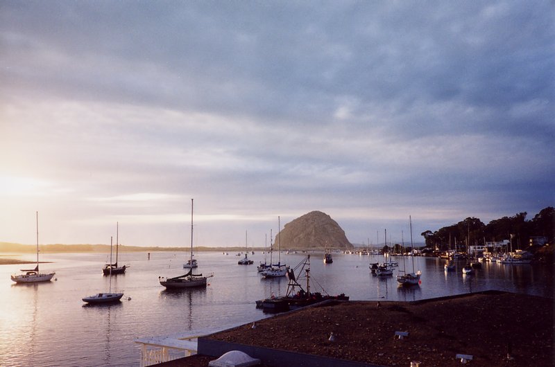
 The boat docks of Morro Bay, with Morro Rock on the left
The prehistory of Morro Bay relates to Chumash settlement, particularly near the mouth of Morro Creek. At least as early as the Millingstone Horizon thousands of years before present, there was an extensive settlement along the banks and terraces above Morro Creek.[2]
Morro Rock was named in 1542 by Portuguese navigator Juan Rodríguez Cabrillo, who explored the Pacific Coast for Spain. Cabrillo called the rock El Moro because it resembled the head of a Moor, the people from North Africa known for the turbans they wore. However, the dictionary definition for the Spanish word "morro" ("pebble") is also consistent with the shape of the rock, and so the term morro is frequently used wherever such a distinctive rock-like mountain is found within the Spanish speaking world.
The first recorded Filipino immigrants to America arrived at Morro Bay on October 18, 1587, from the Spanish galleon Nuestra Señora de Esperanza.[3][4]
While governed by Mexico, large land grants split the surrounding area into cattle and dairy ranchos. These ranchos needed shipping to bring in dry goods and to carry their crops, animals, and other farm products to cities. Thus, Morro Bay grew.
The town of Morro Bay was founded by Franklin Riley in 1870 as a port for the export of dairy and ranch products. He was instrumental in the building of a wharf which has now become the Embarcadero. During the 1870s, schooners could often be seen at the Embarcadero picking up wool, potatoes, barley, and dairy products.
Since the beginning of the 20th century, the town has been a center for beach holidays. Tourism is the city's largest industry. The most popular beach is on the north side of Morro Rock, north of the harbor. There are also excellent beaches north and south of the town which are now owned by the State of California.
In the 1940s, Morro Bay developed an abalone fishing industry. Having peaked in 1957, stocks of abalone have now declined signicantly due to overfishing,[5] it remains a fishing port for halibut, sole, rockfish, albacore, and many other species for both commercial and sport vessels. The town now combines the fishing industry with coastal tourism. In addition, oysters are farmed artificially in the shallow back bay.
A portion of Morro Bay is also designated as a state and national bird sanctuary. This means it is illegal to kill or harm a bird in that portion of Morro Bay. It is also a state and national estuary. Much of Morro Bay is a state wildlife refuge where waterfowl hunting is conducted during the season and is one of the few areas in California where Pacific Brant are pursued. Recently, Morro Bay was also declared a California Marine Reserve by the California Fish and Game Commission.
Geography
Morro Bay is located at 35°22′45″N 120°51′12″W / 35.37917°N 120.85333°W (35.379043, -120.853354).[6] Morro Bay 35°20′16″N 120°51′05″W / 35.33778°N 120.85139°W is also the name of the large estuary that is situated along the northern shores of the bay itself. The larger bay on which the local area lies is Estero Bay, which also encompasses the communities of Cayucos and Los Osos. The city of Morro Bay is 20 km (12 mi) northwest of San Luis Obispo and is located on Highway 1. Los Osos Creek discharges into Morro Bay.
According to the United States Census Bureau, the city has a total area of 10.3 square miles (27 km2), of which, 5.3 square miles (14 km2) of it is land and 5.0 square miles (13 km2) of it (48.63%) is water.
Morro Rock

Morro Rock Main article: Morro RockThe town's most striking feature is Morro Rock, a 576 foot high volcanic plug. Morro Rock stands at the entrance to the harbor, and a causeway connects it with the shore. Previously, it was surrounded by water, but the northern channel was filled in to make the harbor. The Rock, as locals call it, was quarried from 1889 to 1969. There is no public access to the rock itself because it is a reserve for the locally endangered peregrine falcon. However, the area around the base of Morro Rock can be visited. Every few years, someone is caught trying to climb the rock. Climbers risk more than fines or jail time as the rocks that form Morro Rock are loose and fall down regularly. The base of Morro Rock is littered with fallen boulders.
Morro Rock is one in a series of similar plugs that stretch in a line inland called the Nine Sisters. It is possible that the landscape moved over a volcanic hot spot through the ages.
Morro Bay Harbor
 The Morro Bay docks with Morro Rock in the background.
Morro Bay is a natural embayment with an artificial harbor constructed by the U.S. Army Corps of Engineers. It is the only all-weather small craft commercial and recreational harbor between Santa Barbara and Monterey. Morro Rock was originally surrounded by water, but the Army built a large artificial breakwater and road across the north end of the harbor, linking Morro Rock and the mainland. Some of the rock used for this and for the artificial breakwaters was quarried from Morro Rock itself. Other rock was imported by barge from Catalina Island. The bay extends inland and parallels the shore for a distance of about 6.4 km (4 miles) south of its entrance at Morro Rock. Morro Bay is recognized for protection by the California Bays and Estuaries Policy.[7]
Only relatively small craft are capable of passing the harbor channel. A large natural sandspit, augmented by breakwaters, protects the harbor from the Pacific Ocean to the west. At its northern end, remains of a bridge that used to connect the shore with the sandspit can be seen. Morro Bay Harbor's channel silts up and must be dredged every three to four years. Previously, the Shark Inlet connected the back bay to the ocean. Some have proposed reopening it to slow the sedimentation that is filling up the bay. There has also been work on reducing erosion in the Chorro Creek watershed to reduce the amount of sediment coming into the bay to form bottom layers of bay mud. Chorro Creek is the bay's largest tributary. It forms an estuary in the back bay between Morro Bay and Los Osos. The second largest tributary, and the only other significant one, is Los Osos Creek, which empties into the far south end of the back bay.
 A flock of Western Gulls in Morro Bay, California
Mariners are strongly urged to seek local advice prior to making use of the channel, especially when whitecaps or wind-blown water is evident or a small craft advisory is in effect, which is very often. The United States Coast Guard regards the harbor as one of the most dangerous in the entire nation, while others put it in the top six on the West Coast of the United States. In 1995, the Army Corps of Engineering deepened and expanded the channel to improve safety. From 1979 to 1987, 21 lives were lost in boating accidents alone. However, many additional deaths have resulted from sightseers and fisherman being swept off the rocks of the breakwater surrounding Morro Rock. They often approach too closely to the waves and are caught off guard when a big wave set comes in. The slippery and jagged rocks only add to the danger. Public access to the breakwater has been revoked and those who venture beyond the signs do so at their own peril. Coast Guard Station Morro Bay operates two small vessels. Limited transient vessel services are available. Yachtsmen may wish to contact the Morro Bay Yacht Club. A public boat launch ramp is available at the far south end of the Embarcadero.
The back bay, roughly anything south of the Morro Bay State Park Marina, is very shallow. However, there is some slightly deeper water in the channels. The largest channel continues from the bay's main channel, winding its way towards Los Osos, on the southern end of the bay. The second largest breaks off from the largest about halfway to Los Osos and takes an extremely windy route to the sandspit. A few small channels on the landward side formed by runoff meet the largest channel as well. The narrow, unmarked channels are very hard to navigate and are filled with eel grass, which can snag the boat or clog the propeller. They are easiest to find at low tide, but if the tide is too low, the boat may run aground because the channels are only a few feet deeper than the surrounding water. An alternative to searching for the channels is to cross at very high tide.
During World War II, there was a U.S. Navy base on the north side of Morro Rock where sailors were trained to operate LCVPs. The breakwater on the southwest side of the Rock was built in 1944-45 to protect the LCVPs entering and leaving the harbor. Soldiers from Camp San Luis Obispo would come to Morro Bay and practice loading into the LCVPs. Many of those men were at Normandy on D-Day.
Climate
Morro Bay experiences a Mediterranean climate (Köppen climate classification Csb).
Climate data for Morro Bay, California Month Jan Feb Mar Apr May Jun Jul Aug Sep Oct Nov Dec Year Record high °F (°C) 89
(32)87
(31)92
(33)100
(38)98
(37)101
(38)91
(33)98
(37)102
(39)107
(42)97
(36)90
(32)107
(42)Average high °F (°C) 62
(17)62
(17)62
(17)63
(17)63
(17)64
(18)65
(18)66
(19)68
(20)69
(21)67
(19)62
(17)64 Average low °F (°C) 42
(6)43
(6)44
(7)45
(7)48
(9)50
(10)52
(11)53
(12)54
(12)53
(12)47
(8)41
(5)48 Record low °F (°C) 23
(−5)25
(−4)28
(−2)33
(1)33
(1)39
(4)35
(2)40
(4)41
(5)37
(3)31
(−1)22
(−6)22
(−6)Precipitation inches (mm) 3.49
(88.6)3.69
(93.7)3.66
(93)1.12
(28.4)0.34
(8.6)0.07
(1.8)0.03
(0.8)0.09
(2.3)0.37
(9.4)0.70
(17.8)1.54
(39.1)2.51
(63.8)17.61
(447.3)Source: http://www.intellicast.com/local/history.aspx?location=USCA0733 Marine Protected Areas
Morro Bay State Marine Recreational Management Area and Morro Bay State Marine Reserve are marine protected areas offshore from Morro Bay. Like underwater parks, these marine protected areas help conserve ocean wildlife and marine ecosystems.
Economy
A number of tourist attractions are found along the shoreline and the streets closest to it, especially the Embarcadero, including restaurants, shops and parks.
Demographics
2010
The 2010 United States Census[8] reported that Morro Bay had a population of 10,234. The population density was 991.5 people per square mile (382.8/km²). The racial makeup of Morro Bay was 8,909 (87.1%) White, 44 (0.4%) African American, 92 (0.9%) Native American, 258 (2.5%) Asian, 9 (0.1%) Pacific Islander, 613 (6.0%) from other races, and 309 (3.0%) from two or more races. Hispanic or Latino of any race were 1,526 persons (14.9%).
The Census reported that 10,073 people (98.4% of the population) lived in households, 36 (0.4%) lived in non-institutionalized group quarters, and 125 (1.2%) were institutionalized.
There were 4,844 households, out of which 919 (19.0%) had children under the age of 18 living in them, 1,972 (40.7%) were opposite-sex married couples living together, 405 (8.4%) had a female householder with no husband present, 217 (4.5%) had a male householder with no wife present. There were 330 (6.8%) unmarried opposite-sex partnerships, and 35 (0.7%) same-sex married couples or partnerships. 1,808 households (37.3%) were made up of individuals and 783 (16.2%) had someone living alone who was 65 years of age or older. The average household size was 2.08. There were 2,594 families (53.6% of all households); the average family size was 2.70.
The population was spread out with 1,530 people (15.0%) under the age of 18, 815 people (8.0%) aged 18 to 24, 2,264 people (22.1%) aged 25 to 44, 3,200 people (31.3%) aged 45 to 64, and 2,425 people (23.7%) who were 65 years of age or older. The median age was 48.9 years. For every 100 females there were 95.8 males. For every 100 females age 18 and over, there were 93.6 males.
There were 6,320 housing units at an average density of 612.3 per square mile (236.4/km²), of which 2,583 (53.3%) were owner-occupied, and 2,261 (46.7%) were occupied by renters. The homeowner vacancy rate was 3.3%; the rental vacancy rate was 6.3%. 5,218 people (51.0% of the population) lived in owner-occupied housing units and 4,855 people (47.4%) lived in rental housing units.
2000
As of the 2000 census,[9] there were 10,350 people, 4,986 households, and 2,612 families residing in Morro Bay. The population density was 2,006.9 people per square mile (774.4/km²). There were 6,251 housing units at an average density of 1,212.1 per square mile (467.7/km²). The racial makeup of the city was 89.44% White, 0.68% African American, 0.95% Native American, 1.81% Asian, 0.09% Pacific Islander, 4.10% from other races, and 2.95% from two or more races. Hispanic or Latino of any race were 11.43% of the population.
There were 4,986 households out of which 16.7% had children under the age of 18 living with them, 40.5% were married couples living together, 8.3% had a female householder with no husband present, and 47.6% were non-families. 38.0% of all households were made up of individuals and 16.4% had someone living alone who was 65 years of age or older. The average household size was 2.04 and the average family size was 2.65.
In the city the population was spread out with 15.1% under the age of 18, 8.4% from 18 to 24, 25.4% from 25 to 44, 26.8% from 45 to 64, and 24.2% who were 65 years of age or older. The median age was 46 years. For every 100 females there were 91.3 males. For every 100 females age 18 and over, there were 89.8 males.
The median income for a household in the city was $34,379, and the median income for a family was $43,508. Males had a median income of $31,073 versus $25,576 for females. The per capita income for the city was $21,687. About 8.1% of families and 13.0% of the population were below the poverty line, including 16.9% of those under age 18 and 5.8% of those age 65 or over.
Morro Bay High School is the only school in Morro Bay, California that offers education for grade level 9th-12th.[10]
Politics
In the state legislature Morro Bay is located in the 15th Senate District, represented by Republican Abel Maldonado, and in the 33rd Assembly District, represented by Republican Sam Blakeslee. Federally, Morro Bay is located in California's 23rd congressional district, which has a Cook PVI of D +9[11] and is represented by Democrat Lois Capps.
Power plant
 the Dynegy Power Plant, from Morro Bay Beach
The Dynegy power plant, previously owned by Pacific Gas and Electric Company, Duke Energy, and LSPower (PG&E), plays a large role in Morro Bay, and in providing electricity to the Central Coast and the Central Valley of California (primarily Fresno and Bakersfield). Its future is currently, as of 2007, uncertain. The current plant was built in the 1950s, and Dynegy wishes to modernize it with a new combined cycle plant. Due primarily to economics, the plant is currently operating at relatively low capacity factors (approximately 5%) under contract with PG&E. The plant is currently staffed with 44 employees. A portion of the city's budget comes from tax on the natural gas the plant burns. The outfall lease with the city was recently approved by the majority of the city council. Activists are opposed to the new plant. The United States Environmental Protection Agency (EPA) and the courts are currently wrestling with how to interpret the Clean Water Act (CWA) and its applicability to power plants. The EPA has ruled that the local Regional Water Quality Control Boards are responsible for ensuring that the current and the future plant are permitted and regulated. If the proposed plant is eventually built, the old power plant and its 450 ft. tall stacks will be removed. The modernized plant would be located slightly northwest of the existing plant, and its stacks would be much shorter (145 ft).
Notable residents
- George Ramos, born in East Los Angeles in 1948, died in Morro Bay in July 2011 at age 63. Ramos earned a Purple Heart during the Vietnam War and won three Pulitzers for the Los Angeles Times, before he returned to his alma mater Cal Poly San Luis Obispo as the head of the journalism department in 2003. At the time of his death, Ramos was a tenured professor of journalism at Cal Poly and editor of Cal Coast News.[12]
- Jack LaLanne, Born in San Francisco, Sept. 26, 1914 - Died in Morro Bay of pnemonia, Jan. 23, 2011, age 96. Mr. LaLanne was an originator of the diet and exercise movement in the USA.
- Camille Katz born 8/29/2011 famous singer went to Morro Bay high school graduating class of 2001.
- Greg Garman drummer for Selena Gomez.
References
- ^ U.S. Census
- ^ [C.Michael Hogan (2008) Morro Creek, ed. by A. Burnham http://www.megalithic.co.uk/article.php?sid=18502]
- ^ Mercene, Floro L. (2007). Manila Men in the New World: Filipino Migration to Mexico and the Americas from the Sixteenth Century. The University of the Philippines Press. pp. 161. ISBN 9715425291. http://books.google.com/books?id=OSqhZphG_gQC&pg=PA38. Retrieved July 1, 2009.
- ^ [1]
- ^ [Susan McBride and Fred F. Conte, California Abalone Aquaculture, California Aquaculture, University of California, Davis http://aqua.ucdavis.edu/dbweb/outreach/aqua/ASAQ-A10.PDF]
- ^ "US Gazetteer files: 2010, 2000, and 1990". United States Census Bureau. 2011-02-12. http://www.census.gov/geo/www/gazetteer/gazette.html. Retrieved 2011-04-23.
- ^ State Water Resources Control Board Water Quality Control Policy for the Enclosed Bays and Estuaries of California (1974) State of California
- ^ All data are derived from the United States Census Bureau reports from the 2010 United States Census, and are accessible on-line here. The data on unmarried partnerships and same-sex married couples are from the Census report DEC_10_SF1_PCT15. All other housing and population data are from Census report DEC_10_DP_DPDP1. Both reports are viewable online or downloadable in a zip file containing a comma-delimited data file. The area data, from which densities are calculated, are available on-line here. Percentage totals may not add to 100% due to rounding. The Census Bureau defines families as a household containing one or more people related to the householder by birth, opposite-sex marriage, or adoption. People living in group quarters are tabulated by the Census Bureau as neither owners nor renters. For further details, see the text files accompanying the data files containing the Census reports mentioned above.
- ^ "American FactFinder". United States Census Bureau. http://factfinder.census.gov. Retrieved 2008-01-31.
- ^ [2]
- ^ "Will Gerrymandered Districts Stem the Wave of Voter Unrest?". Campaign Legal Center Blog. http://www.clcblog.org/blog_item-85.html. Retrieved 2008-02-10.
- ^ "George Ramos dies at 63; former Times reporter and columnist". Los Angeles Times. http://www.latimes.com/news/obituaries/la-me-george-ramos-20110725,0,5098115.story. Retrieved 2008-08-06.
External links
- Central Coast Sport Fishing Morro Bay
- City of Morro Bay
- Information about Morro Bay
- Morro Bay Guide to Nature, Recreation, Politics, Culture
- Morro Bay High School
- Morro Bay Merchants Association
Municipalities and communities of San Luis Obispo County, California Cities Arroyo Grande | Atascadero | Grover Beach | Morro Bay | Paso Robles | Pismo Beach | San Luis Obispo
CDPs Avilla Beach | Blacklake | Callender | Cambria | Cayucos | Creston | Edna | Garden Farms | Lake Nacimiento | Los Berros | Los Osos | Los Ranchos | Nipomo | Oak Shores | Oceano | San Miguel | San Simeon | Santa Margarita | Shandon | Templeton | Whitley Gardens | Woodlands
Unincorporated
communitiesAdelaida | Asuncion | Baywood-Los Osos | Bee Rock | Bern | Bromela | California Valley | Cambria Pines | Cholame | Chorro | Halcyon | Harmony | Huasna | Pozo
Categories:- Incorporated cities and towns in California
- Populated coastal places in California
- Cities in San Luis Obispo County, California
- Ports and harbors of California


Wikimedia Foundation. 2010.