- Pismo Beach, California
-
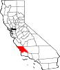
City of Pismo Beach — City — Pismo Beach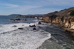 Location in San Luis Obispo County and the state of California
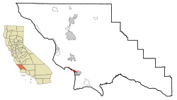
Coordinates: 35°8′54″N 120°38′53″W / 35.14833°N 120.64806°WCoordinates: 35°8′54″N 120°38′53″W / 35.14833°N 120.64806°W Country  United States
State  California
County San Luis Obispo Area[1] - Total 13.476 sq mi (34.904 km2) - Land 3.599 sq mi (9.322 km2) - Water 9.877 sq mi (25.582 km2) 73.29% Elevation 56 ft (17 m) Population (2010) - Total 7,655 - Density 568/sq mi (219.3/km2) Time zone Pacific (PST) (UTC-8) - Summer (DST) PDT (UTC-7) ZIP codes 93448-93449 Area code(s) 805 FIPS code 06-57414 GNIS feature ID 1652776 Pismo Beach is a city in San Luis Obispo County, California, United States. The population was 7,655 at the 2010 census, down from 8,551 at the 2000 census. It is part of the Five Cities Area, a term used to describe the cluster of cities that are present in that area of San Luis Obispo County.
Contents
History
Pismo Beach is a popular beach town located in southern San Luis Obispo County in the Central Coast area of California. It is located on the Rancho Pismo Mexican land grant made to José Ortega, grandson of José Francisco de Ortega (explorer), in 1840. In 1846 José Ortega sold Rancho Pismo to Isaac Sparks. John Michael Price bought most of the rancho from Isaac Sparks. Price established the town of Pismo Beach. His homestead is now Price Historical Park.[2] His home is a registered historical landmark. Pismo State Beach is named for the city of Pismo Beach. The name Pismo comes from the Chumash word for tar, which was gathered from tar springs in Price Canyon near Pismo Beach. It was a valuable product used to caulk canoes. The Pismo clam was named for the long wide beach where so many were once found. Once so abundant they were harvested with plows on the beach, giving the city the name "Clam Capitol of the World", the Pismo Clam is now greatly diminished.
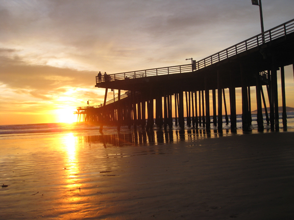
The first wharf at Pismo was built in 1882, followed by a fishing pier built in 1924. After it suffered considerable storm damage, it was replaced by the present Pismo Pier in 1985. The Pismo Pier is admired for its diamond-shaped platforms over the beach and over the water.
 Pismo Pier sunset 018 8x72
Demographics
2010
The 2010 United States Census[3] reported that Pismo Beach had a population of 7,655. The population density was 568.0 people per square mile (219.3/km²). The racial makeup of Pismo Beach was 6,976 (91.1%) White, 50 (0.7%) African American, 41 (0.5%) Native American, 203 (2.7%) Asian, 11 (0.1%) Pacific Islander, 170 (2.2%) from other races, and 204 (2.7%) from two or more races. Hispanic or Latino of any race were 715 persons (9.3%).
The Census reported that 7,642 people (99.8% of the population) lived in households, 13 (0.2%) lived in non-institutionalized group quarters, and 0 (0%) were institutionalized.
There were 3,834 households, out of which 619 (16.1%) had children under the age of 18 living in them, 1,710 (44.6%) were opposite-sex married couples living together, 267 (7.0%) had a female householder with no husband present, 102 (2.7%) had a male householder with no wife present. There were 235 (6.1%) unmarried opposite-sex partnerships, and 39 (1.0%) same-sex married couples or partnerships. 1,372 households (35.8%) were made up of individuals and 578 (15.1%) had someone living alone who was 65 years of age or older. The average household size was 1.99. There were 2,079 families (54.2% of all households); the average family size was 2.55.
The population was spread out with 1,020 people (13.3%) under the age of 18, 450 people (5.9%) aged 18 to 24, 1,555 people (20.3%) aged 25 to 44, 2,642 people (34.5%) aged 45 to 64, and 1,988 people (26.0%) who were 65 years of age or older. The median age was 51.8 years. For every 100 females there were 93.5 males. For every 100 females age 18 and over, there ere 91.4 males.
There were 5,585 housing units at an average density of 414.4 per square mile (160.0/km²), of which 2,336 (60.9%) were owner-occupied, and 1,498 (39.1%) were occupied by renters. The homeowner vacancy rate was 2.5%; the rental vacancy rate was 9.6%. 4,658 people (60.8% of the population) lived in owner-occupied housing units and 2,984 people (39.0%) lived in rental housing units.
2000
As of the census[4] of 2000, there were 8,551 people, 4,230 households, and 2,322 families residing in the city. The population density was 2,366.0 people per square mile (914.6/km²). There were 5,496 housing units at an average density of 1,520.7 per square mile (587.8/km²). The racial makeup of the city was 91.35% White, 0.60% African American, 0.71% Native American, 2.92% Asian, 0.06% Pacific Islander, 1.65% from other races, and 2.71% from two or more races. Hispanic or Latino of any race were 6.89% of the population.
There were 4,230 households out of which 17.4% had children under the age of 18 living with them, 45.1% were married couples living together, 6.4% had a female householder with no husband present, and 45.1% were non-families. 35.4% of all households were made up of individuals and 16.0% had someone living alone who was 65 years of age or older. The average household size was 2.02 and the average family size was 2.58.
In the city the population was spread out with 15.3% under the age of 18, 6.5% from 18 to 24, 25.2% from 25 to 44, 28.4% from 45 to 64, and 24.5% who were 65 years of age or older. The median age was 47 years. For every 100 females there were 93.1 males. For every 100 females age 18 and over, there were 92.3 males.
The median income for a household in the city was $46,396, and the median income for a family was $61,036. Males had a median income of $48,606 versus $30,189 for females. The per capita income for the city was $30,835. About 6.3% of families and 9.0% of the population were below the poverty line, including 10.5% of those under age 18 and 4.8% of those age 65 or over.
The population had a wave of expansion starting in the 1980s, after completion of waste water treatment facilities expansion designed by Kennedy Jenks Engineers; this lack of infrastructure had previously limited population growth.
Geography and climate
According to the United States Census Bureau, the city has a total area of 13.5 square miles (35 km2). 3.6 square miles (9.3 km2) of it is land and 9.9 square miles (26 km2) of it (73.29%) is water.
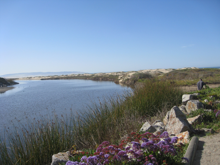
Pismo Creek enters the Pacific Ocean at Pismo Beach.
 Pismo Beach Creek taken at Addie Vacation Townhomes 10x72
Shell Beach is a populated place within the city limits of Pismo Beach, located at 35°09′19″N 120°40′21″W / 35.1552532°N 120.6723950°W.[5][6]
Climate data for Pismo Beach, California Month Jan Feb Mar Apr May Jun Jul Aug Sep Oct Nov Dec Year Record high °F (°C) 85
(29)90
(32)90
(32)101
(38)100
(38)99
(37)104
(40)108
(42)110
(43)99
(37)91
(33)92
(33)110
(43)Average high °F (°C) 65
(18)66
(19)67
(19)69
(21)70
(21)71
(22)71
(22)72
(22)73
(23)73
(23)69
(21)66
(19)69 Average low °F (°C) 43
(6)44
(7)45
(7)46
(8)47
(8)51
(11)53
(12)53
(12)53
(12)51
(11)46
(8)42
(6)48 Record low °F (°C) 24
(−4)28
(−2)23
(−5)31
(−1)30
(−1)37
(3)38
(3)39
(4)35
(2)32
(0)29
(−2)24
(−4)23
(−5)Rainfall inches (mm) 3.59
(91.2)3.87
(98.3)3.46
(87.9)1.13
(28.7)0.41
(10.4)0.07
(1.8)0.03
(0.8)0.02
(0.5)0.32
(8.1)0.62
(15.7)1.70
(43.2)2.57
(65.3)17.79
(451.9)Source: http://www.weather.com/outlook/driving/interstate/wxclimatology/monthly/graph/USCA0872 Politics
In the state legislature Pismo Beach is located in the 15th Senate District, represented by Republican Abel Maldonado, and in the 33rd Assembly District, represented by Republican Sam Blakeslee. Federally, Pismo Beach is located in California's 23rd congressional district, which has a Cook PVI of D +9[7] and is represented by Democrat Lois Capps.
Schools
 Shell Beach Elementary
Public schools
- Shell Beach Elementary School, 2100 Shell Beach Rd., Pismo Beach, CA 93449 (Grades K-6)
- Judkins Middle School, 680 Wadsworth, Pismo Beach, CA 93449 (Grades 7-8)
- High school students attend Arroyo Grande High School, 495 Valley Road, Arroyo Grande, CA 93420
Colleges and universities
- Cuesta College, San Luis Obispo
- California Polytechnic State University San Luis Obispo (Cal Poly)
Clams
Pismo Beach adopted the name "Clam Capital of the World" in the 1950s. The city holds the Clam Festival every October, complete with clam chowder competitions and a clam-themed parade. At the southern end of Price Street upon first entering Pismo Beach, a gigantic concrete clam statue greets visitors. Clamming once drew thousands of clammers to the beach during low tides and is still legal; however, due to over-harvesting by humans and the protected sea otter (which feasts on clams), few clams are to be found. An 8 inch shell of the Pismo clam (Tivela stultorum) is on display at the Pismo Beach Chamber of Commerce.
In "Ali Baba Bunny", Bugs Bunny and his travelling companion Daffy Duck emerge from a burrow, believing they have arrived at Pismo Beach "and all the clams we can eat".
In one of the later episodes of "Dragnet 1967", Frank Gannon retires to Pismo Beach and in explaining his plans to Joe Friday, he states his reason, "The clams, man. The clams."
References
- ^ U.S. Census
- ^ Price Historical Park web site
- ^ All data are derived from the United States Census Bureau reports from the 2010 United States Census, and are accessible on-line here. The data on unmarried partnerships and same-sex married couples are from the Census report DEC_10_SF1_PCT15. All other housing and population data are from Census report DEC_10_DP_DPDP1. Both reports are viewable online or downloadable in a zip file containing a comma-delimited data file. The area data, from which densities are calculated, are available on-line here. Percentage totals may not add to 100% due to rounding. The Census Bureau defines families as a household containing one or more people related to the householder by birth, opposite-sex marriage, or adoption. People living in group quarters are tabulated by the Census Bureau as neither owners nor renters. For further details, see the text files accompanying the data files containing the Census reports mentioned above.
- ^ "American FactFinder". United States Census Bureau. http://factfinder.census.gov. Retrieved 2008-01-31.
- ^ Pismo Beach Zoning Map. July 1998
- ^ "Shell Beach". Geographic Names Information System, U.S. Geological Survey. January 19, 1981. http://geonames.usgs.gov/pls/gnispublic/f?p=gnispq:3:::NO::P3_FID:1661431. Retrieved 2010-01-29.
- ^ "Will Gerrymandered Districts Stem the Wave of Voter Unrest?". Campaign Legal Center Blog. http://www.clcblog.org/blog_item-85.html. Retrieved 2008-02-10.
External links
Municipalities and communities of San Luis Obispo County, California Cities Arroyo Grande | Atascadero | Grover Beach | Morro Bay | Paso Robles | Pismo Beach | San Luis Obispo
CDPs Avilla Beach | Blacklake | Callender | Cambria | Cayucos | Creston | Edna | Garden Farms | Lake Nacimiento | Los Berros | Los Osos | Los Ranchos | Nipomo | Oak Shores | Oceano | San Miguel | San Simeon | Santa Margarita | Shandon | Templeton | Whitley Gardens | Woodlands
Unincorporated
communitiesAdelaida | Asuncion | Baywood-Los Osos | Bee Rock | Bern | Bromela | California Valley | Cambria Pines | Cholame | Chorro | Halcyon | Harmony | Huasna | Pozo
Categories:- Incorporated cities and towns in California
- Populated coastal places in California
- Cities in San Luis Obispo County, California


Wikimedia Foundation. 2010.