- New Jersey Route 55
-
This article is about the current New Jersey Route 55. For the former Route 55 in Atlantic County, see New Jersey Route 55 (pre-1953).
Route 55
Veterans Memorial Highway 
Route 55 highlighted in redRoute information Maintained by NJDOT Length: 40.54 mi[3] (65.24 km) Existed: 1969 (completed 1989)[1][2] – present Major junctions South end:  Route 47 in Maurice River Township
 Route 49 in Millville
Route 47 in Millville
 Route 56 in Vineland
 US 40 in Franklin Township
 US 322 in Harrison Township
North end:  Route 42 in Deptford Township
Highway system New Jersey State Highway Routes
Interstate and US←  Route 54
Route 56 →Route 55 is a state highway in the southern part of New Jersey, United States that is built to freeway standards. Also known as the Veterans Memorial Highway, it runs 40.54 mi (65.24 km) from an intersection with Route 47 in Port Elizabeth north to an interchange with Route 42 in Gloucester County. The Route 55 freeway serves as a main road through Cumberland and Gloucester counties, serving Millville, Vineland, and Glassboro. It is used as a commuter route north to Philadelphia and, along with Route 47, as a route from the Delaware Valley to the Jersey Shore resorts in Cape May County.
What is now Route 55 was originally proposed in the 1950s as a toll road called the Cape May Expressway that was to run from the Walt Whitman Bridge to Cape May. In 1962, the New Jersey Expressway Authority was created to build the Cape May Expressway and the Atlantic City Expressway. However, by 1965, the road to Cape May was turned over to the New Jersey Department of Transportation (NJDOT) and designated as Route 55, which was to run from Westville to Cape May Court House. The first portion of the route opened around Millville in 1969 while the section bypassing Vineland was completed in the 1970s. Route 55 was completed north to Deptford in 1989. Meanwhile, the portion between Route 47 in Port Elizabeth and the Garden State Parkway in Middle Township was canceled in 1975 due to the impact the highway would have on the surrounding environment. However, traffic jams on Route 47 during the summer months and the lack of an adequate evacuation route for the Cape May Peninsula have led officials to reexamine the possibility of extending Route 55 southward to Cape May County.
Contents
Route description
Cumberland and Salem counties
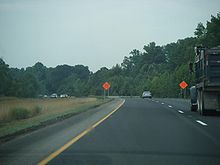
Route 55 begins at a signalized intersection with Route 47 in the Port Elizabeth section of Maurice River Township, Cumberland County, heading to the north as a two-lane undivided road through wooded areas.[3][4] At the southern terminus, the road continues south as part of Route 47. A short distance after beginning, the road widens into a four-lane divided freeway and comes to a southbound exit and northbound entrance with Schooner Landing Road.[3] Past this interchange, Route 55 enters Millville and crosses over the Manantico Creek as it heads into built-up areas. The freeway continues north to an interchange with Route 49.[3][4]
Past the Route 49 interchange, Route 55 continues through Millville, passing over County Route 552 Spur (CR 552 Spur). The route passes to the east of WheatonArts and the Creative Glass Center of America before turning northwest and crossing into Vineland, where it interchanges with CR 555.[3][4]
The freeway turns to the west past the CR 555 interchange and crosses over a Conrail Shared Assets Operations railroad line before entering Millville again.[3] At this point, the route comes to a modified cloverleaf interchange with Route 47 adjacent to the Cumberland Mall.[3][4][5] From Route 47, the freeway enters forested areas again and makes a turn to the north, crossing back into Vineland. In Vineland, it interchanges with CR 552 near the South Jersey Health Care Regional Medical Center.[3][4] This exit also serves Cumberland County College to the east.[6]
Route 55 continues between rural areas near the Maurice River to the west and development to the east, coming to a cloverleaf interchange with Route 56.[4] Past this interchange, the route passes over a Winchester & Western Railroad line before crossing over CR 540. Farther north, a modified cloverleaf interchange serves CR 674 (Garden Road), which provides access to the northern part of Vineland. Past the Garden Road interchange, Route 55 continues through farmland and woodland, passing to the east of Rudys Airport.[4] The freeway crosses Scotland Run and briefly runs through Pittsgrove Township in Salem County.[3][4]
Gloucester County
Route 55 continues northwest into Franklin Township, Gloucester County, and reaches a cloverleaf interchange with U.S. Route 40 (US 40). Past this interchange, the freeway heads north, crossing over CR 538.[3][4] Route 55 comes to a diamond interchange with Little Mill Road before entering Clayton and turning to the west. A short distance later, Route 55 continues into Elk Township and comes to an interchange with CR 553.[3]
The route continues north into Glassboro, where it has an interchange with CR 641.[3] Past this interchange, Route 55 crosses into Harrison Township and meets US 322 and CR 536 at a cloverleaf interchange.[3][4] US 322 heads east into Glassboro and serves Rowan University.[7]
Past the US 322 interchange, the freeway continues through agricultural areas and enters Mantua Township, where it turns northeast and crosses under CR 553 Alternate.[3][4] Route 55 passes under a Conrail Shared Assets Operations railroad line before intersecting CR 553 again at a modified cloverleaf interchange.[3] This interchange provides access to The Broadway Theatre of Pitman.[8]
Past CR 553, the route turns north again and passes near more suburban surroundings, briefly entering Washington Township before crossing into Deptford Township. In Deptford Township, Route 55 comes to a cloverleaf interchange with Route 47.[3][4] Northbound Route 47 heads toward the main campus of Gloucester County College in Sewell.[9] It crosses CR 534 before coming to a trumpet interchange with Deptford Center Road that provides access to CR 621 and the Deptford Mall.[3][4][10] Past this interchange, Route 55 passes under CR 544 and CR 621 before merging into the northbound direction of the Route 42 freeway.[3]
History
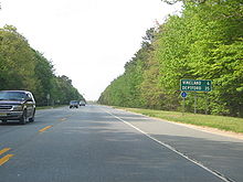 The southernmost portion of Route 55 in Maurice River Township that is a two-lane undivided road
Following the completion of the Walt Whitman Bridge in the 1950s, two toll freeways were proposed to connect the bridge to Atlantic City and Cape May.[11] In 1962, the New Jersey Expressway Authority Act was signed into law. This act created the New Jersey Expressway Authority, which was to manage both the Atlantic City and Cape May expressways.[12]
While the Atlantic City Expressway was completed by the authority in 1965, the Cape May Expressway was turned over to the state about this time.[13][14] The Cape May Expressway was designated Route 55 and legislated to run from US 130 in Westville to US 9 near Cape May Court House.[14] This proposed freeway was projected to cost $90 million (equivalent to $626 million in 2011[15]) and be completed in 1975.[16]
In 1969, the first segment of Route 55 opened between Maurice River Township and the Vineland-Millville border, connecting to Route 47 at both ends.[1][17] In the 1970s, the planned northern terminus of Route 55 was moved to Route 42 in Deptford. The portion of Route 55 between Route 47 in Millville and US 40 in Franklin Township was completed in the mid-1970s while the portion between US 40 and Route 42 was completed in October 1989.[2][18][19] The Route 55 freeway has been instrumental in bringing economic development to southern New Jersey. The most common use of the highway is as a commuting route northward to Philadelphia. Following its completion, residential development in the southern part of Gloucester County has increased.[19]
While the freeway was under construction in 1983, it was discovered that it ran through Native American burial grounds in Deptford. This revelation led to unsuccessful lawsuits to cease construction of the route. After the lawsuits, a couple of incidents happened to construction workers, including a construction worker being run over by an asphalt truck, another being blown off a bridge by strong winds, and a van carrying five construction workers randomly erupting into flames.[2]
Meanwhile, the portion of freeway south of Route 47 in Maurice River Township was not yet built. In 1972, NJDOT wanted to provide adequate access to the Cape May Peninsula by extending the freeway southeast from the current terminus to the Garden State Parkway in Middle Township.[20] NJDOT conducted an environmental study on this proposal in 1975. The route was projected to cost $155 million (equivalent to $633 million in 2011[15]) and be finished by 1995.[21] Plans resurfaced for a southern extension in 1993 when a feasibility study was conducted to see if the extension of Route 55 could be built. This study, which estimated the extension would cost between $423 million and $483 million (equivalent to $643 million and $734 million in 2011[15]), concluded that the road should not be built because it crossed too many wetlands.[22]
In 1975, the Delaware River Port Authority proposed that a Port Authority Transit Corporation (PATCO) rail line be added along the median of Route 55 between Deptford and Glassboro; however, plans were canceled.[23] In the 2000s, another proposal resurfaced to add a PATCO line along the Route 55 corridor. The alternative called for park and ride lots to be constructed along the Route 55 corridor, providing access to the line. Phase I would have run to Glassboro (Rowan University) and Phase II would have extended down to the Millville area and service the Cumberland Mall area.[24]
The Route 55 freeway, like many other highways in New Jersey, once had solar-powered emergency call boxes every mile (about 1.6 km); the use of the call boxes became limited due to the increasing popularity of cell phones. To save on maintenance costs, NJDOT removed these call boxes in 2005.[25][26]
Future
Despite the fact that the southern extension has been held up for decades, it is being revisited due to the disturbing images of Hurricane Katrina and Hurricane Rita in the Gulf states. The Cape May Peninsula and surrounding area does not have a proper evacuation route and Route 55 may be extended in order to provide one.[27] In addition, traffic jams along Route 47 during the summer have also led to a possible revival of the proposal.[22] There are efforts and studies being done to finish the remaining 20 miles (32 km) of the missing freeway. As a result, construction of this section is not expected to begin for years.[28][29][30] Any proposal to extend Route 55 still faces environmental opposition.[22]
In 2009, State Senator Jeff Van Drew introduced a plan for an extension of Route 55 into Cape May County. In the plan, the South Jersey Transportation Authority would build the road and it would cost $1 billion. In order to reduce the impact on the environment, the freeway may be elevated.[31] It is also anticipated that the extension of Route 55 would be tolled; however, no tolls are planned to be placed on the existing route.[32] This proposal for an elevated Route 55 follows two years of failed attempts for a feasibility study to relieve traffic on Route 47.[33] Portions of Route 47 and Route 347 may be upgraded from a surface road to a freeway that would become part of Route 55.[34]
New Jersey Governor Jon S. Corzine and the Delaware River Port Authority announced a comprehensive transportation plan for South Jersey on May 12, 2009.[35] This plan would introduce express bus service along the Route 55 freeway and the adjacent Route 42 freeway. It would also include a diesel light rail line between Camden and Glassboro via Woodbury over an existing railroad right-of-way (as opposed to the expanded PATCO line via Route 55), improvements to New Jersey Transit’s Atlantic City Line, and enhanced connections to the Atlantic City International Airport.[36]
Exit list
County Location Mile[3] Exit Destinations Notes Cumberland Maurice River Township 20.00 Route 47 (Delsea Drive) – Port Elizabeth, Wildwood, Cape MayAt-grade intersection 21.49 21 Schooner Landing Road Southbound exit, northbound entrance Millville 24.59 24 Route 49 (Cumberland Road) – Millville, BridgetonVineland 26.88 26  CR 555 (Main Road/Wheaton Avenue) – Vineland, Buena
Millville 27.79 27 Route 47 (Delsea Drive) – Vineland, MillvilleVineland 29.75 29  CR 552 (Sherman Avenue) – Bridgeton, South Vineland
32.69 32A-B Route 56 (Landis Avenue) – Vineland, Rosenhayn35.01 35  CR 674 (Garden Road) – Brotmanville, North Vineland
Southbound signed as exits 35A (east) and 35B (west) Gloucester Franklin Township 39.36 39A-B US 40 – Malaga, Elmer43.50 43 Little Mill Road – Franklinville, Clayton Elk Township 45.36 45  CR 553 (Monroeville-Glassboro Road) – Clayton, Glassboro, Centerton
Glassboro 48.84 48  CR 641 (Ellis Mill Road) – Glassboro, Ferrell
Harrison Township 50.50 50A-B  US 322 / CR 536 – Glassboro, Richwood, Mullica Hill
Mantua Township 53.48 53 CR 553 (Woodbury-Glassboro Road) – Pitman, WenonahSouthbound signed as exits 53A (south) and 53B (north) Deptford Township 56.37 56A  Route 47 south (Delsea Drive) to Route 41 – Hurffville, Glassboro
56B Route 47 north (Delsea Drive) – Woodbury, Westville58.90 58  To CR 621 – Deptford, Almonesson
60.54 Route 42 north – Camden, Philadelphia1.000 mi = 1.609 km; 1.000 km = 0.621 mi See also
 U.S. Roads portal
 New Jersey portal
References
- ^ a b Chevron Oil Company (1969). Map of New Jersey (Map). Cartography by H.M. Gousha.
- ^ a b c Fuhrmann, Doug (March 1, 2009). "Local history: Route 55". The Daily Journal. http://www.thedailyjournal.com/article/20090301/NEWS01/90404015. Retrieved September 10, 2009.
- ^ a b c d e f g h i j k l m n o p q r s "Route 55 straight line diagram" (PDF). New Jersey Department of Transportation. 2009. http://www.state.nj.us/transportation/refdata/sldiag/00000055__-.pdf. Retrieved January 23, 2010.
- ^ a b c d e f g h i j k l m Google, Inc. Google Maps – overview of New Jersey Route 55 (Map). Cartography by Google, Inc. http://maps.google.com/maps?f=d&source=s_d&saddr=Rte-47+%26+NJ-55,+Millville,+Cumberland,+New+Jersey+08332&daddr=39.85,+-75.095&geocode=FfkbWAIdpaiH-w%3BFRAQYAIdKCSG-w&hl=en&mra=ls&sll=39.842418,-75.108376&sspn=0.060234,0.110378&ie=UTF8&t=h&z=9. Retrieved September 9, 2009.
- ^ "Directions". Cumberland Mall. http://www.cumberlandmallnj.com/about_us/directions. Retrieved December 19, 2009.
- ^ "Directions & Campus" (PDF). Cumberland County College. http://www.cccnj.edu/pdf/CCC%20Web%20site%20maps.pdf. Retrieved December 19, 2009.
- ^ "Directions to the Glassboro Campus". Rowan University. http://www.rowan.edu/map/directions.html. Retrieved December 19, 2009.
- ^ "Directions to The Broadway Theatre of Pitman". The Broadway Theatre of Pitman. http://www.thebroadwaytheatre.org/?go=box_office#directions. Retrieved December 19, 2009.
- ^ "Directions". Gloucester County College. http://www.gccnj.edu/information/directions/index.cfm. Retrieved December 19, 2009.
- ^ "Location". Deptford Mall. http://www.deptfordmall.com/location.asp. Retrieved December 19, 2009.
- ^ Weart, William D. (May 16, 1957). "Bridge is Opened at Philadelphia". The New York Times.
- ^ Atlantic City Expressway: Engineering Report. New Jersey Expressway Authority. 1962.
- ^ "Atlantic City Expressway – History & Milestones". South Jersey Transportation Authority. http://www.acexpressway.com/acexpressway/history.asp. Retrieved October 6, 2008.
- ^ a b "Laws of 1964, Chapter 16.". State of New Jersey. p. 37. http://lawlibrary.rutgers.edu/cgi-bin/diglib.cgi?page=37&collect=njleg&file=188&zoom=80. Retrieved March 29, 2010.
- ^ a b c Consumer Price Index (estimate) 1800–2008. Federal Reserve Bank of Minneapolis. Retrieved December 7, 2010.
- ^ 1985 Regional Transportation Plan. Delaware Valley Regional Planning Commission. 1969.
- ^ Esso (1970). Map of New Jersey (Map). Cartography by General Drafting.
- ^ Exxon (1976). Delaware, Maryland, Virginia, West Virginia (Map). Cartography by General Drafting.
- ^ a b "New Jersey Will Buy 1,000 Acres to Preserve Farmland". The New York Times. December 30, 1999. http://www.nytimes.com/1999/12/30/nyregion/new-jersey-will-buy-1000-acres-to-preserve-farmland.html?scp=20&sq=new%20jersey%20%22route%2055%22&st=cse. Retrieved September 9, 2009.
- ^ Master Plan for Transportation. New Jersey Department of Transportation. 1972.
- ^ New Jersey Route 55, Administrative Action Draft Environmental Impact Statement and Section 4(f) Statement. Federal Highway Administration and New Jersey Department of Transportation. 1975.
- ^ a b c Mansnerus, Laura (May 7, 2000). "Road and Rail; Seeking a Line in the Sand". The New York Times. http://www.nytimes.com/2000/05/07/nyregion/road-and-rail-seeking-a-line-in-the-sand.html?scp=1&sq=new%20jersey%20%22route%2055%22&st=cse. Retrieved September 9, 2009.
- ^ Mass Transportation Development Program. Delaware River Port Authority and Urban Mass Transportation Administration. 1975.
- ^ "Patco Proposal for Route 55". Residents for NJ-3. http://www.nj3.org/map.html. Retrieved December 19, 2009.
- ^ Cichowski, John (June 26, 2005). "Reducing highway safety completely uncalled for". The Record. http://www.highbeam.com/doc/1P1-110495316.html. Retrieved August 25, 2009.
- ^ Barlas, Thomas (February 28, 2007). "Last call for N.J.'s roadside call boxes". The Press of Atlantic City.
- ^ "Route 55 Southern Extension". The Daily Journal (Vineland, N.J.). September 27, 2005.
- ^ Smith, Joseph P. (March 14, 2007). "Lawmakers again tackle Rt. 55 tie-ups". The Daily Journal (Vineland, N.J.).
- ^ "Regional Planning and Implementation Agenda" (PDF). Western/Southern Cumberland Region Strategic Plan. pp. 3, 7. http://www.cdcnj.com/WSCRSP/WSCRSP%20Final%208.30.05%20Pg%2051-62%20Regional%20PIA.pdf. Retrieved March 17, 2007.
- ^ "Legislation for Route 55 Extension" (PDF). New Jersey Legislature. http://www.njleg.state.nj.us/2006/Bills/S0500/293_I1.PDF. Retrieved December 19, 2009.
- ^ Campbell, Al (August 26, 2009). "Elevated Rt. 55 Will Be Project For Authority". Cape May County Herald. http://www.capemaycountyherald.com/article/53781-elevated+rt.+55+will+be+project+authority. Retrieved September 10, 2009.
- ^ Barna, John (July 26, 2009). "Route 55 expansion debate revived". Today's Sunbeam. http://www.nj.com/sunbeam/index.ssf?/base/news-5/1248590422263510.xml&coll=9. Retrieved September 10, 2009.
- ^ Smith, Joseph P. (July 19, 2009). "Route 55 extension may get big backer". Asbury Park Press. http://mobile.app.com/news.jsp?key=224408&rc=newsu. Retrieved September 27, 2009.
- ^ Jewell, Douglas (October–December 2009). "Election Time means …the Route 55 Extension is back on the table". The Jersey Sierran. Sierra Club. http://newjersey.sierraclub.org/njs_sierran/Sierran_09D_Supplement.pdf. Retrieved December 30, 2009.
- ^ "Regional Transportation & Economic Development Initiative". Delaware River Port Authority. http://www.drpa.org/projects/regtran/. Retrieved June 19, 2009.
- ^ "Light Rail Extension Moves Forward – Gov Corzine Supports Multimodal Regional Initiative To Boost Mobility & Economic Development" (Press release). Delaware River Port Authority. May 12, 2009. http://www.drpa.org/content.asp?page=News¶m=2&ItemNumber=3077. Retrieved June 19, 2009.
External links
- New Jersey Roads: Route 55
- New Jersey Highway Ends: 55
- Route 55 Proposed Southern Extension
- Speed Limits for Route 55
- PhillyRoads.com - New Jersey Route 55
Road transportation infrastructure of the metro Philadelphia area Interstates U.S. Routes Pennsylvania Routes New Jersey Routes Delaware Routes Named roads/streets Benjamin Franklin Parkway · Broad Street · City Avenue · Front Street · Girard Avenue · Market Street · Roosevelt Boulevard · South Street · Chestnut Street · Walnut Street
Pennsylvania Turnpike · New Jersey Turnpike · Delaware Turnpike · Atlantic City Expressway · Schuylkill Expressway · Delaware Expressway · Blue Route · Vine St Expressway · North South Freeway · Lancaster Avenue · Bethlehem Pike · Baltimore Pike · Black Horse PikeBridges Delaware Memorial Bridge · Commodore Barry Bridge · Walt Whitman Bridge · Ben Franklin Bridge · Betsy Ross Bridge · Tacony–Palmyra Bridge · Burlington–Bristol Bridge · Delaware River – Turnpike Toll BridgeControlled-access highways and Expressways in New Jersey Interstate Highways U.S. and state highways Toll roads and other highways Atlantic City Expressway (Brigantine Connector) • Garden State Parkway • New Jersey Turnpike • Palisades Interstate ParkwayCategories:- State highways in New Jersey
- Limited access New Jersey state routes
- Transportation in Cumberland County, New Jersey
- Transportation in Gloucester County, New Jersey
- Freeways in the United States


Wikimedia Foundation. 2010.