- South San Francisco, California
-
City of South San Francisco — City — South San Francisco as viewed from a nearby ridge
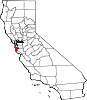
Nickname(s): South City; The Industrial City Location in San Mateo County and the state of California
Coordinates: 37°39′22″N 122°25′32″W / 37.65611°N 122.42556°WCoordinates: 37°39′22″N 122°25′32″W / 37.65611°N 122.42556°W Country  United States
State  California
County San Mateo Incorporated September 3, 1908 Government – Mayor Kevin Mullin – Vice Mayor Richard Garbarino – City Manager Barry Nagel[1] – Councilmembers Mark N. Addiego
Karyl Matsumoto
Pedro GonzalezArea[2] – Total 30.158 sq mi (78.109 km2) – Land 9.141 sq mi (23.674 km2) – Water 21.017 sq mi (54.435 km2) 69.69% Elevation 13 ft (4 m) Population (2010) – Total 63,632 – Density 6,961.1/sq mi (2,687.7/km2) United States Census Bureau Time zone PST (UTC-8) – Summer (DST) PDT (UTC-7) ZIP codes 94080, 94083, 94099 Area code(s) 650 FIPS code 06-73262 GNIS feature ID 0277618 Website http://www.ssf.net South San Francisco is a city in San Mateo County, California, United States, located on the San Francisco Peninsula in the San Francisco Bay Area. The population was 63,632 at the 2010 census.
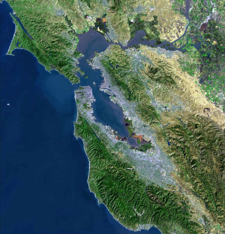
South San Francisco lies north of San Bruno and San Francisco International Airport in a small valley south of Daly City, Colma, Brisbane, and San Bruno Mountain, east of Pacifica and the hills of the Coast Range, and west of the waters of San Francisco Bay. Most of the valley faces San Francisco Bay, affording bay views from higher levels.
South San Francisco has mild winters and dry cool summers. The hills to the west shield the city from much of the fog that prevails in neighboring areas.
Population has tripled since World War II with the opening of such subdivisions as Buri Buri, Winston Manor and Westborough on the slopes west of El Camino. It has grown from 4,411 in 1920 to 61,824 in 2006.
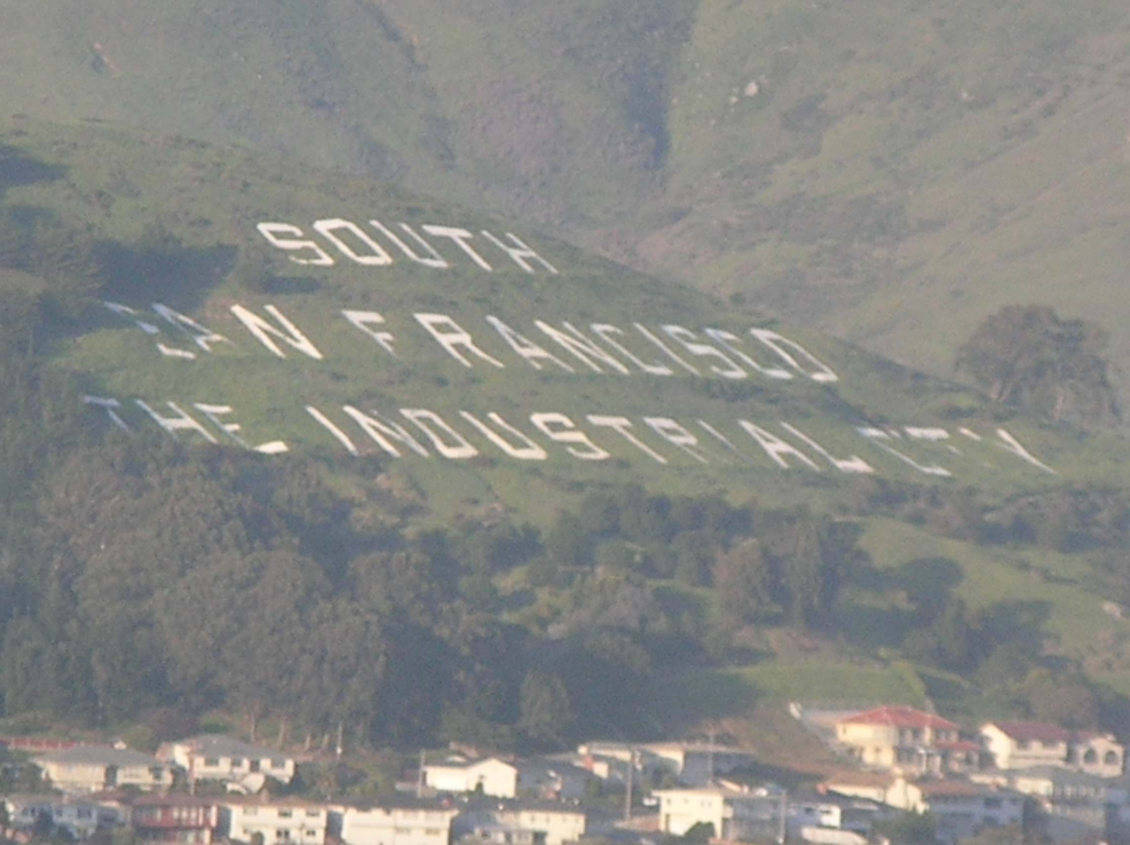
Sign Hill, which rises to the north of the city bears large white letters that proclaim: "South San Francisco, The Industrial City," which refers mainly to the flat land east of the Bayshore Freeway (US 101). Locals often refer to the town as "South City," in much the same way that San Francisco is called "The City." People unfamiliar with the area often mistake "South San Francisco" as the southern part of the city of San Francisco. In fact, the city of South San Francisco is not even contiguous with the city of San Francisco, due to the city of Brisbane being between it and San Francisco itself.
Contents
Transportation
South San Francisco is adjacent to the San Francisco International Airport (SFO). A BART station, located directly adjacent to El Camino High School and Solaire Transit Village, provides rapid transit service to SFO, the city of San Francisco, and the East Bay. BART supplements the older Caltrain service to San Francisco and San Jose. Caltrain's station is adjacent to downtown on Grand Ave.
The city is served by two major north-south freeways, U.S. Route 101 (the Bayshore Freeway), along the San Francisco Bay, and Interstate 280, along the hills of the Santa Cruz Mountains.
Education
 South San Francisco High School, also known as South City High
South San Francisco is part of the South San Francisco Unified School District, which also serves portions of the neighboring cities of Daly City and San Bruno. The city is home to two public high schools: El Camino High School and South San Francisco High School, which share a cross-town rivalry.[citation needed] The city also has three public middle schools: Parkway Heights, Westborough, and Alta Loma. These public high and middle schools, as well as a number of public elementary schools, and an adult school, South San Francisco Adult Education, are part of the South San Francisco Unified School District.
Several parochial schools are also established in the city: All Souls School, Mater Dolorosa School (recently closed), and St. Veronica's School.
The city is served by the Peninsula Library System.
Fire stations
South San Francisco currently has five fire stations. Station 61 is home to Engine 61, Rescue 61, Battalion 17,and a BLS ambulance. Station 62 is home to Quint 62 and was home to a reserve quint but was, because of old age, it was donated to Atotonilco,Mexico, a sister city. Station 63 is home to Engine and Rescue 63. It's nickname is "The Bunker". Station 64 is home to Engine 64 as well as a reserve ambulance. Station 65 is home to E65 and USAR 165. Quint 65 used to be based here. Rescue Boat 62 is located at Oyster Point Marina and can be staffed by Q62 personnel if needed.
Neighborhoods
The city's small downtown and several aging residential subdivisions, such as Mayfair Village, Sunshine Gardens, Avalon Park, Winston Manor, and Rancho Buri Buri, are located west of Highway 101, while the area east of Highway 101 is dominated by industrial complexes interspersed with modern office parks, particularly near the Oyster Point Marina on San Francisco Bay. The extreme western portions of the city near Interstate 280 sit along a hillside and offer views of San Francisco Bay. This area is known to local residents as Westborough. The southern part of the city, closest to the airport, is home to a large number of car repair shops, airport parking lots, and airport hotels.
Grand Avenue, from Chestnut to Airport, is considered downtown South San Francisco, with various small shops and restaurants. Grand Avenue is host to a plethora of stores, one of which is Bronstein Music, a well-known local music store that has been around for decades. City Hall is located on Grand Avenue, which, to the residents of South City, is known simply as "Grand." Grand also runs perpendicular with one of the city's other well-known streets, Linden, which connects San Bruno to Highway 101. Chestnut Avenue connects Hillside, the northern bordering street at the foot of San Bruno Mountain, to Westborough Blvd, and subsequently to one of the neighborhoods known as Westborough.
South San Francisco Consists of the following Neighborhoods:
- Avalon Park
- Avalon Pines
- Brentwood
- Buri Buri
- Cypress
- Francisco Terrace
- Mayfair Village
- Paradise Valley
- Parkhaven
- Parkway
- Pecks Lot
- Peninsula Pines
- Serra Highlands
- Southwood
- Sunshine Gardens
- Susie Way
- The East Side
- West Winston Manor
- Westborough
- West Park
- Winston Manor
Paradise Valley is so named because it resides in between Sign Hill and San Bruno Mountain. Students mostly from Westborough and Buri Buri attend El Camino High School. The majority of Brentwood and Paradise Valley inhabitants attend South San Francisco High School, as well as the East Side inhabitants. The same inhabitants are also so-divided among Westborough Middle School, Alta Loma Middle School and Parkway Heights Middle School respectively.
Points of interest and recreation
 The "South San Francisco The Industrial City" sign
South San Francisco is not known as a tourist destination, but a key landmark of the city is visible to anyone who travels along the San Francisco Peninsula or travels through the nearby San Francisco International Airport. Sign Hill, near San Bruno Mountain State Park has huge letters on its mountainside [2] which read: "SOUTH SAN FRANCISCO THE INDUSTRIAL CITY." The letters are made of concrete and sit flush with the hillside (in contrast to the raised steel letters of the Hollywood Sign in Los Angeles). A discontinued tradition involved painting the "c"s on the sign blue and the "s"s red in significance of the annual "Big Game" played by Stanford University and the University of California, Berkeley. However, a new tradition has replaced it. Every year South San Francisco High School plays their rival El Camino High School (South San Francisco) (both schools are located in South San Francisco) in the "Bell Game," the last football game of the regular season for both teams. It is said that students from South City paint the "SC" in blue before the start of the Bell Game and students from El Camino paint the "EC" red. The "SF" from South and Francisco were painted orange after the San Francisco Giants won the 2010 World Series. On the top of Sign Hill, a tall pole with electric lights serves as an electric Christmas tree, which is typically lit from the day after Thanksgiving until January 6. The "tree" is visible for many miles at night. In 2008, that same electric pole was modified to hold a vertical number 100 to celebrate South San Francisco's 100th year as an incorporated city.
South San Francisco has a number of parks, the largest of which is Orange Memorial Park. This park has softball fields, soccer fields, picnic grounds, play areas, tennis courts, basketball courts, bocce ball, an indoor swimming pool, and a newly created skate park. It also hosts a farmers market during the summer months and the annual South San Francisco "Day in the Park" in September. The South San Francisco Public Library has served the city since 1917. The city also has a marina along the shore of San Francisco Bay, named Oyster Point.
A unique opportunity was created when BART expanded down the Peninsula to create a "linear park" on the swath of unimproved land on top of the tube. Running from Colma to Millbrae, South San Francisco's portion is three miles long, running through the center of town from the South San Francisco BART Station to the San Bruno BART Station. The Class I bicycle and pedestrian trail is a 10" wide asphalt pathway with 2' decomposed granite shoulders, irrigated for low maintenance landscaping, with safety lighting, signalized intersections where the trail crosses Spruce and Chestnut Avenues, and in-ground flashing lights at Orange Avenue. Also, a dog park is located adjacent from Orange Park along the pathway. The new park is called Centennial Way to commemorate the City's 100 year birthday in 2008.
The South San Francisco Farmers Market is at Orange Memorial Park from May through October, 9am to 1pm. The market offers only California-grown products sold directly to consumers by the farmers that grew, nurtured and harvested the crops
Every Holiday season, the Parkway Estates, a group of high-income houses built decades ago, decorate their houses with Christmas lights and Yard decorations. This display is always open to the public and sees hundreds of visitors every holiday season. It is one of the well known holiday attractions during the season. A smaller, littler-known area that does this too is Lilac Lane, which does not draw as much attention.
Bertolucci's is the name of a local Italian Restaurant that has also been around almost since the birth of the city. It is a widely, internationally known restaurant that thrived during the 60s/70s. It is located in close proximity to downtown South San Francisco and is easily seen from highway 101.
South San Francisco has one bowling alley known as Brentwood Bowl due to its proximity to the Brentwood Neighborhood on El Camino Real. The city is also home to the private California Golf & Country Club, next to its public library and bounded by Ponderosa Road.
South San Francisco has many walkways and bike trails that run adjacent to the San Francisco Bay, from where runners are able to view San Francisco International Airport operations. South San Francisco is home to many hotels as well, since it is the closest city to San Francisco that is actually directly next to SFO.
Economy
 Headquarters of See's Candies on El Camino Real, South San Francisco
Much of what is now South San Francisco was initially agricultural land, and was originally known as Baden. Small pockets of farmland still exist near San Bruno Mountain, but these lands are disappearing quickly because of the demand for housing and retail development. Acres of Orchids, founded by the Rod McLellan Company in the late 1920s, was one such victim of housing development. Once one of the largest facilities in the United States producing orchids and gardenias, the nursery closed in 1998.[3] A new housing tract now sits upon the land formerly occupied by Acres of Orchids greenhouses, off El Camino near Hickey.
 A Genentech-sponsored sign declaring South San Francisco to be the "Birthplace of Biotechnology."
The flat land east of Bayshore Freeway (US 101) is the R&D Campus of South San Francisco and carries on the tradition of the moniker on Sign Hill, "The Industrial City." South San Francisco's office parks and industrial zoning are favorable to meet needs of industry, and the property taxes levied from the extensive industrial park provide revenues for the city.[citation needed] South San Francisco is home to 1 Fortune 500 company, food wholesaler Core-Mark.
South San Francisco is home to Genentech, one of the world's largest biotech companies, as well as a satellite office of Amgen, the world's largest biotech firm. Many other biotech companies, such as Exelixis, have also started or moved to South San Francisco to be in proximity to the UCSF, Stanford University, and UC Berkeley; all are within a one hour's drive. A Genentech-sponsored sign declares South San Francisco as the "Birthplace of Biotechnology."[4]
The headquarters and factory of See's Candies is located in South San Francisco.[5] Air China operates an office in South San Francisco.[6]
Galoob had its headquarters in South San Francisco before Hasbro bought the company in 1998.[7] Hudson Soft USA, a subsidiary of Hudson Soft, had its headquarters in South San Francisco.[8]
Top employers
According to the City's 2010 Comprehensive Annual Financial Report,[9] the top employers in the city are:
# Employer # of Employees 1 Genentech 8,552 2 Amgen 751 3 Costco 403 4 Royal Laundry 307 5 Bimbo Bakeries USA 300 6 Guckenheimer 200 7 Columbus Salame 191 8 Matagrano 183 9 Actelion US 176 10 Nippon Express USA 174 Geography
South San Francisco is located at 37°39′22″N 122°25′32″W / 37.65611°N 122.42556°W (37.655983, -122.425525)[10].
According to the United States Census Bureau, the city has a total area of 30.2 square miles (78 km2), of which, 9.1 square miles (24 km2) of it is land and 21.0 square miles (54 km2) of it (69.69%) is water.
Demographics
2010
The 2010 United States Census[11] reported that South San Francisco had a population of 63,632. The population density was 2,109.9 people per square mile (814.7/km²). The racial makeup of South San Francisco was 23,760 (37.3%) White, 1,625 (2.6%) African American, 395 (0.6%) Native American, 23,293 (36.6%) Asian, 1,111 (1.7%) Pacific Islander, 9,598 (15.1%) from other races, and 3,850 (6.1%) from two or more races. Hispanic or Latino of any race were 21,645 persons (34.0%). Among the Hispanic population, 13,194 (20.7%) are Mexican, 571 (0.9%) are Puerto Rican, 92 (0.1%) are Cuban, and 7,788 (12.2%) are other Hispanic or Latino.
The Census reported that 63,053 people (99.1% of the population) lived in households, 528 (0.8%) lived in non-institutionalized group quarters, and 51 (0.1%) were institutionalized.
There were 20,938 households, out of which 7,588 (36.2%) had children under the age of 18 living in them, 11,165 (53.3%) were opposite-sex married couples living together, 2,897 (13.8%) had a female householder with no husband present, 1,268 (6.1%) had a male householder with no wife present. There were 1,083 (5.2%) unmarried opposite-sex partnerships, and 187 (0.9%) same-sex married couples or partnerships. 4,299 households (20.5%) were made up of individuals and 1,857 (8.9%) had someone living alone who was 65 years of age or older. The average household size was 3.01. There were 15,330 families (73.2% of all households); the average family size was 3.45.
The population was spread out with 13,787 people (21.7%) under the age of 18, 5,668 people (8.9%) aged 18 to 24, 18,645 people (29.3%) aged 25 to 44, 17,203 people (27.0%) aged 45 to 64, and 8,329 people (13.1%) who were 65 years of age or older. The median age was 38.1 years. For every 100 females there were 97.6 males. For every 100 females age 18 and over, there were 95.7 males.
There were 21,814 housing units at an average density of 723.3 per square mile (279.3/km²), of which 12,614 (60.2%) were owner-occupied, and 8,324 (39.8%) were occupied by renters. The homeowner vacancy rate was 1.3%; the rental vacancy rate was 4.0%. 37,802 people (59.4% of the population) lived in owner-occupied housing units and 25,251 people (39.7%) lived in rental housing units.
2000
As of the census[12] of 2008, there were 62,502 people, 20,118 households, and 15,431 families residing in the city. The population density was 7,712.8 people per square mile (3,591.9/km²). There were 20,870 housing units at an average density of 3,232.5 per square mile (962.0/km²).
There were 20,118 households out of which 39.2% had children under the age of 18 living with them, 51.8% were married couples living together, 11.2% had a female householder with no husband present, and 28.5% were non-families. 21.9% of all households were made up of individuals and 8.0% had someone living alone who was 65 years of age or older. The average household size was 4.05 and the average family size was 4.51.
In the city the population was spread out with 25.2% under the age of 18, 11.2% from 18 to 24, 33.0% from 25 to 44, 22.0% from 45 to 64, and 11.6% who were 65 years of age or older. The median age was 33 years. For every 100 females there were 99.3 males. For every 100 females age 18 and over, there were 91.5 males.
The median income for a household in the city was $60,764, and the median income for a family was $65,598. Males had a median income of $41,742 versus $35,453 for females. The per capita income for the city was $25,562. About 5.5% of families and 6.2% of the population were below the poverty line, including 9.1% of those under age 18 and 5.7% of those age 65 or over.
South San Francisco is a middle class and working class city. However, that image is quickly changing as many luxury homes have been built, particularly at the foot of the mountain that divides Brisbane and South San Francisco, in the area in recent years to take advantage of the city's close proximity to downtown San Francisco, the bio-tech industry, and the peninsula. There are also developments of luxury condominiums in the Westborough district and on El Camino Real near the South San Francisco BART station.
The most commonly spoken language at home was English 43.13%, followed by Spanish 28.36%, Tagalog 11.48%, Chinese 3.4%, Hindi 1.5%, Arabic 1.59%, Cantonese 1.53%, Italian 1.47%, Vietnamese 0.67%, Russian 0.56%, Korean and Japanese 0.6% respectively, other languages were spoken by less than half of one percent of the population.[13]
Politics
In the state legislature South San Francisco is located in the 8th Senate District, represented by Democrat Leland Yee, and in the 19th Assembly District, represented by Democrat Jerry Hill. Federally, South San Francisco is located in California's 12th congressional district, which has a Cook PVI of D +22[14] and is currently held by Democrat Jackie Speier.
Sister Cities[15]
 Atotonilco, Mexico
 Kishiwada, Japan
 Lucca, Italy
 Pasig City, Philippines
References
- ^ South San Francisco City Manager, South San Francisco city website, access date May 31, 2008
- ^ U.S. Census
- ^ Matters Historical: Dominating county's nursery business
- ^ Perrigan, Dana."Proud of past, South San Francisco looks ahead","The San Francisco Chronicle", February 15, 2009, accessed July 26, 2011.
- ^ "About Us." See's Candies. Retrieved on January 18, 2009.
- ^ "International Offices." Air China. Retrieved on January 18, 2009.
- ^ Fost, Dan. "Hasbro Adds Galoob to Its Toy Chest." San Francisco Chronicle. Tuesday September 29, 1998. Retrieved on April 25, 2010.
- ^ "KIDS' GIFTS: A NINTENDO NIGHTMARE BAD-BOY VIDEO GAMES HAVE PARENTS, MAKERS TALKING MODERATION." San Jose Mercury News. December 20, 1992. 1A Front. Retrieved on July 12, 2010. "Hudson Soft USA Inc. of South San Francisco..."
- ^ City of South San Francisco Comprehensive Annual Financial Report, Year Ended June 30, 2010 Retrieved 2010-09-24
- ^ "US Gazetteer files: 2010, 2000, and 1990". United States Census Bureau. 2011-02-12. http://www.census.gov/geo/www/gazetteer/gazette.html. Retrieved 2011-04-23.
- ^ All data are derived from the United States Census Bureau reports from the 2010 United States Census, and are accessible on-line here. The data on unmarried partnerships and same-sex married couples are from the Census report DEC_10_SF1_PCT15. All other housing and population data are from Census report DEC_10_DP_DPDP1. Both reports are viewable online or downloadable in a zip file containing a comma-delimited data file. The area data, from which densities are calculated, are available on-line here. Percentage totals may not add to 100% due to rounding. The Census Bureau defines families as a household containing one or more people related to the householder by birth, opposite-sex marriage, or adoption. People living in group quarters are tabulated by the Census Bureau as neither owners nor renters. For further details, see the text files accompanying the data files containing the Census reports mentioned above.
- ^ "American FactFinder". United States Census Bureau. http://factfinder.census.gov. Retrieved 2008-01-31.
- ^ MLA, South San Francisco entry, retrieved November 13, 2007
- ^ "Will Gerrymandered Districts Stem the Wave of Voter Unrest?". Campaign Legal Center Blog. http://www.clcblog.org/blog_item-85.html. Retrieved 2008-02-10.
- ^ [1]
External links
- Official website
- Official Guide to SSF from the chamber of commerce
- City data guide to SSF for relocation
Municipalities and communities of San Mateo County, California Cities and towns Atherton | Belmont | Brisbane | Burlingame | Colma | Daly City | East Palo Alto | Foster City | Half Moon Bay | Hillsborough | Menlo Park | Millbrae | Pacifica | Portola Valley | Redwood City | San Bruno | San Carlos | San Mateo | South San Francisco | Woodside
CDPs Unincorporated
communitiesGhost towns U.S. National Register of Historic Places Topics Lists by states Alabama • Alaska • Arizona • Arkansas • California • Colorado • Connecticut • Delaware • Florida • Georgia • Hawaii • Idaho • Illinois • Indiana • Iowa • Kansas • Kentucky • Louisiana • Maine • Maryland • Massachusetts • Michigan • Minnesota • Mississippi • Missouri • Montana • Nebraska • Nevada • New Hampshire • New Jersey • New Mexico • New York • North Carolina • North Dakota • Ohio • Oklahoma • Oregon • Pennsylvania • Rhode Island • South Carolina • South Dakota • Tennessee • Texas • Utah • Vermont • Virginia • Washington • West Virginia • Wisconsin • WyomingLists by territories Lists by associated states Other Categories:- Buildings and structures on the National Register of Historic Places in California
- South San Francisco, California
- Incorporated cities and towns in California
- Cities in San Mateo County, California
- Cities in the San Francisco Bay Area
- Populated places in the United States with Asian plurality populations


Wikimedia Foundation. 2010.