East Tamworth, New South Wales
- East Tamworth, New South Wales
Infobox Australian Place | type = suburb
name = East Tamworth
city = Tamworth
state = nsw
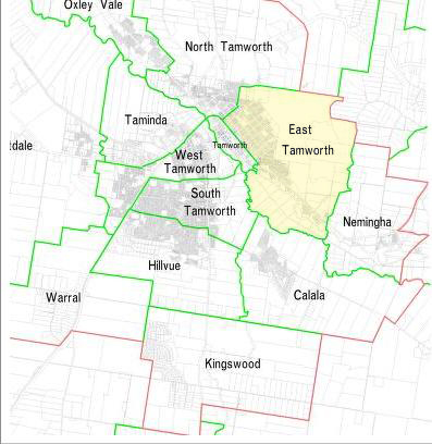
caption = East Tamworth in yellow
lga = Tamworth Regional Council
postcode = 2340
est =
pop = 2001 estimate: 2,621 [Tamworth Community Profile 2001, http://www.tamworth.nsw.gov.au/asp/index.asp?pgid=34162]
area =
propval =
stategov = Tamworth,
fedgov = New England
near-nw = North Tamworth
near-n =
near-ne =
near-w =
near-e = Nemingha
near-sw = Tamworth Central Business District
near-s =
near-se =
dist1 =
location1=
East Tamworth is a suburb of Tamworth, New South Wales, Australia, in the city's east. It is located between the suburbs of North Tamworth, Tamworth CBD and the satellite suburb of Nemingha. East Tamworth is one of the oldest settled areas of Tamworth, and therefore is known for its wide streets and historical buildings and homes. Many of these historical buildings are the highest valued properties in Tamworth. East Tamworth is home to ANZAC Park, Tamworth Public School and Calrossy Anglican School for Girls.
ocio-economic status
East Tamworth is considered to be the highest socio-economic area of Tamworth because of property values in the suburb.
chools
*Tamworth Public School
*Calrossy Anglican School for Girls
References
Wikimedia Foundation.
2010.
Look at other dictionaries:
Tamworth, New South Wales — Infobox Australian Place | type = city name = Tamworth state = nsw caption = Aerial view of Tamworth lga = Tamworth Regional Council county = Inglis postcode = 2340 pop = 42,499 (2006) poprank = 34th est = 1818 (explored) 1850 (established) 1946… … Wikipedia
North Tamworth, New South Wales — North Tamworth Tamworth, New South Wales North Tamworth Sunset Population … Wikipedia
Kingswood (Tamworth), New South Wales — Infobox Australian Place | type = suburb name = Kingswood city = Tamworth state = nsw caption = lga = Tamworth Regional Council postcode = 2340 est = pop = area = propval = stategov = Tamworth, fedgov = New England near nw = near n = Hillvue near … Wikipedia
Coledale (Tamworth), New South Wales — Infobox Australian Place | type = suburb name = Coledale city = Tamworth state = nsw caption = lga = Tamworth Regional Council postcode = 2340 est = pop = 2001 estimate: 3,154 [Tamworth Community Profile 2001,… … Wikipedia
New England (New South Wales) — New England New South Wales Mount Duval in New England Population … Wikipedia
Tamworth Central Business District, New South Wales — Infobox Australian Place | type = suburb name = Tamworth Central Business District city = Tamworth state = nsw caption = Peel St lga = Tamworth Regional Council postcode = 2340 est = pop = area = propval = stategov = Tamworth, fedgov = New… … Wikipedia
New South Wales state election, 2011 — 2007 ← 26 March 2011 → 2015 … Wikipedia
Oxley Vale, New South Wales — Oxley Vale Tamworth, New South Wales Population: 2001 estimate: 2,891[1] Postcode: 2340 … Wikipedia
Daruka Estate, New South Wales — Infobox Australian Place | type = suburb name = Daruka Estate city = Tamworth state = nsw caption = lga = Tamworth Regional Council postcode = 2340 est = pop = 2001 estimate: 2,000 [Tamworth Community Profile 2001,… … Wikipedia
New South Wales — NSW redirects here. For the historical region of Canada, see New Britain (Canada). For other uses, see NSW (disambiguation). Coordinates: 32°0′S 147°0′E / 32°S 147°E … Wikipedia