- Los Alamos, California
Infobox Settlement
official_name = Los Alamos, California
other_name =
native_name =
nickname =
settlement_type = CDP
motto =
imagesize =
image_caption =
flag_size =
image_
seal_size =
image_shield =
shield_size =
image_blank_emblem =
blank_emblem_type =
blank_emblem_size =
imagesize =
image_caption =
flag_size =
image_
seal_size =
image_shield =
shield_size =
image_blank_emblem =
blank_emblem_type =
blank_emblem_size =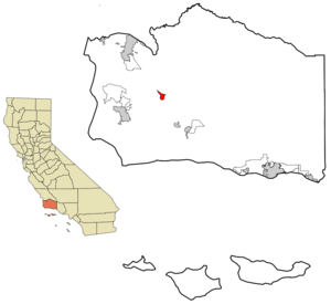
mapsize = 250x200px
map_caption = Location in Santa Barbara County and the state ofCalifornia
mapsize1 =
map_caption1 =
image_dot_
dot_mapsize =
dot_map_caption =
dot_x =
dot_y =
pushpin_
pushpin_label_position =
pushpin_map_caption =
pushpin_mapsize =
subdivision_type = Country
subdivision_name =United States
subdivision_type1 = State
subdivision_name1 =California
subdivision_type2 = County
subdivision_name2 = Santa Barbara
subdivision_type3 =
subdivision_name3 =
subdivision_type4 =
subdivision_name4 =
government_footnotes =
government_type =
leader_title = N/A
leader_name =
leader_title1 =
leader_title1 = Senate
leader_name1 =Tom McClintock (R)
leader_title2 = Assembly
leader_name2 =Sam Blakeslee (R)
leader_title3 = U. S. Congress
leader_name3 =Elton Gallegly (R)
leader_title4 =
leader_name4 =
established_title =
established_date =
established_title2 =
established_date2 =
established_title3 =
established_date3 =
area_magnitude =
unit_pref =
area_footnotes =
area_total_km2 = 6.1
area_land_km2 = 6.1
area_water_km2 = 0
area_total_sq_mi = 2.4
area_land_sq_mi = 2.4
area_water_sq_mi = 0
area_water_percent =
area_urban_km2 =
area_urban_sq_mi =
area_metro_km2 =
area_metro_sq_mi =
area_blank1_title =
area_blank1_km2 =
area_blank1_sq_mi =
population_as_of = 2000
population_footnotes =
population_note =
population_total = 1372
population_density_km2 = 224.9
population_density_sq_mi = 571.7
population_metro =
population_density_metro_km2 =
population_density_metro_sq_mi =
population_urban =
population_density_urban_km2 =
population_density_urban_sq_mi =
population_blank1_title =
population_blank1 =
population_density_blank1_km2 =
population_density_blank1_sq_mi =
timezone = PST
utc_offset = -8
timezone_DST = PDT
utc_offset_DST = -7
latd = 34 |latm = 44 |lats = 31 |latNS = N
longd = 120 |longm = 16 |longs = 31 |longEW = W
elevation_footnotes =
elevation_m = 174
elevation_ft = 571
postal_code_type =ZIP code
postal_code = 93440
area_code = 805
blank_name = FIPS code
blank_info = 06-43252
blank1_name = GNIS feature ID
blank1_info = 0245130
website =
footnotes = "For other places named Los Alamos, seeLos Alamos, New Mexico andLos Alamos National Laboratory ."Los Alamos is a
census-designated place (CDP) in Santa Barbara County,California ,United States . Although located in the Los Alamos Valley, the town of Los Alamos is usually considered to be a part of the Santa Ynez Valley community. The population was 1,372 at the 2000 census.Geography
Los Alamos is located at coor dms|34|44|31|N|120|16|31|W|city (34.741984, -120.275397)GR|1.
According to the
United States Census Bureau , the CDP has a total area of 2.3 square miles (6.1 km²), all of it land.Los Alamos is located near the
Santa Ynez Valley , alongU.S. Route 101 . It is a small, unincorporated town surrounded primarily with ranches, vegetable farms (broccoli ,lettuce , and strawberries), and wine grapevineyards .Los Alamos is relatively isolated. It is about convert|10|mi|km to
Buellton, California andLos Olivos, California to the Southeast, andSanta Maria, California to the Northwest along Highway 101.Lompoc, California andVandenberg Air Force Base are to the Southwest.Demographics
As of the
census GR|2 of 2000, there were 1,372 people, 471 households, and 349 families residing in the CDP. Thepopulation density was 582.8 people per square mile (225.4/km²). There were 488 housing units at an average density of 207.3/sq mi (80.2/km²). The racial makeup of the CDP was 76.90% White, 0.22% African American, 1.82% Native American, 0.73% Asian, 0.51% Pacific Islander, 15.09% from other races, and 4.74% from two or more races. Hispanic or Latino of any race were 34.69% of the population.There were 471 households out of which 44.2% had children under the age of 18 living with them, 58.0% were married couples living together, 11.3% had a female householder with no husband present, and 25.9% were non-families. 20.4% of all households were made up of individuals and 6.8% had someone living alone who was 65 years of age or older. The average household size was 2.91 and the average family size was 3.36.
In the CDP the population was spread out with 31.9% under the age of 18, 7.7% from 18 to 24, 34.2% from 25 to 44, 19.3% from 45 to 64, and 7.0% who were 65 years of age or older. The median age was 34 years. For every 100 females there were 102.7 males. For every 100 females age 18 and over, there were 96.0 males.
The median income for a household in the CDP was $47,321, and the median income for a family was $49,125. Males had a median income of $32,206 versus $30,714 for females. The
per capita income for the CDP was $18,013. About 10.3% of families and 13.1% of the population were below thepoverty line , including 18.2% of those under age 18 and 2.2% of those age 65 or over.Community
U.S. Route 101 used to pass right through town on Bell Street before the highway was realigned in the 1950s. This realignment was both a blessing and a curse for Los Alamos. There were a number of deaths due to cars versus pedestrians in Los Alamos when Highway 101 went through town. However, when the highway was moved just North of town, there was far less traffic to patronize the local businesses, and Los Alamos declined economically.At the end of September of each year, Los Alamos hosts a town festival called "Old Days." Food and craft vendors line Bell Street and there is music and other forms of entertainment. Old Days has been held for more than 55 years.
The
Los Alamos Ranch House is anadobe building dating from the Mexican era, and is aNational Historic Landmark .External links
Wikimedia Foundation. 2010.