- Orcutt, California
-
Orcutt — census-designated place — Nickname(s): "O" Town Location in Santa Barbara County and the state of California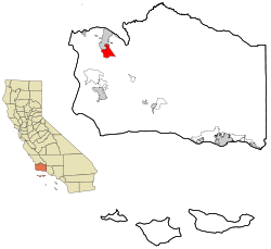
Coordinates: 34°52′28″N 120°25′41″W / 34.87444°N 120.42806°WCoordinates: 34°52′28″N 120°25′41″W / 34.87444°N 120.42806°W Country  United States
State  California
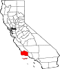
County Santa Barbara Government – N/A – Senate Abel Maldonado (R)
Tom McClintock (R)– Assembly Sam Blakeslee (R) – U. S. Congress Elton Gallegly (R) Area[1] – Total 11.129 sq mi (28.825 km2) – Land 11.124 sq mi (28.811 km2) – Water 0.005 sq mi (0.014 km2) 0.05% Elevation 358 ft (109 m) Population (2010) – Total 35,262 – Density 3,168.5/sq mi (1,223.3/km2) Time zone PST (UTC-8) – Summer (DST) PDT (UTC-7) ZIP codes 93455, 93457 Area code(s) 805 FIPS code 06-54120 GNIS feature ID 1661153 Orcutt is an unincorporated township located in the Santa Maria Valley of California, and a census-designated place; it is in Santa Barbara County, California, United States. Orcutt is named for William W. Orcutt, the manager of the Geological, Land and Engineering Departments of the Union Oil Company. Known as the “Dean of Petroleum Geologists" Orcutt is credited with discovering fossilized prehistoric animal bones preserved in pools of asphalt on the Hancock Ranch. These would be the first of many fossils excavated from the La Brea Tar Pits. In commemoration of Orcutt’s initial discovery, paleontologists named the La Brea Coyote in W.W. Orcutt’s honor, Canis Orcutti.[2]
The population of Orcutt was 35,262 at the 2010 census, up from 28,830 at the 2000 census.
Contents
Geography
Orcutt is located at 34°52′28″N 120°25′41″W / 34.87444°N 120.42806°W (34.874550, -120.428067).[3]
According to the United States Census Bureau, the CDP has a total area of 11.1 square miles (29 km2), 99.95% of it land and 0.05% of it water.
Orcutt, originally sited along a railroad siding of the Pacific Coast Railroad as a townsite for oil field workers,[4] is now primarily a bedroom community/suburb of Santa Maria, which is adjacent to the north. Located between Ca. State 135 on the East and South, Ca Hwy 1 on the West, the Northern boundry is south side of the Foxenwood section. In 2005 it was one of the fastest-growing places in Santa Barbara County.
Demographics
2010
The 2010 United States Census[5] reported that Orcutt had a population of 35,262. The population density was 2,597.2 people per square mile (1,002.8/km²). The racial makeup of Orcutt was 28,677 (88.9%) White, 394 (1.4%) African American, 347 (1.2%) Native American, 1,129 (3.9%) Asian, 59 (0.2%) Pacific Islander, 2,006 (6.9%) from other races, and 1,293 (4.5%) from two or more races. Hispanic or Latino of any race were 6,870 persons (16.8%).
The Census reported that 28,792 people (99.6% of the population) lived in households, 86 (0.3%) lived in non-institutionalized group quarters, and 27 (0.1%) were institutionalized.
There were 10,631 households, out of which 3,638 (34.2%) had children under the age of 18 living in them, 6,272 (59.0%) were opposite-sex married couples living together, 1,130 (10.6%) had a female householder with no husband present, 481 (4.5%) had a male householder with no wife present. There were 417 (3.9%) unmarried opposite-sex partnerships, and 57 (0.5%) same-sex married couples or partnerships. 2,279 households (21.4%) were made up of individuals and 1,300 (12.2%) had someone living alone who was 65 years of age or older. The average household size was 2.71. There were 7,883 families (74.2% of all households); the average family size was 3.14.
The population was spread out with 7,034 people (24.3%) under the age of 18, 2,295 people (7.9%) aged 18 to 24, 6,157 people (21.3%) aged 25 to 44, 8,327 people (28.8%) aged 45 to 64, and 5,092 people (17.6%) who were 65 years of age or older. The median age was 42.3 years. For every 100 females there were 96.1 males. For every 100 females age 18 and over, there were 92.7 males.
There were 11,133 housing units at an average density of 1,000.3 per square mile (386.2/km²), of which 8,304 (78.1%) were owner-occupied, and 2,327 (21.9%) were occupied by renters. The homeowner vacancy rate was 1.9%; the rental vacancy rate was 4.5%. 22,043 people (76.3% of the population) lived in owner-occupied housing units and 6,749 people (23.3%) lived in rental housing units.
2000
As of the census[6] of 2000, there were 28,830 people, 10,420 households, and 8,023 families residing in the CDP. The population density was 2,551.0 people per square mile (985.1/km²). There were 10,640 housing units at an average density of 941.5 per square mile (363.6/km²). The racial makeup of the CDP was 86.68% White, 1.40% African American, 0.92% Native American, 3.20% Asian, 0.08% Pacific Islander, 3.91% from other races, and 3.81% from two or more races. Hispanic or Latino of any race were 14.45% of the population.
There were 10,420 households out of which 35.1% had children under the age of 18 living with them, 65.0% were married couples living together, 8.6% had a female householder with no husband present, and 23.0% were non-families. 19.1% of all households were made up of individuals and 10.4% had someone living alone who was 65 years of age or older. The average household size was 2.74 and the average family size was 3.14.
In the CDP the population was spread out with 27.0% under the age of 18, 6.1% from 18 to 24, 25.2% from 25 to 44, 24.0% from 45 to 64, and 17.7% who were 65 years of age or older. The median age was 40 years. For every 100 females there were 95.0 males. For every 100 females age 18 and over, there were 90.4 males.
The median income for a household in the CDP was $53,251, and the median income for a family was $59,865. Males had a median income of $49,035 versus $30,700 for females. The per capita income for the CDP was $23,373. About 2.6% of families and 4.6% of the population were below the poverty line, including 4.7% of those under age 18 and 5.3% of those age 65 or over.
References
- ^ U.S. Census
- ^ City of Los Angeles Department of Recreation and Park History Brochure
- ^ "US Gazetteer files: 2010, 2000, and 1990". United States Census Bureau. 2011-02-12. http://www.census.gov/geo/www/gazetteer/gazette.html. Retrieved 2011-04-23.
- ^ Santa Barbara Independent, Michael Redmon, Dec. 21, 2009
- ^ All data are derived from the United States Census Bureau reports from the 2010 United States Census, and are accessible on-line here. The data on unmarried partnerships and same-sex married couples are from the Census report DEC_10_SF1_PCT15. All other housing and population data are from Census report DEC_10_DP_DPDP1. Both reports are viewable online or downloadable in a zip file containing a comma-delimited data file. The area data, from which densities are calculated, are available on-line here. Percentage totals may not add to 100% due to rounding. The Census Bureau defines families as a household containing one or more people related to the householder by birth, opposite-sex marriage, or adoption. People living in group quarters are tabulated by the Census Bureau as neither owners nor renters. For further details, see the text files accompanying the data files containing the Census reports mentioned above.
- ^ "American FactFinder". United States Census Bureau. http://factfinder.census.gov. Retrieved 2008-01-31.
Municipalities and communities of Santa Barbara County, California Cities Buellton | Carpinteria | Goleta | Guadalupe | Lompoc | Santa Barbara | Santa Maria | Solvang
CDPs Ballard | Casmalia | Cuyama | Garey | Isla Vista | Los Alamos | Los Olivos | Mission Canyon | Mission Hills | Montecito | New Cuyama | Orcutt | Santa Ynez | Sisquoc | Summerland | Toro Canyon | Vandenberg AFB | Vandenberg Village
Unincorporated
communitiesGaviota | Hope Ranch | Las Cruces | Painted Cave | Ventucopa
Ghost town Santa Rita
Categories:- Census-designated places in Santa Barbara County, California


Wikimedia Foundation. 2010.