- Mount Shasta, California
-
This article is about the city. For the community in Shasta County, California, see Shasta, California. For the mountain, see Mount Shasta.
City of Mount Shasta — City — Location in Siskiyou County and the state of California
Coordinates: 41°18′52″N 122°18′41″W / 41.31444°N 122.31139°WCoordinates: 41°18′52″N 122°18′41″W / 41.31444°N 122.31139°W Country  United States
State  California
County Siskiyou Area[1] – Total 3.770 sq mi (9.764 km2) – Land 3.766 sq mi (9.754 km2) – Water 0.004 sq mi (0.010 km2) 0.10% Elevation 3,606 ft (1,099 m) Population (2010) – Total 3,394 – Density 900.3/sq mi (347.6/km2) Time zone Pacific (PST) (UTC-8) – Summer (DST) PDT (UTC-7) ZIP code 96067 Area code(s) 530 FIPS code 06-49852 GNIS feature ID 0277559 Mount Shasta is a city in Siskiyou County, California, located at around 3,600 ft (1,100 m) on the flanks of Mount Shasta, a prominent northern California landmark. The city is less than 9 miles (14 km) southwest of the summit of its namesake volcano. As of the 2010 Census the city had a population of 3,394, down from 3,624 at the 2000 census.
Contents
Commerce and tourism
Located in the Shasta Cascade area of Northern California[2][3][4] Visitors use Mount Shasta as a base to engage in trout fishing in the nearby Sacramento,[5][6][7] McCloud[5][6] and Klamath[5] Rivers, or come to see and climb Mount Shasta, Castle Crags or the Trinity Alps.[2][3][4][8] Visitors also engage in nearby skiing[9] (both alpine and cross-country), or bike or hike to the waterfalls, streams and lakes in the area, including nearby Mossbrae Falls, Lake Siskiyou, Castle Lake and Shasta Lake.[2][3][4][8]
History
The site of present-day Mount Shasta City was within the range of the Okwanuchu tribe of Native Americans. During the 1820s, early Euro-American trappers and hunters first passed through the area, following the path of the Siskiyou Trail. The Siskiyou Trail was based on a network of ancient Native American footpaths connecting California and the Pacific Northwest. The discovery of gold at nearby Yreka, California in 1851, dramatically increased traffic along the Siskiyou Trail and through the site of present-day Mount Shasta. Pioneer Ross McCloud built one of the first lumber mills in the area, near the site of the present Sisson Museum. The completion of a stagecoach road between Yreka and Upper Soda Springs in the late 1850s led to the building of Sisson's Hotel, as a stop for weary travelers, and as a staging ground for adventuresome tourists intending to climb Mount Shasta.
 Mount Shasta from Mount Shasta City, California
The 1887 completion of the Central Pacific Railroad, built along the line of the Siskiyou Trail, brought a dramatic increase in tourism, lumbering, and population into Mount Shasta. This early development continued to focus on tourism and lumbering. The early 1900s saw the influx of a large number of Italian immigrants to Mount Shasta and neighboring towns, most of whom were employed in the timber industry.
The area where the town later grew up was known first as Strawberry Valley, and then as Berryvale. With the arrival of the railroad, the town was given the name Sisson, California, after prominent land owner Justin Sisson. The name was changed to Mount Shasta City in 1924.
Theosophist Guy Ballard claimed to have met Saint Germain while hiking on Mt. Shasta in 1930.
Geography
Mount Shasta is located at 41°18'52" North, 122°18'41" West (41.314542, -122.311510).[10] It is located along Interstate 5 south of Weed and north of Dunsmuir, California.
According to the United States Census Bureau, the city has a total area of 3.8 square miles (9.8 km2), of which, 3.8 square miles (9.8 km2) of it is land and 0.10% of it is covered by water.
The area hydrology consists of an unnamed stream in the south part of town which joins Big Springs Creek, which then flows south as Cold Creek to join the headwaters of the South Fork of the Sacramento River.[11] The typical depth to groundwater is quite shallow in the predominant alluvium.[12]
The town is placed on the distal gently sloping southwest flanks of Mount Shasta, with the chief surficial soils being Quaternary alluvium. This alluvium is adjacent to and probably underlain by volcaniclastic rock deposited by Mount Shasta in the course of its development. Groundwater elevation is approximately at the elevation of the underlying native black peat soil. Where it occurs this peat, of approximately two feet thickness, is underlain by stream deposit sands and gravels.
Climate
Mount Shasta to the east forces moisture out of the air as it rises and cools, and the dip in the Klamath Mountains allows more moisture to reach inland, so Mount Shasta receives more precipitation than the semiarid region to the north. This means that in the winter, Mount Shasta gets 104 inches (260 cm) of snowfall despite its low 3,600 ft (1,097 m) elevation ([1]). In comparison, other towns in the region at similar elevations get much less snow than Mount Shasta, like Weed, which gets only 20 inches (51 cm).([2]).
The record high temperature was 105 °F (41 °C) on August 7, 1981, and the record low temperature was −13 °F (−25 °C) on December 22, 1990. The wettest year was 1998 with 75.15. inches (191 cm) and the dryest year was 1976 with 14.27 inches (36.2 cm). The most rainfall in one month was 27.48 inches (69.8 cm) in January 1995, including 5.97 inches (15.2 cm) on January 9. The most snowfall in one year was 349.6 inches (888 cm) in 1952, including 137.7 inches (350 cm) in January 1952.[13]
Monthly Normal and Record High and Low Temperatures Month Jan Feb Mar Apr May Jun Jul Aug Sep Oct Nov Dec Rec High °F 65 71 80 86 94 98 100 105 103 93 80 72 Norm High °F 44.2 47.6 52.1 59.2 67.3 75.5 83.2 82.6 76 64.4 49.9 43.8 Norm Low °F 26.4 28.7 30.3 33.3 39 44.9 48.9 47.5 42.9 36.6 29.9 25.8 Rec Low °F -13 1 11 14 21 25 31 34 25 19 9 -5 Precip (in) 7.06 6.45 5.81 2.65 1.87 0.99 0.39 0.43 0.87 2.21 5.08 5.35 Source: USTravelWeather.com [3] Demographics
2010
The 2010 United States Census[14] reported that Mount Shasta had a population of 3,394. The population density was 900.3 people per square mile (347.6/km²). The racial makeup of Mount Shasta was 3,041 (89.6%) White, 61 (1.8%) African American, 19 (0.6%) Native American, 56 (1.6%) Asian, 2 (0.1%) Pacific Islander, 51 (1.5%) from other races, and 164 (4.8%) from two or more races. Hispanic or Latino of any race were 277 persons (8.2%).
The Census reported that 3,358 people (98.9% of the population) lived in households, 6 (0.2%) lived in non-institutionalized group quarters, and 30 (0.9%) were institutionalized.
There were 1,664 households, out of which 401 (24.1%) had children under the age of 18 living in them, 537 (32.3%) were opposite-sex married couples living together, 190 (11.4%) had a female householder with no husband present, 84 (5.0%) had a male householder with no wife present. There were 113 (6.8%) unmarried opposite-sex partnerships, and 9 (0.5%) same-sex married couples or partnerships. 719 households (43.2%) were made up of individuals and 285 (17.1%) had someone living alone who was 65 years of age or older. The average household size was 2.02. There were 811 families (48.7% of all households); the average family size was 2.79.
The population was spread out with 692 people (20.4%) under the age of 18, 242 people (7.1%) aged 18 to 24, 732 people (21.6%) aged 25 to 44, 1,109 people (32.7%) aged 45 to 64, and 619 people (18.2%) who were 65 years of age or older. The median age was 45.7 years. For every 100 females there were 84.7 males. For every 100 females age 18 and over, there were 80.6 males.
There were 1,895 housing units at an average density of 502.7 per square mile (194.1/km²), of which 781 (46.9%) were owner-occupied, and 883 (53.1%) were occupied by renters. The homeowner vacancy rate was 2.5%; the rental vacancy rate was 5.8%. 1,699 people (50.1% of the population) lived in owner-occupied housing units and 1,659 people (48.9%) lived in rental housing units.
2000
As of the census of 2000, there were 3,621 people, 1,669 households, and 926 families residing in the city. The population density was 967.5 people per square mile (373.8/km²). There were 1,798 housing units at an average density of 480.4 per square mile (185.6/km²). The racial makeup of the city was 91.77% White, 1.52% Black or African American, 0.44% Native American, 1.63% Asian, 0.14% Pacific Islander, 2.13% from other races, and 2.38% from two or more races. 5.83% of the population were Hispanic or Latino of any race.
There are 1,669 households out of which 27.9% have children under the age of 18 living with them, 38.1% are married couples living together, 12.3% have a female householder with no husband present, and 44.5% are non-families. 38.0% of all households are made up of individuals and 16.0% have someone living alone who is 65 years of age or older. The average household size is 2.14 and the average family size is 2.83.
In the city the population is spread out with 24.0% under the age of 18, 7.7% from 18 to 24, 24.5% from 25 to 44, 26.4% from 45 to 64, and 17.5% who are 65 years of age or older. The median age is 42 years. For every 100 females there are 87.9 males. For every 100 females age 18 and over, there are 84.5 males.
The median income for a household in the city is $26,500, and the median income for a family is $37,313. Males have a median income of $37,697 versus $18,708 for females. The per capita income for the city is $20,629. 19.4% of the population and 14.9% of families are below the poverty line. Out of the total population, 31.5% of those under the age of 18 and 11.2% of those 65 and older are living below the poverty line.
Politics
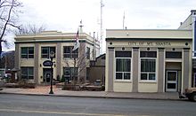 Mount Shasta Police Department and City Hall
In the state legislature Mount Shasta is located in the 4th Senate District, represented by Republican Doug LaMalfa, and in the 2nd Assembly District, represented by Republican Jim Nielsen. Federally, Mount Shasta is located in California's 2nd congressional district, which has a Cook PVI of R +13[15] and is represented by Republican Wally Herger.
Notable residents
- Former NFL defensive star Jason Sehorn is a 1989 graduate of Mount Shasta High School.
- Writer Anita Loos, author of the screenplay Gentlemen Prefer Blondes, was born in Sisson (now Mount Shasta) in 1888.
- Sherrie Russell Meline, the artist whose painting of a Ross's Goose was selected for the 2006-2007 Federal Duck Stamp, lives in Mount Shasta.
See also
References
- ^ U.S. Census
- ^ a b c Tourism information accessed 2008-03-05.
- ^ a b c Visitor activities access 2008-03-05.
- ^ a b c Activities accessed 2008-03-05.
- ^ a b c Siskiyou County information site accessed 2008-02-21.
- ^ a b Ross, John (2005). Trout Unlimited's Guide to America's 100 Best Trout Streams, Updated and Revised. Guilford, CT: The Lyons Press. ISBN 1592285856.
- ^ Brooks, Wade (2006). Fly fishing and the meaning of life. St. Paul, MN: Voyageur Press. ISBN 0760325758., p. 92. Excerpts of the text of this book are available here courtesy of Google Books.
- ^ a b Outdoor recreational activities in area accessed 2008-02-24.
- ^ ski information accessed 2008-03-05.
- ^ "US Gazetteer files: 2010, 2000, and 1990". United States Census Bureau. 2011-02-12. http://www.census.gov/geo/www/gazetteer/gazette.html. Retrieved 2011-04-23.
- ^ U.S. Geological Survey, Weed 15 Minute Quadrangle, U.S. Government Printing Office, Washington DC (1954)
- ^ Phase I Environmental Site Assessment,301 West Lake Street, Mount Shasta, California, Earth Metrics Incorporated, San Mateo, Ca., rpt. no. 10363, December 18, 1989
- ^ http://www.wrcc.dri.edu/cgi-bin/cliMAIN.pl?ca5983
- ^ All data are derived from the United States Census Bureau reports from the 2010 United States Census, and are accessible on-line here. The data on unmarried partnerships and same-sex married couples are from the Census report DEC_10_SF1_PCT15. All other housing and population data are from Census report DEC_10_DP_DPDP1. Both reports are viewable online or downloadable in a zip file containing a comma-delimited data file. The area data, from which densities are calculated, are available on-line here. Percentage totals may not add to 100% due to rounding. The Census Bureau defines families as a household containing one or more people related to the householder by birth, opposite-sex marriage, or adoption. People living in group quarters are tabulated by the Census Bureau as neither owners nor renters. For further details, see the text files accompanying the data files containing the Census reports mentioned above.
- ^ "Will Gerrymandered Districts Stem the Wave of Voter Unrest?". Campaign Legal Center Blog. http://www.clcblog.org/blog_item-85.html. Retrieved 2007-10-20.
External links
- Official homepage for the local newspaper Mount Shasta Herald
- Official homepage for the City of Mount Shasta
- Museum of the Siskiyou Trail
- Mount Shasta Collection at College of the Siskiyous
- Portal to Mount Shasta area and stories on residents
Shasta Cascade Mountains 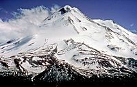
Bodies of Water Shasta Lake • Trinity Lake • Lake Almanor • Eagle Lake • Lake Oroville • Lake Siskiyou • Castle Lake • Lake McCloud • Manzanita Lake • Lake Britton • Whiskeytown LakeRivers Incorporated Cities Counties Parks Lassen Volcanic NP • Whiskeytown-Shasta-Trinity NRA • Lava Beds NM • Castle Crags Wilderness • Mount Shasta Wilderness • South Warner Wilderness • Ahjumawi Lava Springs SP • Bidwell-Sacramento River SP • McArthur-Burney Falls Memorial SP • Plumas-Eureka SP • Bidwell Mansion SHP • William B. Ide Adobe SHP • Woodson Bridge SRAMunicipalities and communities of Siskiyou County, California Cities 
CDPs Unincorporated
communitiesBlack Butte | Callahan | Cecilville | Forks of Salmon | Klamath River | Horse Creek | Pondosa | Sawyers Bar | Scott Bar | Seiad Valley | Somes Bar
Indian reservation Categories:- Mount Shasta
- Incorporated cities and towns in California
- Cities in Siskiyou County, California


![[2]](http://skimountaineer.com/CascadeSki/CascadeSnow/SnowdepthComparison.gif)
Wikimedia Foundation. 2010.