- Cloverdale, California
-
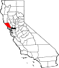
City of Cloverdale — City — Location in Sonoma County and the State of California
Coordinates: 38°47′57″N 123°1′2″W / 38.79917°N 123.01722°WCoordinates: 38°47′57″N 123°1′2″W / 38.79917°N 123.01722°W[1] Country  United States
State  California
County Sonoma Incorporated February 28, 1872[2] Government – Type Council-manager Area[3] – Total 2.648 sq mi (6.857 km2) – Land 2.648 sq mi (6.857 km2) – Water 0 sq mi (0 km2) 0% Elevation[4] 335 ft (102 m) Population (2010) – Total 8,618 – Density 3,254.5/sq mi (1,256.6/km2) – Demonym Cloverdalian Time zone PST (UTC-8) – Summer (DST) PDT (UTC-7) ZIP code 95425 Area code(s) 707 FIPS code 06-14190 GNIS feature ID 277489 Website http://www.cloverdale.net/ Cloverdale is a city in Sonoma County, California, United States. The San Francisco and North Pacific Railroad reached Cloverdale in 1872. The Cloverdale Rancheria of Pomo Indians of California is headquartered here. The population was 8,618 at the 2010 census.
Contents
Geography
Cloverdale is located in the northern portion of Sonoma County, and is the farthest city north in the San Francisco Bay Area, about 85 miles (135 km) north of San Francisco. U.S. 101 runs through the town, as does State Route 128.
The city has a total area of 2.6 square miles (6.7 km2), all of it land.
Cloverdale is located in the Wine Country, being part of the Alexander Valley AVA.
History
Cloverdale began as an early stage stop, known as Markleville, on the Rancho Rincon de Musalacon Mexican grant. In 1856 R. B. Markle and W. J. Miller bought 759 acres (3.1 km2), which included the present site of the town from Johnson Horrell. In 1859, James Abram Kleiser bought Markle's interest, and the town was laid out. The town was incorporated when the San Francisco and North Pacific Railroad arrived in 1872. By 1878, the railroad service provided three trains a day between Cloverdale and Ferries of San Francisco Bay.[5]
Demographics
2010
The 2010 United States Census[6] reported that Cloverdale had a population of 8,618. The population density was 3,255.1 people per square mile (1,256.8/km²). The racial makeup of Cloverdale was 6,458 (74.9%) White, 48 (0.6%) African American, 156 (1.8%) Native American, 98 (1.1%) Asian, 7 (0.1%) Pacific Islander, 1,530 (17.8%) from other races, and 321 (3.7%) from two or more races. Hispanic or Latino of any race were 2,824 persons (32.8%).
The Census reported that 8,530 people (99.0% of the population) lived in households, 22 (0.3%) lived in non-institutionalized group quarters, and 66 (0.8%) were institutionalized.
There were 3,182 households, out of which 1,087 (34.2%) had children under the age of 18 living in them, 1,769 (55.6%) were opposite-sex married couples living together, 294 (9.2%) had a female householder with no husband present, 159 (5.0%) had a male householder with no wife present. There were 232 (7.3%) unmarried opposite-sex partnerships, and 32 (1.0%) same-sex married couples or partnerships. 747 households (23.5%) were made up of individuals and 373 (11.7%) had someone living alone who was 65 years of age or older. The average household size was 2.68. There were 2,222 families (69.8% of all households); the average family size was 3.16.
The population was spread out with 2,054 people (23.8%) under the age of 18, 699 people (8.1%) aged 18 to 24, 2,154 people (25.0%) aged 25 to 44, 2,329 people (27.0%) aged 45 to 64, and 1,382 people (16.0%) who were 65 years of age or older. The median age was 39.7 years. For every 100 females there were 99.5 males. For every 100 females age 18 and over, there were 96.1 males.
There were 3,427 housing units at an average density of 1,294.4 per square mile (499.8/km²), of which 2,102 (66.1%) were owner-occupied, and 1,080 (33.9%) were occupied by renters. The homeowner vacancy rate was 4.1%; the rental vacancy rate was 4.9%. 5,522 people (64.1% of the population) lived in owner-occupied housing units and 3,008 people (34.9%) lived in rental housing units.
2000
As of the census[7] of 2000, there were 6,831 people, 2,495 households, and 1,741 families residing in the city. The population density was 2,708.3 people per square mile (1,046.6/km²). There were 2,619 housing units at an average density of 1,038.3 per square mile (401.3/km²). The racial makeup of the city was 68.7% White, 0.18% African American, 3.0% Native American, 1.04% Asian, 0.07% Pacific Islander, 2.30% from other races, and 15.3% from two or more races. Hispanic or Latino of any race were 26.7% of the population.
There were 2,495 households out of which 36.4% had children under the age of 18 living with them, 55.3% were married couples living together, 9.1% had a female householder with no husband present, and 30.2% were non-families. 24.9% of all households were made up of individuals and 12.7% had someone living alone who was 65 years of age or older. The average household size was 2.71 and the average family size was 3.24.
In the city the population was spread out with 27.3% under the age of 18, 8.5% from 18 to 24, 28.3% from 25 to 44, 21.7% from 45 to 64, and 14.3% who were 65 years of age or older. The median age was 36 years. For every 100 females there were 99.2 males. For every 100 females age 18 and over, there were 96.5 males.
The median income for a household in the city was $42,309, and the median income for a family was $50,000. Males had a median income of $40,036 versus $26,610 for females. The per capita income for the city was $19,750. About 7.2% of families and 10.4% of the population were below the poverty line, including 11.6% of those under age 18 and 9.5% of those age 65 or over.
Politics
In the state legislature Cloverdale is located in the 2nd Senate District, represented by Democrat Noreen Evans, and in the 1st Assembly District, represented by Democrat Wes Chesbro. Federally, Cloverdale is located in California's 1st congressional district, represented by Democrat Mike Thompson.
Transportation
Cloverdale is at the junction of U.S. 101 and State Route 128. The city operates Cloverdale Transit and Cloverdale Municipal Airport. Inter-city transit is provided by Sonoma County Transit. Planning is in progress for Sonoma-Marin Area Rail Transit (SMART), a commuter rail service in Sonoma and Marin Counties from Cloverdale to a bay ferry terminal in Larkspur.
See also
References
- ^ "US Gazetteer files: 2010, 2000, and 1990". United States Census Bureau. 2011-02-12. http://www.census.gov/geo/www/gazetteer/gazette.html. Retrieved 2011-04-23.
- ^ "Dates of incorporation". http://www.cacities.org/resource_files/20457.IncorpDateLO.doc. Retrieved 2008-07-11.
- ^ U.S. Census
- ^ U.S. Geological Survey Geographic Names Information System: Cloverdale
- ^ City of Cloverdale General Plan
- ^ All data are derived from the United States Census Bureau reports from the 2010 United States Census, and are accessible on-line here. The data on unmarried partnerships and same-sex married couples are from the Census report DEC_10_SF1_PCT15. All other housing and population data are from Census report DEC_10_DP_DPDP1. Both reports are viewable online or downloadable in a zip file containing a comma-delimited data file. The area data, from which densities are calculated, are available on-line here. Percentage totals may not add to 100% due to rounding. The Census Bureau defines families as a household containing one or more people related to the householder by birth, opposite-sex marriage, or adoption. People living in group quarters are tabulated by the Census Bureau as neither owners nor renters. For further details, see the text files accompanying the data files containing the Census reports mentioned above.
- ^ "American FactFinder". United States Census Bureau. http://factfinder.census.gov. Retrieved 2008-01-31.
News from Cloverdale
Municipalities and communities of Sonoma County, California Cities and towns Cloverdale | Cotati | Healdsburg | Petaluma | Rohnert Park | Santa Rosa | Sebastopol | Sonoma | Windsor
CDPs Bloomfield | Bodega | Bodega Bay | Boyes Hot Springs | Carmet | Cazadero | El Verano | Eldridge | Fetters Hot Springs-Agua Caliente | Forestville | Fulton | Geyserville | Glen Ellen | Graton | Guerneville | Jenner | Kenwood | Larkfield-Wikiup | Monte Rio | Occidental | Penngrove | Roseland | Salmon Creek | Sea Ranch | Sereno del Mar | Temelec | Timber Cove | Valley Ford
Unincorporated
communitiesAnnapolis | Asti | Camp Meeker | Duncans Mills | Freestone | Guernewood Park | Lakeville | Mark West | Mark West Springs | Rio Dell | Rio Nido | Schellville | Stewarts Point | Two Rock | Venado | Villa Grande | Vineburg
Indian reservations Categories:- Incorporated cities and towns in California
- Cities in Sonoma County, California
- Cities in the San Francisco Bay Area
- Populated places established in 1872


Wikimedia Foundation. 2010.