- Columbia, California
-
Columbia — census-designated place — Main Street. Columbia. Location in Tuolumne County and the state of California
Coordinates: 38°2′2″N 120°24′4″W / 38.03389°N 120.40111°WCoordinates: 38°2′2″N 120°24′4″W / 38.03389°N 120.40111°W Country  United States
State  California
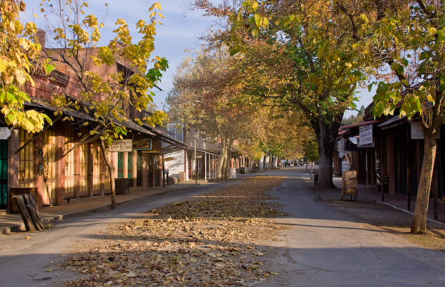
County Tuolumne Area[1] - Total 5.979 sq mi (15.487 km2) - Land 5.961 sq mi (15.440 km2) - Water 0.018 sq mi (0.047 km2) 0.31% Elevation 2,139 ft (652 m) Population (2000) - Total 2,297 - Density 384.2/sq mi (148.3/km2) Time zone Pacific (PST) (UTC-8) - Summer (DST) PDT (UTC-7) ZIP code 95310 Area code(s) 209 FIPS code 06-14904 GNIS feature ID 0277490  The picturesque Columbia in the Fall.
Columbia is a former California Gold Rush boomtown located in the Sierra Nevada foothills. The central portion of the town is preserved as a California state historic park and a National Historic Landmark that preserves the original, gold-rush-town flavor of the town, once dubbed the "Gem of the Southern Mines." Founded in 1850 by Mexican gold miners, it is in Tuolumne County, California, United States. Although only about 2,000 people now live in this region near Sonora, California, at its height it was California's second-largest city. It was even considered briefly as a site for the state capitol of California. In 1854 the bulk of the town burned down and was re-built with brick and iron structures that survive to this day. Columbia's main street, part of the Columbia State Historic Park, is closed to automobile traffic but is open to horses, carriages, bicycles and pedestrians.
The town, now technically a census-designated place (CDP), is located along State Route 49 just north of Sonora. The US Postal Service ZIP code for the community is 95310. Wired telephones in Columbia work out of the Sonora central office. The population was 2,297 at the 2010 census.
Major points of interest in the area include Columbia Community College, a two-year, community college. Columbia Airport (FAA designator: O22) includes one 4,670-foot (1,420 m) runway and is busy with firefighting aircraft during summer. The annual Columbia Fire Muster here is often the earliest of California's summer musters.
Contents
History
 A parade is part of the annual firefighter's muster in May.
Within weeks of the discovery of gold in the vicinity of Columbia, thousands of miners arrived and the population climbed to 5,000. By 1852, there were 8 hotels, 4 banks, 17 general stores, 2 firehouses, 2 bookstores, 1 newspaper, 3 churches, and over 40 drinking/gambling establishments. In 1854, Columbia's first fire destroyed 6 city blocks. The town was rebuilt using brick and iron materials. In 1857, another fire burned down nearly everything else, except the brick buildings.
In 1851, the local community brass band, a popular institution, greeted the arrival of the first white woman in town.[2]
The Columbia school house was built in 1860, renovated in 1872, and finally closed in 1937. In 1947, it was purchased by the state of California for $1 and incorporated into the state-historic park.
By 1860, the gold mined in Columbia was diminishing rapidly. The only land left to mine was in the city itself. Miners dug under buildings and tore down houses to get at the gold beneath the city. The nearby town of Copperopolis had discovered copper and was experiencing a boom. The bricks from the destroyed buildings of Columbia were sold to Copperopolis for construction purposes.
Between 1850 and the early 1900s, $150 million in gold was removed from the surrounding hills.
 Columbia State Historic Park, August 2005
Columbia never became a ghost town. In 1945, California created Columbia State Historic Park from the remains of the historical buildings of the city.
Rev. John Steele wrote his accounts of the "Indians" of Columbia in his memoirs In Camp and Cabin during his time in the gold rush era. The Native Americans of the village of Columbia were Mi-wuk.
Notable people
- Peter Muldoon, Roman Catholic bishop
http://en.wikipedia.org/wiki/Jon_R._Cavaiani
Geography
Columbia is located at 38°2′2″N 120°24′4″W / 38.03389°N 120.40111°W (38.033881, -120.401172)[3] at an altitude of about 2,100 feet (650 m).
According to the United States Census Bureau, the CDP has a total area of 6.0 square miles (16 km2). Only 0.31% of the total area is covered by water.
Demographics
 A Columbia Fire Dept. muster team member.
2010
The 2010 United States Census[4] reported that Columbia had a population of 2,297. The population density was 384.1 people per square mile (148.3/km²). The racial makeup of Columbia was 2,064 (89.9%) White, 27 (1.2%) African American, 26 (1.1%) Native American, 29 (1.3%) Asian, 1 (0.0%) Pacific Islander, 27 (1.2%) from other races, and 123 (5.4%) from two or more races. Hispanic or Latino of any race were 171 persons (7.4%).
The Census reported that 2,226 people (96.9% of the population) lived in households, 71 (3.1%) lived in non-institutionalized group quarters, and 0 (0%) were institutionalized.
There were 1,002 households, out of which 243 (24.3%) had children under the age of 18 living in them, 432 (43.1%) were opposite-sex married couples living together, 125 (12.5%) had a female householder with no husband present, 51 (5.1%) had a male householder with no wife present. There were 53 (5.3%) unmarried opposite-sex partnerships, and 4 (0.4%) same-sex married couples or partnerships. 330 households (32.9%) were made up of individuals and 142 (14.2%) had someone living alone who was 65 years of age or older. The average household size was 2.22. There were 608 families (60.7% of all households); the average family size was 2.80.
The population was spread out with 470 people (20.5%) under the age of 18, 201 people (8.8%) aged 18 to 24, 406 people (17.7%) aged 25 to 44, 735 people (32.0%) aged 45 to 64, and 485 people (21.1%) who were 65 years of age or older. The median age was 47.8 years. For every 100 females there were 97.3 males. For every 100 females age 18 and over, there were 92.9 males.
There were 1,117 housing units at an average density of 186.8 per square mile (72.1/km²), of which 661 (66.0%) were owner-occupied, and 341 (34.0%) were occupied by renters. The homeowner vacancy rate was 2.1%; the rental vacancy rate was 8.1%. 1,389 people (60.5% of the population) lived in owner-occupied housing units and 837 people (36.4%) lived in rental housing units.
2000
As of the census[5] of 2000, there were 2,405 people, 1,063 households, and 659 families residing in the CDP. The population density was 389.7 people per square mile (150.5/km²). There were 1,162 housing units at an average density of 188.3 per square mile (72.7/km²). The racial makeup of the CDP was 90.10% White, 0.87% African American, 1.41% Native American, 1.29% Asian, 0.12% Pacific Islander, 1.29% from other races, and 4.91% from two or more races. Hispanic or Latino of any race were 6.90% of the population.
There were 1,063 households out of which 22.6% had children under the age of 18 living with them, 44.3% were married couples living together, 13.0% had a female householder with no husband present, and 38.0% were non-families. 29.7% of all households were made up of individuals and 14.3% had someone living alone who was 65 years of age or older. The average household size was 2.18 and the average family size was 2.65.
In the CDP the population was spread out with 20.2% under the age of 18, 10.0% from 18 to 24, 18.8% from 25 to 44, 28.1% from 45 to 64, and 22.9% who were 65 years of age or older. The median age was 46 years. For every 100 females there were 89.1 males. For every 100 females age 18 and over, there were 88.4 males.
The median income for a household in the CDP was $29,173, and the median income for a family was $35,000. Males had a median income of $40,729 versus $23,750 for females. The per capita income for the CDP was $18,731. About 20.2% of families and 19.0% of the population were below the poverty line, including 37.7% of those under age 18 and 1.4% of those age 65 or over.
Filming location
A few of the more than 100 movies and TV series filmed in Columbia:
- Sierra Spirits, 2007
- Behind the Mask of Zorro, 2005
- Radio Flyer, 1992
- Blood Red, 1989
- Pale Rider, 1985
- The Shadow Riders, 1982
- Joe Dancer: The Big Trade, 1981
- The Last Ride of the Dalton Gang, 1979
- Law of the Land, 1976
- Little House on the Prairie, 1974
- Something for a Lonely Man, 1968
- Rage at Dawn, 1955
- Texas Lady, 1955
- Teh Cimarron Kid, 1952
- Death Valley Days, 1952
- High Noon, 1952
- The Lone Ranger, The, 1949
- Rustlers' Valley, 1937
- Wells Fargo, 1937
- The Best Bad Man, 1925
Politics
In the state legislature Columbia is located in the 14th Senate District, represented by Republican Tom Berryhill, and in the 25th Assembly District, represented by Republican Kristin Olsen. Federally, Columbia is located in California's 19th congressional district, which has a Cook PVI of R +10[6] and is represented by Republican Jeff Denham.
Notes
- ^ U.S. Census
- ^ Abel, pg. 133
- ^ "US Gazetteer files: 2010, 2000, and 1990". United States Census Bureau. 2011-02-12. http://www.census.gov/geo/www/gazetteer/gazette.html. Retrieved 2011-04-23.
- ^ All data are derived from the United States Census Bureau reports from the 2010 United States Census, and are accessible on-line here. The data on unmarried partnerships and same-sex married couples are from the Census report DEC_10_SF1_PCT15. All other housing and population data are from Census report DEC_10_DP_DPDP1. Both reports are viewable online or downloadable in a zip file containing a comma-delimited data file. The area data, from which densities are calculated, are available on-line here. Percentage totals may not add to 100% due to rounding. The Census Bureau defines families as a household containing one or more people related to the householder by birth, opposite-sex marriage, or adoption. People living in group quarters are tabulated by the Census Bureau as neither owners nor renters. For further details, see the text files accompanying the data files containing the Census reports mentioned above.
- ^ "American FactFinder". United States Census Bureau. http://factfinder.census.gov. Retrieved 2008-01-31.
- ^ "Will Gerrymandered Districts Stem the Wave of Voter Unrest?". Campaign Legal Center Blog. http://www.clcblog.org/blog_item-85.html. Retrieved 2008-02-10.
References
- Abel, E. (2000). Singing the New Nation: How Music Shaped the Confederacy, 1861-1865. Mechanicsburg, Pennsylvania: Stackpole Books. ISBN 0811702286.
External links
- Columbia's Official Website
- Photographic Tour of the Bell Marble Quarry, Columbia, CA, on Stone Quarries and Beyond.
- Photographic Tour of One of the Historic Columbia Marble Quarries, Columbia, CA, on Stone Quarries and Beyond.
- myMotherLode.com Community Guide
Municipalities and communities of Tuolumne County, California City 
CDPs Cedar Ridge | Chinese Camp | Cold Springs | Columbia | East Sonora | Groveland | Jamestown | Long Barn | Mi-Wuk Village | Mono Vista | Phoenix Lake | Pine Mountain Lake | Sierra Village | Soulsbyville | Strawberry | Tuolumne City | Tuttletown | Twain Harte
Unincorporated
communitiesBlanchard | Buchanan | Bumblebee | Confidence | Dardanelle | Deadwood | Groveland-Big Oak Flat | Mather | Moccasin | Phoenix Lake-Cedar Ridge | Pinecrest | Standard
Categories:- Census-designated places in Tuolumne County, California
- California Gold Rush


Wikimedia Foundation. 2010.