Meikle Carewe Hill

Meikle Carewe Hill
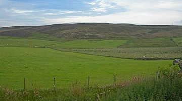
Meikle Carewe Hill. Author: C. Michael Hogan

Meikle Carewe Hill is a landform in Aberdeenshire, Scotland within the Mounth Range of the Grampian Mountains. (Grid Reference NO 921 828)[1] The peak elevation of this mountain is 266 metres above mean sea level. Meikle Carewe is a prominent landform visible from a number of coastal hills such as Kempstone Hill and Megray Hill; it also forms a major backdrop to the community of Netherley.

Contents

Geology and hydrology

This mountain is covered virtually entirely with moorland. Its northwestern slopes drain to the Cairnie Burn, whilst the northern and eastern slopes drain to Crynoch Burn. The western slopes yield surface runoff that drains to Cowton Burn. Curlethney Hill is situated approximately 0.9 kilometers to the east of Meikle Carewe Hill; surface runoff and drainage from Curlethney Hill also drain north to Crynoch Burn, at reaches above the Red Moss. Waters within the Red Moss are decidedly acidic, with measured summer pH values in the range of 5.68. These low pH levels may be caused in part by the peat drainage from the moorland on Meikle Carewe Hill.

Wind farm proposal

Renewable Energy Resources has an application pending before the Aberdeenshire Council to create a windfarm for electrical power generation using Meikle Carewe Hill and nearby high ground to install twelve wind turbines, five of which are proposed for Meikle Carewe Hill itself. Each turbine would reach a height of 70 metres above grade level, and the entire complex could generate enough power to supply the equivalent of 5000 homes [2]. Environmental concerns over the proposal include noise pollution, visual impact[3] and ecological disturbance.

See also

References

  1. ^ United Kingdom Ordnance Survey Map Landranger 45, Stonehaven and Banchory, 1:50,000 scale, 2004
  2. ^ Meikle Carewe Windfarm Website
  3. ^ Meikle Carewe Windfarm Action Group website

Coordinates: 57°01′08″N 2°17′07″W / 57.0188°N 2.2853°W / 57.0188; -2.2853


Wikimedia Foundation. 2010.

Игры ⚽ Нужно сделать НИР?

Look at other dictionaries:

  • Curlethney Hill — is a landform in Aberdeenshire, Scotland within the Mounth Range of the Grampian Mountains. (Grid Reference NO 918 839)[1] The peak elevation of this mountain is 246 metres above mean sea level. This landform lies slightly southwest of the… …   Wikipedia

  • Kempstone Hill — is a landform in Aberdeenshire, Scotland within the Mounth Range of the Grampian Mountains. [United Kingdom Ordnance Survey Map Landranger 45, Stonehaven and Banchory, 1:50,000 scale, 2004] The peak elevation of this mountain is 132 metres above… …   Wikipedia

  • Megray Hill — is a low lying coastal mountainous landform in Aberdeenshire, Scotland within the Mounth Range of the Grampian Mountains.[1] The peak elevation of this mountain is 120 metres above mean sea level. This hill has been posited as a likely location… …   Wikipedia

  • Saddle Hill (Aberdeenshire) — Saddle Hill is a low lying mountain in eastern Aberdeenshire, Scotland within the Mounth Range of the Grampian Mountains. [United Kingdom Ordnance Survey Map Landranger 45, Stonehaven and Banchory, 1:50,000 scale, 2004] The peak elevation of this …   Wikipedia

  • Burn of Monboys — HydrologyThe headwaters of the Burn of Monboys rise on the southern and western slopes of the Meikle Carewe Hill where the stream flows downslope at a first westerly and thence southerly as it makes its way to discharge to the Cowie Water. The… …   Wikipedia

  • Netherley, Aberdeenshire — The Old Netherley School Netherley, Scotland is a village in Aberdeenshire, situated approximately five miles northwest of Stonehaven.[1] Netherley is located in the Mounth area of the Grampian …   Wikipedia

  • Crynoch Burn — is a stream in Aberdeenshire that is tributary to the River Dee.[1] This stream rises somewhat above Netherley and flows near Netherley House; and thence into the Red Moss, a significant natural bog habitat; thence near the historic Lairhillock… …   Wikipedia

  • Durris Forest — is a chiefly coniferous forest south of the River Dee approximately three kilometres west of Netherley in Aberdeenshire, Scotland.[1] (Ordnance Survey, 2004) The A957 road forms the southwest boundary of Durris Forest, separating it from… …   Wikipedia

  • Elsick Mounth — The Elsick Mounth is an ancient trackway crossing the Grampian Mountains in the vicinity of Netherley, Scotland. This trackway was one of the few means of traversing the Grampian Mounth area in prehistoric and medieval times. [W. Douglas Simpson …   Wikipedia

  • Alexander Silver — was a wealthy East India trader, who lived in Netherley, Aberdeenshire, Scotland in the late 1700s; he and his son George Silver were noted agricultural innovators of their era. [ [http://books.google.com/books?id=nA4AAAAAQAAJ pg=PA321 lpg=PA321… …   Wikipedia

Share the article and excerpts

Direct link
Do a right-click on the link above
and select “Copy Link”