- Mitcham Eastfields railway station
-
Mitcham Eastfields 
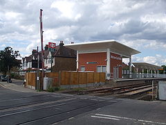
Station building, to the north of the level crossing on Eastfields Road (platforms staggered)
 Mitcham Eastfields
Location of Mitcham Eastfields in Greater LondonLocation Eastfields and Mitcham Local authority London Borough of Merton Managed by Southern Station code MTC Number of platforms 2 Accessible  [1]
[1]Fare zone 3 National Rail annual entry and exit 2008-09 0.199 million[2] 2009-10  0.302 million[2]
2 June 2008 Opened List of stations Underground · National Rail External links Departures • Layout Facilities • Buses Coordinates: 51°24′28″N 0°09′17″W / 51.4077°N 0.1547°W
Mitcham Eastfields (initially known as Eastfields during planning and construction)[3] is a railway station in London, United Kingdom, which opened on 2 June 2008.[4] The station is located at Eastfields Road level crossing,[3] in an area previously poorly served by public transport. The nearest station was Mitcham Junction, which along with Mitcham tram stop, was over a mile away from the district.[5] It is in fare zone 3.[6]
Contents
History
Proposals for the station have apparently existed since the 1930s.[3] Planning permission was granted by the London Borough of Merton in August 2007[7]. Construction started in October 2007. Following consultation, there were hopes to have the station open by December 2007. The opening was originally scheduled for 19 May 2008. However, on 20 May 2008 the station reopening was postponed as Network Rail did not feel the station would be ready to open until early June.[8]. The station was planned to open in the morning of Monday 2 June but opened later in the afternoon due to delays involving safety inspections. The station opened at 16:00 with the first train arriving at 16:11.
Design
The station cost £6m, and was the second station to be built to a modular design developed by Network Rail, which is also used at Corby railway station and Greenhithe railway station which was the first to be constructed.[9] The platforms are 170 m long, with a building on the up (northbound) platform. The platforms are arranged so that each is situated beyond the level crossing in the direction of travel, allowing the crossing to be reopened while trains are stopped at the station, minimising the disruption to road traffic. However this means that passengers must cross Eastfields Road (no controlled crossing at present) if they wish to purchase a ticket on the northbound side and then travel southbound. The footbridge on the southbound side only allows safe movement over the railway and not the road.
Services
Mitcham Eastfields station is served by Southern services from Victoria and First Capital Connect services (Monday to Saturday only) on the Sutton Loop of Thameslink[3][6]. The current journey time on this line between Mitcham Junction station and Streatham is six minutes. Victoria can be reached within 20 minutes.
The typical off-peak train service per hour is:
- 2tph (trains per hour) to St Albans via Herne Hill and London Blackfriars
- 2tph to London Victoria via Clapham Junction
- 2tph to Wimbledon via Sutton
- 2tph to Epsom via Hackbridge and Sutton
Preceding station  National Rail
Following station Balham Southern
Sutton & Mole Valley LinesMitcham Junction Streatham Streatham First Capital Connect
Sutton LoopMitcham Junction Transport links
London bus routes 152 and 463.
Usage statistics
Merton Council's magazine reported in June 2009 that 52,000 journeys have been made from the station.[10]
References
- ^ "Network Map". Southern. http://www.southernrailway.com/your-journey/network-map/?access=on. Retrieved 2 January 2010.
- ^ a b "Station usage". Rail statistics. Office of Rail Regulation. 30 April 2010. http://www.rail-reg.gov.uk/server/show/nav.1529. Retrieved 17 January 2011. Please note: Some methodology may vary year on year.
- ^ a b c d "Merton Council gives green light to Eastfields railway station" (Press release). London Borough of Merton. 2007-08-24. http://www.merton.gov.uk/press-release-details.asp?id=1587. Retrieved 2007-09-28.
- ^ "Mitcham Eastfields station to open today - LATEST". Southern Railway. http://www.southernrailway.com/news.php?id=166&u=news.php. Retrieved 2008-06-02.[dead link]
- ^ "Eastfields Station". TFL. 2006-03-11. http://www.alwaystouchout.com/project/55. Retrieved 2007-09-28.
- ^ a b "London Connections map". ATOC. 2008-02-01. Archived from the original on 2007-09-29. http://web.archive.org/web/20070929174016/http://www.nationalrail.co.uk/system/galleries/download/print_maps/LondonConnections.pdf. Retrieved 2008-02-23.
- ^ "Residents' questions answered on new Eastfields station" (Press release). London Borough of Merton. 2007-07-17. http://www.merton.gov.uk/press-release-details.asp?id=1587. Retrieved 2007-07-18.
- ^ ""First Capital Connect - Mitcham Eastfields station"". http://www.firstcapitalconnect.co.uk/Main.php?iCmsPageId=331. Retrieved 2008-05-20.[dead link]
- ^ "Modular station opens this month". Railway Gazette International. 2008-05-01. http://www.railwaygazette.com/news/single-view/view//modular-station-opens-this-month.html. Retrieved 2008-05-02.
- ^ . London Borough of Merton. June-July 2009. http://www.merton.gov.uk/mymerton. Retrieved 2009-06-09.
External links
- Eastfields station plan (3.47 MiB)
- A photo of the station under construction from Railway Gazette International.
Gallery
-

Northbound platform and station building viewed from southbound platform
-

Southbound platform viewed from northbound platform
-

Southbound platform viewed from northbound platform, with level crossing closed
-

Southbound platform (staggered) looking south
-

Northbound platform (staggered) looking north
-

Signage on station building, adjacent to northbound platform, with Southern branding.
Categories:- Stations in London fare zone 3
- Railway stations in Merton
- Railway stations opened by Network Rail
- Railway stations opened in 2008
- Railway stations served by Southern
- Railway stations served by First Capital Connect
- DfT Category E stations


Wikimedia Foundation. 2010.