- Old Saybrook, Connecticut
-
Old Saybrook, Connecticut — Town — Saybrook Breakwater Light
SealLocation within Middlesex County, Connecticut
Coordinates: 41°17′38″N 72°22′57″W / 41.29389°N 72.3825°WCoordinates: 41°17′38″N 72°22′57″W / 41.29389°N 72.3825°W Country  United States
State  Connecticut
NECTA New Haven Region Connecticut River Estuary Incorporated 1854 Government - Type Selectman-town meeting - First selectman Carl Fortuna Area - Total 21.6 sq mi (55.9 km2) - Land 15.0 sq mi (38.8 km2) - Water 6.6 sq mi (17.0 km2) Elevation 39 ft (12 m) Population (2005) - Total 10,512 - Density 701/sq mi (271/km2) Time zone Eastern (UTC-5) - Summer (DST) Eastern (UTC-4) ZIP code 06475 Area code(s) 860 FIPS code 09-57320 GNIS feature ID 0213484 Website http://www.oldsaybrookct.org/ Old Saybrook is a town in Middlesex County, Connecticut, United States. The population was 10,367 at the 2000 census. It contains the incorporated borough of Fenwick, as well as the census-designated places of Old Saybrook Center and Saybrook Manor.
Contents
History
Shortly after constructing their first settlement on the island of Manhattan, Dutch explorers established a short-lived trading post at present day Old Saybrook. The post was named Kievits Hoek, meaning "Plover's Corner" in English. Kievits Hoek was soon abandoned as the Dutch began to focus more on their new trading post, Fort Goede Hoop (Huys de Goede Hoop), at present-day Hartford.
The Saybrook Colony was established in late 1635 at the mouth of the Connecticut River, in what is today Old Saybrook and environs. John Winthrop, the Younger, son of the Governor of the Massachusetts Bay Colony, was designated Governor by the group that claimed possession of the land via a deed of conveyance from the Earl of Warwick. Winthrop was aided by Colonel George Fenwick and Captain Lion Gardiner. As the principals of the group who had planned to settle the colony were supporters of Oliver Cromwell and remained in England during the English Civil War, the colony struggled. In 1644, Fenwick agreed to merge the colony with the more vibrant Connecticut Colony a few miles up river, which purchased the land and fort from him.
The design of the Flag of Connecticut comes from the seal of Saybrook Colony. The seal was brought from England by Colonel George Fenwick, and depicted 15 grapevines and a hand in the upper left corner with a scroll reading "Qui Sustinet Transtulit".
In 1659, settlers from Saybrook purchased land from Chief Uncas, leader of the Mohegan Native American tribe, to found Norwich, Connecticut.
On October 9, 1701 the Collegiate School of Connecticut was chartered in Old Saybrook. It moved to New Haven in 1716, and was later renamed Yale University.
The Turtle - the first American submarine - was invented in Westbrook Connecticut in 1775 by David Bushnell; a replica is housed at Old Saybrook Senior High School.
Recent developments
In early 2007, plans were established to return the former town hall building to its original use as a theater. The theatre was completed in 2009 and is named "Katharine Hepburn Cultural Arts Center and Theater".
The town has committed spending almost $2 million on the renovation, and at least $810,000 is to be contributed by the state. A committee is attempting to raise another $2.5 million, partly for the renovation and to add two wings, but also for an endowment. The structure was originally built in 1901 and was a theater until the 1940s. After renovations, the theater will seat 250, and Hepburn memorabilia will be displayed there.[1]
Notable residents
- Vin Baker — Professional basketball player in the NBA (1993–2006)
- Art Carney — Academy Award– and Emmy Award-winning American actor in film, stage, television and radio.
- Katharine Hepburn — A four-time Academy Award–winning American star of film, television and stage, she lived in the borough of Fenwick.
- John Clellon Holmes — American writer and poet associated with the "Beat Generation" crowd.
- Ann Petry — African-American novelist, journalist and biographer.
- Elmer Eric Schattschneider — A prominent political scientist and former president of the American Political Science Association from 1956 to 1957
Geography
According to the United States Census Bureau, the town has a total area of 21.6 square miles (56.0 km²), of which, 15.0 square miles (39.0 km²) of it is land and 6.6 square miles (17.0 km²) of it (30.45%) is water.
Principal communities
- Chalker Beach
- Cornfield Point
- District of Fencove
- Borough of Fenwick
- District of Fenwood
- Indian Town
- Knollwood
- Old Saybrook Center (includes Saybrook Point)
- District of Otter Cove
- Saybrook Manor
Climate
The lower Connecticut River Valley, where the Connecticut River meets Long Island Sound, is generally regarded to be one of the mildest parts of Connecticut. Under the Köppen climate classification system, Old Saybrook and neighboring Old Lyme enjoy relatively mild humid subtropical climate.
The definition of this climate is for the coldest month's mean temperature to be between −3 °C (26.6 °F) and 18 °C (64 °F), and the warmest month to be above 22 °C (72 °F). Old Saybrook and Old Lyme share a mean temperature of 31 °F (−1 °C) in their coldest month (January) and a mean temperature of 73 °F (23 °C) in their warmest month (July).[2] Temperatures are moderated not only by Long Island Sound, but also by the Connecticut River and the large system of marshes and tidal rivers in and around its delta. In the wintertime, mean temperatures here average 5.5 °F (−14.7 °C) warmer than in northern Connecticut; Old Saybrook's nighttime lows in January exceed Windsor Locks' by 7 °F (−14 °C) and its daytime highs for the same month exceed Windsor Locks' by 4 °F (−16 °C).[3]
Oftentimes, a winter storm that brings blizzard-like conditions to the northern half of the state will only bring a chilly rain to areas along the immediate coast. Average annual snowfall tallies around 20 inches,[4] around half as much as inland areas[5] and about the same, for example, as the area in and around Baltimore, Maryland.[6] The maritime influence in the area also depresses summertime temperatures (due to a sea breeze which does not reach areas further inland).
Due to its uniquely mild climate, this part of Connecticut is one of the few locales in which so-called "subtropical indicator" plants can successfully be cultivated. Southern Magnolias,[7] Needle Palms, Windmill palm, Loblolly Pines, and Crape Myrtles are examples of subtropical plants that grow with ease in this climate while they struggle to survive in the stereotypical New England climate inland and to the north.
Demographics
As of the census of 2000, there were 10,367 people, 4,184 households, and 2,920 families residing in the town. The population density was 689.5 people per square mile (266.1/km²). There were 5,357 housing units at an average density of 356.3 per square mile (137.5/km²). The racial makeup of the town was 95.75% White, 1.01% African American, 0.08% Native American, 1.72% Asian, 0.07% Pacific Islander, 0.45% from other races, and 0.93% from two or more races. Hispanic or Latino of any race were 1.87% of the population.
There were 4,184 households out of which 27.2% had children under the age of 18 living with them, 59.4% were married couples living together, 7.6% had a female householder with no husband present, and 30.2% were non-families. 25.4% of all households were made up of individuals and 12.9% had someone living alone who was 65 years of age or older. The average household size was 2.41 and the average family size was 2.90.
In the town the population was spread out with 21.7% under the age of 18, 4.1% from 18 to 24, 25.2% from 25 to 44, 27.6% from 45 to 64, and 21.5% who were 65 years of age or older. The median age was 44 years. For every 100 females there were 89.5 males. For every 100 females age 18 and over, there were 86.3 males.
The median income for a household in the town was $62,742, and the median income for a family was $72,868. Males had a median income of $48,527 versus $36,426 for females. The per capita income for the town was $30,720. About 1.5% of families and 4.5% of the population were below the poverty line, including 1.9% of those under age 18 and 9.7% of those age 65 or over.
Transportation
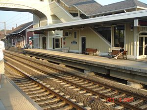 The platforms at the Old Saybrook train station.
 Main article: Old Saybrook (Amtrak station)
Old Saybrook's train station opened in 1873 and was rebuilt in 2002. Amtrak, the national rail passenger system, provides daily service along the Northeast Corridor to Boston, New York and points south. The high-speed Acela Express passes through Old Saybrook but does not stop; service is provided by the conventional Northeast Regional. The Connecticut Department of Transportation provides regular commuter service to New Haven and Stamford via the Shore Line East.
The Estuary Transit District provides public transportation services throughout Old Saybrook and the surrounding towns through its 9 Town Transit services.
National Register of Historic Places in Old Saybrook
- Black Horse Tavern, added December 1, 1978
- Elisha Bushnell House, added November 29, 1978
- Connecticut Valley Railroad Roundhouse and Turntable Site, added April 28, 1994
- Jedidiah Dudley House, added April 12, 1982
- Samuel Eliot House, added November 9, 1972
- General William Hart House, added November 9, 1972
- James Pharmacy, added August 5, 1994
- Lynde Point Lighthouse, added May 29, 1990
- Old Saybrook South Green, added September 3, 1976
- Parker House, added November 29, 1978
- Humphrey Pratt Tavern, added November 7, 1972
- Saybrook Breakwater Lighthouse, added May 29, 1990
- William Tully House, added March 15, 1982
- Ambrose Whittlesey House, added August 23, 1985
- John Whittlesey, Jr. House, added October 26, 1984
See also
- Saybrook, Illinois is named in honor of Old Saybrook.
Notes
- ^ Wojtas, Joe, "Hepburn's Town to Honor Her With a Theater", The New York Times, "Connecticut" section, page 2, February 18, 2007
- ^ "Average Weather for Old Saybrook, CT." Weather.com. N.p., 2010. Web. 17 Jan. 2010. <http://www.weather.com/weather/wxclimatology/monthly/graph/USCT0161?from=month_bottomnav_undeclared>.
- ^ "Climatology Comparison for Old Saybrook, CT." Weather.com. N.p., 2010. Web. 17 Jan. 2010. <http://www.weather.com/weather/wxclimatology/compare/USCT0161?sfld1=Old%20Saybrook,%20CT&sfld2=Windsor%20Locks,%20CT&clocid1=USCT0161&clocid2=>.
- ^ "NOWData - NOAA Online Weather Data." National Oceanic and Atmospheric Association. N.p., 2010. Web. 17 Jan. 2010. <http://nowdata.rcc-acis.org/OKX/pubACIS_results>.
- ^ "NOWData - NOAA Online Weather Data." National Oceanic and Atmospheric Association. N.p., 2010. Web. 17 Jan. 2010. <http://nowdata.rcc-acis.org/BOX/pubACIS_results>.
- ^ "NOWData - NOAA Online Weather Data." National Oceanic and Atmospheric Association. N.p., 2010. Web. 17 Jan. 2010. <http://nowdata.rcc-acis.org/LWX/pubACIS_results>.
- ^ "Magnolia grandiflora 'Edith Bogue'.'" PlantFiles. Dave's Garden, 2010. Web. 17 Jan. 2010. <http://davesgarden.com/guides/pf/go/2828/>.
External links
 State of Connecticut
Topics - Index
- Culture
- Constitution
- Delegations
- Elections
- Geography
- Government
- History
- Images
- People
- Visitor Attractions
Regions Counties Cities Places Municipalities and communities of Middlesex County, Connecticut City 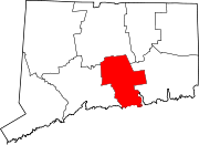
Towns Chester | Clinton | Cromwell | Deep River | Durham | East Haddam | East Hampton | Essex | Haddam | Killingworth | Middlefield | Old Saybrook | Portland | Westbrook
Borough Unincorporated
communitiesCenterbrook | Essex Village | Higganum | Ivoryton | Lake Pocotopaug | Leesville | Middle Haddam | Millington | Moodus | Saybrook Manor
Categories:- Old Saybrook, Connecticut
- Towns in Middlesex County, Connecticut
- Populated places on the Connecticut River


Wikimedia Foundation. 2010.