- Mansfield Center, Connecticut
-
- For historic information on Mansfield Center, see Mansfield Center Historic District.
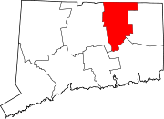
Mansfield Center, Connecticut — CDP — Coordinates: 41°45′59″N 72°11′41″W / 41.76639°N 72.19472°W Country United States State Connecticut County Tolland Area – Total 3.4 sq mi (8.8 km2) – Land 3.1 sq mi (7.9 km2) – Water 0.4 sq mi (0.9 km2) Elevation 256 ft (78 m) Population (2000) – Total 973 – Density 318.9/sq mi (123.1/km2) Time zone Eastern (EST) (UTC-5) – Summer (DST) EDT (UTC-4) ZIP code 06250 Area code(s) 860 FIPS code 09-45120 GNIS feature ID 0208699 Mansfield Center is a census-designated place (CDP) within the town of Mansfield in Tolland County, Connecticut, United States. The population was 973 at the 2000 census. The CDP includes the town center of Mansfield also sometimes known as Mansfield Village.
Contents
Geography
According to the United States Census Bureau, the CDP has a total area of 8.8 km² (3.4 mi²). 7.9 km² (3.0 mi²) of it is land and 0.9 km² (0.4 mi²) of it (10.56%) is water.
Demographics
As of the census[1] of 2000, there were 973 people, 373 households, and 239 families residing in the CDP. The population density was 123.2/km² (318.9/mi²). There were 382 housing units at an average density of 48.4/km² (125.2/mi²). The racial makeup of the CDP was 92.19% White, 1.23% African American, 0.21% Native American, 4.01% Asian, 0.10% Pacific Islander, 0.41% from other races, and 1.85% from two or more races. Hispanic or Latino of any race were 1.44% of the population.
There were 373 households out of which 25.7% had children under the age of 18 living with them, 55.2% were married couples living together, 6.2% had a female householder with no husband present, and 35.9% were non-families. 26.3% of all households were made up of individuals and 9.7% had someone living alone who was 65 years of age or older. The average household size was 2.38 and the average family size was 2.85.
In the CDP the population was spread out with 18.8% under the age of 18, 8.1% from 18 to 24, 23.8% from 25 to 44, 25.9% from 45 to 64, and 23.3% who were 65 years of age or older. The median age was 44 years. For every 100 females there were 87.5 males. For every 100 females age 18 and over, there were 85.4 males.
The median income for a household in the CDP was $53,125, and the median income for a family was $76,194. Males had a median income of $40,625 versus $29,886 for females. The per capita income for the CDP was $24,401. About 2.9% of families and 7.2% of the population were below the poverty line, including 12.7% of those under age 18 and none of those age 65 or over.
Historic features
Mansfield Center Cemetery, which contains many 18th-century gravestones, is listed on the National Register of Historic Places as a fine example of the rich artistic tradition of funerary stone carving in colonial New England.[2]
Historic buildings in Mansfield Center include the Barrows and Burnham Store, a general store built in 1886.[3]
Notable residents
- Peter Tork, musician and actor with The Monkees[citation needed]
References
- ^ "American FactFinder". United States Census Bureau. http://factfinder.census.gov. Retrieved 2008-01-31.
- ^ Bruce Clouette (February 26, 1992). "NRHP Inventory-Nomination: Mansfield Center Cemetery". National Park Service. http://pdfhost.focus.nps.gov/docs/NRHP/Text/92000905.pdf.
- ^ Two Historical Buildings Saved, Mansfield Historical Society website, accessed June 27, 2009 and archived August 21, 2008.
Further reading
- Historic Mansfield Center, Mansfield Historical Society, 2001
Municipalities and communities of Tolland County, Connecticut Towns Unincorporated
communitiesCoventry Lake | Crystal Lake | Hydeville | Mansfield Center | Mansfield Hollow | Rockville | Somersville | South Coventry | Stafford Hollow | Storrs | Talcottville
Coordinates: 41°45′55″N 72°11′53″W / 41.76528°N 72.19806°W
Categories:- Census-designated places in Tolland County, Connecticut
- Mansfield, Connecticut
- Villages in Connecticut
Wikimedia Foundation. 2010.

