- Massachusetts Route 146
-
Route 146

Route information Length: 20.9901 mi[1] (33.7803 km) Major junctions South end:  Route 146 in N. Smithfield, RI
 US 20 / I-90 (Mass Pike) in Millbury
North end:  Interstate 290 in Worcester
Highway system Massachusetts State Highway Routes
←  Route 145
Route 147  →
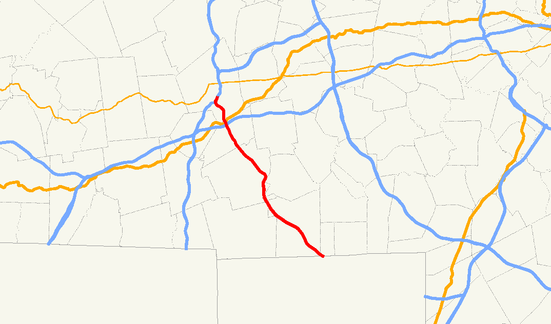
→Route 146 is a high-speed road, mostly freeway, linking Rhode Island Route 146 (the North Smithfield Expressway towards Providence, Rhode Island) to I-290 in Worcester, Massachusetts. South of the interchange with Route 122A, Route 146 is known as the Worcester-Providence Turnpike. Unlike some roads designated as turnpikes, the road has never had tolls, and was built on a brand new alignment in the 1930s. Similar never-tolled turnpikes are the Berlin Turnpike in Connecticut and the Boston-Providence Turnpike in Massachusetts.
Contents
History
During the late 1940's, the Massachusetts Department of Public Works (MassDPW) planned an extension of Route 146 from Rhode Island north toward Worcester. MA 146 was built between 1949 and 1952 as a four-lane divided roadway from US 20 in Millbury to Boston Road in Sutton and from Sutton south to the Massachusetts-Rhode Island border, Route 146 was built as a three-lane undivided roadway, providing one lane in each direction and a shared lane in the center.
In 1981 the MassDPW began work on rebuilding Route 146. During the next three years, the state rebuilt the 13.1-mile-long section from just south of Boston Road in Sutton to the Massachusetts-Rhode Island border, replacing the three-lane undivided section with a four-lane freeway and eliminating all at-grade intersections and curb cuts.
The project upgrading the section linking Exit 10A on the Massachusetts Turnpike north into downtown Worcester at Brosnihan Square to Interstate Highway standards was completed in November 2007 according to the State Highway Administration. The final construction phase will upgrade the remaining Massachusetts section in Sutton and Millbury to freeway status and is scheduled for completion sometime after 2010.[2]
Exit list
Exit numbers were traditionally not signed, but are now being signed. Also, they have been assigned by MassHighway.
County Location Mile Exit # Destinations Notes Worcester Millville 0.0  enters Massachusetts from Rhode Island
Uxbridge 1.1 1  Route 146A - South Uxbridge; North Smithfield, Rhode Island
2.6 2 TO Chockalog Road to Route 146A - Uxbridge and to  Route 98 to South Uxbridge and Burrillville, Rhode Island and its villages of Harrisville, Rhode Island and Pascoag.
5.3 3  Route 16 - Uxbridge; Douglas
7.6 4 Lackey Dam Road - East Douglas; Whitinsville; North Uxbridge Sutton 8.5 5 Main Street - Whitinsville; Manchaug 10.3 6 Purgatory Road - Northbridge; Whitinsville (to Purgatory Chasm State Reservation) 12.3 7 Central Turnpike - Northbridge; Oxford North end of freeway 13.8 Boston Road - Wilkinsonville, Sutton Center At-grade intersection with traffic signal Millbury 16.0 8 West Main Street - Millbury South end of freeway 16.9 9 
 Route 122A south - Millbury Center
Route 122A joins northbound and leaves southbound 16.9 joins 
17.9 10 I-90 - Mass Pike / US 20 - Boston; Springfieldvia Route 20 Connector Worcester 18.8 11 Millbury Street Northbound exit and southbound entrance 19.5 12 

Route 122A north, to I-290 west - McKeon Road; Vernon HillRoute 122A joins southbound and leaves northbound 19.5 leaves 20.5 13 
I-290 east - Shrewsbury; MarlboroNorthbound exit and southbound entrance 20.5 ends at 
Suffixed routes
Route 146A
Location: Uxbridge Length: 4.1 mi[3] (6.6 km) Existed: 1984[2]–present Route 146A in Massachusetts, United States, is a 4.1 mile north to south route which connects Route 122 in Uxbridge, and Rhode Island Route 146A in North Smithfield.[1] There are two connector entrances to Route 146, along Route 146A. These are Exit 1, which connects Route 146 directly to Route 146A, and Exit 2, the Chockalog Road exit in Uxbridge.[1] This highway was renamed by the General Court of Massachusetts in 2004 as the Lydia Taft Highway, after America's first woman voter, Lydia Chapin Taft, a colonial woman from Uxbridge. Lydia Chapin Taft's historic vote and her role in the history of Women's suffrage is recognized by the Massachusetts legislature since 2004, which named Route 146A from Uxbridge to the Rhode Island border in her honor.[4] Route 146A is completely within the town limits of Uxbridge.
In colonial times, this route had the name of "the Great Road", and later "the Quaker Highway", after Quakers from Smithfield, Rhode Island settled here. There are a number of historic sites along this road including the Friends Meetinghouse, which is on the National Historic Register. The "Moses Farnum House, and the Ironstone Mill Housing and Cellar Hole are two other sites along this road. Route 98 also connects with Route 146A, near its midpoint, and has significant historic sites of the original Quaker village known as Quaker City, and Aldrich Village, which are also on the National Historic Register. Just beyond the northern terminus of Route 146A and continuing north on Route 122 is a famous historical house known as Elmshade, a home and gathering place of the influential Taft family in America. Part of what is now Route 146A was the original Route 146 before a new limited access highway was constructed from the Rhode Island line to Worcester, between 1981 and 1984.[2] This project involved moving a former almshouse cemetery and led to archeological findings on mortuary practices following that excavation.[2] The Second Great Awakening changed local mortuary practices for the poor.[5]
References
- ^ a b c Executive Office of Transportation, Office of Transportation Planning - 2005 Road Inventory
- ^ a b c d "146, Worcester Providence Turnpike". Boston Roads.com. http://www.bostonroads.com/roads/MA-146/. Retrieved 2008-01-14.
- ^ Rand McNally Mileage Calc, 1 Quaker Highway, Uxbridge, MA to 1099 quaker Highway, Uxbridge, MA (state line)
- ^ ""AN ACT DESIGNATING STATE HIGHWAY ROUTE 146A IN THE TOWN OF UXBRIDGE AS THE LYDIA TAFT HIGHWAY"; "Chapter 56 of the Acts of 2004"". Massachusetts State Government; the state legislature;. http://www.mass.gov/legis/laws/seslaw04/sl040056.htm. Retrieved 2007-09-29.
- ^ ""The Historical Archeology of Mortuary Behavior: Coffin Hardware from Uxbridge, Massachusetts; Abstract: Edward Bell"" (PDF). University of Florida. 1992. http://www.clas.ufl.edu/users/davidson/Arch%20of%20Death/Week%2013/Bell%201990.pdf. Retrieved 2007-11-01.
Freeways in the Providence metropolitan area Interstate highways Other freeways Unbuilt freeways See also Categories:- Numbered routes in Massachusetts
- Transportation in Worcester, Massachusetts

Wikimedia Foundation. 2010.