- Curridabat Canton
-
Curridabat — Canton — Plaza del Sol commercial center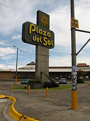

Coat of armsNickname(s): Curri Curridabat canton in San José province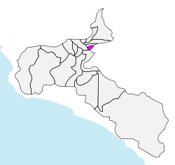
Coordinates: 09°56′N 84°05′W / 9.933°N 84.083°WCoordinates: 09°56′N 84°05′W / 9.933°N 84.083°W Country Costa Rica Province San José Established August 21, 1929 Districts 4 districts (distritos)- Curridabat
- Granadilla
- Sánchez
- Tirrases
Government - Mayor[1] Édgar Mora Altamirano (2010-2016) (Partido Curridabat Siglo XXI) Area - Total 15.95 km2 (6.2 sq mi) Elevation 1,208 m (3,963 ft) Population (2010)[2] - Total 72,564 - Density 4,549.5/km2 (11,783.1/sq mi) Time zone Central Standard Time (UTC-6) Website www.curridabat.go.cr Curridabat is the name of the 18th canton in the province of San José in Costa Rica. The canton covers an area of 15.95 square kilometres (6.16 sq mi),[3] and has a population of 72,564 (estimate as of 2010).[4] The capital city of the canton is also called Curridabat.
The canton forms a suburb of the national capital of San José, lying on the southeast edge of the city.
Contents
Districts
The canton of Curridabat is subdivided into four districts (distritos):[5]
District Postal code Alt. (m) Area (km2) Pop. (2008) Coordinates Curridabat 11801 1,208 6.48 34,073 09°54′58″N 84°02′22″W / 9.91611°N 84.03944°W Barrios (neighborhoods): Ahogados (part), Aromático, Cipreses, Chapultepec, Dorados, Guayabos, Hacienda Vieja, Hogar, José María Zeledón, Laguna, La Lía, Mallorca, María Auxiliadora, Miramontes, Nopalera, Plaza del Sol, Prado, San José, Santa Cecilia, Tacaco Granadilla 11802 1,343 3.41 13,214 09°56′11″N 84°00′53″W / 9.93639°N 84.01472°W Barrios (neighborhoods): Biarquiria, Eucalipto, Freses, Granadilla Norte, Granadilla Sur, Montaña Rusa (part) Sánchez 11803 1,250 4.17 3,470 09°54′47″N 84°01′06″W / 9.91306°N 84.01833°W Barrios (neighborhoods): Araucauria (part), Lomas de Ayarco, Pinares Tirrases 11804 1,175 1.89 18,717 09°54′27″N 84°02′22″W / 9.9075°N 84.03944°W Barrios (neighborhoods): Colina, Lomas de San Pancracio, Ponderosa, Quince de Agosto History
The canton was established by law on August 21, 1929.
In 1930 the canton had a municipality with three regidores, a Major (AKA Ejecutivo Municipal) and Jefe político (both charges were in the same person). At this time the canton's population were 5,000 people, but with the time and the population grew and the municipality had to create a sanitation department to collect garbage, road, sidewalk maintenance and built some infrastructure. Then the municipality Council was expanded to five members by popular election in 1970.
Points of interest
- Plaza del Sol, a mall built in the 1980s as the most modern mall in the country. Today, it has many customers ranging from middle to high class.
- Multiplaza del Este, a new mall that belongs to the commercial chain with the same name and have other malls in Central America. It has food court, cinemas and stores.
- San José Indoor Club Club Campestre, it is for the middle and high class people in San José.
Notable residents
- Rafael Ángel Calderón Fournier, former president, lives in Pinares; also son of former president Rafael Ángel Calderón Guardia
- Karen Olsen Beck, wife of former president José Figueres Ferrer; also mother of former president José Figueres Olsen
References
- ^ "Lista de alcaldes electos 2010 - 2016 en los comicios municipales [List of mayors elected 2010 - 2016 in the municipal elections]" (in Spanish). El País. 06/12/2010. http://www.elpais.cr/articulos.php?id=37619.
- ^ "Curridabat, San José" (in Spanish) (PDF). Instituto de Formacion y Estudios en Democracia. http://www.tse.go.cr/tseficha/datos/curridabat.pdf.
- ^ Instituto Geográfico Nacional (IGN), 2001.
- ^ Estimates of Instituto Nacional de Estadística y Censos (INEC), 2010.
- ^ "División Territorial Administrativa de Costa Rica" (in Spanish) (PDF). Instituto de Fomento y Asesoria Municipal (IFAM). 5 May 2009. http://www.ifam.go.cr/PaginaIFAM/ifams/Descargas/CDI/Legal/Divisi%C3%B3n%20Territorial%20CR%20%20Publicado%20en%20La%20Gaceta%2026%20mayo%202009.pdf.
External links
- Curridabat, official site
 Cantons of San José Province
San José · Escazú · Desamparados · Puriscal · Tarrazú · Aserrí · Mora · Goicoechea · Santa Ana · Alajuelita · Coronado · Acosta · Tibás · Moravia · Montes de Oca · Turrubares · Dota · Curridabat · Pérez Zeledón · León Cortés
Categories:


Wikimedia Foundation. 2010.