- Miami Springs, Florida
-
City of Miami Springs, Florida — City — 
SealNickname(s): Tree City, USA Motto: At the Heart of It All Location in Miami-Dade County and the state of Florida U.S. Census Bureau map showing city limits
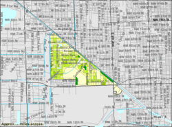
Coordinates: 25°49′11″N 80°17′28″W / 25.81972°N 80.29111°WCoordinates: 25°49′11″N 80°17′28″W / 25.81972°N 80.29111°W Country  United States
State  Florida
County Miami-Dade Incorporated 1926 Government - Mayor Zavier Garcia Area - City 3.0 sq mi (7.7 km2) - Land 2.9 sq mi (7.6 km2) - Water 0.04 sq mi (0.1 km2) Elevation 33 ft (2 m) Population (2007) - City 12,631 - Density 4,666.8/sq mi (1,800/km2) - Metro 5,422,200 Time zone EST (UTC-5) - Summer (DST) EDT (UTC-4) ZIP codes 33166, 33266 Area code(s) 305 FIPS code 12-45200[1] GNIS feature ID 0286762[2] Website http://www.miamisprings-fl.gov Miami Springs is a Miami suburban city located in Miami-Dade County, Florida. The city was founded by Glenn Hammond Curtiss, "The Father of Naval Aviation", and James Bright, during the famous "land boom" of the 1920s and was originally named Country Club Estates. It, along with other Miami suburbs such as Coral Gables, Florida and Opa-locka, Florida, formed some of the first planned communities in the state. Like its counterparts, the city had an intended theme which in its case, was to reflect a particular architecture and ambiance.
In this case it was a regional style of architecture called Pueblo Revival developed in the southwest, primarily New Mexico, and incorporating design elements of Pueblo architecture. Other buildings incorporated Mission style design. In fact, the original Hotel Country Club was designed to resemble a Pueblo village.[3]
Shortly prior to incorporation in 1926, the city was renamed after a spring located in the area which provided parts of Miami with fresh water until the mid-1990s. As of 2007, the population recorded by the U.S. Census Bureau is 12,631.[4]
Contents
Geography
Miami Springs is located at 25°49′11″N 80°17′28″W / 25.819725°N 80.291071°W.[5]
According to the United States Census Bureau, the city has a total area of 3.0 square miles (7.8 km2). 2.9 square miles (7.5 km2) of it is land and 0.04 square miles (0.10 km2) of it (1.34%) is water.
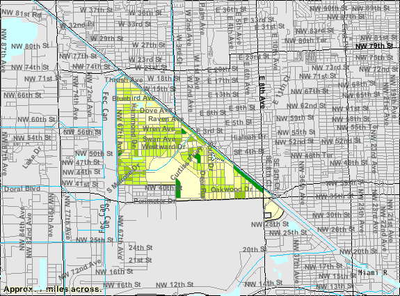
Roughly speaking the core of Miami Springs (excluding the more recently annexed areas) is roughly shaped as a triangle with three definable sides. Northwest 36th Street forms most of the southern boundary whilst the Miami River canal forms the northern/eastern boundary. Finally, the Ludlam Canal and Florida East Coast Railroad Yard delimit the western boundary.
Surrounding areas
- Hialeah
- Medley


 Miami
Miami - Unincorporated Miami-Dade County, Virginia Gardens

 Hialeah, Miami, Unincorporated Miami-Dade County
 - Unincorporated Miami-Dade County


 Unincorporated Miami-Dade County
 - Virginia Gardens, Unincorporated Miami-Dade County
Demographics
As of the census[1] of 2000, there were 13,712 people, 5,090 households, and 3,517 families residing in the city. The population density was 4,666.8 inhabitants per square mile (1,800.8/km2). There were 5,286 housing units at an average density of 1,799.0 per square mile (694.2/km2). The racial makeup of the city was 90.81% White (37% were Non-Hispanic White,).[6] 2.04% African American, 0.22% Native American, 1.19% Asian, 0.04% Pacific Islander, 3.04% from other races, and 2.66% from two or more races. Hispanic or Latino of any race were 59.60% of the population.
In The Birds Section: 95.22% White (46.1% were Non-Hispanic White,).[6] 0.41% African American, 0.62% Native American, 0.84% Asian, 0.12% Pacific Islander, 1.78% from other races, and 1.30% from two or more races. Hispanic or Latino of any race were 49.12% of the population.
There were 5,090 households out of which 33.6% had children under the age of 18 living with them, 52.0% were married couples living together, 12.2% had a female householder with no husband present, and 30.9% were non-families. 24.8% of all households were made up of individuals and 8.2% had someone living alone who was 65 years of age or older. The average household size was 2.64 and the average family size was 3.16.
In the city the population was spread out with 22.9% under the age of 18, 7.2% from 18 to 24, 31.2% from 25 to 44, 23.2% from 45 to 64, and 15.5% who were 65 years of age or older. The median age was 39 years. For every 100 females there were 92.5 males. For every 100 females age 18 and over, there were 88.6 males.
The median income for a household in the city was $50,000, and the median income for a family was $56,892. Males had a median income of $37,176 versus $30,823 for females. The per capita income for the city was $22,963. About 6.9% of families and 9.7% of the population were below the poverty line, including 9.8% of those under age 18 and 8.6% of those age 65 or over.
As of 2000, speakers of Spanish as a first language made up 63.21% of residents, while English accounted for 35.48% of the population. Other languages spoken as a mother tongue were well below 1% of residents.[7]
As of 2000, Miami Springs had the sixteenth highest percentage of Cuban residents in the US, with 31.83% of the populace.[8] It had the thirty-third highest percentage of Colombian residents in the US, at 3.89% of the city's population,[9] and the twenty-second highest percentage of Nicaraguan residents in the US, at 2.06% of the its population.[10] It also had the twenty-sixth most Peruvians in the US, at 1.9%,[11] while it had the nineteenth highest percentage of Venezuelans, at 1.01% of all residents.[12]
History
Miami Springs was founded by an aviation pioneer, and thus, the fate of the city has always been intertwined with the aviation industry, particularly since Miami International Airport (MIA) is located just south of the city on the southern border of NW 36th Street. The airline industry brought many residents from airline crew bases, as well as employment opportunities at the airport, which brought much prosperity to the city. This dependence, however, left the city vulnerable. The sudden 1991 collapses of both Eastern Airlines and Pan American World Airways left many Miami Springs residents unemployed and unable to afford living in the neighborhood. Given that the businesses in Miami Springs had always relied upon the large disposable incomes of the employees of the large airline carriers, the bankruptcy of both corporations in the same year created a chain reaction, eventually causing many small businesses to close their doors. Despite the closure of the airlines, from a residential standpoint, Miami Springs remained strong. The city is often seen as blessedly isolated from the perceived turbulence of the rest of Miami-Dade County. This has continued to provide ample replacements for the older residents who are lost over time. Nonetheless the legacy of the airline closures remains. Residential mileage taxation rates hover near the state mandated maximum because continued weakness in the commercial sector makes it an insufficient source of tax revenue.
Economy
The Consulate-General of Bolivia in Miami is located in Suite 505 at 700 South Royal Poinciana Boulevard in Miami Springs.[13]
Significant Historical Landmarks
Curtiss Mansion is a Pueblo style home that belonged to city founder Glenn Curtiss. After suffering the ravages of two fires in which arson was suspected, it was little more than a burned out shell. The outside of the Curtiss Mansion has been restored through the tireless efforts of the Curtiss Mansion Board, which consists of local activists and celebrated architects.
Fair Haven Nursing Home is one of the oldest buildings in Miami Springs and is built in the pueblo style favored during the initial development. Before becoming a nursing home, the building served as a hotel and at another point as a sanitarium in accordance with the beliefs of John Harvey Kellogg.
Education
The city of Miami Springs is served by a sizeable number of public and private educational institutions. The city is part of the Miami-Dade County Public Schools System (M-DCPS), and all public schools under this system follow guidelines set forth by the Florida Department of Education. Miami Springs is served publicly by:
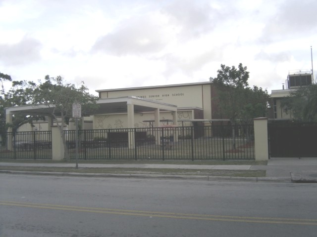
- Miami Springs Senior High School
- Miami Springs Middle School
- Miami Springs Elementary School
- Springview Elementary School.
Private education in Miami Springs is largely provided by local religious institutions. Blessed Trinity Catholic School[14] is located in nearby Virginia Gardens, Florida, and provides K-8 education. All Angels Episcopal Church operates All Angels Academy[15] for children of a similar age group, as does Grace Lutheran Church with its Grace Lutheran Learning Center.[16] High School aged children who do not wish to attend public school may seek secondary education outside of Miami Springs. Additionally a number of private daycare centers serve as education providers for pre-school students. Of note in this respect is the New Beavers Kiddie Kollege[17] which has been in operation for well over a decade in the same location.
References
- ^ a b "American FactFinder". United States Census Bureau. http://factfinder.census.gov. Retrieved 2008-01-31.
- ^ "US Board on Geographic Names". United States Geological Survey. 2007-10-25. http://geonames.usgs.gov. Retrieved 2008-01-31.
- ^ Source: Escape from the Southwest: The Pueblo Style in Minnesota and Florida by Carl D. Sheppard and Stephen D. Schreiber in Pueblo Style and Regional Architecture; Nicholas C. Markovich, Wolfgang F.E. Preiser, and Fred Sturm (Eds.)
- ^ http://www.census.gov/popest/cities/tables/SUB-EST2004-04-12.xls
- ^ "US Gazetteer files: 2010, 2000, and 1990". United States Census Bureau. 2011-02-12. http://www.census.gov/geo/www/gazetteer/gazette.html. Retrieved 2011-04-23.
- ^ a b "Demographics of Miami Springs, FL". MuniNetGuide.com. http://www.muninetguide.com/states/florida/municipality/Miami_Springs.php. Retrieved 2007-10-31.
- ^ "MLA Data Center Results of Miami Springs, FL". Modern Language Association. http://www.mla.org/map_data_results&state_id=12&county_id=&mode=place&zip=&place_id=45200&cty_id=&ll=&a=&ea=&order=r. Retrieved 2007-10-31.
- ^ "Ancestry Map of Cuban Communities". Epodunk.com. http://www.epodunk.com/ancestry/Cuban.html. Retrieved 2007-10-31.
- ^ "Ancestry Map of Colombian Communities". Epodunk.com. http://www.epodunk.com/ancestry/Colombian.html. Retrieved 2007-10-31.
- ^ "Ancestry Map of Nicaraguan Communities". Epodunk.com. http://www.epodunk.com/ancestry/Nicaraguan.html. Retrieved 2007-10-31.
- ^ "Ancestry Map of Peruvian Communities". Epodunk.com. http://www.epodunk.com/ancestry/Peruvian.html. Retrieved 2007-10-31.
- ^ "Ancestry Map of Venezuelan Communities". Epodunk.com. http://www.epodunk.com/ancestry/Venezuelan.html. Retrieved 2007-10-31.
- ^ "Servicios Consulares." Embassy of Bolivia in the United States. Retrieved on January 30, 2009.
- ^ Blessed Trinity - Home
- ^ AllAngelsAcademy.org | Home
- ^ Grace Lutheran Learning Center - Miami Springs, Florida - FL - school overview
- ^ New Beavers Kiddie Kollege - Miami Springs, Florida - FL - school overview
External links
- City of Miami Springs
- Miamisprings.com unofficial site
Categories:- Cities in Miami-Dade County, Florida
- Populated places in Florida with Hispanic majority populations
- Planned cities in the United States


Wikimedia Foundation. 2010.