- Fort Monroe
Infobox_nrhp | name =Fort Monroe
nrhp_type =nhl
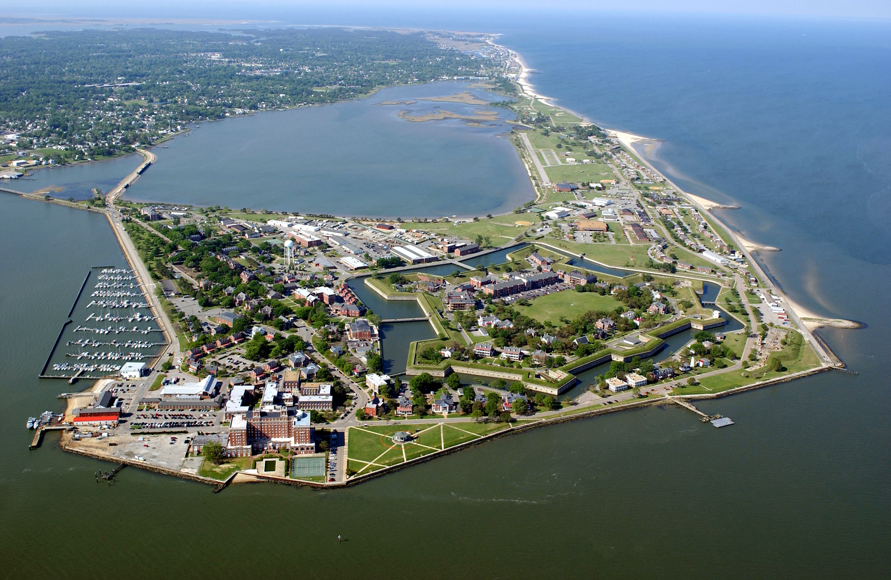
caption =Fort Monroe Aerial Photo 2004
location=Hampton, Virginia
area =
built =1819
designated=December 19 ,1960 cite web|url=http://tps.cr.nps.gov/nhl/detail.cfm?ResourceId=691&ResourceType=District
title=Fort Monroe |accessdate=2008-06-23|work=National Historic Landmark summary listing|publisher=National Park Service]
added =October 15 ,1966
governing_body =United States Army
refnum=66000912 cite web|url=http://www.nr.nps.gov/|title=National Register Information System|date=2007-01-23|work=National Register of Historic Places|publisher=National Park Service] Fort Monroe (also known as Fortress Monroe) is aHampton, Virginia , military installation located atOld Point Comfort , which is on the tip of theVirginia Peninsula . Along with Fort Calhoun, later renamedFort Wool , it guarded approach by sea of the navigational shipping channel between theChesapeake Bay and the entrance to the harbor ofHampton Roads , which itself is formed by the confluence of the Elizabeth River, theNansemond River , and the James River, the longest in Virginia.During the initial exploration by the mission headed by Captain
Christopher Newport in the earliest days of theColony of Virginia , the site was identified as a strategic defensive location. In May of 1607, they established the first permanent English settlement in the present-day United States about 25 miles further inland from the Bay along the James River at Jamestown. The land area where Fort Monroe is located became part of Elizabeth Cittie [sic] in 1619,Elizabeth River Shire in 1634, and was included in Elizabeth City County when it was formed in 1643. Over 300 years later, in 1952, Elizabeth City County and Fort Monroe's neighbor, the nearby Town of Phoebus, agreed to consolidate with the smallerindependent city of Hampton, which became one of the largeSeven Cities of Hampton Roads .Beginning by 1609, fortifications had been established at Old Point Comfort during Virginia's first two centuries. However, the much more substantial facility of stone to become known as Fort Monroe (and adjacent Fort Wool on a man-made island across the channel) were completed in 1834. The principal facility was named in honor of U.S. President
James Monroe . Throughout theAmerican Civil War (1861-1865), although most of Virginia became part of theConfederate States of America , Fort Monroe remained in Union hands. It became notable as a historic and symbolic site of early freedom for former slaves under the provisions of contraband policies and later theEmancipation Proclamation . For several years thereafter, the former Confederate President,Jefferson Davis , was imprisoned in the area now known as the Casemate Museum on the base.Completely surrounded by a
moat , the six-sided stone fort is the only one of its kind left in theUnited States that is still an active Army post. Fort Monroe is one of several posts selected to be closed by September 2011. Many of its functions are being transferred to nearbyFort Eustis (which itself was named for Fort Monroe's first commander, GeneralAbraham Eustis , a notedartillery expert). Several re-use plans for Fort Monroe after it is decommissioned are currently under development in the Hampton community.History
Colonial Period
Arriving with three ships under Captain
Christopher Newport , Captain John Smith and the colonists of theVirginia Company who established theJamestown Settlement of the BritishColony of Virginia on the James River in 1607. On their initial exploration, they recognized the strategic importance of the site atOld Point Comfort for purposes of coastal defense. They initially built Fort Algernourne (1609-1612) at the location of the present Fort Monroe. It is assumed to have been a triangular stockade, based on the fort at Jamestown. Fort Algernoure burned in 1612. A second fort, known only as "the fort at Old Point Comfort" was constructed in 1632 and destroyed by a hurricane in 1667. In 1728, Fort George was built on the site. Its masonry walls were destroyed by a hurricane in 1749, but the wood buildings within the fort continued to be used by a reduced force until at least 1775. In 1781, during the siege of Yorktown, the French West Indian fleet established a battery on the ruins of Fort George. Throughout the Colonial period, fortifications were manned at the location from time to time.Early 19th century
Following the
War of 1812 , the United States again came to realize the importance of protecting Hampton Roads and the inland waters from attack by sea, and construction was begun in 1819 on what would become the largest stone fort ever built in the United States. The fort, designed bySimon Bernard , features a moat completely surrounding the inner structures. As a young first lieutenant and engineer in the U.S. Army,Robert E. Lee was stationed there from 1831 to 1834, and played a major role in the final construction of both Fort Monroe and its opposite, Fort Calhoun. The latter, later renamedFort Wool , was built on aman-made island called theRip Raps across the navigational channel fromOld Point Comfort in the middle of the mouth ofHampton Roads . The fort was briefly used to detainBlack Hawk .When construction was completed in 1834, Fort Monroe was referred to as the "Gibraltar of Chesapeake Bay." The fort accomplished this mission by mounting an impressive complement of the most powerful artillery of the time, 32-pounder guns with a range of over one mile. In conjunction with Fort Calhoun (later Fort Wool), this was just enough range to cover the main shipping channel into the area. (Decommissioned after
World War II , the former Fort Wool on Rip Raps is now adjacent to the southern man-made island of theHampton Roads Bridge-Tunnel , initially completed in 1957).American Civil War
1860–61
Fort Monroe played an important role in the
American Civil War . OnDecember 20 ,1860 ,South Carolina became the first state to secede from the Union. Four months later, onApril 12 ,1861 , troops of that state opened fire onFort Sumter in Charleston Harbor. Five days later,Virginia became the eighth Southern state to withdraw from the Union, and join the newly formedConfederate States of America .President
Abraham Lincoln had Fort Monroe quickly reinforced so that it would not fall to Confederate forces. It was held by Union forces throughout the Civil War and several sea and land expeditions were launched from there by Union forces.A few weeks after the
Battle of Fort Sumter in 1861, U.S. Army General-in-ChiefWinfield Scott proposed to PresidentAbraham Lincoln a plan to bring the states back into the Union: cut the Confederacy off from the rest of the world instead of attacking its army in Virginia. His plan was to blockade the Confederacy's coastline and control theMississippi River valley with gunboats. In cooperation with the Navy, troops from Fort Monroe extended Union control along the coasts ofthe Carolinas as Lincoln ordered a blockade of the Southern seaboard from the South Carolina line to theRio Grande onApril 19 , and onApril 27 extended it to include theNorth Carolina and Virginia coasts.On
April 20 the Union Navy burned and evacuated theNorfolk Navy Yard , destroying nine ships in the process, leaving only Fort Monroe atOld Point Comfort as the last bastion of the United States in Tidewater Virginia. Occupation of Norfolk gave the Confederacy its only major shipyard and thousands of heavy guns, but they held it for only one year. Confederate Brigadier GeneralWalter Gwynn , who commanded the Confederate defenses around Norfolk, erected batteries atSewell's Point , both to protect Norfolk and to controlHampton Roads .The Union dispatched a fleet to Hampton Roads to enforce the blockade, and on May 18–19, 1861, Federal gunboats based at Fort Monroe exchanged fire with the Confederate batteries at Sewell's Point. The little-known
Battle of Sewell's Point resulted in little damage to either side. Several land operations against Confederate forces also were mounted from the fort, notably theBattle of Big Bethel in June 1861.Fort Monroe is also the place at which, on
May 27 ,1861 , Major General Benjamin Butler made his famous "contraband " decision, by which escaping slaves reaching Union lines would not be returned to bondage. The order resulted in waves of enslaved people fleeing to Union lines around Fort Monroe, which was Butler's headquarters in Virginia, and earned Fort Monroe its other nickname of "Freedom's Fortress", as any slave reaching it would be free.Under Gen. Butler's command, Fort Monroe was the site of a military
balloon camp under the flight direction of aeronaut John LaMountain. While theUnion Army Balloon Corps was being developed at Fort Corcoran near Arlington under the presidentially appointed Prof.Thaddeus S. C. Lowe , LaMountain, who was also vying for position as Chief Aeronaut, had gained the confidence of Butler in using his balloon "Atlantic" for aerial observations. LaMountain is accredited with having made the first successful report from an aerial station that was of practical military intelligence. LaMountain was later reassigned to Lowe's balloon corps, but after a period of in-fighting with Lowe he was released from military service. Lowe would eventually assign regular military balloons to Fort Monroe.1862
In March 1862, the naval
Battle of Hampton Roads took place off Sewell's Point between the first ironclad warships, CSS "Virginia" and USS "Monitor". While the outcome was inconclusive, the battle marked a change in naval warfare and the end to wooden fighting ships.Later that spring, the continuing presence of the Union Navy based at Fort Monroe enabled Federal water transports from Washington, D.C., to land unmolested to support Major General
George B. McClellan 'sPeninsula Campaign . Formed at Fort Monroe, McClellan's troops moved up theVirginia Peninsula during the spring of 1862, reaching within a few miles of the gates of Richmond about 80 miles to the west by June 1. For the next 30 days, they laid siege to Richmond. Then, during theSeven Days Battles , McClellan fell back to the James River well below Richmond, ending the campaign. Fortunately for McClellan, during this time, Union troops regained control of Norfolk, Hampton Roads, and the James River belowDrewry's Bluff (a strategic point about 8 miles south of Richmond).1864–96
In 1864, the Union
Army of the James under Major General Benjamin Butler was formed at Fort Monroe. The2nd Regiment, United States Colored Cavalry , mustered at Fort Monroe on December 22, 1864, and The1st Regiment, United States Colored Cavalry mustered the same day at nearby Camp Hamilton. TheSiege of Petersburg during 1864 and 1865 was supported on the James River from a base at City Point (nowHopewell, Virginia ). Maintaining the control of Hampton Roads at Fort Monroe and Fort Wool was crucial to the naval support Grant required for the successful Union campaign to take Petersburg, which was the key to the fall of the Confederate capitol at Richmond. As Petersburg fell, Richmond was evacuated in 1865 on the night of April 2–3. That night, Confederate PresidentJefferson Davis and his cabinet escaped Richmond, taking theRichmond and Danville Railroad to move first to Danville and thenNorth Carolina . However, the cause was lost, and Confederate GeneralRobert E. Lee surrendered what was left of theArmy of Northern Virginia to Grant at Appomattox Court House the following week.After the last Confederate cabinet meeting was held on
April 26 ,1865 , atCharlotte, North Carolina , Jefferson Davis was captured atIrwinville , Georgia, and placed under arrest. He was confined in an unheated, opencasemate at Fort Monroe for two years. Some historians have speculated that his treatment in captivity was intended to be lethal. In poor health, Davis was released in May, 1867, on bail, which was posted by prominent citizens of both Northern and Southern states, includingHorace Greeley andCornelius Vanderbilt , who had become convinced he was being treated unfairly. The federal government proceeded no further in its prosecution due to the constitutional concerns ofU.S. Supreme Court Chief JusticeSalmon P. Chase .The "
Journal of the United States Artillery " was founded at Fort Monroe in 1892 by First Lieutenant (later General) John Wilson Ruckman and four other officers of the Artillery School. Ruckman served as the editor of the "Journal" for four years (July 1892 to January 1896) and published several articles therein afterward. One publication by West Point notes Ruckman's “guidance” and “first-rate quality” work were obvious as the "Journal" “rose to high rank among the service papers of the world.” The "Journal" was renamed the "Coast Artillery Journal" in 1922 and the "Antiaircraft Journal" in 1948.Twentieth century
Over time the armament at Fort Monroe was improved, taking advantage of new technologies. In addition, the fort controlled several sub installations around Hampton Roads, making the area one of the most heavily defended in the United States.
The
Jamestown Exposition held in 1907 atHampton Roads , featured an extensivenaval review , including theGreat White Fleet . Beginning in 1917, the former exposition site atSewell's Point became a major base of theUnited States Navy . Currently, Norfolk Navy Base is the base supporting naval forces operating in theAtlantic Ocean ,Mediterranean Sea , andIndian Ocean . It is the world's largest naval station based on supported military population.Fort Monroe and Fort Wool stood guard during
World War I andWorld War II , and successfully protected Hampton Roads and the important military and civilian resources located inland.By World War II, Fort Monroe served as headquarters for an impressive array of coast artillery guns ranging from 3-inch rapid fire guns to 16-inch guns capable of firing a 2,000 pound projectile 25 miles. In addition, the Army controlled submarine barriers and underwater mine fields. But this vast array of armaments was all made obsolete after the second World War by the development of the long-range bomber and the aircraft carrier .
After the operational armament was removed, Fort Monroe received a mission that it still maintains to this day. Since World War II, it has served as the major headquarters for training soldiers for war. In 1973, Fort Monroe became home to the
United States Army Training and Doctrine Command (TRADOC), which combines the recruitment, training and education of soldiers with the development of operational doctrine.Fort Monroe today
Fort Monroe supports a daytime population of about 2,096, including 1,105 people in uniform, 1,991 civilian and contract employees, and about 814 family members residing on post. The major tenant unit is the
United States Army Training and Doctrine Command (TRADOC).In addition to continuing to serve as an active military installation, Fort Monroe has become a popular historical site. The Casemate Museum, opened in 1951, depicts the history of Fort Monroe and Old Point Comfort, with special emphasis on the Civil War period. It offers a view of Confederate President
Jefferson Davis ' prison cell. Also shown are the quarters occupied by 1st Lt.Robert E. Lee in 1831-34, and the quarters where PresidentAbraham Lincoln was a guest in May, 1862.Fort Monroe is the scene of many running events, including for many years, the Shamrock Sportsfest Marathon.
Nearby, Fort Monroe's companion guardian of Hampton Roads,
Fort Wool , located atRip Raps is also available for tours."Note: Fort Wool is located adjacent to one of the man-made islands of the
Hampton Roads Bridge-Tunnel and is accessible only by water. The availability of public tours of both Fort Wool and Fort Monroe are subject toHomeland Security Alert conditions."Base Realignment and Closure, 2005
The Department of Defense released a list on
13 May ,2005 , of military installations recommended for closure and/or realignment--among them is Fort Monroe. The list was approved by PresidentGeorge W. Bush on15 September ,2005 , and submitted to Congress. Congress failed to act within forty-five legislative days to disapprove the list in its entirety, and the BRAC recommendations subsequently became law. Installations on the BRAC list must close within six years.Redevelopment possibilities
It is unclear as to what will become of the post after closing. Generally, surplus military installations are turned over to the respective states. Redevelopment will be facilitated by the fact that most of the land on which the fort stands was loaned by the state of Virginia to the federal government, and will revert to the state once Fort Monroe closes.
Virginia historically has given local government strong consideration in determining disposition at that point, such as occurred at
Fort Pickett in Nottoway County (near Blackstone) in the Southside region. Given the historic significance of the post, the decommissioned fort will be a good candidate for portions to become one of the preserved historical sites located throughout the greaterHampton Roads area. Redevelopment to help offset the economic loss of a base closure is usually a priority as well.The City of Hampton has recently received numerous unsolicited proposals for high-end residential and commercial development on the site once Fort Monroe is decommissioned. Because of the scarcity and desirability of waterfront property, the fort area is prime development property. The historic
Chamberlin Hotel , for example, has already been sold to a developer and is being renovated as retirement apartments.There are several groups competing for control of the site. The Citizens for a Fort Monroe National Park [http://www.cfmnp.org] are advocating turning the
National Historic Landmark site over to theNational Park Service to ensure its historic preservation. Several public meetings have been held, with no clear plan as to which faction will or should control of the Gibraltar of the Chesapeake.[http://home.hamptonroads.com/stories/story.cfm?story=86444&ran=176057] [http://home.hamptonroads.com/stories/story.cfm?story=86503&ran=129504]
Trivia
*A man-made island across the navigational channel of the mouth of
Hampton Roads fromOld Point Comfort was created for Fort Calhoun (a portion of the Fort Monroe complex later renamedFort Wool ). This man-made island found a new purpose in 1957, when it was used to anchor the south portal of the 7,000 foot tunnel of theHampton Roads Bridge-Tunnel .
* The quarters occupied by Robert E. Lee while stationed at Fort Monroe are still in use as military family housing.ee also
*
Fort Wool
*Sewell's Point
*Battle of Hampton Roads
*United States Army Training and Doctrine Command References
External links
* [http://fort.monroe.army.mil/monroe/sites/local/ Fort Monroe official website]
* [http://hdl.loc.gov/loc.pnp/hhh.va1665 Fort Monroe, Fortress, Hampton, VA: 57 b&w photos, 1 color photo] , atHistoric American Building Survey * [http://www.globalsecurity.org/military/facility/fort-monroe.htm GlobalSecurity.org Fort Monroe webpage]
* [http://www.tradoc.army.mil/museum/ Fort Monroe Casemate Museum]
* [http://www.tradoc.army.mil/index.html TRADOC website]
* [http://www.defenselink.mil/ U.S. Department of Defense website]
* [http://www.cfmnp.org/ Site for Citizens for a Fort Monroe National Park (CFMNP.org)]
* [http://www.civilwararchive.com/Unreghst/uncolcav.htm 2nd Regiment, United States Colored Cavalry]
* [http://www.civilwararchive.com/Unreghst/uncolcav.htm 1st Regiment, United States Colored Cavalry]
* [http://memory.loc.gov/cgi-bin/query/I?cwar:1:./temp/~ammem_QKDe::displayType=1:m856sd=cwpb:m856sf=03816:@@@cwa Photograph from the Library of Congress collection]
* [http://colorado.journey.googlepages.com/FortMonroe.kml Google Earth KML File]
Wikimedia Foundation. 2010.