- Cheshire West and Chester
-
"Cheshire West" redirects here. For the former European Parliament constituency, see Cheshire West (European Parliament constituency).
Coordinates: 53°12′47″N 2°54′07″W / 53.213°N 2.902°W
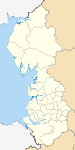
Cheshire West and Chester 

Shown with EnglandGeography Status Unitary Authority; Borough Origin 2009 structural changes Region North West England Area
- TotalRanked 32nd
918.28 km2 (354.55 sq mi)Admin HQ Chester ISO 3166-2 GB-CHW ONS code 00EW NUTS 3 UKD22 Demography Population
- Total (2010 est.)
- DensityRanked 16th
327,300
357 /km2 (920 /sq mi)Ethnicity 98.5% White Politics Cheshire West and Chester Council
http://www.cheshirewestandchester.gov.uk/Executive Conservative Members of Parliament - Andrew Miller (Lab)
- Stephen O'Brien (Con)
- Stephen Mosley (Con)
- Graham Evans (Con)
- George Osborne (Con)
Districts Cheshire West and Chester[1][2][3] is a unitary authority area with borough status,[4] in the ceremonial county of Cheshire. It was established in April 2009 as part of the 2009 structural changes to local government in England, by virtue of an order under the Local Government and Public Involvement in Health Act 2007.[5] It replaced the boroughs of Ellesmere Port and Neston, Vale Royal and Chester District and part of the former Cheshire County Council, which was disaggregated between the two new unitary Authorities of Cheshire East and Cheshire West & Chester. The rest of ceremonial Cheshire is composed of Cheshire East, Warrington and Halton. The decision to create the Cheshire West and Chester unitary authority was announced on 25 July 2007 following a consultation period, in which a proposal to create a single Cheshire unitary authority was rejected.[6] Chester City Council had proposed the new authority be called "The City of Chester and West Cheshire" but this was also rejected.[7]
Contents
Politics and administration
The electoral wards for the new unitary authority were the same as those used in the former Cheshire County Council elections, with each ward electing 3 councillors.[8] The first elections to the authority took place on 1 May 2008,[9] with the Conservatives gaining control with a majority of 38 councillors.[10] When first contested there were 72 elected councillors in the authority led by Councillor Mike Jones.
Due to boundary changes put into effect prior to 2011 elections, 3 additional councillor seats were created, making a total of 75 councillors in the authority. The new wards are a mixture of single member wards, two member wards and three member wards. The Conservative Party retained control with a diminished majority having won 42 seats whilst Labour won 32 seats and the Liberal Democrats won 1. It is likely that the changes in the ward boundaries favoured the opposition parties when compared with the ward boundaries used for the 2008 which were seen as favouring the Conservative party. The 2008 elections took place when the Labour party nationally was performing particularly badly.
Details of the current councillors can be found using this link. http://cmttpublic.cheshirewestandchester.gov.uk/mgMemberIndex.asp?FN=PARTY&VW=LIST&PIC=0&J=1 Members of Cheshire West and Chester District Council Councillors by Party Affiliation] Cheshire West and Chester District Council, Accessed April 4, 2009 </ref> .[11] There will be a by-election in October 2011 following the death of Labour Party Leader Derek Bateman in July 2011.
Council wards
Cheshire West and Chester Borough Council No Picture Available Administration Conservative Leader Cllr Mike Jones Political Party Conservative Deputy Cllr Les Ford Predecessor None Leader of Opposition Cllr. Pat Merrick (acting) Father of the House Cllr. Brian Crowe (includes service on Chester City Council) Chairman Lord Mayor Eleanor Johnson Chief Executive Steve Robinson The District is divided into 30 wards, listed below in alphabetical order.
- Blacon
- Boughton
- Broxton
- Chester City
- Chester Villages
- Davenham and Moulton
- Dodleston and Huntington
- Ellesmere Port Town
- Elton
- Farndon
- Frodsham
- Garden Quarter
- Gowy
- Grange
- Great Boughton
- Handbridge Park
- Hartford and Greenbank
- Helsby
- Hoole
- Kingsley
- Lache
- Ledsham and Manor
- Little Neston and Burton
- Malpas
- Marbury
- Neston
- Netherpool
- Newton
- Rossmore
- Saughall and Mollington
- Shakerley
- St Paul's
- Strawberry
- Sutton
- Tarporley
- Tarvin and Kelsall
- Tattenhall
- Upton
- Weaver and Cuddington
- Whitby
- Willaston and Thornton
- Winnington and Castle
- Winsford Over and Verdin
- Winsford Swanlow and Dene
- Winsford Wharton
- Witton and Rudheath [13][14]
Local nature reserves
Cheshire West council maintains six Local Nature Reserves: Burton Mill Wood (Ellesmere Port), Helsby Quarry (Vale Royal), Marshall's Arm (Vale Royal), Rivacre Valley (Ellesmere Port), Stanney Wood (Ellesmere Port) and Whitby Park (Ellesmere Port).[15]
References
- ^ Vale Royal Borough Council - Minister's announcement is welcomed
- ^ Chester City Council - Two new councils for Cheshire
- ^ Cheshire West and Chester Council Shadow Authority
- ^ http://www.cheshirewestandchester.gov.uk/your_council/press_releases/2009_press_releases/april/history_in_the_making.aspx
- ^ Cheshire (Structural Changes) Order 2008
- ^ BBC News, 25 July 2007 - County split into two authorities. Retrieval Date: 25 July 2007.
- ^ Chester City Council proposals. Retrieval date: 3 July 2010.
- ^ "People and Places" proposed electoral wards. Retrieval Date: 9 August 2007.
- ^ Proposals for new City of Chester and West Cheshire Local Authority. Chester District website. Retrieval Date: 25 October 2007.
- ^ Cheshire West and Chester election Results, May 2, 2008
- ^ Cheshire West and Chester 2011 Election Results May 5, 2011
- ^ Cheshire West and Chester Council Wards Cheshire West and Chester Council, Accessed April 4, 2009
- ^ Cheshire West and Chester 2011 Elections: Result by Ward May 5, 2011
- ^ Cheshire West and Chester Member Index: Your Councillors by Ward May 6, 2011
- ^ "Statutory Sites". Cheshire West and Chester council. http://www.cheshirewestandchester.gov.uk/planning/specialist_environmental_servs/natural_environment/biodiversity/nature_conservation_sites/statutory_sites.aspx. Retrieved 28 January 2011.
External links
- Cheshire West and Chester Council website
- Webcasts - Cheshire West and Chester Council meetings
- Cheshire West and Chester Council's facebook page
- Cheshire West and Chester Council on twitter
- Cheshire West and Chester Council's videos
Ceremonial county of Cheshire Unitary authorities - Cheshire East
- Cheshire West and Chester
- Halton
- Warrington
Major settlements Rivers Topics - History
- Museums
 Districts of North West England
Cheshire Cheshire East • Cheshire West and Chester • Halton • Warrington
Cumbria Allerdale • Barrow-in-Furness • Carlisle • Copeland • Eden • South Lakeland
Greater Manchester Lancashire Blackburn with Darwen • Blackpool • Burnley • Chorley • Fylde • Hyndburn • Lancaster • Pendle • Preston • Ribble Valley • Rossendale • South Ribble • West Lancashire • Wyre
Merseyside Categories:- Cheshire West and Chester
- Unitary authorities of England
- English unitary authorities created in 2009
- Districts of Cheshire
- Local government districts of North West England

Wikimedia Foundation. 2010.