- Sarasota, Florida
-
Sarasota, Florida View of Sarasota beachfront on the Gulf of Mexico in the foreground across her keys in Sarasota Bay to the harbor and downtown bay front in the middle ground and residential neighborhoods in the distance

LogoNickname(s): Paradise[1], SRQ [2] Location in Sarasota County and the state of Florida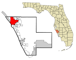
Coordinates: 27°20′14″N 82°32′7″W / 27.33722°N 82.53528°WCoordinates: 27°20′14″N 82°32′7″W / 27.33722°N 82.53528°W Country United States State Florida County Sarasota Zarazote 1763 Fort Armistead 1840 Sara Sota 1842 Government - Type commission-manager - ceremonial mayor rotates annually - city manager Robert J Bartolotta Area[3] - City 25.93 sq mi (67.2 km2) - Land 14.89 sq mi (38.6 km2) - Water 11.04 sq mi (28.6 km2) 42.58% Elevation[4] 16 ft (7 m) Population (1 July 2007)[5] - City 52,578 - Density 3,539.8/sq mi (1,366.7/km2) - Metro 673,035 Time zone EST (UTC-5) - Summer (DST) EDT (UTC-4) ZIP code 34230 - 34243 Area code(s) 941 FIPS code 12-64175[6] GNIS feature ID 0290675[7] Website http://www.sarasotagov.com Sarasota is a city located in Sarasota County on the southwestern coast of the U.S. state of Florida. It is south of the Tampa Bay Area and north of Fort Myers. Its current official limits include Sarasota Bay and several barrier islands between the bay and the Gulf of Mexico.
These islands separating Sarasota Bay from the gulf near the city, known as keys, include Lido Key and Siesta Key, which are famous worldwide for the quality of their sandy beaches.
Today the keys that are included in the boundary of Sarasota are Lido Key, St. Armands Key, Otter Key, Coon Key, Bird Key, and portions of Siesta Key. Previously, Siesta Key was named Sarasota Key. At one time, it and all of Longboat Key were considered part of Sarasota and confusing contemporaneous references may be found discussing them.
Longboat Key is the largest key separating the bay from the gulf, but it is now evenly divided by the new county line of 1921. The portion of the key that parallels the Sarasota city boundary that extends to that new county line along the bay front of the mainland was removed from the city boundaries at the request of John Ringling in the mid-1920s, who sought to avoid city taxation of his planned developments at the southern tip of the key. Although they never were completed in the quickly faltering economy, those development concessions granted by the city never were reversed and the county has retained regulation of those lands ever since.
According to the U. S. Census Bureau, Sarasota had a population of 52,488 in 2007.[8] In 1986 it became designated as a certified local government. Sarasota is a principal city of the Bradenton-Sarasota-Venice, Florida Metropolitan Statistical Area, and is the seat of Sarasota County.
It is among the communities included in a two-county federally mandated Metropolitan Planning Organization that includes all of Sarasota and Manatee counties[9] and the chairs of the three elements of that organization belong to the eight-county regional planning organization for western central Florida.[10]
President Bush was visiting an elementary school in Sarasota when the September 11 attacks took place.
Contents
History
Prehistorical data
 Gulf of Mexico in 3-D - note the shallow shelf extending one hundred miles to the west of Sarasota (red dot) that was above water fifteen thousand years ago when humans began occupation of Florida; the ancient shoreline that existed fifteen thousand years ago is depicted in light blue
Fifteen thousand years ago, when humans first settled in Florida, the shoreline of the Gulf of Mexico was one hundred miles farther to the west. In this era, hunting and gathering was the primary means of subsistence. This was only possible in areas where water sources existed for hunter and prey alike. Deep springs and catchment basins, such as Warm Mineral Springs, were close enough to the Sarasota area to provide camp sites, but too far away for permanent settlements.
As the Pleistocene glaciers slowly melted, a more temperate climate began to advance southward. Sea levels began rising; they ultimately rose another 350 feet (110 m), resulting in the Florida shoreline of today, which provided attractive locations for human settlements.
Archaeological research in Sarasota documents more than ten thousand years of seasonal occupation by native peoples. For five thousand years while the current sea level existed, fishing in Sarasota Bay was the primary source of protein and large mounds of discarded shells and fish bones attest to the prehistoric human settlements that existed in Sarasota and were sustained by the bounty of its bay.
Early historical records
Europeans first explored the area in the early 16th century. The first recorded contact was in 1513, when a Spanish expedition landed at Charlotte Harbor, just to the south.
Having been identified on maps by the mid-18th century as Zara Zote,[11] perhaps from an indigenous name, the sheltered bay and its harbor attracted fish and marine traders. Soon there were fishing camps, called ranchos, along the bay that were established by both Americans and Cubans who traded fish and turtles with merchants in Havana. Florida changed hands among the Spanish, the English, and the Spanish again.
After the 1819 acquisition of Florida as a territory by the United States and five years before it became a state in 1845, the army established Fort Armistead in Sarasota along the bay.
The fort is thought to have been located in the Indian Beach area, and research continues there. The army established the fort at a rancho operated by Louis Pacheco, an African slave working for his Cuban-American owner. Drawings of the fort give a clue to the location as well, showing a significant landmark point that still exists at Indian Beach. Shortly before the fort was abandoned because of severe epidemics, the chiefs of the Seminole Indians gathered to discuss their impending forced march to the Oklahoma Territory. These were Native Americans who had moved into Florida during the Spanish occupation. Most of the indigenous natives of Florida, such as the Tocobaga and the Caloosa, had perished from epidemics carried by the Spanish. They mostly had maintained permanent settlements that were used from late Fall through Spring, moving to settlements farther north during the Summer.
Soon the remaining Seminole Indians were forced south into the Big Cypress Swamp and in 1842 the lands in Sarasota, which then were held by the federal government, were among those opened to private ownership by those of European descent via the Armed Occupation Act passed by the Congress of the United States. Even Louis Pacheco had been deported with the Indians to Oklahoma.
Pioneer families
 The Browning and Whitaker pioneer families, gathered for a photograph in Sarasota, Florida during 1886 - Sarasota County History Center collection
European settlers arrived in significant numbers in the late 1840s. The area already had a Spanish name—'Zara Zote'—on maps dating back to the early 18th century and it was retained as, Sara Sota. The initial settlers were attracted by the climate and the bounty of Sarasota Bay.
William Whitaker, born in Savannah, Georgia in 1821, was the first documented pioneer of European descent to settle permanently in what became the city of Sarasota.[12] Before his arrival, both Cuban and American fishermen had built fish camps or ranchos along Sarasota Bay, but these were not used throughout the year. After time spent along the Manatee River at the village of Manatee, Whitaker built upon Yellow Bluffs, just north of present day Eleventh Street. He sold dried fish and roe to Cuban traders working the coast. In 1847, he began a cattle business.
In 1851, Whitaker married Mary Jane Wyatt, a member of a pioneer family who had settled the village of Manatee, that was about thirteen miles (19 km) to the northeast along the river of the same name. They raised eleven children on Yellow Bluffs despite the hardships faced by solitary pioneers.
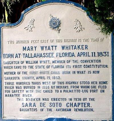
 Historical marker dedicated to Mary Jane Wyatt Whitaker near her pioneer residence and tomb
Those hardships included a raid that destroyed their home. The raid was made by a formerly friendly Seminole chief, Holata Micco, dubbed Billy Bowlegs, after whom Bowlees Creek may have been named. They were not injured, but the house was burnt to the ground.
The Whitakers rebuilt and prospered. Unfortunately, their homestead site has not been preserved, having been developed in the 1980s. Their family cemetery remains, however. In the 1930s the Whitaker family gave the cemetery to the Daughters of the American Revolution on the understanding that any lineal descendants of William and Mary Whitaker and their spouses could be buried there as long as space remained. There are eighty-five plots in all, with thirty-nine taken to date.
In 1867, the Webb family from Utica, New York, came to Florida looking for a place to settle. After arriving in Key West, the pioneer family met a Spanish trader. He told them about a high bluff of land on Sarasota Bay that would make a good location for a homestead. When the Webbs arrived in Sarasota looking for the bluff, they described it to Bill Whitaker. He led them right to it because of the description. The site was several miles south of the settlement of the Whitakers. After settling, the Webbs named their homestead Spanish Point, in honor of the trader.
The Webbs had to travel quite a distance for their mail for nearly twenty years. In 1884, John Webb finally petitioned for a separate postal address for Spanish Point. They chose Osprey as their postal address, since federal regulations required the use of only one word for the new address. A separate town eventually grew around that postal address. Although there is no similar documentation regarding the name of Sarasota, that federal one-word rule for postal designations may be the reason that Zara Zota or Sara Sota became Sarasota.
Sarasota has been governed by several different American counties, depending upon the era. Not becoming a state until 1845 Florida was acquired by the United States as a territory in 1819. Hillsborough County was created from Alachua and Monroe counties in 1834 and many early land titles cite it as the county governing Sarasota. Hillsborough was divided in 1855, placing Sarasota under the governance of Manatee County until 1921, when three new counties were carved out of portions of Manatee. One of those new counties was called, Sarasota, and the city was made its seat. The boundary of the community once extended to Bowlees Creek, but that was redrawn to an arbitrary line in order to divide the airport so its oversight could include both counties. Property records and street addresses north of that new county line and south of the creek, however, remain as "Sarasota" due to established postal designations, although they remain governed by Manatee County.
To recover from the debt the state incurred through defeat in the Civil War, the central portions of Florida were drained and sold internationally to developers in the North and abroad during the 1880s.
In 1885 a Scots colony was established in Sarasota that related it as a tropical paradise that had been built into a thriving town.[13] A town had been platted and surveyed before the parcels were sold by the Florida Mortgage and Investment Company. When the astonished investors in the "Ormiston Colony" arrived by ship in December they had to wade ashore, only to find that their primitive settlement lacked the homes, stores, and streets promised. They were even more disturbed by the snowfall that occurred a few weeks later.
Only a few Scots, such as the Browning family, remained in Sarasota along with a determined member of the developer's family, John Hamilton Gillespie. He was a manager for Florida Mortgage & Investment Company, and began to develop Sarasota following the plan for the failed colony. In 1887 he built the De Sota Hotel which opened on February 25 hosting a large social event and celebration. In May 1886 he completed a two hole golf course which is thought to be one of the first golf courses in America. By 1905 he had completed a nine hole 110-acre course to support his favorite pastime, golf. Eventually tourists arrived at a dock built on the bay.
Rose Phillips Wilson and her husband C. V. S. Wilson founded The Sarasota Times newspaper in 1899. It was the first newspaper published in Sarasota and Rose Wilson continued publication of the paper alone until 1923 after her husband died in 1910. She participated in the leadership of the community through many organizations and provided editorial opinions on most early issues.
Well respected among her peers in journalism, the Tarpon Springs Leader ranked the Times under her ownership, as "the best weekly paper in the state" and after the state legislature passed a bill to create Sarasota County, it was to Rose Wilson that the telegram was sent to announce it. When a referendum endorsed the split from Manatee locally, Wilson changed the name of her newspaper to The Sarasota County Times.
She lived through the World War I period, the 1920s boom period, the depression, World War II, and Sarasota’s second boom period in the 1950s. After her retirement from publishing in 1923 Wilson continued her community work with many local organizations, including the influential Woman’s Club in Sarasota, into the 1940s. She devoted much of her time as teacher and mentor for youth at First Presbyterian Church and lived to be eighty-eight years old, when she died in 1964.[14]
Twentieth century development
The village of Sarasota was incorporated for local government as a town under state guidelines in 1902 with John Hamilton Gillespie as mayor. It was re-platted in 1912 and its government then was incorporated as a city in 1913, with A. B. Edwards as mayor.
Owen Burns
 A youthful Owen Burns - Sarasota County History Center
Owen Burns had come to Sarasota for its famed fishing and remained for the rest of his life. Not only did he become the largest landowner in the city, but he founded a bank, promoted the development of other businesses, and built its bridges, landmark buildings, and mansions. He dredged the harbor and created new bay front points with reclaimed soils. He created novel developments such as Burns Court to attract tourists and built commercial establishments to generate additional impetus to the growing community.
He also went into a business partnership with John Ringling to develop the barrier islands, a fateful decision that bankrupted him when his partner failed to live up to commitments on development agreements. In 1925 Burns built the El Vernona Hotel, naming it after his wife, Vernona Hill Freeman Burns. Shortly after the opening of the hotel, the land boom crash in Florida struck a fatal blow to his finances because of the unfulfilled partnership agreement. Ironically, it was the same former partner, John Ringling, who took advantage of the situation and purchased the hotel for a portion of its value, although several years later, with the crash of the stock market, Ringling would meet the same financial fate.
Beside the landmarks, bridges, and developments he built, Burns contributed to the attraction of many around the country to Sarasota. Among his five children, he also raised the most important historian for the community, his daughter, Lillian G. Burns.
Bertha Palmer
 Bertha Honoré Palmer - the largest landholder, rancher, farmer, and developer of the area at the turn of the twentieth century, who made Sarasota a winter destination for wealthy families and revolutionized the farm and cattle business in the state - Sarasota County History Center collection
Bertha Palmer (Bertha Honoré Palmer) was the region's largest landholder, rancher, and developer after the turn of the 20th century, where she purchased more than 90,000 acres (360 km2) of property.[15] She was attracted to Sarasota by an advertisement placed in a Chicago newspaper by A. B. Edwards. They would maintain a business relationship for the rest of her life. The Palmer National Bank, established on Main Street at Five Points, remained a strong bank led by her sons through the depression and merged with Southeast Bank in 1976.[16]
Bertha Palmer also owned a large tract of land that now is Myakka State Park. During this period this land was operated as a ranch. She developed and promoted many innovative practices that enabled the raising of cattle to become a large-scale reality in Florida. At her "Meadowsweet Farms", Palmer also pioneered large-scale farming and dairy in the area and made significant contributions to practices that enabled the development of crops that could be shipped to markets in other parts of the country. Her experimentation was coordinated with the state department of agriculture.
As war in Europe threatened, Bertha Palmer touted the beauty of Sarasota and its advantages to replace the typical foreign destinations of her social peers. Palmer made her winter residence on the land which the Webb family had homesteaded. She built a resort that would appeal to these new visitors to the area. She quickly established Sarasota as a fashionable location for winter retreats of the wealthy and as a vacation destination for tourists, which endured beyond the war years and blossomed for the new wealth that developed more broadly in the United States during the 1920s and, after the Second World War as well.[17]
In her early publicity, Palmer compared the beauty of Sarasota Bay to the Bay of Naples, and also touted its sports fishing. As the century advanced, the bounty of the bay continued to attract visitors, until overfishing depleted its marine life.
Palmer retained most of the original Webb Family structures and greatly expanded the settlement. The pioneer site has been listed on the National Register of Historic Places as Historic Spanish Point and is open to the public for a fee. Her tourist accommodations at The Oaks have not been preserved, however.
Also arriving in 1910, Owen Burns closely followed Bertha Palmer to Sarasota and with two purchases, he quickly became the largest landholder within what now is the city, therefore many of the huge Sarasota properties she owned are in what now is Sarasota County (which did not exist during her lifetime). Many of its roads bear the names she put on the trails she established. She did participate, however, in speculation in the city along with others, purchasing undeveloped land in great quantities, and many parcels bear her name or that of her sons among those in abstracts.
Her sons continued her enterprises and remained as investors and donors in Sarasota after the death of Bertha Palmer in 1918. Aside from drawing worldwide attention to the city as a vacation destination and a chic location for winter residences, as well as being renowned for the ranching and agricultural reforms she introduced, two state parks are located on properties she held, portions of the Oscar Scherer State Park and the enormous Myakka River State Park, that may be counted as her greatest tangible legacy to Sarasotans.
Other developments and early history
Other communities in the area were incorporated or began to grow into towns that were quite distinct from the bay front community whose plat ended at what is now Tenth Street. They have been absorbed as Sarasota grew, but some have retained their names and are recognized today as neighborhoods. Some communities, such as Overtown, Bay Haven, Indian Beach, Shell Beach, Bee Ridge, and Fruitville have all but faded from the memory of most living there now. Overtown expanded to include what now is designated as the historic Rosemary District and the boundaries of Newtown now merge with that. The Ringling College of Art and Design includes for its administration building, a hotel developed for the community of Bay Haven when Old Bradenton Road was the main thoroughfare north to the Manatee River. That route avoided having to cross the broadest portion of Bowless Creek. Tamiami Trail was developed in the mid-1920s and a bridge across the creek eliminated it as a natural barrier limiting development. Shell Beach became the location where the grand estates would be built on the highest land along the bay as well as where the Sapphire Shores and The Uplands developments are today.
 Map of McClellan Park - a bay and bayou front subdivision designed by Katherine McClellan and Daisietta McClellan in 1913 - Sarasota County History Center collection
Two sisters, Katherine McClellan and Daisietta McClellan, became real estate developers during this period. They created the McClellan Park subdivision, which is one of the most significant and successful residential neighborhoods south of downtown. Their plat was filed in 1913. It deviated from the typical grid system used for large developments, created a closely knit community, and provided a yacht basin, tennis courts, and other recreational sport facilities.
Women have played a significant role in the development of Sarasota, perhaps not so contrary to many communities, but the history of Sarasota has documented their roles very publicly. Bertha Palmer was not so unusual here, Many other examples may be found by exploring the county records at the Sarasota County History Center.
An area in northern Sarasota attracted many of the Ringling brothers, who had created their wealth as circus magnates, at the turn of the century. The Ringling Brothers Circus had not yet consolidated as a single entity.
Mary Louise and Charles N. Thompson platted Shell Beach in 1895. The Thompson home was the first residence on the property. It extended from what is now Sun Circle almost to Bowlees Creek. From 1911 Mable and John Ringling spent their winter stays in that house and eventually, they would purchase a large parcel of Thompson property for their permanent winter quarters in Sarasota. Along with being a land developer, Thompson was a manager with another circus. He attracted several members of the Ringling family to Sarasota as a winter retreat as well as for investments in land.
First, the Alf T. Ringling family settled in the Whitfield Estates area with extensive land holdings. The families of Charles and John Ringling followed, living farther to the south. Soon, children and members of the extended family increased the presence of the Ringling family in Sarasota. Ringling Brothers Circus established its winter home in Sarasota during 1919 following the death of Alf T., when Charles Ringling assumed many of his duties.
Charles Thompson had joined the staff of the Ringling Brothers Circus when it began to purchase smaller or failing circuses, and to operate them separately. In 1919, these holdings were consolidated into one huge circus, billed as "the greatest show on Earth". Only two of the original five founding brothers now survived, but other members of their families continued to participate in the business or serve on its board of directors. Performers and staff members began to settle in Sarasota, and established the Ringling Circus as part of the Sarasota community.
Following the end of World War I, an economic boom began in Sarasota. The city was flooded with new people seeking jobs, investment, and the chic social milieu that had been created by earlier developers.
 Cà d'Zan, Mable and John Ringling 1925 Sarasota residence, now listed on the National Register of Historic Places - architect Dwight James Baum, built by Owen Burns
On adjacent parcels of Thompson's Shell Beach where Ellen and Ralph Caples built their winter retreat, Mable and John Ringling built their compound. It soon would include the museum. Edith and Charles Ringling built a compound that included a home for their daughter, Hester Ringling Landcaster Sandford.
The next large Shell Beach parcel, immediately to the north, passed between Ellen Caples, Mable and John Ringling, and a few others several times without development until 1947. It was then developed as The Uplands. Some other historic names associated with that parcel are Bertha Palmer, her son Honoré, and A. B. Edwards, whose names are featured as familiar street names in Sarasota.
The tract abutting that parcel was re-platted in 1925 as Seagate with the intention of creating an entire subdivision. This is where Gwendolyn and Powel Crosley built their winter retreat in 1929. All of these historic homes and the museum have been listed on the National Register of Historic Places.
The now-historic neighborhood of Indian Beach Sapphire Shores grew immediately to the south of the area where these grand homes were built on the bay. Sapphire Shores provided homes to the professionals and retirees who wished to be, or were, closely associated with these wealthiest residents of the community. Indian Beach, which had been a separate community at one time, contained pioneer homes that survived among the fashionable new homes built during the boom era of the 1920s.
Charles Ringling as developer
Charles Ringling invested in land, developed property, and founded a bank. He participated in Sarasota's civic life and gave advice to other entrepreneurs starting new businesses in Sarasota. From his bank, he loaned money to fledgling businesses. Encouraging its creation, he donated land to the newly formed county—upon which he also built its government offices and courthouse as a gift to the community.
Ringling Boulevard was named for Charles Ringling. It is a winding road leading east from the bay front at what now is Tamiami Trail toward the winter circus headquarters. It crosses Washington Boulevard where Charles Ringling built the Sarasota Terrace Hotel, a high-rise in the Chicago style of architecture, opposite the site which Ringling would donate for the county seat. It was readily accessible by train at the time.
Charles Ringling and his wife, Edith, began building their bay front winter retreat in the early 1920s. Charles Ringling died in 1926, just after it was completed. For decades Edith Ringling remained there and continued her role in the administration of the circus, assuming many duties of her husband, and her cultural activities in the community. Her daughter, Hester, and her sons were active in Sarasota's theatrical and musical venues. What came to be known internationally as the Edith Ringling Estate is now the center of the campus of New College of Florida.[18][19]
John Ringling in partnership with Owen Burns
John Ringling invested heavily in developments on the barrier islands, known as keys, which separate the shallow bay from the Gulf of Mexico. Although he had several corporations and development projects in Sarasota, he worked in partnership with Owen Burns to develop the keys through a corporation named, Ringling Isles Estates. Burns owned all of Lido Key. To facilitate development of these holdings a bridge was built to the islands by his partner, Owen Burns. Eventually Ringling donated the bridge to the city for the government to maintain. They named that route, John Ringling Boulevard. The center of Saint Armand key contains Harding Circle and the streets surrounding it are named for other U.S. presidents. Dredge and fill by Owen Burns created even more dry land to develop, including Golden Gate Point. Winter residents, called snowbirds, flocked to purchase these seasonal homes marketed to the well-to-do.
Leading edge of the 1920s crash
See also: Florida land boom of the 1920sThe Roaring Twenties ended early for Sarasota. Florida was the first area in the United States to be affected by the financial problems that led to the Great Depression. In 1926 development speculation began to collapse with bank failures on the eastern coast of Florida, much earlier than most parts of the country. The financial difficulties spread throughout Florida. John Ringling initially profited from the economic crash. Ringling had put his partner, Owen Burns, into bankruptcy by using money from the treasury of their corporation for use on another Ringling project that was failing. He later purchased the landmark El Vernona Hotel from Burns at a fraction of its worth. John Ringling, too, however, lost most of his fortune. Shortly after the June 1929 death of his wife, Mable, his reversal began because his stock investments were affected.
Just before the market crashed, Ringling had purchased several other circuses with hopes of combining them with the existing circus and selling shares on the stock exchange. The crash ended that plan. While Ringling continued to invest in expensive artwork, he left grand projects unfinished, such as a Ritz hotel on one of the barrier islands. He abandoned plans for an art school as an adjunct to the museum. Ringling did lend his name to an art school established by others in Sarasota, however reluctantly.
The board of the circus, which included Edith Ringling and other members of the family, removed John Ringling and placed another director, Samuel Gumpertz, in charge of the corporation. By the time of his death in 1936, John Ringling was close to bankruptcy. His estate was saved only because he had willed it, together with his art collection, to the state and he died just before he would have become bankrupt. A film about the estate that is shown to museum visitors, states that his bank balance was less than four hundred dollars when he died. His nephew, John Ringling North, struggled for years to keep that legacy intact.
A new city plan
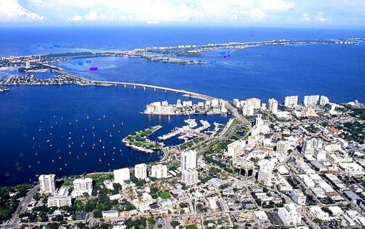
 Sarasota - from mainland showing much of downtown (from Burns Square to Main Street in the extreme foreground) and the bay front from Marie Selby Botanical Gardens to the Van Wezel Performing Arts Hall, as well as Sarasota Bay, portions of her keys, and the Gulf of Mexico in the distance
In 1925 John Nolen, a professional planner, was hired to develop a plan for the downtown of the city. He laid out the streets to follow the arch of the bay front with a grid beyond, that extended north to what is now Tenth Street and south to Mound. This followed more closely the way the city was developing at the time.
The names and numbers of the downtown streets were changed to the current ones. At that time the numbered streets began at Burns Square and Burns' triangular building separating the intersection of Orange and Pineapple Avenues, was on First Street. Nolen shifted the existing numbered streets to the north, beginning above what now is Main Street. The city hall, situated in the Hover Arcade at the foot of Main Street, was on the waterfront and the city dock extended from it. It was the hub of the new city. Vehicles and materials could pass through the arcade and railroad tracks led directly to the terminus.
The new plan accentuated that city hall on the bay front, was the nexus of the city. Broadway, the road that connected the downtown bay front with the northern parts of the city along the bay had become part of the new Tamiami Trail that was being created. The trail was a portion of U.S. 41 that connected Tampa to Miami (hence the contracted name) in 1928. United with U.S. 301 in northern Manatee County, the trail made a "dog's leg" turn toward the west at Cortez Road. In Sarasota it turned back toward the east to follow Main Street through downtown before rejoining U.S. 301 at Washington Boulevard.
 Tamiami Trail is shown as a bold dotted line running north to south and marked U.S. 41, as it traverses Sarasota, Florida, which is shown in gold
This plan was abandoned in the 1960s when pressure to increase speeds on Tamiami Trail drove the demolition of the city hall and the redirection of the route past the bay front, severing the community from the waterfront. By the last decade of the century, automobile traffic had become so dominant that intersections beyond human-scale barred all but the most adventurous from attempting crossings on foot. At community planning charrettes, designs began to circulate that called for the reunification of the downtown to the bay front and removal of the designation of the bay front road as a highway. New Urbanism concepts focused upon restoring Sarasota to being a walkable community and taking the greatest advantage of its most beautiful asset, Sarasota Bay. Roundabouts were discussed as traffic calming devices that could be integrated into gracious designs for safe and efficient movement of automobiles among increased use by bicyclists and pedestrians, along with reduction of pollution.
Twenty-first century
Another speculation crash
The boom of the 1950s failed to end in a crash, but almost a hundred years after the first speculation crash that affected her so badly in the mid-1920s, [1] Sarasota became identified as the epicenter of the 2008 real estate crash. [2] [3] It followed financial credit problems that began with poorly financed mortgages failing because of massive real estate speculation that began in the late 1990s and escalated dramatically during the early 2000s. [4] Once the values of the properties began to fall the mortgages purchased with consideration of "equity value" derived from the rapid increases in property values due to speculation, became problematic. The properties were no longer worth the value of the mortgages, some by great differences. The rate of foreclosures is increasing as the values remain low and governments are losing taxes to support services because of the decline in values. This became almost a nation-wide problem and occurred in other countries as well. Although not over yet, it is likely to be labeled as another boom period-crash, not in undeveloped land and not just in Florida, but this time it began with equity-based home mortgages and has led to a major financial crisis.
Geography and climate
Sarasota is located by 27°20′14″N 82°32′7″W / 27.33722°N 82.53528°W (27.337273, -82.535318).[20]
According to the United States Census Bureau, the city has a total area of 25.9 square miles (67 km2), of which 14.9 square miles ( 38.6 km²) is land and 11.0 square miles (28 km2) is water.
Sarasota has a humid subtropical climate, with hot summers, mild winters, and high humidity year-round. There are distinct rainy and dry seasons in Sarasota, with the rainy season lasting from June to September, and the dry season from October to May.
Climate data for Sarasota, FL Month Jan Feb Mar Apr May Jun Jul Aug Sep Oct Nov Dec Year Record high °F (°C) 89
(32)88
(31)90
(32)94
(34)95
(35)100
(38)100
(38)99
(37)97
(36)95
(35)90
(32)89
(32)100
(38)Average high °F (°C) 72
(22)74
(23)77
(25)82
(28)87
(31)90
(32)91
(33)91
(33)90
(32)85
(29)80
(27)74
(23)83 Average low °F (°C) 51
(11)53
(12)57
(14)60
(16)65
(18)74
(23)73
(23)73
(23)72
(22)65
(18)59
(15)53
(12)63 Record low °F (°C) 23
(−5)24
(−4)30
(−1)38
(3)46
(8)52
(11)62
(17)60
(16)59
(15)44
(7)29
(−2)20
(−7)20
(−7)Precipitation inches (mm) 2.94
(74.7)2.66
(67.6)3.36
(85.3)1.85
(47)2.85
(72.4)7.41
(188.2)8.71
(221.2)9.43
(239.5)7.25
(184.2)2.88
(73.2)2.35
(59.7)2.45
(62.2)54.14
(1,375.2)Source: The Weather Channel[21] Demographics
Historical populations Census Pop. %± 1910 840 — 1920 2,149 155.8% 1930 8,398 290.8% 1940 11,141 32.7% 1950 18,896 69.6% 1960 34,083 80.4% 1970 40,237 18.1% 1980 48,868 21.5% 1990 50,961 4.3% 2000 52,715 3.4% 2010 51,917 −1.5% Population 1910-2010.[22] As of the census[6] of 2000, there were 52,715 people, 23,427 households, and 12,064 families residing in the city. The population density was 3,539.8 per square mile (1,366.9/km²). There were 26,898 housing units at an average density of 1,806.2 per square mile (697.5/km²). The racial makeup of the city was 76.91% White, 16.02% African American, 0.35% Native American, 1.02% Asian, 0.05% Pacific Islander, 3.74% from other races, and 1.91% from two or more races. Hispanic or Latino of any race were 11.92% of the population.
There were 23,427 households out of which 19.7% had children under the age of 18 living with them, 35.3% were married couples living together, 12.3% had a female head of household with no husband present, and 48.5% were non-families. 38.3% of all households were made up of individuals and 16.3% had someone living alone who was 65 years of age or older. The average household size was 2.12 and the average family size was 2.81.
In the city the population was spread out with 18.4% under the age of 18, 9.2% from 18 to 24, 27.9% from 25 to 44, 22.5% from 45 to 64, and 22.0% who were 65 years of age or older. The median age was 41 years. For every 100 females there were 94.6 males. For every 100 females age 18 and over, there were 92.8 males.
The per capita income for residents of the city was $23,197. Females had a median income of $23,510 versus $26,604 males.
The median income for a household in the city was $34,077 and the median income for a family was $40,398. About 12.4% of families and 16.7% of the population were below the poverty line, including 28.5% of those under age 18 and 7.7% of those age 65 or over.
From 2005-2007, Sarasota County had a total population of 368,000 - 192,000 (52 percent) females and 176,000 (48 percent) males. The median age was 49.7 years. Seventeen percent of the population was under 18 years and 30 percent was 65 years and older.
The Age Distribution of People in Sarasota County, Florida in 2005-2007 65 and over 30% 45 to 64 27% 25 to 44 21% 18 to 24 6% Under 18 17% Percent of population For people reporting one race alone, 92 percent was White; 4 percent was Black or African American; less than 0.5 percent was American Indian and Alaska Native; 1 percent was Asian; less than 0.5 percent was Native Hawaiian and Other Pacific Islander, and 2 percent was Some other race. One percent reported two or more races. Seven percent of the people in Sarasota County was Hispanic. Eighty-seven percent of the people in Sarasota County was White non-Hispanic. People of Hispanic origin may be of any race.
The per capita income for the county was $28,326 and females had a median income of $25,721 versus $32,114 for males.
The median income of households in Sarasota County was $49,030. Sixty-three percent of the households received earnings and 28 percent received retirement income other than Social Security. Forty-five percent of the households received Social Security. The average income from Social Security was $16,654. These income sources are not mutually exclusive; that is, some households received income from more than one source.
In 2010 Sarasota had a population of 51,917. The racial and ethnic composition of the population was 65.6% non-Hispanic white, 15.1% black or African American, 0.4% Native American, 0.3% Asian Indian, 1.0% other Asian, 0.2% non-Hispanic reporting some other race, 2.3% reporting two or more races and 16.6% Hispanic or Latino.[23]
Government
Sarasota municipal government was last incorporated in 1913, adopting the city type of local government found in the United States. The title of its government is City of Sarasota and it is governed by a five-person commission elected by popular vote, two members of which serve in the ceremonial positions of mayor and vice-mayor as chosen by the commission every April. Sarasota later was designated as the county seat when Sarasota County was carved out of Manatee County in 1921 during the creation of several new counties.
Many aspects of the city are overseen by the county government ranging from parks, the bay, major waterways, county designated roads, the airport, fire departments, property and ad valorum taxes, voting, the health department, extension services, storm water control, mosquito control, the courts, the jail, libraries, and schools therefore election of county commissioners is important to city voters.
In January 2006, the city of Sarasota made national news when the National Coalition for the Homeless and the National Law Center on Homelessness and Poverty ranked it number one on the groups' list of twenty "meanest cities" in America in their published report A Dream Denied: The Criminalization of Homelessness in U.S. Cities.[24] The city's 2005 ordinance (05-4640) made it illegal to sleep outside on public or private property without permission.[25][26]
The City of Sarasota offers the following services to residents within the incorporated city limits.
- Sarasota Police Department
- Public Works - Garbage pick-up
- Utilities Department - Water
- Parks - City owned, County operated, including the Van Wezel.
Culture
In 1926, A. B. Edwards built a theater that could be adapted for either vaudeville performances or movie screenings. It is situated at the intersection of Pineapple Avenue and Second Street, having been restored and used for operas. It is listed on the National Register of Historic Places.
Sarasota is the home of the Sarasota Orchestra, which was founded by Ruth Cotton Butler in 1949 and known for years as the Florida West Coast Symphony. It holds a three-week Sarasota Music Festival that is recognized internationally and boasts that it attracts renowned teachers and the finest students of chamber music.
In the early 1950s, the John and Mable Ringling Museum of Art purchased a historic Italian theater, the Asolo (now called the Historic Asolo Theater). A. Everett "Chick" Austin, the museum's first director, arranged the purchase and reassembly of the theater for performances of plays and opera. The theater had been built in 1798 and was disassembled during the 1930s. Adolph Loewi, a Venetian collector and dealer, had purchased the theater and stored its parts until the purchase and shipment to Sarasota for the museum. The theater was rebuilt in a building that extended to the west of the northern wing of the museum, where John Ringling had intended his unrealized art school would be built. The new building, containing the historic theater, was separated from the museum by a small garden that featured statues of dwarfs. In the 1980s, the theater was used by a foreign film club that showed its films on Monday nights. When the club expanded, it built its own theater at Burns Court near Burns Square in downtown Sarasota.
Later a local architect, Stuart Barger, designed and oversaw the construction of another Asolo Theater, housed in the Florida State University Center for the Performing Arts. It is a multi-theater complex, located farther east on the John and Mable Ringling Museum of Art property, being placed between Bay Shore Road and Tamiami Trail, and facing south toward Ringling Plaza. It was built around a rococo, historic Scottish theater, which had been shipped to Florida. The new complex also provides venues and facilities for students of Florida State University's MFA Acting program, the FSU/Asolo Conservatory for Actor Training. This was the administrative home of the Sarasota French Film Festival for several years. Venues around the city were used for films and events that focused upon French films and their stars.
In the 1960s the Van Wezels enabled the city to build a performing arts hall on the bay front. The auditorium, the Van Wezel Performing Arts Hall, was designed by Frank Lloyd Wright's successor firm, Taliesin Associated Architects team under the direction of William Wesley Peters. Wright's widow, Olgivanna Lloyd Wright, who participated in the project, selected its purple color.
Other Sarasota cultural attractions include the Sarasota Ballet, Sarasota Opera, Asolo Repertory Theatre, Florida Studio Theatre, the Sarasota Players, the Banyan Theater Company, and many other musical, dance, artistic, and theatrical venues. Since 1998, the city has hosted the Sarasota Film Festival annually. The festival attracts independent films from around the world. It claims to be one of Florida's largest film festivals. In 2009 the annual Ringling International Arts Festival, held its premier and held its closing event in the historic Asolo theater, which had been moved and rebuilt again. The historic Venetian theater now is housed in the reception building for the museum where it is used for special events as well as performances, informative purposes, and another seasonal film series hosted by the museum.
In 2010, the Sarasota Chalk Festival that is held yearly in the historic area Burns Square became the first international street painting festival in the United States of America. Celebrating the 16th century performance art of Italian street painting the festival hosted Maestro Madonnaro Edgar Mueller from Germany who created the first street painting that changed images from day to night.[27][28][29][30]
Sarasota is home to Mote Marine Laboratory, a marine rescue, research facility, and aquarium; Marie Selby Botanical Gardens; G-Wiz Museum; and Sarasota Jungle Gardens, which carries on early tourist attraction traditions. It also has many historic sites and neighborhoods.
Colleges in Sarasota include New College of Florida, a public liberal arts college; Keiser College of Sarasota, a private college; FSU/Asolo Conservatory for Actor Training (Florida State University's MFA Acting Conservatory in conjunction with the Asolo Repertory Theatre); Ringling College of Art and Design, a school of visual arts and design; and satellite campuses of Eckerd College, based in St. Petersburg, Florida; and Florida State University College of Medicine, based in Tallahassee, Florida. Other colleges in the city include East West College of Natural Medicine, an accredited college of acupuncture and Chinese medicine.
Nearby educational institutions with regional draw include State College of Florida, Manatee-Sarasota and a commuter branch of the University of South Florida, based in Tampa.
Italian architecture and culture is quite strong in the area because of the Ringling Museum. An unusually large amount of homes and buildings are designed in the Italian style, especially Venetian as influenced by Ringling's Ca'd'Zan. Italian inspired statues are also common and Michelangelo's David is used as the symbol of Sarasota.
 March 2007, Riverview High School
The Sarasota School of Architecture has developed as a variant of mid-century modernist architecture. It incorporates elements of both the Bauhaus and Frank Lloyd Wright's "organic" architecture. The style developed as an adaptation to the area's sub-tropical climate and used newly emerging materials manufactured or implemented following World War II. Philip Hiss was the driving force of this movement.
Fellow architects creating new adaptive designs were Paul Rudolph and Ralph Twitchell. The second generation of the school includes Gene Leedy, Jack West, Victor Lundy, Mark Hampton, James Holiday, Ralph Zimmerman, as well as several who still practice in the community: William Zimmerman; Carl Abbott, Edward J. "Tim" Seibert, and Frank Folsom Smith.
Rudolph's Florida houses attracted attention in the architectural community around the world. He started receiving commissions for larger works, such as the Jewett Art Center at Wellesley College. In 1958 Rudolph was selected as director of the School of Architecture at Yale, shortly after designing the school's building. He led the school for six years before returning to private practice.
Recently a bank building designed and built by Jack West was renovated and reopened as the headquarters of Gateway Bank on Tamiami Trail at the intersection with Bahia Vista. This followed a preliminary proposal to demolish the building that met with a rapid objection from a leader of historic preservation in the community before the new project could gain approval within the city planning department. The building is graced by a sculpture by Jack Cartlidge that was installed when the building was built.
Media
Sarasota is part of the Nielsen-designated Tampa-Saint Petersburg-Sarasota television market.[31] The local television stations are ABC-affiliate WWSB and SNN Local News 6, a continuous local cable news operation run by Comcast and the Sarasota Herald-Tribune. WWSB is the only network station with studios in Sarasota. Other network and public television programming serving the community is offered by Fort Myers and Tampa television stations. Comcast provides cable television service. DirecTV and Dish Network provide direct broadcast satellite television including Tampa Bay Area local and national channels to Sarasota residents.
Arbitron has identified the Sarasota-Bradenton radio market as the seventy-third largest market in the country,[32] and the sixth largest in the state of Florida. There are eight radio stations in the city: WSMR (89.1FM, classical music), WSLR (96.5FM, variety-talk), WKZM (104.3FM, religious; repeating WKES Lakeland), WCTQ (106.5FM, country music), WSRZ (107.9FM, oldies), WLSS (930AM, talk), WSRQ (1220AM, talk), WTMY (1280AM, talk), WTZB (105.9FM, rock music; commonly known as The Buzz) and WSDV (1450AM, adult standards). WHPT (102.5 FM, classic rock) is licensed to Sarasota and has broadcasting facilities in northeastern Sarasota County, but has its studios in the Tampa Bay area and is focused on that region.
The community also is served by most radio stations from the Tampa Bay radio market, as well as some stations from the nearby Fort Myers radio market.
The Sarasota Herald-Tribune is the daily newspaper published in the city. Weekly newspapers include the Observer, Pelican Press; Creative Loafing is published monthly. The Bradenton Herald from neighboring Manatee County also is distributed in the area.
Historic buildings and sites
By the end of the 20th century, many of Sarasota's more modest historical structures had been lost to the wrecking ball. Condominium development erased all evidence of the Whitaker settlement along the bay. To the east of Tamiami Trail, however, their family cemetery remains on property owned by the Daughters of the American Revolution, adjacent to the city-owned Pioneer Park. Recently, two historic buildings, the Crocker Church and the Bidwell-Wood House (the oldest remaining structure in the city),[33] first restored by Veronica Morgan and members of the Sarasota Alliance for Historic Preservation that she founded, became city property. The Sarasota County Historical Society facilitated the move. These structures were relocated to this park, despite protests from residents who objected to the loss of park area. Restoration is needed again for deterioration that occurred during the last decade.
In the late 1970s, Sarasota County purchased the Terrace Hotel that was built by Charles Ringling and renovated it for use as a county government office building.[34] That structure and the adjacent courthouse that he donated to the new county in 1921 have been listed on the National Register of Historic Places. The courthouse complex was designed by Dwight James Baum.
In the next decade the landmark hotel built by Owen Burns, the El Vernona, which had been turned into apartments became endangered. By then it was called the John Ringling Towers and was purchased by a phosphate miner, Gardinier, who wanted to turn it into his corporate headquarters. All of the tenants were turned out and plans were made for the restoration of the building. The city commissioners supported the plan initially, but lobbying to undermine the project began and one of the commissioners changed her vote. The project was denied at the final hearing. The enraged miner abandoned the city and subsequent owners, seeking to demolish it, made garish changes to the building to make it unappealing before finally leaving it open for vagrants to invade and pilfer.
A community campaign began to preserve the building complex that included the realty office of Owen Burns that had been renovated for use as a home by Karl Bickel. A historic preservation organization, the Sarasota Alliance for Historic Preservation, was founded by Veronica Morgan to save the buildings and to promote historic preservation throughout the community. Through their efforts, combined with the help of many architects in the community, a hotel development group with a history of restoring historic hotels bought the property and both structures on the property were listed on the National Register of Historic Places, but it soon was sued by another developer who had made a bid for the property also. The buildings were subjected to a legal battle that was lost by the historic hotel developers. Eventually both buildings fell under the wrecking ball.
Remarkable preservation success occurred during the 1990s when the community exhibition hall, the Municipal Auditorium, designed by Thomas Reed Martin and Clarence A. Martin, was listed on the National Register of Historic Paces and meticulously restored to its depression recovery era, 1937 WPA community project, completion status and its architectural glory—both inside and out. The city boasts that 100,000 people use it every year and it is a boon to the community for recreation, lawn sports, as well as being heavily attended for auctions, concerts, conventions, flea markets, galas, graduations, lectures, orchid and flower shows, and a full range of trade shows of interest to the community. Later the Federal Building, designed by George Albee Freeman (the designer of Seagate for the Crosleys) and Louis A. Simon, which initially had served as the post office was restored as well.
Most of the luxurious historic residences from the 1920s boom period along the northern shore of Sarasota Bay also have survived. This string of homes, built on large parcels of elevated land along the widest point of the bay, is anchored by the John and Mable Ringling Museum of Art at its center. Among them is Cà d'Zan, the home of Mable and John Ringling, which was restored recently under the direction of Bill Puig.
Many significant structures from the comparatively recent "Sarasota School of Architecture" period of the mid-20th century, however, have not survived. Since they do not qualify under the age criteria set for historic preservation nominations their historical aspect often escapes public recognition. Others frequently are threatened by demolition plans for new development without consideration of their cultural and historical importance to the community instead of motivating the implementation of plans to retain the buildings and integrate them into new plans.
 March 2007 photograph of Riverview High School, a Paul Rudolph design built in 1958
In 2006, the Sarasota County School Board slated one of Paul Rudolph's largest Sarasota projects, Riverview High School, for demolition. The board arrived at the decision despite protests by many members of the community, including architects, historic preservationists, and urban planners. Others supported the demolition as they believed the structure is no longer functional. The issue was divisive. The World Monuments Fund included the school on its 2008 Watch List of 100 Most Endangered Sites in the category Main Street Modern.
Although the community of Sarasota was divided on the worth of Rudolph's structure, the international arts community was not. New urbanist planner and architect, Andres Duany, strongly supported retention of the school. When asked about the project by Kafi Benz, a historic preservation leader at a public meeting in January 2007 in Sarasota, Duany stated that Sarasota would lose its international stature as an arts center if it allowed the demolition. The historic building was the main structure in the school complex and included a planetarium. Plans existed to nominate Riverview High School to the National Trust for Historic Preservation's list of the most endangered historic structures in the United States, America's Most Endangered Places.
Following a March 2007 charrette led by the National Trust for Historic Preservation, a proposal was advanced to renovate and preserve Rudolph's buildings. The school board decided to allow a year to consider implementation of the innovative plan proposed to preserve the buildings, that would include building a parking garage with playing fields above it rather than demolishing the structures.
In early June 2008 the school board announced that the school would be demolished and that a parking lot would replace it. One year later, in June 2009, Riverview High School was demolished.[35]
Sports and recreation
 Golf being played at Sarasota in 1905 - Sarasota County History Center collection
The warm climate helped the Sarasota area become a popular golf destination, a sport brought to America by the Scots. One of them was John Hamilton Gillespie, an early pioneer of the game in Sarasota. The Sara Bay course in the Whitfield area was designed by golf architect Donald Ross. Bobby Jones was associated with the community course in Sarasota. Many courses dot the area, including the one originally laid out for the hotel John Ringling planned on the southern tip of Longboat Key.
Sport fishing attracted enthusiasts to Sarasota and the area because of the amazing bounty of the bay and it was one of the earliest attractions drawing the wealthy as well as the adventurous. Tarpon was the biggest draw, but gigantic gar as well as many other species abounded to attract people such as Owen Burns to Powel Crosley. The first settled permanently and became one of the most important developers of Sarasota and the second, who more typically, built a winter retreat here and participated in the sport via the clubs, organizations, and tournaments focused on fishing.
In 1937 the Municipal Auditorium-Recreation Club was built with funds provided by the Works Progress Administration, the municipal government, and local residents and business owners. It became a center for sports, entertainment, and recreation. The sports activities have ranged from badminton, basketball, boating, lawn bowling, and shuffleboard, to tennis. The auditorium hosts clubs for cards, dancing, games, gardening, and numerous hobbies as well as having become the community meeting place for commercial and educational shows and the venue for local schools and charities to hold events and dances. Tourists are attracted to exhibitions provided by local businesses as well as vendors from national circuits. This building was listed in the National Register of Historic Places because of its architecture and for providing the enormous range of community activities that are scheduled at it every week.
Sarasota also is home to Ed Smith Stadium, where the Baltimore Orioles will conduct spring training camp starting in 2010. The Orioles also have minor league facilities at Twin Lakes Park. Both facilities will undergo major upgrades after spring training in 2010. The agreement with the Orioles also places a Cal Ripken Youth Baseball Academy in Sarasota.[36] Previously, Ed Smith Stadium was the spring training home of the Cincinnati Reds and the minor league Sarasota Reds.
The Sarasota Marathon started in 2005. In 2010, declining sponsorship and marathon registration led organizers to change the event to a half marathon. The race begins and ends near the John and Mable Ringling Museum.[37]
Transportation
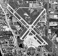
The major airport in the area is Sarasota-Bradenton International Airport which is shared by Sarasota and Manatee counties.[38] Five airlines offer service out of the airport to locations primarily in the United States and Canada. The airport serves more than 1,300,000 passengers per year. The airport holds full Port of entry status providing U.S. Customs inspections for international travelers.[38] St. Petersburg-Clearwater International Airport and Tampa International Airport are located about an hour north from Sarasota, and Southwest Florida International Airport in Ft. Meyers an hour and 45 min south of Sarasota. All 3 offer a wider range of national and international flights.
Sarasota County Area Transit has a bus service called SCAT which offers service throughout the county and also offers limited connections with Manatee County Area Transit. Sarasota County has joined the Tampa Bay Area Regional Transportation Authority to plan and build future transportation infrastructure including light rail, commuter rail and longer range bus service. A key issue is providing Sarasota with access to the Florida High Speed Rail. There is no Amtrak train which stops in Sarasota, but Amtrak provides through bus service at Sarasota Stationout front of the Hollywood 20 Movie Theatre downtown, to the nearest Amtrak terminal in Tampa.
As a city located on the Gulf of Mexico, water transportation is a key consideration. The Intracoastal Waterway is a 3000 mile(4,800-km) waterway providing water access to and from the Atlantic coast for tugs, barges and leisure boats. Port Manatee and the Port of Tampa both provide nearby deep water ports.[38]
Because of its location on the Gulf of Mexico and its proximity to several other large metropolitan areas, road transportation is critical to the Sarasota area. The major roads in the area include:
 I-75 - The only freeway in the area, I-75 is located 5 miles from the center of town and is a major interstate leading south to Miami and north to Tampa.
 U.S. 41 Tamiami Trail - A major north-south route through Sarasota enters central Sarasota from the south before heading west at the south end of U.S. 301. After briefly following Bayfront Drive the Trail heads north again paralleling the coast.
 U.S. 301 - Heading north from its intersection with U.S. 41, U.S. 301 follows Washington Boulevard running parallel to U.S. 41 and Interstate 75.
 SR 780 - 3rd Street/Fruitville Road - A main east/west throughway linking U.S. 41, U.S. 301, and Interstate 75.
 SR 789 - Starts out as John Ringling Causeway before heading to Bird Key and Lido Key, SR 789 turns north and becomes Gulf of Mexico Drive a major road on the islands between Sarasota and Bradenton.
Sister cities
See also: List of sister cities in FloridaThe city commission has chosen to designate the following cities as sister cities, a term used to describe cooperative agreements between communities in geographically and politically distinct areas, with the stated contemporary objective of promoting cultural and commercial ties. A twining tradition began with an agreement between two towns, the German city of Paderborn and the French city of Le Mans in 836. The modern adaptation in the United States began in 1931.
 Hamilton, Ontario, Canada (1990)[39]
 Perpignan, France (1994)[40]
 Tel Mond, Israel (1994)[41]
 Vladimir, Russia (1994)[42]
 Dunfermline, Fife, United Kingdom (2002)
 Treviso, Italy (Feb. 2007)[43]
 Xiamen, Fujian Province, China[44]
 Mérida, Yucatán, México (2010)
References
- ^ LaHurd, Jeff, Come on Down! : Pitching Paradise During the Roaring 20s, Sarasota Alliance for Historic Preservation, 1995 ISBN 9781888438000 ISBN 1888438002
- ^ "A - Z of Sarasota" (refer to "The Q")
- ^ "Florida by place Population, Housing Units, Area and Density:2000". U.S. Census Bureau. http://factfinder.census.gov/servlet/GCTTable?_bm=y&-geo_id=04000US12&-_box_head_nbr=GCT-PH1&-ds_name=DEC_2000_SF1_U&-format=ST-7. Retrieved 2007-07-24.
- ^ "Sarasota, United States Page". Falling Rain Genomics. http://www.fallingrain.com/world/US/12/Sarasota.html. Retrieved 2007-07-24.
- ^ "Annual Estimates of the population for the Incorporated Places of Florida" (XLS). U.S. Census Bureau. http://www.census.gov/popest/cities/tables/SUB-EST2005-04-12.xls. Retrieved 2007-07-24.
- ^ a b "American FactFinder". United States Census Bureau. http://factfinder.census.gov. Retrieved 2008-01-31.
- ^ "US Board on Geographic Names". United States Geological Survey. 2007-10-25. http://geonames.usgs.gov. Retrieved 2008-01-31.
- ^ "Sarasota". City Demographics. CityRating.com. http://www.cityrating.com/citystats.asp?city=Sarasota&state=FL. Retrieved 30 August 2010.
- ^ "?". http://www.sarasota-manateempo.org/.[dead link]
- ^ "Welcome to the Chairs Coordinating Committee Website". Charis Coordinating Committee. http://www.regionaltransportation.org/. Retrieved 30 August 2010.
- ^ "Did You Know... City Trivia P - T". Florida League of Cities Inc.. http://www.flcities.com/membership/city_trivia_pt.asp. Retrieved 30 August 2010.
- ^ Burnett Gene M. (1986) Florida's Past: People and Events that Shaped the State. Pineapple Press Inc., Sarasota, FL
- ^ "Preserve America Community: Sarasota, Florida". Preserve America. March 4, 2009. http://www.preserveamerica.gov/07-17-08PAcommunity-sarasotaFL.html. Retrieved 30 August 2010.
- ^ "?". Sarasota County Covernment. http://www.scgov.net/CommunityServices/HistoryCenter/Historic_Sarasota/wilson.asp.
- ^ "Mrs. Bertha Palmer's Vision". Sarasota History. http://www.sarasotahistoryalive.com/index.php?src=gendocs&ref=berthapalmer&category=People. Retrieved 30 August 2010.
- ^ "Bertha Palmer's Vision: Her Impact on Sarasota". Sarasota History Alive. http://www.sarasotahistoryalive.com/index.php?src=gendocs&ref=berthapalmer&category=People.
- ^ "?". Sarasota County Government. http://www.scgov.net/CommunityServices/HistoryCenter/Historic_Sarasota/palmer.asp.
- ^ http://www.sarasotahistoryalive.com/stories/journals-of-yesteryear/residence-of-hester-ringling-lancaster-sanford/ Benz, Kafi, Residence of Hester Ringling Lancaster Sanford, Sarasota History Alive!, Journals of Yesteryear, April 29, 2009
- ^ http://www.sarasotahistoryalive.com/stories/journals-of-yesteryear/residence-of-edith-ringling/ Benz, Kafi, Residence of Edith Ringling, Sarasota History Alive!, Journals of Yesteryear, December 8, 2010
- ^ "US Gazetteer files: 2010, 2000, and 1990". United States Census Bureau. 2011-02-12. http://www.census.gov/geo/www/gazetteer/gazette.html. Retrieved 2011-04-23.
- ^ "Monthly Averages for Sarasota, FL". The Weather Channel. 2008. http://www.weather.com/weather/wxclimatology/monthly/graph/USFL0446. Retrieved 2010-04-19.
- ^ "Census Of Population And Housing". U.S. Census Bureau. http://www.census.gov/prod/www/abs/decennial/index.htm. Retrieved 2008-10-28.
- ^ 2010 population report for Sarasota
- ^ "Narratives of the Meanest Cities - National Coalition for the Homeless". http://www.nationalhomeless.org/publications/crimreport/meanestcities.html. Retrieved April 2, 2010. Report in PDF.
- ^ "Sarasota, Fla. named meanest city for homeless". USA Today. 2006-01-13. http://www.usatoday.com/news/nation/2006-01-13-homeless-cities_x.htm. Retrieved April 2, 2010. "Sarasota, Fla. named meanest city for homeless," USAtoday and USAtoday.com, January 13, 2006.
- ^ "Tough on the homeless, city deemed heartless". http://www.sptimes.com/2006/01/30/State/Tough_on_the_homeless.shtml. Retrieved April 2, 2010. "Tough on the homeless, city deemed heartless: Sarasota defends its no-camping ordinance that won it the top spot on a national 'mean list'," St. Petersburg Times, Brady Dennis, January 30, 2006.
- ^ Walter, Nick (October 27, 2010). "Ground-breaking Street Painting". Pelican Press. JCPGroup. p. Features. http://www.pelicanpressonline.com/afterhours/features/105871718.html.
- ^ Toner, Moira (November 3, 2010). "Students chalk up accomplishments". Pelican Press. JCPGroup. p. Local News. http://www.pelicanpressonline.com/localnews/106623713.html.
- ^ Weingarten, Abby (October 28, 2010). "Street art goes global this year". Sarasota Herald Tribune. The New York Times Company. p. E6. http://www.heraldtribune.com/article/20101028/ARTICLE/10281004.
- ^ Ball, David (October 23, 2010). "Artists to make the pavement come alive in Sarasota". Sarasota Herald Tribune. The New York Times Company. p. BN1. http://www.heraldtribune.com/article/20101028/ARTICLE/10281004. Retrieved December 7, 2010.
- ^ "Top 50 TV markets ranked by households". Northwestern University Media Management Center. Archived from the original on 2007-08-07. http://web.archive.org/web/20070807070323/http://www.mediainfocenter.org/compare/top50/#tv. Retrieved 2007-09-03.
- ^ "Arbitron Radio Market Rankings: Spring 2007". Arbitron. http://www.arbitron.com/radio_stations/mm001050.asp. Retrieved 2007-09-03.
- ^ Jennings, David, A Tale of Two Commissions, Sarasota Alliance for Historic Preservation, Inc. Newsletter, February 2005, volume twenty, number two, Box 1754, Sarasota, Florida 34230 - with illustrations of Crocker Church and Bidwell-Wood House by Kafi Benz
- ^ LaHurd, Jeff, Sarasota, A History, The History Press, Charleston, South Carolina, IBSSN 1-59629-119-2
- ^ Joyce Owens (11 July 2009). "Rudolph's Riverview High School Demolished". originally published on News-press.com. Do.co.mo.mo-us.org. http://www.docomomo-us.org/news/florida_rudolphs_riverview_high_school_demolished. Retrieved 27 August 2010.
- ^ Baltimore Sun: Orioles reach deal for spring training set for Sarasota
- ^ "2008 Sarasota Marathon". 2008 Sarasota Marathon. http://www.runthenation.com/marathon/2008_Sarasota_Marathon. Retrieved 2009-01-08.
- ^ a b c "By Air, Sea and Road". Manatee Chamber of Commerce. http://www.manateechamber.com/manatee-county-transportation-information.aspx. Retrieved 2010-09-10.
- ^ "Hamilton, Province of Ontario, Canada: 1990". Sarasota Sister Cities Association. http://www.sarasotasistercities.org/Hamilton.html. Retrieved 2007-09-03.
- ^ "Perpignan, Languedoc-Roussillion, France: 1994". Sarasota Sister Cities Association. http://www.sarasotasistercities.org/Perpignan.html. Retrieved 2007-09-03.
- ^ "Tel Mond, Israel:1994". Sarasota Sister Cities Association. http://www.sarasotasistercities.org/Tel_mond.html. Retrieved 2007-09-03.
- ^ "Vladimir, Russia:1994". Sarasota Sister Cities Association. http://www.sarasotasistercities.org/Vladimir.html. Retrieved 2007-09-03.
- ^ "Treviso,Italy:2007". Sarasota Sister Cities Association. http://www.sarasotasistercities.org/Treviso.html. Retrieved 2007-09-03.
- ^ "Siming District, Xiamen, Fujian Province, China:Candidate City". Sarasota Sister Cities Association. http://www.sarasotasistercities.org/Siming_district.html. Retrieved 2007-09-03.
External links
- Sarasota County History Center
- City of Sarasota official site
- Sarasota Herald-Tribune Local News
- Siesta Key Chamber of Commerce
- Sarasota Convention and Visitors Bureau
Municipalities and communities of Sarasota County, Florida County seat: Sarasota Cities North Port | Sarasota | Venice

Town CDPs Bee Ridge | Desoto Lakes | Englewood‡ | Fruitville | Gulf Gate Estates | Kensington Park | Lake Sarasota | Laurel | The Meadows | Nokomis | North Sarasota | Osprey | Plantation | Ridge Wood Heights | Sarasota Springs | Siesta Key | Southgate | South Gate Ridge | South Sarasota | South Venice | Vamo | Venice Gardens | Warm Mineral Springs
Unincorporated
communityFootnotes ‡This populated place also has portions in an adjacent county or counties
Categories:- Youth sport
- Cities in Sarasota County, Florida
- County seats in Florida
- Sarasota, Florida
- Bradenton–Sarasota–Venice metropolitan area


Wikimedia Foundation. 2010.