- Marina Coastal Expressway
-
Marina Coastal Expressway
Route information Length: 5 km (3 mi) Existed: 2008 – present History: Scheduled for completion in 2013 Major junctions North end: Tanjong Rhu (KPE, ECP) KPE, ECP, AYE West end: Keppel (AYE) Location Regions: Marina Bay, Kallang Highway system The Marina Coastal Expressway (Abbreviation: MCE; Chinese: 滨海高速公路; pinyin: Bīnhǎi Gāosù Gōnglù; Malay: Lebuhraya Pantai Marina) is the second newest of Singapore's network of expressways, and is slated for construction commencement in 2008 and completion at the end of 2013.[1][2]
Route
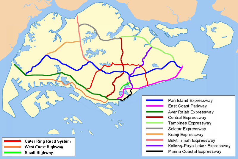
The 5 kilometres (3.1 mi) MCE will connect the southern end of the Kallang–Paya Lebar Expressway (KPE) and its junction with the East Coast Parkway to the eastern end of Ayer Rajah Expressway. This links the eastern and western parts of Singapore to the New Downtown, currently being developed in the Marina Bay area. The MCE, with five lanes in each direction, would handle the large number of commuters to be drawn to the offices, homes and recreational attractions there. It will also open access to the proposed Marina Cruise Centre in Marina South and the existing Marina South Ferry Terminal.[2]
Construction
The expressway will comprise a 3.5 kilometres (2.2 mi) underground tunnel, while the rest will be at grade or depressed, with a scenic view of the Straits of Singapore.[3] The underground tunnel includes a 420-metre stretch that will duck under the seabed, 150 m away from the Marina Barrage. This poses particular engineering challenges in the tunnel construction as large amounts of water will be let out from the barrage from time to time.[4] At its deepest point, the expressway will lie about 20 metres (66 ft) under the seabed.[2]
The 5 kilometres (3.1 mi) long MCE will be Singapore's most expensive expressway. On 28 April 2009, the Land Transport Authority revealed that it has awarded about S$4.1 billion worth of contracts[5], much more than the initial estimate of S$2.5 billion[1]. The construction of the MCE would also require undersea dredging. More than 22 hectares of land will be reclaimed to build the MCE.[2] In contrast, the KPE, which is 12 kilometres (7.5 mi) and has portions running under canals and rivers, costs only S$1.74 billion.
When the MCE is constructed, the segment of East Coast Parkway between Ayer Rajah Expressway and Benjamin Sheares Bridge will be downgraded to a four-lane arterial road and realigned.[1][3] The present East Coast Parkway blocks the expansion of the city southwards, and hence the revised layout allows the city to expand towards the New Downtown.[4]
The following contracts have been awarded for building the expressway:[6]
- Civil Contracts
- Contract 481 is awarded to Hock Lian Seng Infrastructure Ltd at a sum of S$305 million.
- Contract 482 is awarded to Ssangyong Engineering and Construction Co Ltd at a sum of S$929.9 million.
- Contract 483 is awarded to Samsung C&T Corporation at a sum of S$716.4 million.
- Contract 485 is awarded to Penta-Ocean Construction Co Ltd at a sum of S$669.7 million.
- Contract 486 is awarded to Samsung C&T Corporation at a sum of S$634.8 million.
- Contract 487 is awarded to Sato Kogyo(S) Pte Ltd - Daelim Industrial Co. Ltd Joint Venture at a sum of S$732.6 million.
- Electrical and Mechanical Contracts
- Contracts 465A and 465B are awarded to Tyco Fire, Security & Services Pte Ltd at a sum of S$14.1 million and S$21.9 million respectively.
- Contract 466 is awarded to Singapore Technologies Electronics Limited at a sum of S$8 million.
- Contract 467 is awarded to Nam Lee Pressed Metal Pte Ltd at a sum of S$37.1 million.
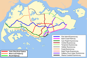 Marina Coastal Expressway is coloured black in this map.
Notes and references
- ^ a b c "Government Approves the Construction of MCE", Land Transport Authority, 27 July 2007
- ^ a b c d T. Rajan (28 July 2007). "New expressway in Marina to be ready by 2013". The Straits Times.
- ^ a b "Annex A: Alignment Map for MCE", Land Transport Authority, 27 July 2007
- ^ a b "ECP to be realigned for new Marina Coast Expressway", Channel NewsAsia, 27 July 2007
- ^ "Marina Coastal Expressway Breaks Ground Today", Land Transport Authority, 28 April 2009
- ^ Construction of Marina Coastal Expressway (MCE) - Annex A, ONE.MOTORING, Retrieved on 2009 April 29.
Future developments in Singapore Places Skyscrapers Other buildings Singapore Sports Hub · Reflections at Keppel Bay · Clifford Pier · South Beach · National Art Gallery of Singapore · School of the Arts · One Shenton Way · Khoo Teck Puat Hospital · Ng Teng Fong HospitalOther projects Gardens by the Bay · Marina Promenade · Collyer Quay · Ang Mo Kio ITE College Central Campus · Coney Island · River Safari · Singapore University of Technology and Design · Resorts World SentosaTransport Circle / Downtown / Eastern Region / Thomson MRT Lines · North-South MRT Line Extension · East-West MRT Line (Tuas West) Extension · Changi Airport Terminal Four · International Cruise Terminal · Marina Coastal Expressway · North–South ExpresswayReservoirs Punggol · SerangoonArchitecture of Singapore Expressways and semi-expressways of Singapore Expressways Ayer Rajah Expressway · Bukit Timah Expressway · Central Expressway · East Coast Parkway · Kallang–Paya Lebar Expressway · Kranji Expressway · Marina Coastal Expressway (U/C) · North–South Expressway (planned) · Pan Island Expressway · Seletar Expressway · Tampines Expressway
Semi-expressways Categories:- Expressways in Singapore
- Tunnels in Singapore
- Downtown Core (Singapore)
- Marina East
- Marina South
- Straits View
- Proposed roads
- Civil Contracts

Wikimedia Foundation. 2010.