- Carrollton, Georgia
Infobox Settlement
official_name = Carrollton, Georgia, USA
other_name =
native_name =
nickname =
settlement_type =City
motto =
imagesize =
image_caption =
flag_size =
image_
seal_size =
image_shield =
shield_size =
image_blank_emblem =
blank_emblem_type =
blank_emblem_size =
imagesize =
image_caption =
flag_size =
image_
seal_size =
image_shield =
shield_size =
image_blank_emblem =
blank_emblem_type =
blank_emblem_size =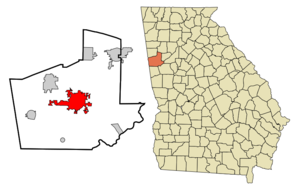
mapsize = 250px
map_caption = Location in Carroll County and the state of Georgia
mapsize1 =
map_caption1 =
image_dot_
dot_mapsize =
dot_map_caption =
dot_x =
dot_y =
pushpin_
pushpin_label_position =
pushpin_map_caption =
pushpin_mapsize =
subdivision_type = Country
subdivision_name =United States
subdivision_type1 = State
subdivision_name1 = Georgia
subdivision_type2 = County
subdivision_name2 = Carroll
subdivision_type3 =
subdivision_name3 =
subdivision_type4 =
subdivision_name4 =
government_footnotes =
government_type =
leader_title =Mayor
leader_name = Wayne Garner
leader_title1 =
leader_name1 =
leader_title2 =
leader_name2 =
leader_title3 =
leader_name3 =
leader_title4 =
leader_name4 =
established_title =
established_date =
established_title2 =
established_date2 =
established_title3 =
established_date3 =
area_magnitude = 1 E9
unit_pref = Imperial
area_footnotes =
area_total_km2 = 53.6
area_land_km2 = 52.2
area_water_km2 = 1.3
area_total_sq_mi = 20.7
area_land_sq_mi = 20.2
area_water_sq_mi = 0.5
area_water_percent =
area_urban_km2 =
area_urban_sq_mi =
area_metro_km2 =
area_metro_sq_mi =
area_blank1_title =
area_blank1_km2 =
area_blank1_sq_mi =
population_as_of = 2000
population_footnotes =
population_note =
population_total = 19,843
population_density_km2 = 379.8
population_density_sq_mi = 983.7
population_metro =
population_density_metro_km2 =
population_density_metro_sq_mi =
population_urban =
population_density_urban_km2 =
population_density_urban_sq_mi =
population_blank1_title =
population_blank1 =
population_density_blank1_km2 =
population_density_blank1_sq_mi =
timezone = EST
utc_offset = -5
timezone_DST = EDT
utc_offset_DST = -4
latd = 33 |latm = 34 |lats = 51 |latNS = N
longd = 85 |longm = 4 |longs = 36 |longEW = W
elevation_footnotes =
elevation_m = 336
elevation_ft = 1102
postal_code_type =
postal_code =
area_code = 770
blank_name = FIPS code
blank_info = 13-13492GR|2
blank1_name = GNIS feature ID
blank1_info = 0325833GR|3
website = http://www.carrollton-ga.gov/index.html
footnotes =Carrollton is a city in west central Georgia, in the foothills of the
Appalachian Mountains . It is the county seat of Carroll County, and the largest town in the county, with a population of 19,843 at the 2000 census.Historically, Carrollton has been a commercial and cultural center for Carroll and neighboring Georgia and
Alabama counties, and is the home of theUniversity of West Georgia and [http://www.southwire.com/ Southwire] , the world's largest privately-owned manufacturer of wire and cable.Geography
Carrollton is located at coor dms|33|34|51|N|85|4|36|W|city (33.580912, -85.076704).GR|1
According to the
United States Census Bureau , the city has a total area of 20.7square mile s (53.6km² ), of which, 20.2 square miles (52.2 km²) of it is land and 0.5 square miles (1.3 km²) of it (2.51%) is water.Climate and Weather
Source: US Census
Population Sex and Age
Source: US Census
Income
Source: US Census
History
Carroll County, of which Carrollton is the county seat, was chartered in 1826, and was governed at the time by the Carroll Inferior Court, which consisted of five elected justices. In 1829, the justices voted to move the county seat from the site it occupied near the present community of Sandhill, to a new site about eight miles to the southwest.Bonner, James C. (1970). Georgia’s Last Frontier: The Development of Carroll County. The University of Georgia Press.]
The original intention was to call the new county seat Troupville, in honor of former governor
George Troup , but Troup was not popular with the state government of the time, so theGeorgia General Assembly incorporated the town as Carrollton, in December 1829.In 1830, the town was surveyed and lots were laid out, with the central feature being the town square, which was later named Adamson Square, for local judge and congressman
William C. Adamson .Although it was the county seat and the main market town for most of Carroll County, transportation of both goods and passengers was difficult until the coming of the railroad in 1874, so Carrollton remained largely a frontier town until well after the
American Civil War .The coming of the railroad brought new prosperity to Carrollton. Farmers were able to bring their crops, mostly
cotton , to town for shipment to distant markets, and obtain the fertilizers and agricultural supplies they needed. At the same time, consumer goods were more readily available than ever before.The railroad also encouraged the growth of the fledgling industrial ventures, especially in the
textile industry, in and around Carrollton. These early textile mills, mostly water powered, served as the basis for a textile industry that helped ensure the town’s prosperity well into the 20th century.At the start of the 20th century, Carrollton boasted running water, had electric lighting and telephone service, and the town began paving its streets in 1918.
In 1906, Carrollton was chosen as the site of the Fourth District Agricultural and Mechanical School, which became West Georgia College in 1934, and is now a ten-thousand student university, the
University of West Georgia .Bonner, J.C., Myron W. House, James W. Mathews (1998). From A&M to State University: A History of the State University of West Georgia. State University of West Georgia Foundation.]Carrollton remained an agricultural and textile manufacturing center throughout the first half of the 20th century, but as the local production of cotton declined and the population became more urban, other industries began to take on a greater prominence.. Most notable is the [http://www.southwire.com/ Southwire Company] . Founded in Carrollton in 1950, Southwire is now one of the world’s largest manufacturers of wire and cable and is the largest privately owned wire manufacturer, with more than 1,500 local employees, and 5,000 employees worldwide. [ [http://www.southwire.com/processGetArticle.do?commonId=bf99aba544bbef00VgnVCM1000002702a8c0____/ Over 50 Years of Quality and Service.] Southwire Company. Retrieved 7/30/07.]
This diversification of industry has continued into the 21st century, aided in part by Carrollton’s ready access to
Interstate 20 and theNorfolk Southern Railway . The town’s major employers presently include companies in the airline, construction, power distribution, poultry, software, home entertainment, and health care industries, among others. [ [http://www2.carroll-ga.org/economic%20profile%202007.pdf/ Carroll County Location and Land Facts. (PDF)] Carroll County Chamber of Commerce. Retrieved 7/31/07.]Carrollton also remains an important market town, with a wide variety of national retail chains and restaurants, serving Carroll and neighboring Georgia and Alabama counties.
Carrollton featured in the 1983 TV movie "Murder In Coweta County", although the Carrollton scenes were not actually filmed there. The town was also mentioned in Margaret Mitchell’s 1936 novel
Gone with the Wind , and in the 1939 movie of the same name. In 1946, artistNorman Rockwell visited the Oak Mountain school, near Carrollton, to paint a rural schoolhouse for an article that appeared inThe Saturday Evening Post in November of that year.Academy Award winning actress
Susan Hayward married a Carrollton man, Eaton Chalkley, and they lived in Carrollton from the time of their marriage in 1957 until his death in 1966. Hayward died in 1975, and is buried next to her husband, on the grounds of Our Lady of Perpetual Help Roman Catholic Church in Carrollton, which is built on land donated by the couple.Parks and Recreation
For outdoor recreation, several parks are located near Carrollton.
John Tanner State Park has a lake with a beach and swimming area, walking or running track, and camp grounds. Another local favorite is McIntosh Reserve, a county-run park along the Chattahoochee River. McIntosh Reserve is named for local historic figureWilliam McIntosh .Another beautiful outdoor area near Carrollton is Banning Mills, once a small mill community and now a picturesque resort and retreat.
Culture
Carrollton has a small but vibrant downtown area. Local favorite restaurants include the Corner Cafe, The Irish Bred Pub, Miller's, Camacho's, Mia Bella, The Alley Cat, Plates on the Square and Gallery Row Coffee Shop; all within walking distance of one another. Of these, Camacho's, Irish Bred Pub, The Alley Cat, and Miller's frequently schedule bands and other events. Adamson Square is the host to many of Carrollton's exciting events, such as the annual Mayfest which takes place in the first week of May. Another unique shop located on Adamson Square is Horton's Books & Gifts, certified as the oldest bookstore in Georgia by the American Booksellers Association. Founded in 1892, it is also Carrollton and Carroll County's oldest business.
Carrollton has a tight-knit music community. Singers and instrumentalists alike often bond together to produce concerts and albums such as "Did You Hear Something" and "Did You Hear Something Too" which were both released in the 90's. Ottotune Records also released a CD featuring local West Georgia artists.
Among businesses near the square is The Squire Shop, formerly owned by local businessman, Charles Willis. Another on-the-square business is Willis Jewelry Co., owned by Chuck Willis.
Notes
Another unique shop located on Adamson Square is Horton's Books & Gifts, certified as the oldest bookstore in Georgia by the American Booksellers Association. Founded in 1892, it is also Carrollton and Carroll County's oldest business.External links
Wikimedia Foundation. 2010.