- Demographic history of Bačka
-
This is demographic history of Bačka. This article contains data from various population censuses conducted in the region of Bačka during the history. Censuses from 1715 to 1910 contain data about population of the entire Bačka, while censuses from 1921 to 2002 contain data about population of the Yugoslav/Serbian part of Bačka.
Contents
Overview
Before the Hungarian conquest in the 10th century, Bačka was mainly populated by Slavs [1] and Avars. There is a dispute whether remains of ethnic Avars still lived in the region in the time of Hungarian conquest or they were already assimilated by more numerous Slavs. [2] In the 11-15th centuries, the region had mostly Hungarian population with Slavic ethnic islands.[3] During Hungarian rule, the native Slavic population mostly lost its Slavic language and culture and was assimilated into Hungarians.[4] Since the 14th century, Slavic Serbs started to migrate to this region from Balkans. In the outset of the 16th century, before the Ottoman conquest, the largest part of population of Bačka were Hungarians, and the smaller part of population were Slavs. After the Ottoman conquest, most of the Hungarian and Catholic Slavic population fled from the area, and new Orthodox settlers (Serbs, Vlachs, etc) as well as many Muslims of various ethnic origins settled in the area. During Ottoman rule, the region was mainly populated by Serbs, who were in an absolute majority [2] and who mostly lived in villages, while cities were populated by various Muslim and Christian ethnic groups including Serbs, Turks, Roma, Greeks, Cincars, Arabs, Bosniaks, as well as Jews. During the Habsburg rule, in the 17th and 18th century, new wave of Serb settlers came to the area. During the 18th and 19th century, Hungarian, German, and other (Slovak, Rusyn, etc) colonists came to the area, which thus became ethnically mixed with population composed mostly of Serbs, Hungarians, and Germans. Hungarian colonists mostly originated from Upper Hungary, especially from those counties that were not under Ottoman rule. [5] There is dispute whether some of these Hungarians were descendants of pre-Ottoman Hungarian population of Bačka. When Austrians conquered Bačka and tried to determine private land ownership in the region, the only Hungarians that were able to prove that their ancestors owned land in Bačka were members of Cobor family, who proved their ownership rights over town of Baja. [6] In early 20th century, Bačka was ethnically mixed with relative Hungarian linguistic plurality. During 20th century (after 1918), many South Slavic colonists from other parts of Yugoslavia (Serbs, Montenegrins, Macedonians, Muslims by nationality, etc) settled in the area, mainly after 1945 and between 1991-1996.
Entire (historical) Bačka
1715
According to the Austrian census from 1715, there were 58 settlements in Bačka (excluding 18 settlements from military frontier). Largest places in Bačka in this time were Baja (with 237 recorded houses) and Futog (with 137 recorded houses).[7]
This census recorded all inhabitants of Bačka that had to pay taxes to authorities, excluding those that were not obligated to pay taxes (for example people that did not had their own house or people that served as soldiers in the military frontier) as well as those that were hiding from authorities with goal to avoid tax paying.
1715 census did not recorded ethnicity or language of the citizens, but analysys of names and surnames of the people from census results provided data about approximate ethnic composition of the area, which was as follows:[1][8]
- 97.6% people with South Slavic (Serb, Bunjevac, Šokac) names and surnames
- 1.9% (or 530 people) with Hungarian names and surnames
- 0.5% people with German names and surnames
1720
The 1720 census recorded 104,569 citizens in the Bačka region. Unlike census from 1715, this census recorded inhabitants of the military frontier as well (thus, census results also include frontiersmen from the city of Szeged, who were also under jurisdiction of the military frontier).
1720 census also did not recorded ethnicity or language of the citizens, but analysys of names and surnames of the people from census results provided data about approximate ethnic composition of the area, which was as follows:[9]
- 98,000 (94%) people with South Slavic names and surnames, of which:
- 5,019 people with Hungarian names and surnames
- 750 people with German names and surnames
1820
By 1820 the population of the Bacsensis-Bodrogiensis County reached 387,914 in total population, and included following ethnicities:[9]
- South Slavs (Serbs, Bunjevci, Šokci) = 170,942 (44%)
- Hungarians = 121,688 (31%)
- Germans = 91,016 (23%)
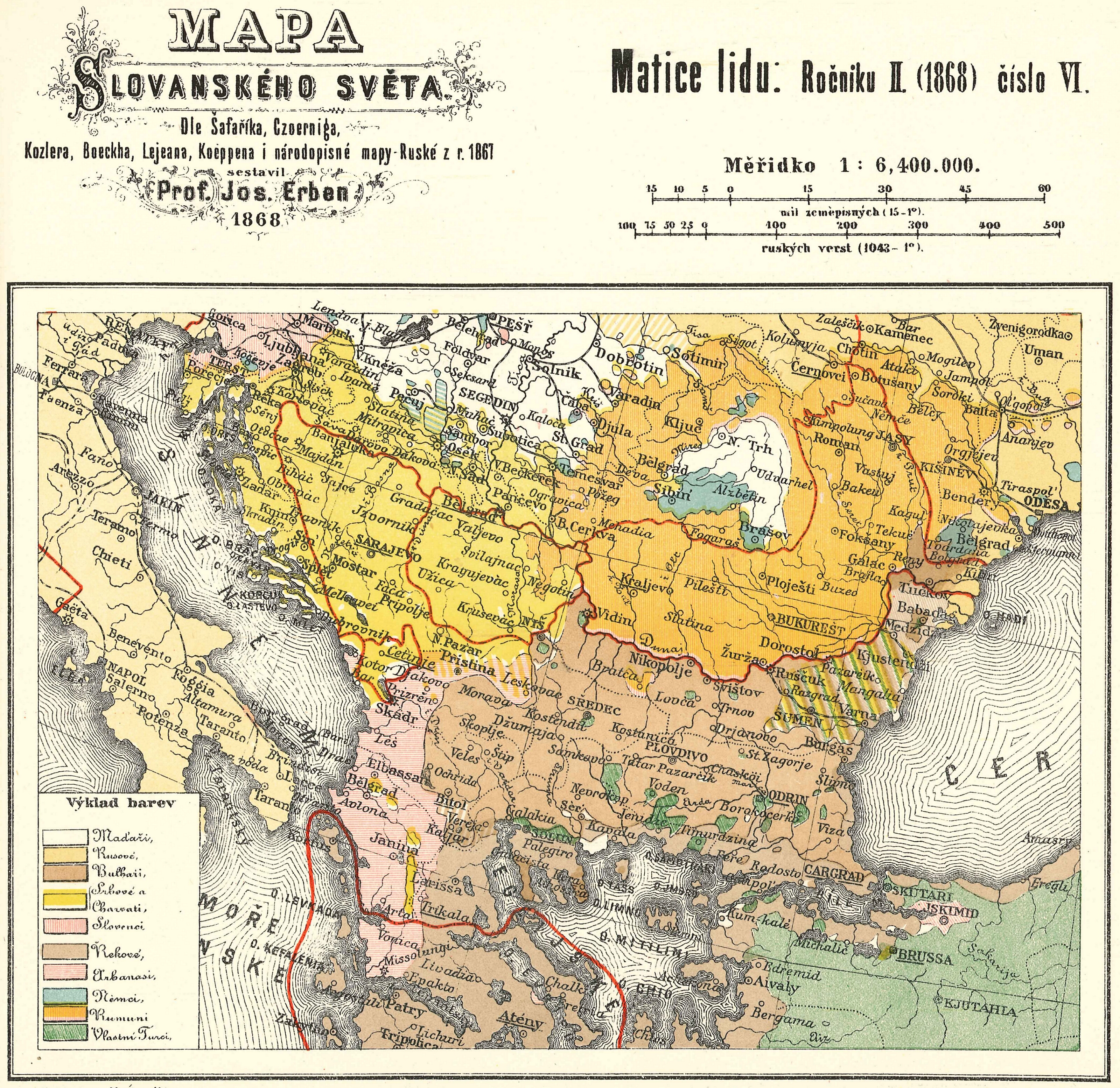
1860
 Ethnic map of Bačka in 1868
 Ethnic map of Bačka in 1880
1880
1890
1900
1910
According to the census of 1910, Bács-Bodrog County had 812,385 inhabitants. Population by mother language (1910 census):[10]
- Hungarian = 363,518 (44.75%)
- German = 190,697 (23.47%)
- Serbian = 145,063 (17.86%)
- Slovak = 30,137
- Russniak = 10,760
- Croatian = 1,279
- Romanian = 386
- other languages = 70,545 (including Bunjevac and Šokac)
As for the geographical distribution of the three largest ethnic groups in 1910, Hungarians mainly lived in northern parts of the region, Germans in western, and Serbs in the southern parts. Újvidék (Serbian: Novi Sad), city in the southern part of the region, was the cultural and political centre of the Serb people in the 18th and 19th century. After the end of the First World War, the territory of the county was divided between the Kingdom of Serbs, Croats and Slovenes (Yugoslavia) and Hungary.
Yugoslav/Serbian Bačka
1921
According to the Yugoslav census of 1921, Yugoslav part of Bačka had a population of 735,117, of whom:[11]
- 260,998 (35.50%) spoke Hungarian language
- 246,598 (33.55%) spoke Serbian and Croatian language
- 173,796 (23.64%) spoke German language
- 30,993 (4.22%) spoke Slovak language
- 10,999 (1.50%) spoke Rusyn language
- 4,850 (0.66%) spoke Slovene language
Of the 105 communes in the Yugoslav Bačka, the Germans were in a majority in 36, the Yugoslavs in 31, the Magyars in 23, and the Slovaks in 7, while in 8 communes no one language-group predominated. Of the eleven administrative districts into which the Yugoslav Bačka was divided, the German-speaking communes were in a majority in Odžaci and Palanka, the Serb and Croat in Žabalj and Titel and the Magyar in Senta and Topola. In the remaining five districts, the communes of no single language group were in predominance.
1931
According to the Yugoslav census of 1931, Yugoslav part of Bačka had a population of 784,896, of whom: [3]
- 284,865 (36.29%) spoke Serbian and Croatian language
- 268,711 (34.24%) spoke Hungarian language
- 169,858 (21.64%) spoke German language
- 34,234 (4.36%) spoke Slovak language
- 11,414 (1.45%) spoke Rusyn language
- others.
1941
According to Hungarian census from end of 1941, population of Yugoslav part of Bačka numbered 789,705 inhabitants, of whom:[12]
- 358,531 (45.4%) spoke Hungarian language
- 162,070 (20.52%) spoke German language
- 151,269 (19.15%) spoke Serbian language (*)
- 62,303 (7.89%) spoke Croatian language (*)
- 32,578 (4.12%) spoke Slovak language
- 13,829 (1.76%) spoke Rusyn language
(*) Total number of speakers of South Slavic languages (Serbian and Croatian) was 213,572 (27.05%).
1948
According to the Yugoslav census of 1948, Yugoslav Bačka had a population of 807,122, including: [4]
- 307,343 (38.07%) Hungarians
- 303,664 (37.62%) Serbs
- 88,491 (10.96%) Croats
- 36,041 (4.44%) Slovaks
- 17,269 (2.18%) Rusyns
- 10,638 (1.32%) Germans
- others.
1953
According to the Yugoslav census of 1953, Yugoslav part of Bačka had a population of 831,945, including: [5]
- 317,247 (38.12%) Serbs
- 311,146 (37.38%) Hungarians
- 80,957 (9.73%) Croats
- 36,424 (4.38%) Slovaks
- 18,162 (2.18%) Rusyns
- others.
1961
According to the Yugoslav census of 1961, Yugoslav part of Bačka had a population of 920,600, including: [6]
- 386,385 (41.08%) Serbs
- 320,566 (34.83%) Hungarians
- 101,509 (11.03%) Croats
- 37,665 (4.09%) Slovaks
- others.
1971
According to the Yugoslav census of 1971, the population of Yugoslav Bačka numbered 960,001 people, including:[13]
- 413,895 (43.11%) Serbs
- 311,379 (32.44%) Hungarians
- 92,207 (9.60%) Croats
- 36,508 (3.80%) Slovaks
- 31,120 (3.24%) Montenegrins
- 27,651 (2.88%) Yugoslavs
- 16,580 (1.73%) Rusyns
- others.
1981
According to the Yugoslav census of 1981, the population of Yugoslav Bačka numbered 1,012,112 people, including: [7]
- 434,178 (40.9%) Serbs
- 287,565 (30.36%) Hungarians
- 91,757 (9.86%) Yugoslavs
- 71,793 (7.09%) Croats
- 34,997 (3.02%) Slovaks
- 16,020 (1.68%) Rusyns
- others.
1991
According to the Yugoslav census of 1991, the population of Yugoslav Bačka numbered 1,007,179 people, including: [8]
- 463,029 (46.15%) Serbs
- 258,724 (26.63%) Hungarians
- 98,052 (10.22%) Yugoslavs
- 65,663 (6.74%) Croats
- 32,092 (3.3%) Slovaks
- 14,895 (1.11%) Rusyns
- others.
2002
 Ethnic map of Serbian Bačka (2002 census)
According to the Yugoslav census of 2002 in Yugoslav part of Bačka has been living 1,022,524 people and its population is composed of:[14]
- 559,700 (54.74%) Serbs
- 221,882 (21.70%) Hungarians
- others (including Slovaks, Croats, Bunjevci, Šokci, Rusyns, Montenegrins, Yugoslavs, Roma, Germans, etc).
Hungarian Bácska
2001
According to Hungarian census of 2001 census in Hungary, in Hungarian Bácska (including districts of Bajai, Bácsalmási, and Jánoshalmai) were living 113,432 people.[15] Note that administrative borders of the districts do not fully correspond with the geographical borders of Hungarian Bácska. Most of the inhabitants of Hungarian Bácska are ethnic Hungarians.[16]
Census methodology
First censuses conducted in Bačka were Ottoman tax records (defters) from 1554, 1570 and 1590. These tax records recorded only those inhabitants of Bačka that paid taxes to the Ottoman authorities, while those inhabitants that did not had to pay taxes (for example those that were in Ottoman service) were not listed in tax records.
During the Habsburg administration, first censuses in Bačka were conducted in 1715 and 1720. These censuses also recorded only those inhabitants that had to pay taxes to the Habsburg authorities, while those inhabitants that did not had to pay taxes (for example those that did not had their own house) were excluded from census. These censuses did not recorded ethnicity or mother tongue of the citizens.
Later Habsburg and Yugoslav censuses recorded language spoken by the citizens, and since 1948, censuses are also recording ethnicity of the people.
See also
Notes
- ^ a b Andrija Bognar, Položaj Mađara u Vojvodini od 1918. do 1995., Međunarodni znanstveni skup "Jugoistočna Europa 1918.-1995.", Zadar, 28.-30. rujna 1995.
- ^ Peter Rokai - Zoltan Đere - Tibor Pal - Aleksandar Kasaš, Istorija Mađara, Beograd, 2002, pages 14-15.
- ^ Károly Kocsis, Eszter Kocsisné Hodosi, Ethnic Geography of the Hungarian Minorities in the Carpathian Basin, Simon Publications LLC, 1998, p. 138-139 (Fig. 34.) [1]
- ^ Lazar Stipić, Istina o Mađarima, Novi Sad - Srbinje, 2004.
- ^ D. J. Popović, Slika Vojvodine u 18. veku, Zbornik "Vojvodina", knjiga 2, Fototipsko izdanje, PROMETEJ, Novi Sad, 2008, page 89.
- ^ D. J. Popović, Plemstvo, Zbornik "Vojvodina", knjiga 2, Fototipsko izdanje, PROMETEJ, Novi Sad, 2008, page 112.
- ^ Ivan Jakšić, Iz popisa stanovništva Ugarske početkom XVIII veka, Novi Sad, 1966, page 18
- ^ http://hic.hr/books/seeurope/011e-bognar.htm
- ^ a b Jovan Pejin, Velikomađarski kapric, Zrenjanin, 2007. (page 28)
- ^ Bács-Bodrog County
- ^ http://www.hungarian-history.hu/lib/romsics/w25.htm
- ^ Medjunarodni znanstveni skup "Jugoistocna Europa 1918.-1995."
- ^ Dr. Branislav Bukurov, Bačka, Banat i Srem, Novi Sad, 1978.
- ^ Popis stanovništva, domaćinstava i stanova 2002. Knjiga 1: Nacionalna ili etnička pripadnost po naseljima. Republika Srbija, Republički zavod za statistiku Beograd 2003. ISBN 86-84443-00-09
- ^ http://www.nepszamlalas.hu/hun/kotetek/06/03/data/tabhun/4/load01_1_0.html
- ^ http://lazarus.elte.hu/hun/maps/ke2500.gif
External links
Categories:- History of Bačka


Wikimedia Foundation. 2010.