- Deep-ocean Assessment and Reporting of Tsunamis
-
 A diagram of the Dart II System
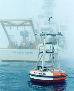
 A tsunami buoy
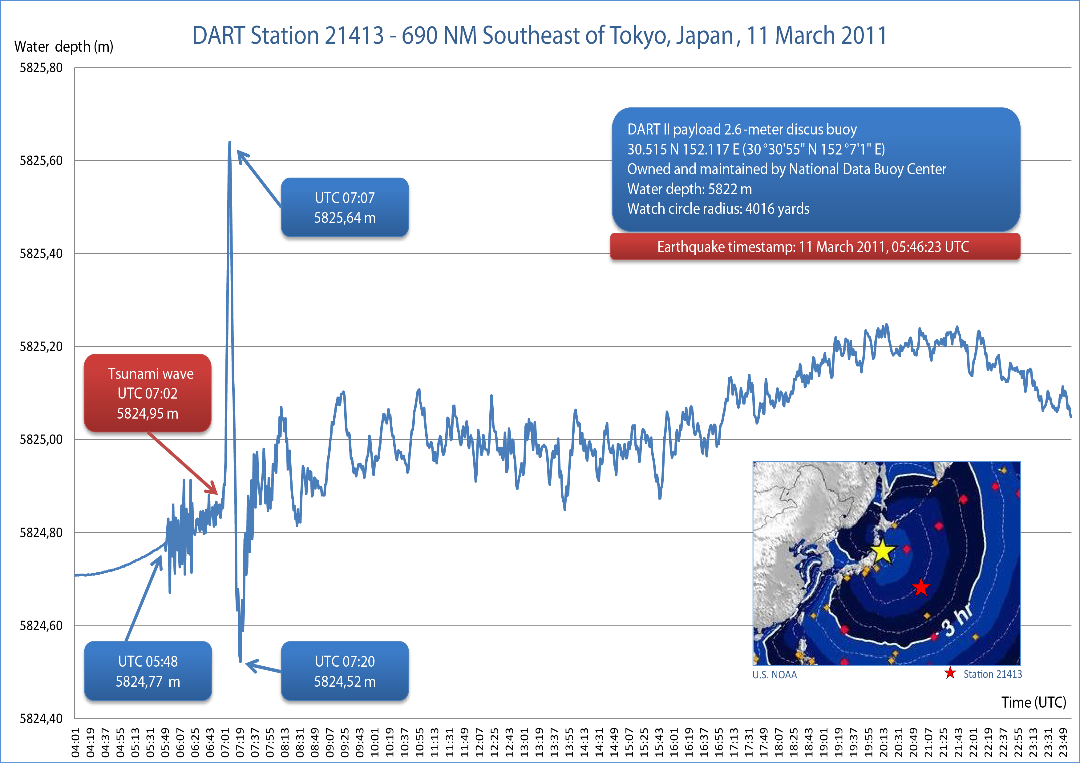
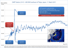 Water column height on 11 March 2011 (Tōhoku earthquake and tsunami) at DART buoy 21413, 690 NM Southeast of Tokyo
 Plot of measurements from DART buoy 34142 showing the passage of the tsunami generated by the 2010 Chile earthquake. Buoy 34142 is located in the southeastern Pacific Ocean 630 nautical miles (1170 km) southwest of Lima.
The Deep-ocean Assessment and Reporting of Tsunamis (officially abbreviated and trademarked as DART®[1]) system is a component of an enhanced tsunami warning system.
Contents
Stations
Each DART® station consists of a surface buoy and a seafloor bottom pressure recording (BPR) package that detects pressure changes caused by tsunamis. The surface buoy receives transmitted information from the BPR via an acoustic link and then transmits data to a satellite, which retransmits the data to ground stations for immediate dissemination to NOAA's Tsunami Warning Centers, NOAA's National Data Buoy Center, and NOAA's Pacific Marine Environmental Laboratory (PMEL). The Iridium commercial satellite phone network is used for communication between 31 of the buoys.[2]
When on-board software identifies a possible tsunami, the station leaves standard mode and begins transmitting in event mode. In standard mode, the station reports water temperature and pressure (which are converted to sea-surface height) every 15 minutes. At the start of event mode, the buoy reports measurements every 15 seconds for several minutes, followed by 1-minute averages for 4 hours.[3]
The first-generation DART I stations had one-way communication ability, and relied solely on the software's ability to detect a tsunami to trigger event mode and rapid data transmission. In order to avoid false positives, the detection threshold was set relatively high, presenting the possibility that a tsunami with a low amplitude could fail to trigger the station.
The second-generation DART II is equipped for two-way communication, allowing tsunami forecasters to place the station in event mode in anticipation of a tsunami's arrival.
History
The DART buoy technology was developed at PMEL[4], with the first prototype deployed off the coast of Oregon in 1995. In 2004, the DART® stations were transitioned from research at PMEL to operational service at the National Data Buoy Center (NDBC), and PMEL and NDBC received the Department of Commerce Gold Medal "for the creation and use of a new moored buoy system to provide accurate and timely warning information on tsunamis"[5].
In the wake of the 2004 Indian Ocean earthquake and its subsequent tsunamis, plans were announced to deploy an additional 32 DART II buoys around the world.[6] These would include stations in the Caribbean and Atlantic Ocean for the first time.
The United States' array was completed in 2008 totaling 39 stations in the Pacific Ocean, Atlantic Ocean, and Caribbean Sea. The international community has also taken an interest in DART buoys and as of 2009 Australia, Chile, Indonesia and Thailand have deployed DART buoys to use as part of each country's tsunami warning system.
See also
References
- ^ DART® website with Patent Licensing Application form
- ^ tracks tsunami buoys for NOAA
- ^ http://www.ndbc.noaa.gov/dart/dart.shtml
- ^ DART® development Publications & References
- ^ Note: The Gold Medal is granted for distinguished contributions and is the highest honorary recognition bestowed by the Department of Commerce. Because so many people contributed to this success, the Gold Medal was presented as an organizational award.
- ^ http://www.noaanews.noaa.gov/stories2005/s2369.htm
External links
- NOAA NDBC Deep-ocean Assessment and Reporting of Tsunamis (DART®)
- NOAA NCTR Deep-ocean Assessment and Reporting of Tsunamis (DART®)
- Realtime DART buoy data from the National Data Buoy Center
- High-resolution archived data from the National Geophysical Data Center
- Social & Economic Benefits of the DART system from "NOAA Socioeconomics" website initiative
- NOAA Tsunami website
- National Tsunami Hazard Mitigation Program
Earth-based meteorological observation systems and weather stations General Aircraft report (AIREP) · Automatic weather station (AWS) · Automated airport weather station · Dropsonde · Hurricane Hunters · Binary Universal Form for the Representation of meteorological data (BUFR) · Meteorological Aerodrome Report (METAR) · Pilot report (PIREP) · SST buoys · Tide gauge · Weather balloon · Weather buoy · Weather shipBy region WorldwideArgo · Global Atmosphere Watch (GAW) · Aircraft Communication Addressing and Reporting System (ACARS) · Aircraft Meteorological Data Relay (AMDAR) · Global Sea Level Observing System (GLOSS) · Deep-ocean Assessment and Reporting of Tsunamis (DART) · FluxNet Project (FluxNet)United StatesCitizens Weather Observer Program (CWOP) · Coastal-Marine Automated Network (C-MAN) · NEXRAD radar · Remote Automated Weather Station (RAWS) · Tropospheric Airborne Meteorological Data Reporting (TAMDAR)Categories:


Wikimedia Foundation. 2010.