- Hawaiian Ocean View, Hawaii
-
Hawaiian Ocean View, Hawaii — CDP — Location in Hawaii County and the state of Hawaii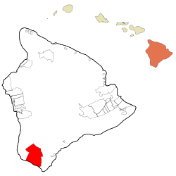
Coordinates: 19°6′28″N 155°46′2″W / 19.10778°N 155.76722°WCoordinates: 19°6′28″N 155°46′2″W / 19.10778°N 155.76722°W Country United States State Hawaii County Hawaii Area - Total 106.5 sq mi (275.8 km2) - Land 102.0 sq mi (264.2 km2) - Water 4.5 sq mi (11.6 km2) Elevation 1,575 ft (480 m) Population (2010) - Total 4,437 - Density 43.5/sq mi (16.8/km2) Time zone Hawaii-Aleutian (UTC-10) Area code(s) 808 FIPS code 15-12530 GNIS feature ID 1867253 Hawaiian Ocean View (usually referred to as "Ocean View") is a census-designated place (CDP) in Hawaiʻi County, Hawaiʻi, United States located in the District of Kaʻū. It includes the subdivisions of Hawaiian Ocean View Estates (HOVE), Hawaiian Ocean View Ranchos, Kahuku Country Gardens, Kula Kai View Estates, Kona Gardens, Keone's Ranchos, and Kona View Estates. The population was 2,178 at the 2000 census. The population increased by 103.7% to 4,437 at the 2010 census. [1]
Contents
History
The HOVE development consisted of 10,697 1-acre (4,000 m2) lots north of the Hawaii Belt Road in the western part of the District of Kaʻū. The terrain varies from rugged lava fields to ohiʻa trees and other vegetation. Elevation ranges from about 1,500 ft (460 m) up to the 5,000-foot (1,500 m) level. Initial sales began in the late 1950s. The original developer of HOVE was the Crawford Oil Company. Later, other subdivisions were put in place downslope of HOVE and the Hawaii Belt Road. In the early 1980s a service station and a hardware store were built. In January 2004, Hawaii Volcanoes National Park purchased the nearby property previously known as Kahuku Ranch.[2]
In 1989 the Ocean View Town Center was developed and the Ocean View Road Maintenance Corporation began an extensive rebuilding program of the roads. Shortly thereafter the Ocean View Development Corporation started a new market which included a laundromat and restaurant. Ocean View now has two shopping centers.[3]
Ocean View has a post office with the ZIP code of 96737.[4]
Geography
Ocean View is located at 19°6′28″N 155°46′2″W / 19.10778°N 155.76722°W (19.107649, -155.767186),[5] on the southwest rift zone of the shield volcano Mauna Loa.
Its elevation is 2,894 feet (882 m).[6]
According to the United States Census Bureau, the CDP has a total area of 106.5 square miles (276 km2), of which 102.0 square miles (264 km2) is land and 4.5 square miles (12 km2) of it (4.20%) is water.
Demographics
As of the census of 2010, there were 4,437 people in 1,759 households residing in the CDP. The population density was 43.5 people per square mile (16.8/km²). There were 2,247 housing units at an average density of 22.0 per square mile (8.5/km²). The racial makeup of the CDP was 48.73% White, 0.61% African American, 0.95% American Indian & Alaska Native, 5.52% Asian, 19.97% Native Hawaiian & Pacific Islander, 2.19% from other races, and 22.04% from two or more races. Hispanic or Latino of any race were 10.59% of the population. [7]
There were 1,759 households out of which 22.2% had children under the age of 18 living with them. The average household size was 2.52. [8]
In the Hawaiian Ocean View CDP the population was spread out with 24.7% under the age of 18, 5.5% from 18 to 24, 10.8% from 25 to 34, 17.2% from 35 to 49, 29.7% from 50 to 64, and 12.1% who were 65 years of age or older. For every 100 females there were 108.9 males. For every 100 males there were 91.8 females. [9]
The median income for a household in the CDP at the 2000 census was $26,125, and the median income for a family in 2000 was $34,234. Males had a median income of $28,523 in 2000 versus $20,938 for females. The per capita income for the CDP in 2000 was $15,218. About 13.0% of families and 25.2% of the population were below the poverty line in 2000, including 32.3% of those under age 18 and 16.5% of those age 65 or over.
References
- ^ US Census Bureau - 2010 Population Finder - Hawaiian Ocean View CDP [1]
- ^ Kaʻu Chamber of Commerce web site
- ^ HOVE information at the South Point web site
- ^ US Post Office Zip Code lookup
- ^ "US Gazetteer files: 2010, 2000, and 1990". United States Census Bureau. 2011-02-12. http://www.census.gov/geo/www/gazetteer/gazette.html. Retrieved 2011-04-23.
- ^ U.S. Geological Survey Geographic Names Information System: Hawaiian Ocean View, Hawaii
- ^ US Census Bureau - 2010 Population Finder - Hawaiian Ocean View CDP [2]
- ^ US Census Bureau - 2010 Population Finder - Hawaiian Ocean View CDP [3]
- ^ US Census Bureau - 2010 Population Finder - Hawaiian Ocean View CDP [4]
Municipalities and communities of Hawaii County, Hawaii CDPs Ainaloa | Captain Cook | Eden Roc | Fern Acres | Fern Forest | Halaula | Hawaiian Acres | Hawaiian Beaches | Hawaiian Ocean View | Hawaiian Paradise Park | Hawi | Hilo | Holualoa | Honalo | Honaunau-Napoopoo | Honokaa | Honomu | Kahaluu-Keauhou | Kailua | Kalaoa | Kapaau | Keaau | Kealakekua | Kukuihaele | Kurtistown | Laupāhoehoe | Leilani Estates | Mountain View | Naalehu | Nanawale Estates | Orchidlands Estates | Paauilo | Pahala | Pahoa | Papaikou | Pepeekeo | Paukaa | Puako | Volcano | Waikoloa Village | Waimea | Wainaku

Unincorporated
communitiesDistricts Categories:- Census-designated places in Hawaii County, Hawaii
- Populated places on Hawaii (island)


Wikimedia Foundation. 2010.